
-
 5875 Hits
-
 77.48% Score
-
 8 Votes
|
|
Mountain/Rock |
|---|---|
|
|
41.69336°N / 103.48666°W |
|
|
Banner |
|
|
Hiking |
|
|
4330 ft / 1320 m |
|
|
Overview
 Coyote Canyon
Smokestack Rock is located at the mouth of Coyote Canyon in Banner County on private land southwest of the small town of McGrew, Nebraska, and southeast of the cities of Scottsbluff and Gering, Nebraska. Like all of its neighboring hills, peaks, and rocks, it is composed of a mixture of sandstone, limestone, volcanic ash, and siltstone, eroded to a unique shape due to thousands of year of weathering.
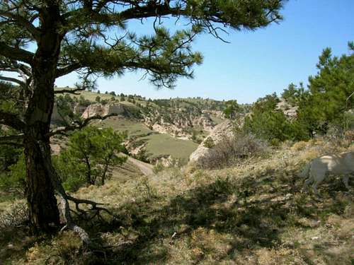
 Nearing the summit
Hiking to the summit area of Smokestack Rock can be as simple as a steep climb up the mostly unobstructed east face. Or, hikers can traverse Coyote Canyon, immediately to the south, and come around from the west side. The Coyote Canyon route is preferable to some because of the scenic beauty of the canyon and all its rock formations. It is also a good location to see fossils and to collect unique rocks. Because Smokestack Rock is on private property, it is very important to see permission first before any attempts. The landowners live just to the north of the summit at the base of the rock. It is best if you inquire there.
Getting There & Route
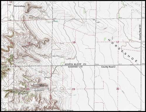 Smokestack Rock Map
To get to the base of Smokestack Rock, go south of McGrew on Main Street, which is County Road 34, which turns west and becomes County Road W until it turns again to the south and becomes County Road 33. Follow Road 33 south until you come to County Road Z, which is also County Road 44. Go west and follow the road to the end, which should lead you right to the base and the home of the owners.
 Nearby Chimney Rock
It is only a short, but steep bushwhack to the summit from the home of the owners. The lack of heavy forestation makes this a line of sight venture. If the owners will allow it, a more scenic route is to hike along the south side of Smokestack Rock into Coyote Canyon, then ascend the gentler slope on the west end and follow the game trail on the top of the ridge back to the east to the rock composite column that is called Smokestack Rock. Another possible route includes an old 2-track road that curves around the rock from the owner’s home into the side of Coyote Canyon, then up that western slope to the summit area.
Red Tape
This is on private property, so "red tape" is whatever agreement you have with the landowner.
When to Climb
Weather will probably be the greatest factor to influence your choice of when to climb. Factors like summer lightning, 100-degree weather or winter blizzards make postponing such a climb to a better time a good idea. You can access the weather for the area at this link: Smokestack Rock - Scottsbluff Area Weather
Camping and Lodging Resources
 100 Years Ago
 Nearby Castle Rock
The nearby towns of Scottsbluff and Gering to the northwest, or Bridgeport to the northeast, should offer you plenty of camping or lodging resources, plus food and supplies. Scottsbluff-Gering Chamber of Commerce Bridgeport Chamber of Commerce