
-
 5768 Hits
-
 84.27% Score
-
 18 Votes
|
|
Mountain/Rock |
|---|---|
|
|
47.62890°N / 15.86005°E |
|
|
Download GPX » View Route on Map |
|
|
Hiking, Skiing |
|
|
Spring, Summer, Fall, Winter |
|
|
4997 ft / 1523 m |
|
|
Topographic isolation: 8 km
Nearest higher peak: Stuhleck (1782 m)
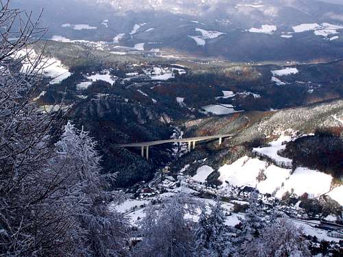
Prominence: 250 m![One of the viaducts of the S6 highway]()
One of the viaducts of the S6 highwayWhat is really famous here is not Sonnwendstein but Semmering Pass (984 m).
Semmering Pass is one of the two most important Alpen passes connecting Lower Austria with Styria. Highway S6 passes here, with huge traffic of 12500 car units per day. S6 highway has 2 x 2 lanes, and 6 double tunnels had to be built in this mountainous environment. The longest tunnel is the Ganzstein Tunnel with 2.1 km length.
Even more famous the Semmering Railway. It’s the first mountain railway of Europe, built between 1848 and 1854, connecting Vienna with Trieste. It’s a UNESCO World Heritage site.
![Erzkogel (1504 m)]()
Erzkogel
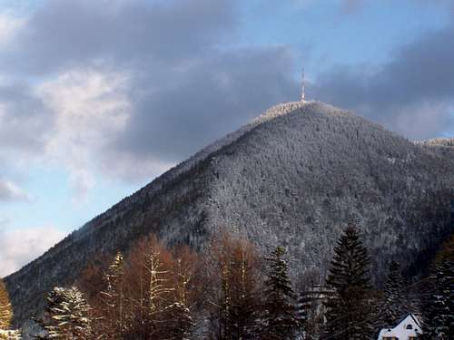
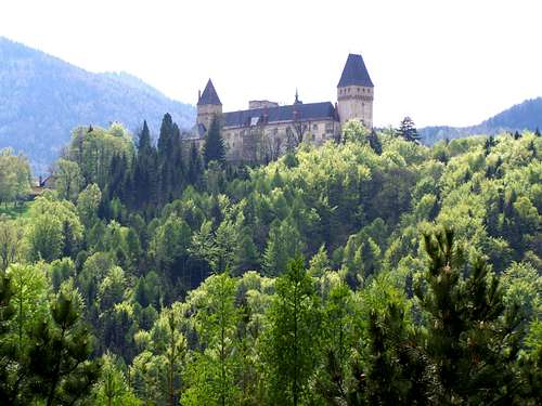
Sonnwendstein is the dominant mountain above Semmering Pass. The summit is 2 km east to the pass 540 meter above the highpoint of Semmering Pass. But Sonnwendstein is even more dominant when you arrive from eastern direction from the Vienna Basin to Semmering Pass. From Neunkirchen (on 370 m elevation) you can see well the contours of Sonnwendstein. Its summit is 1150 m higher than the plain below it.
The summit of Sonnwendstein is in Lower Austria, but only 1 km far from the border of Lower Austria and Styria. This border is anyway on the watershed of Drau and Danube. The watershed crosses the summits of two western sub-peaks of Sonnwendstein: Erzkogel (1504 m) and Hirschenkogel (1340 m).
Sonnwendstein is between the higher and better known mountains of Rax (2007 m, NE direction) and Stuhleck (1782 m, SE direction). Topographically it belongs more to the mass of Stuhleck than to Rax: its key col to Stuhleck is higher than its key col to Rax.
Rax and Stuhleck are different worlds: Rax is part of the Northern Limestone Alps, while Stuhleck is the highest mountain of the crystallic range of Fischbacher Alps. Sonnwendstein is built of limestone (or dolomite), so despite topographically it belongs to Stuhleck, its nature makes it more the relative of the Rax-Schneeberg Group.
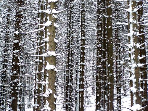
Limestone outcrops are visible on the northern face of the mountain. Otherwise most of the mountain is covered by spruce forest, except for some areas on the top of the mountain and along the ridges.![View of Sonnwendstein from Semmering Pass]()
View from westThere are really a lot of objects on the summit of Sonnwendstein.
On the highest point there is a chapel, a radio transmitter station and a lookout point. The chapel The radio transmitter station was built by ORF in 1957. The chapel was built in 1935-1936, and it was used by the Luftflottenkommando in WWII.
The lookout point gives good panoramic view to west, north and to east. The most notable mountains that can be seen:
- West: Tratenkogel (also called Drahte Kogel), 1565 m
- Northwest: Rax, 2007 m
- North: Schneeberg, 2076 m
- East: Grassberg, 1078 m - and the Pannonian plains behind it
The tourist house called Pollereshütte is just below the summit, on 1481 m elevation.
The usual element of peaks in Austria - the summit cross - is not here but on the sub-peak Erzkogel.![Dense forest]()
Dense forestOn Sonnwendstein and at Semmering there is a very wide range of opportunities for outdoor activities
Hiking
There are more than a dozen hiking trails on Sonnwendstein. I list here a few of them:
- Gebirgsjaegersteig: From Maria Schutz directly to the summit of Sonnwendstein. 760 m elevation gain, 2 hours, medium difficulty
- Almsteig: From Maria Schutz via Greis to the summit of Sonnwendstein. 760 m elevation gain, 2.5 hours, medium difficulty
- Waldweg: From Maria Schutz to Semmering, on the northern slopes of Sonnwendstein. 260 m elevation gain, 1.5 hours, medium difficulty
- Sonnwendsteinweg: From Lichtensteinhaus (Hirscehkogel) to Sonnwendstein, on the forest road. 270 m elevation gain, 2 hours, light
- Hochalmweg: From Lichtensteinhaus (Hirscehkogel) via Erzkogel to Sonnwendstein. 270 m elevation gain, 2 hours, medium difficulty
- Kammweg: From Lichtensteinhaus (Hirscehkogel) via Erzkogel to Sonnwendstein. 270 m elevation gain, 2 hours, medium difficulty. It’s a variant of Hochalmweg
- Schwarzenbergweg: From Maria Schutz via Göstritzgraben to the summit of Sonnwendstein. 760 m elevation gain, 3 hours, medium difficulty
Skiing
Zauberg-Semmering ski resort, with 14 km long ski runs operating both day and night and having an area also for snowboarders and free-style skiers
Biking
a) Road cycling to Semmering
b) Zau[:ber:]g Bike Park. The bike park is ont he slopes of Hirschenkogel (1340 m), amongst others with the following trails:
- Monsterroller line
- Freeride area
- Downhill trail
- Slopestyle park![Castle Wartenstein]()
Castle Wartenstein
Burg Wartenstein
This mountain castle is 5 km far from the summit of Sonnwendstein. It was built from the 12th century on a 765 meter high hill. In the 19th and 20th century this castle was owned by the world-famous Lichtenstein family
The church of Schottwien
A beautiful church of gothic style built in the 14th-15th centuries, at the foot of Sonnwendstein
Pilgrim-churh in Maria-Schutz
Maria-Schutz is a small resort on the northern slope of Sonnwendstein. It’s famous about a big Pilgrim-church of baroque-style built in 1728. The church is the starting point of 5 hiking trails
Semmering Railway
16 viaducts and 14 tunnels built between 1848-1854. UNESCO World Heritage site.
Historic hotels and villas from the era of Austro-Hungarian empire, from the 2nd half of the 19th century and from the beginning of the 20th century.
![Schober Hütte]()
Schober Hütte
The nearest camping site is Europa Camping in Langenwang, 16 km far from Semmering Pass.
Polleres Hütte on the summit of Sonnwendstein![Schneeberg in the clouds]()
Schneeberg in the distanceOnline map here
Weather-information and web-cam
Nearest higher peak: Stuhleck (1782 m)
Prominence: 250 m
Semmering Pass
One of the viaducts of the S6 highway
Semmering Pass is one of the two most important Alpen passes connecting Lower Austria with Styria. Highway S6 passes here, with huge traffic of 12500 car units per day. S6 highway has 2 x 2 lanes, and 6 double tunnels had to be built in this mountainous environment. The longest tunnel is the Ganzstein Tunnel with 2.1 km length.
Even more famous the Semmering Railway. It’s the first mountain railway of Europe, built between 1848 and 1854, connecting Vienna with Trieste. It’s a UNESCO World Heritage site.
Overview
Erzkogel
Sonnwendstein is the dominant mountain above Semmering Pass. The summit is 2 km east to the pass 540 meter above the highpoint of Semmering Pass. But Sonnwendstein is even more dominant when you arrive from eastern direction from the Vienna Basin to Semmering Pass. From Neunkirchen (on 370 m elevation) you can see well the contours of Sonnwendstein. Its summit is 1150 m higher than the plain below it.
The summit of Sonnwendstein is in Lower Austria, but only 1 km far from the border of Lower Austria and Styria. This border is anyway on the watershed of Drau and Danube. The watershed crosses the summits of two western sub-peaks of Sonnwendstein: Erzkogel (1504 m) and Hirschenkogel (1340 m).
Sonnwendstein is between the higher and better known mountains of Rax (2007 m, NE direction) and Stuhleck (1782 m, SE direction). Topographically it belongs more to the mass of Stuhleck than to Rax: its key col to Stuhleck is higher than its key col to Rax.
Rax and Stuhleck are different worlds: Rax is part of the Northern Limestone Alps, while Stuhleck is the highest mountain of the crystallic range of Fischbacher Alps. Sonnwendstein is built of limestone (or dolomite), so despite topographically it belongs to Stuhleck, its nature makes it more the relative of the Rax-Schneeberg Group.
Limestone outcrops are visible on the northern face of the mountain. Otherwise most of the mountain is covered by spruce forest, except for some areas on the top of the mountain and along the ridges.
The peak
View from west
On the highest point there is a chapel, a radio transmitter station and a lookout point. The chapel The radio transmitter station was built by ORF in 1957. The chapel was built in 1935-1936, and it was used by the Luftflottenkommando in WWII.
The lookout point gives good panoramic view to west, north and to east. The most notable mountains that can be seen:
- West: Tratenkogel (also called Drahte Kogel), 1565 m
- Northwest: Rax, 2007 m
- North: Schneeberg, 2076 m
- East: Grassberg, 1078 m - and the Pannonian plains behind it
The tourist house called Pollereshütte is just below the summit, on 1481 m elevation.
The usual element of peaks in Austria - the summit cross - is not here but on the sub-peak Erzkogel.
Activities
Dense forest
Hiking
There are more than a dozen hiking trails on Sonnwendstein. I list here a few of them:
- Gebirgsjaegersteig: From Maria Schutz directly to the summit of Sonnwendstein. 760 m elevation gain, 2 hours, medium difficulty
- Almsteig: From Maria Schutz via Greis to the summit of Sonnwendstein. 760 m elevation gain, 2.5 hours, medium difficulty
- Waldweg: From Maria Schutz to Semmering, on the northern slopes of Sonnwendstein. 260 m elevation gain, 1.5 hours, medium difficulty
- Sonnwendsteinweg: From Lichtensteinhaus (Hirscehkogel) to Sonnwendstein, on the forest road. 270 m elevation gain, 2 hours, light
- Hochalmweg: From Lichtensteinhaus (Hirscehkogel) via Erzkogel to Sonnwendstein. 270 m elevation gain, 2 hours, medium difficulty
- Kammweg: From Lichtensteinhaus (Hirscehkogel) via Erzkogel to Sonnwendstein. 270 m elevation gain, 2 hours, medium difficulty. It’s a variant of Hochalmweg
- Schwarzenbergweg: From Maria Schutz via Göstritzgraben to the summit of Sonnwendstein. 760 m elevation gain, 3 hours, medium difficulty
Skiing
Zauberg-Semmering ski resort, with 14 km long ski runs operating both day and night and having an area also for snowboarders and free-style skiers
Biking
a) Road cycling to Semmering
b) Zau[:ber:]g Bike Park. The bike park is ont he slopes of Hirschenkogel (1340 m), amongst others with the following trails:
- Monsterroller line
- Freeride area
- Downhill trail
- Slopestyle park
Historic buildings and constructions
Castle Wartenstein
Burg Wartenstein
This mountain castle is 5 km far from the summit of Sonnwendstein. It was built from the 12th century on a 765 meter high hill. In the 19th and 20th century this castle was owned by the world-famous Lichtenstein family
The church of Schottwien
A beautiful church of gothic style built in the 14th-15th centuries, at the foot of Sonnwendstein
Pilgrim-churh in Maria-Schutz
Maria-Schutz is a small resort on the northern slope of Sonnwendstein. It’s famous about a big Pilgrim-church of baroque-style built in 1728. The church is the starting point of 5 hiking trails
Semmering Railway
16 viaducts and 14 tunnels built between 1848-1854. UNESCO World Heritage site.
Historic hotels and villas from the era of Austro-Hungarian empire, from the 2nd half of the 19th century and from the beginning of the 20th century.
How to get there
The easiest approach is from Vienna, on the highway A2 and S6 directly to Semmering Pass. Only 90 km distance and 1 hour 15 minutes by car.Red Tape
No red tapeCamping
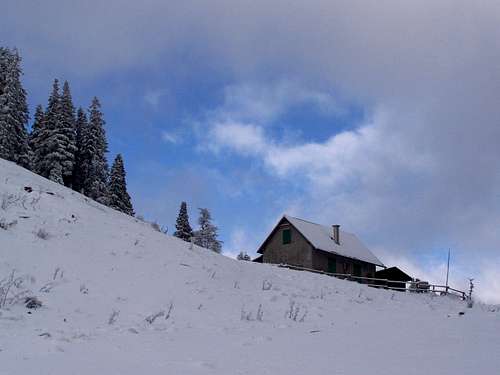
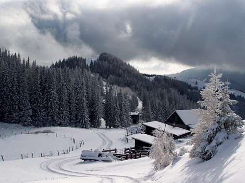
Schober Hütte
The nearest camping site is Europa Camping in Langenwang, 16 km far from Semmering Pass.
Polleres Hütte on the summit of Sonnwendstein
Useful links
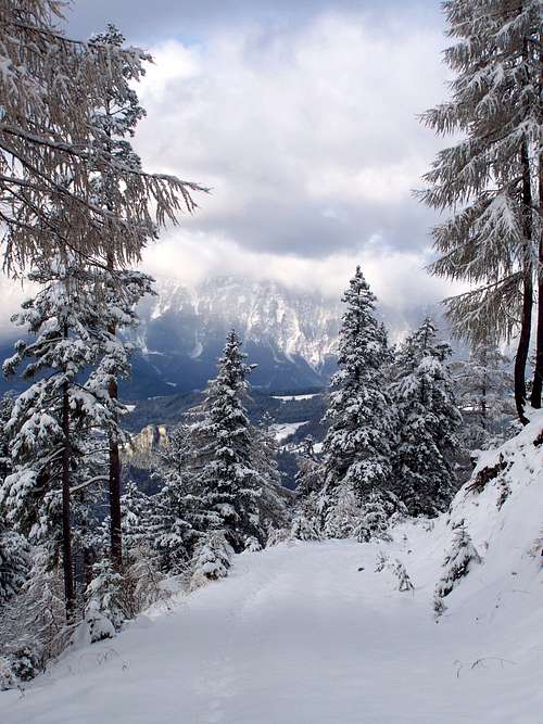
Schneeberg in the distance
Weather-information and web-cam