
-
 5874 Hits
-
 76.66% Score
-
 7 Votes
|
|
Route |
|---|---|
|
|
37.14423°N / 118.54974°W |
|
|
Hiking |
|
|
Spring, Summer, Fall, Winter |
|
|
Half a day |
|
|
Class 1, Class 2 |
|
|
Overview: Bang for the Buck
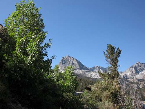
Cloudripper (L) and the obvious Chocolate Peak
This route is probably the easiest way to climb Chocolate Peak. It is very scenic along its entire length. The ridge portion of the route is Class 2.
The subtitle above refers to the fact that the relative ease of reaching this peak from the trailhead, coupled with the magnificent views afforded from a sub-12,000 foot Sierra Nevada peak, provides the hiker with unparalleled value for minimal effort.
The route is about 4 miles one way with about 2,000 feet of gain.
Getting There
From Bishop, off of Highway 395, take West Line Street (Hwy 168) going west. There is a prominent sign at the corner providing the mileage to South Lake (22 miles), North Lake and Lake Sabrina. After approximately 15 miles on Hwy 168, you will come to the signed turn-off for South Lake. Go left (this is South Lake Road) and proceed about 7 miles to the end of the road and the Bishop Pass trailhead at South Lake. Here, there is overnight parking and day parking and the parking areas are ample.
 Hurd Peak (12,237') seen from Bishop Pass Trailhead
Route Description
From the parking area, take the signed Bishop Pass Trail. The well-maintained and scenic trail climbs from South Lake up its eastern side. At 0.8 miles, there is a signed junction. The trail to the right goes to Treasure Lakes. Stay left. In another 0.6 miles, you will come to a second signed junction where the trail to your left goes to Marie Louise Lakes and Inconsolable Lake. Stay to the right on the trail towards Bishop Pass for another 0.5 miles and you will encounter a third signed junction at 10,720’ elevation. Here, the trail dropping down to the left goes to Bull Lake and the Chocolate Lakes. This is the trail you want.

Go toward Bull Lake
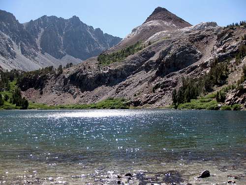
The trail takes you around the eastern side of Bull Lake, then along the western side of the smallest of the three Chocolate lakes, the eastern side of middle Chocolate Lake, and finally along the western side of the largest of the Chocolate lakes (generally referred to as “Upper Chocolate Lake”). It is approximately 1.5 miles from the Bull Lake/Chocolate Lake junction to Upper Chocolate Lake. All along the trail you have superb views of your destination, Chocolate Peak. To the east, 13,525 foot Cloudripper thrusts its pointed snout into the clouds.

Cloudripper (13,525') looking so close

Chocolate Peak seen from across Bull Lake
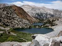
Chocolate Peak and the Chocolate Lakes seen from the southeast
Cloudripper (CL) and Chocolate Peak seen from across Bull Lake
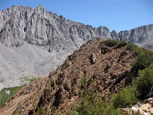
From Upper Chocolate Lake, continue as the trail ascends from the lake up to a saddle southeast of Chocolate Peak. From the saddle ascend the ridge heading north and slightly west. The route is Class 2 and it is a very pleasant scramble. Moving at just a moderate pace, it should take you no longer than 20 minutes to reach the summit from the saddle.

Me, my daughter Alicia, and my son Daniel, on Chocolate Peak's summit, 8.18.08
From the summit, marvel at the views of Long Lake, below to the west, and Hurd Peak above Long Lake; the Chocolate Lakes, below to the east, with Cloudripper looming further in the distance.
Red Tape
You need a permit for this trailhead if you are packing in over-night. One can either reserve one in advance for a $5 fee per person, or get a walk-in permit (free) after 11 a.m. on the day before you want to start. Permits can be secured at the White Ranger Station in Bishop.
Essential Gear
Except for winter, trail runners are perfectly adequate for this route. In the winter, with snow cover, equip yourself appropriately.
External Links
Inyo National Forest Home Page
Wilderness Permit Information, Inyo National Forest