
|
|
Route |
|---|---|
|
|
39.27500°N / 105.3672°W |
|
|
Steep Hike & Bushwhack |
|
|
Most of a day |
|
|
class 2+ |
|
|
Approach
RT 6 miles & 3,500-ft
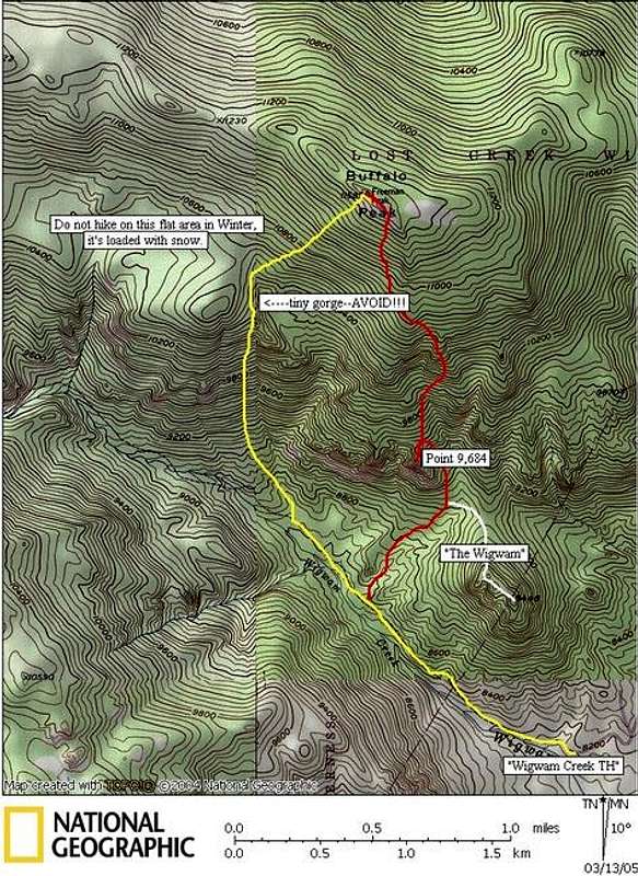
This is not the easiest route up Buffalo Peak, it may be the most difficult route. Refer to my route overview on the main page before attempting this route.
Route Description
The following route is marked in Red on the TOPO. Starting at the Wigwam Creek Trailhead at 8,160-ft hike 1 mile on the well-traveled Wigwam Creek Trail. En route, locate “The Wigwam” directly north and study it, this will be one of the few landmarks you occasionally see when descending the south slopes of Buffalo Peak. After one mile of hiking locate Buffalo’s steep south slope directly north. Leave the trail and whenever possible, study this slope, looking for the craggy summit 3,000-ft above you. The idea is to hike directly up the mountain, skirting any rock outcroppings or huge boulders. This slope is relentlessly steep for the first 1,650-ft. At about 10,380 ft, the slope relents a bit and you must negotiate a tiny gorge. This feature doesn’t really show well on the TOPO map. It is best to hike northwest around this terrain and not cross directly through it, the gorge is choked up with boulders and down fall.
Once passed the gorge, the last 900-ft is more of the same steep hiking. When you finally see the summit crag, hike east to its very east end and locate the weakness up through the cliffs. The scrambling here is easy class 3 for just a few feet. Enjoy the summit ride and views.
If you’re up for more adventure, try descending the direct south slope. This spooky route descends down through all of the giant boulders and rock outcroppings. This route is marked in yellow on my TOPO map. The following is a brief description of that descent.
For the descent, head down the southeast ridge, keeping an eye out for any cliffed out portions of the slope. The idea here is to keep going east and down and if you come to any difficulties, skirting them on one side or the other should work. Keep an eye out for “The Wigwam,” this landmark will help keep your sense of direction on target. If you have time, make a quick class 3 ascent up Point 9,640-ft (refer to TOPO). It’s a huge exposed crag that protrudes from the steep south slope of Buffalo. The view of “The Wigwam” is very cool here.
Essential Gear
TOPO, Compass and GPS
Miscellaneous Info
If you have information about this route that doesn't pertain to any of the other sections, please add it here.