
-
 2021 Hits
-
 78.1% Score
-
 9 Votes
|
|
Route |
|---|---|
|
|
50.05988°N / 115.20783°W |
|
|
Download GPX » View Route on Map |
|
|
Mountaineering |
|
|
Summer, Fall |
|
|
One to two days |
|
|
PD |
|
|
Class 4 |
|
|
Overview
This is the normal route up mount Harrison. It can be done in one long day, of perhaps 12 hours, or two more casual days.
Getting There


Take the White Swan Forest Service Road from Canal Flats, or the Bull River FSR from Bull River or Fernie, to the Harrison Creek FSR, then follow it for 9.2km to a clearing when it bends back east. The trailhead is not obvious. We enlarged the cairn as we left, but if it goes missing, see the picture on the right for its location. Plenty of space to camp but no water when we were there.
In October 2020, the Bull River FSR was in good condition, and it took us about two hours from both Fernie and Bull River to the trailhead. High clearance (as well as not being worried to leave some scuff marks on the car paint) was necessary for the last 4 or 5 km, which could also be walked or biked.
I am not sure how relevant the route would be in winter or spring, but the shortest ski or snowmobile approach would be by Koko Claims from Elkford.
Route Description

From the cairn, head due west for 250 meters of easy to moderate off-trail, until hitting avalanche debris and a creek. A fairly obvious path then appears (at least in late 2020 with low water, unlike the wild bushwhack that has been reported previously). It crosses the creek twice then re-enters the forest. At the next clearing, after a steep climb, it is possible to follow either a path or the creek bed. We found the latter to be easier when dry.


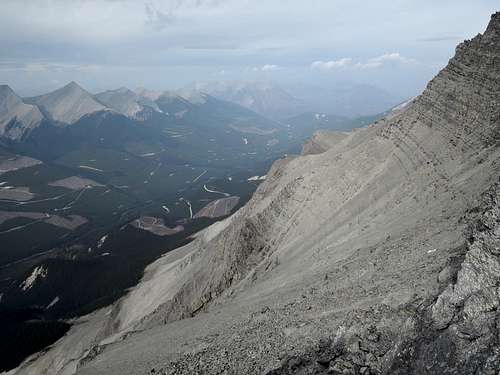
At some point, both will join a series of taluses on climber’s left. Tread the line between the taluses and the bush. A few potential camp spots safe from rockfall are soon to be found, then two waterfalls, which were the last liquid water source for us. Admire Harrison’s north face, and head southwest toward the Harrison-Folk col. Near the col, aim slightly left (south) toward a shoulder higher up (unless one plans to camp at the col).
From there, three bowls are to be traversed. The first is easy with a packed path. The second is trickier, as the ground is loose and there is no more continuous path; it will take caution and time. The third is short and not as loose or steep, but there may be some scramble to get on and off it depending on the exact elevation one gains the ribs around it (see the GPS track for ok spots).
 |
 Scramble when too low into the third bowl, around 2900m. |
 |
The usual final ascent couloir then comes into view. Pick your poison: in the gullies, the rocks are looser; on the ribs, there are YDS 4 scrambles. I preferred the ribs. Unless the couloirs are filled with snow, stay close to each other as you will trigger rockfall. At last the terrain flattens and the summit is soon reached.
The attached GPS track was accurate for the path in October 2020 below treeline and for the first bowl. Otherwise, it was the best line we found.
 |
 |
 |
Essential Gear
Early to mid-summer: crampons and ice axe, and possibly rope and some protection for the final gully.
Late summer to early fall: hiking boots, poles and helmet.
My opinion
I found the traverse of the second bowl to be more intimidating than some online trip reports suggest. While it is not as steep as the final gully, I found it to be more slippery, with the risk of taking the slide of a life. Otherwise, the route is pretty straightforward. Just check the GPS during the initial off-trail part.