
|
|
Route |
|---|---|
|
|
40.34350°N / 105.776°W |
|
|
Hike w/ difficult navigation |
|
|
Most of a day |
|
|
Class 2 |
|
|
Approach
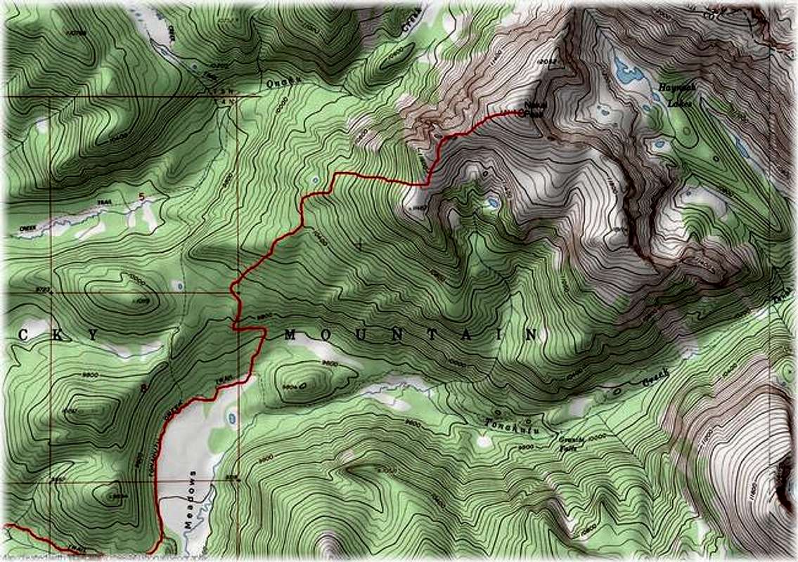
Round Trip-12.5 miles and 3,600-ft
Starting at the Green Mountain Trailhead at 8,790-ft, hike a good trail 2 miles to Big Meadows. From here directly northeast, you can’t see any of Nakai’s upper alpine area, including its summit, just Nakai's tree covered lower southwest slopes.
From here, leave the Green Mountain Trail and go north on the Tonahutu Creek Trail. The trail will travel the outskirts of Big Meadows. At the end of the meadow the trail makes a sudden turn to the south (refer to topo.) From here, say good-bye to the comforts of the trail and say hello to the tree covered, southwest slope of Nakai Peak. NOTE: If climbing in March-May, you might want to consider just leaving the Tonahutu Trail and hiking out onto the snow-covered Big Meadows. During these months the snow is more consolidated and makes for simple hiking with limited post holing, especially early in the day. Be warned; later when things start heating up have a different plan for the return trip. This meadow would be a bad place to get stuck in a spring post holing affair.
Route Description
Once leaving the trail hike directly north to about 10,000-ft., then veer northwest to about 10,400-ft. From 10,400-ft, hike east to a flat spot above tree line just north of Point 11,467-ft. From the Big Meadow to tree line is about 2,000 vertical feet in about 2 miles.
Once above tree line on Nakai’s broad southwest ridge the route becomes class 1 with easy navigating. Hike directly north to Point 11,801 and continue another .5 mile to Nakai’s 12,216-ft summit. Note: If climbing in March-May this ridge presents a safe winter climb if you stay directly on the ridge crest. Veering to the right too much gets you in avalanche terrain.
Descend your ascent route.
Essential Gear
compass/topo map