
-
 6550 Hits
-
 84.82% Score
-
 19 Votes
|
|
Area/Range |
|---|---|
|
|
46.33949°N / 14.43928°E |
|
|
Hiking, Mountaineering, Scrambling, Canyoneering, Skiing |
|
|
Spring, Summer, Fall, Winter |
|
|
1853 ft / 565 m |
|
|
Introduction
This page and the page of Tolsti vrh were created because the page of Storžič, which has been on SP since 2002, became too big. As these are my home mountains, I want to describe them a bit more in detail.
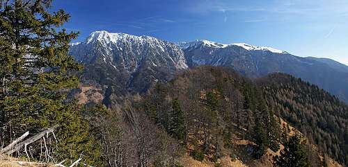
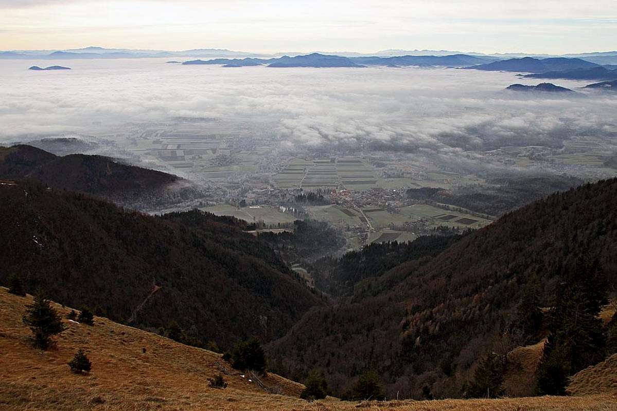 The view from Zaplata over Gorenjska plane
Overview
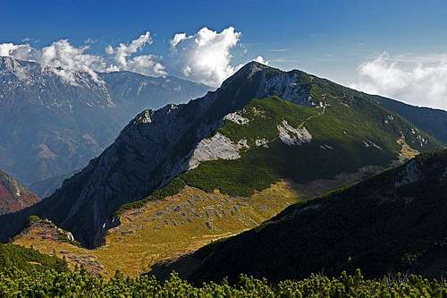
 On Srednji vrh
 On Srednji vrh
East of Storžič a not so high, but also quite interesting mountain group is rising. There the main ridge goes more in the SE direction, but also north of it a few quite remote summits stand. This small group is named by its highest summit Srednji vrh group. Its summits are not so frequently visited as Storžič itself, but in the recent years a bigger and bigger flow of hikers is coming from the southern side. As the whole Storžič range, also the summits in the main ridge of Srednji vrh group are rising just above the plane of Gorenjska, so the views from them are very nice. But the northern side of the group is surprisingly rarely visited. In those rocks and ravines you will for sure not meet a visitor, be it in summer or winter time. Rare passages are known only to hunters.
Geography
 Srednji vrh group from the E-SE
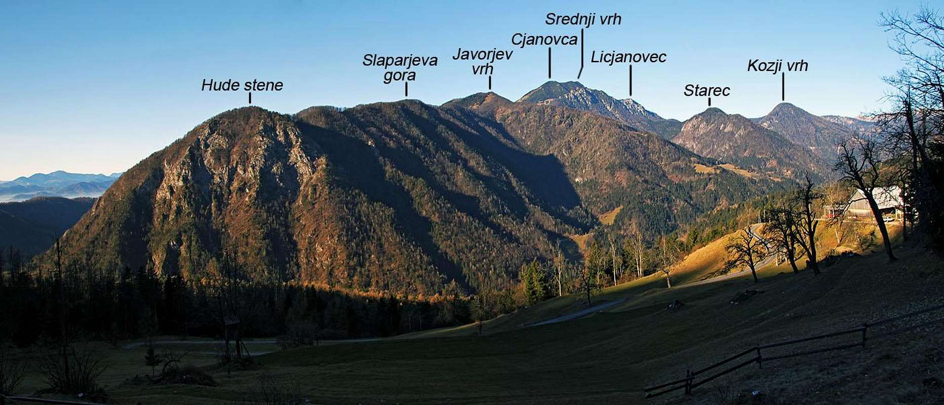
The eastern and southeastern border of our group goes by the valley of river Kokra, which is delimiting the groups of Storžič and Kočna/Grintovec. On the south, the summits are lowering on Gorenjska plane. The western border goes by two valleys, delimiting our group from the narrow massif of Storžič. On the southern side that is the valley of Belica creek and on the northern the valley of Reka creek. By these two valley also the geological fault runs. On the SE, above the knee of Kokra, the first summit, which just reaches above the tree line, is Javorov vrh, 1435 m. Just above the Kokra knee there is the summit of Hude stene, 1208 m, then a bit higher Slaparjeva gora, 1237 m, and finally Javorov vrh, From the south another ridge comes up - with Baba, 1129 m, and Potoška gora, 1276 m. In its lower part the ridge of Potoška gora lowers towards the SW and on it there is the famous Sv. Jakob church. South of Javorov vrh, there is the valley of Čemšeniški potok (creek), with a mountain hut and marked path.
 Srednji vrh from Mali Grintavec. Below is Dolga Njiva valley.
From Javorov vrh the main ridge continues towards the NW, to the summit of Cjanovca, 1817 m. NE of this ridge the valley of Lobnica creek lies. SW of this ridge the valley of Bistrica creek lowers towards Preddvor town. Both these valleys are very lonesome. With Cjanovca, the highest part of our group begins. The southern slopes of it are called Zaplata (=patch), we'll describe why a bit later. Just a bit further towards the NW of Cjanovca, there is already the highest summit - Srednji vrh. From it, the main ridge continues towards the NW. The next summit is Mali Grintavec, 1813 m. While the northern face of Srednji vrh is rocky, wild and rugged, towards the SW a small plateau-like landscape stretches. On the west it ends in a nice high valley, called Dolga Njiva. There is a hunters hut too. So, we already reached into the western part of our group. For it long side ridges are characteristic, descending from the north towards the south. Just west of Dolga Njiva, from the summit of Mali Grintavec the ridge of Lanež is descending southwards. It is rocky and quite hard to be ascended. Its lower part is called Kozjek, 1101 m, hosting another hunters hut. West of Lanež ridge there is the valley of Suha (=dry valley), in which a water source appears quite low. West of Mali Grintavec there is in the main ridge Mačensko sedlo (=saddle) and then soon Bašeljski vrh, 1744 m. From this one another side ridge descends towards the south. It lowers on a terrace, where the big Dom na Kališču stands, 1535 m. Below it is a small meadow of Kališče and then the ridge continues down through the woods. Finally, west of Bašeljski vrh there is Bašeljski preval (=saddle), where the narrow massif of Storžič begins.

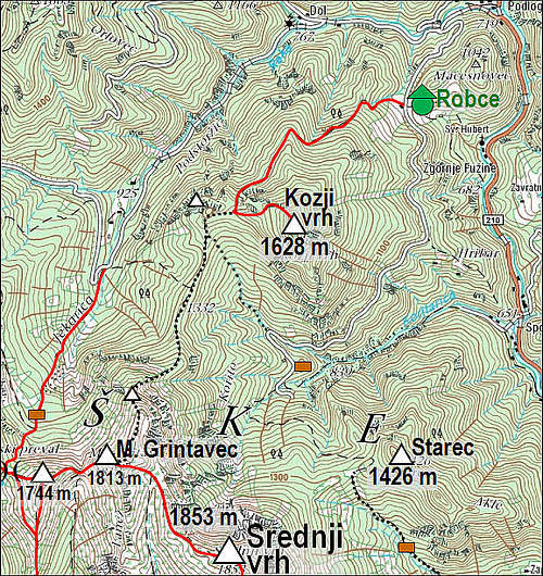
North of the main ridge we already mentioned the valley of Lobnica. North of it there is a forested summit of Starec, 1426 m, with its SE fore-summit, named Akle, 1380 m. Further to the north from Korito valley-end the creek of Koritarica flows towards the east, into Kokra. It's valley is wild and hardly passable. Finally, north of Koritarica a stand-alone summit of Kozji vrh rises above the tree line, 1628 m. Due to its solitude and interesting views it is a valuable goal of a hike. A few rocky towers W-NW of it are called Turni, 1432 m. Kozji vrh is connected with the main crest by a side ridge, which from Mali Grintovec descends over the summit of Licjanovec, 1733 m, towards the north.
Summit Views
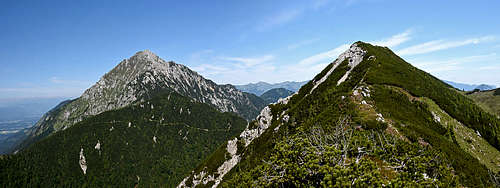
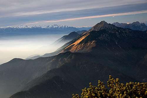
 Towards Julian Alps
 Kočna from Srednji vrh
From all summits in the main ridge we have very nice views towards the south, across the Gorenjska plane. In the distance on the west we see Julian Alps, nice is also the view on the nearby and much higher Storžič. Towards the north the views are a bit obscured by higher mountains above Jezersko. Towards the NE very interesting are the views on the highest part of Kamnik and Savinja Alps, with Kočna in the first row.
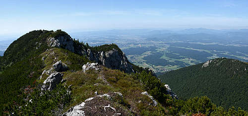
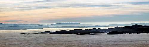 Southern views from Zaplata
Hudičev boršt
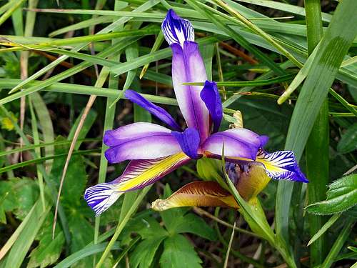 Iris graminea
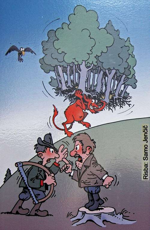
The grassy southern slopes of Cjanovca summit are called Zaplata. Looking these mountains from the south one immediately notices a strange rectangular patch (patch=zaplata) of an isolated forest there. It is now protected as a natural reserve. In its lower part there's a valuable water source and close by also a mountain hut (Lovska koča na Zaplati, 1324 m). And there's a typical legend how the forest came there... Two farmers down in the valley were having an angry dispute who was the owner of a nearby forest. They couldn't settle the issue, dirty words, calling the Devil, started to appear in the quarrel and ... the Devil did suddenly show up. He took the forest, which was the object of the dispute, and, carrying it on his shoulders, ran up on the mountains. It was noon, when he was in the middle of the grassy slope of Cjanovca. Then the bell of the nearby Sv. Jakob church rang. The Devil immediately lost his power, had to leave the forest on that place and disappeared. From that times the forest is called Hudičev boršt (Devil's Forest) and the mountain is called Zaplata.
What To Do There?
The mountains of Srednji vrh are almost exclusively hiking mountains. Skiing is possible on various sides, but not very popular, because the lower parts are less suitable. In the beginning of alpinistic skiing there were attempts to ski through the northern ravines, but today almost nobody repeats them. The canyon of Koritarica has quite an importance for ice climbing - in winter there are a few attractive waterfalls.
Historical Places
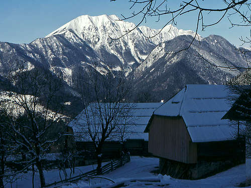
 Sv. Miklavž above Mače
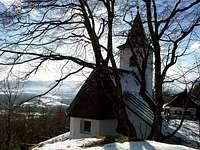 Sv. Jakob
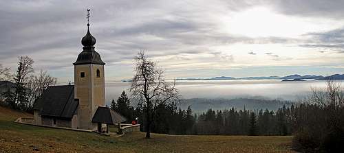
By the valley of Kokra river always an important trade route went. At its mouth, near Preddvor, four castles were guarding it, the oldest was built even in the 12th century. But archeological evidence revealed even much older settlements on the nearby hills. West of Sv. Jakob church a settlement (refugium) from late Antiquity was found. Also the cute church itself originates already from romanic and gothic era. Cute is also the church of Sv. Nikolaj, above Mače. It was first mentioned quite late, in the 16th century and is famous by its renaissance cyclus of frescoes.
Getting There
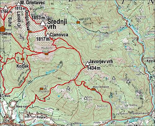
View Storzic Trailheads in a larger map
We can ascend on the summits of Srednji vrh group from almost all sides, but the southern trailheads prevail. Here is the list and the map of the main trailheads, reachable by car:
- The valley of Belica, 815 m. We drive there by a mountain road from Bašelj through Laško hamlet. For Kališče and western summits.
- Bašelj, 590 m. For Kališče and western summits.
- Mače, 600 m. Parking just above the village or higher in Suha valley, 800 m. For western summits and for Zaplata.
- Above Nova vas near Preddvor, 500 m. For Bistrica valley, Sv. Jakob and further on.
- Potoče above Preddvor, 540 m. For Sv. Jakob and further on.
- Spodnja Kokra, 552 m. For Čemšenik valley and Javorov vrh.
- Podlebelca, 600 m. For Javorov vrh.
- Lobnica valley, 900 m. For the valley and above it.
- Spodnje Fužine, 651 m. For Koritarica valley and above it.
- Kanonir / Reka valley, 725 m. For Kozji vrh.
- End of the road in Reka valley, 1000 m. For western summits.
Routes
 Cjanovca descent
 On Zaplata S slopes
Hikes And Easy Scrambles
The tour of my personal choice is the combination of below tours #5 and #6. We usually park above Mače, ascend on Kozjek ridge, further up on Dolga njiva and go by the beautiful valley just on the main ridge. Then we turn right and ascend Srednji vrh by the main ridge. From there we continue on Cjanovca, but from there descend directly by its broad, grassy slopes to Hudičev boršt. That's a wonderful feeling of breadth and freedom! Finally we return in Mače.
1. To Kališče hut
Kališče meadow was inhabited already hundreds of years ago, but today the popular mountain hut stands on a terrace some 50 m above it. All the main approaches are easy (T2), 2-3 hours. The following main paths reach the hut:
 Winter woods
a. From the parking place above Mače, 600 m, we hike up by the road into Suha creek valley. Near the lower station of materil cable way the marks (and cart-road) turn a bit left, so we hike up through the woods. Till the flat part of the trail, where the cart road ends we can also get by the old marked trail which deters left from Suha creek and goes more by the southers slopes. On the flat part the joint trail goes horizontally through a dense forest and reaches the forested slopes of Kališče hill. There, the path goes up in several broad turns, finally exiting on the ex alpine meadow (that is Kališče). The mountain hut is still some 50 altitude meters up on a panoramic place.
b. From Bašelj, 590 m. In the upper part of the village there's an inscription directing us towards the mountain hut. The trail goes first right, then left up over the forested slopes. Higher it turns over into the slopes of Belica creek, even descends a bit, but soon turns right again and joins the path from Mače at the end of the horizontal section.
c. From Belica creek valley, 815 m. Above Laško village we can drive by a steep road till some 750 m, where below Sv. Lovrenc church there's a parking place. Again, some people drive even further up into the valley of Belica creek. From the parking place we hike up by the mountain road, pass the Gradišče hill (archeological site), and reach the creek bed. There, one path goes left to the ex Partisan hospital (from the World War II), but our path crosses the creek and starts ascending over the slopes on the other side. After several turns through the woods up the path reaches Kališče meadow. Several other approaches to the mountain hut are possible, for example: From the lower station of the material cable way directly right up and on the side ridge of Kozjek, then by it to the horizontal path which comes on Kališče from the east, from below Zaplata.
2. Kališče - Bašeljski vrh
 flow - Bašeljski vrh
The most direct path ascends on this less important summit directly from the south. From the hut we go a few minutes by the main path towards Storžič, on the place where this path starts crossing the western slopes of the ridge, we simply continue by the ridge. The path winds through pine bushes and brings us on top in some 30 minutes. T2. We can return by the same route, we can descend westwards on Bašeljski preval (=saddle), 1631 m, and return on Kališče, or we can descend eastwards on Mačensko sedlo, 1622 m, and return on Kališče by crossing the eastern slopes of the ridge.
3. Kališče - Mali Grintavec
 Branko - Mačensko sedlo
The ascent on the next summit towards the east is only some 10 minutes longer than on Bašeljski vrh. North of Kališče hut we take the marked path which crosses the eastern slopes of Bašeljski vrh ridge. It brings us with only a few ups and downs first on Mačensko sedlo, 1622 m, from where we continue eastwards on top. Easy (T2), 45 min. Of course we can get there also from Bašeljski vrh.
 Storžič from the ascent on Mali Grintavec
 We lost the best route in Suha
4. Mali Grintavec by Suha valley
This is a rarely used, unmarked approach. From the parking place above Mače, 600 m, or the one higher in Suha valley, 800 m, we go by the broad valley northwards. Marks lead us by a cart road, but when it branches, we take the left, unmarked branch. After the cart road ends, we continue by a weak path, which almost gets lost in the forested valley. In the middle of the valley we cross the marked path, which connects Kališče and Hudičev boršt, and continue further northwards. Keep by the valley-bottom and follow rare cairns! So we reach Mačensko sedlo, where we turn right and go on top. Easy, but unmarked (T2, carefully with orientation!), 3 h 15 min (or 2 h 45 min).
5. Mali Grintavec by Lanež ridge
The ridge of Lanež is actually the south ridge of Mali Grintavec, separating the high valley of Dolga Njiva (on the east) and the deep, dry valley of Suha (on the west). In the recent years along the whole upper part of the ridge a trail was cut through dwarf pines, allowing a medium demanding hike (T3). The lowest ascent comes on the ridge from the valley below the hut on Dolga Njiva. Then the trail goes on the summit of Lanež, 1709, further on the summit of Kobila, 1777 m, and finally on the Mali Grintavec, 1813 m. If you don't want to traverse the whole ridge, you can walk up by the grassy valley of Dolga Njiva, half way up turn left and ascend by an easy, almost pathless clearing up on the rige. You gain it just south of the summit of Kobila.
6. Mače - Kozjek - Srednji vrh
 Kozjek ridge
This tour has many variants and from the beautiful Dolga Njiva meadow we can visit more summits. From Mače, 600 m, we go by the road into Suha valley. Above the parking place near Kališče material cableway the cart road branches and we take the marked right branch. The main marked path goes towards the NE. In the upper part of the valley it enters dense woods and then crosses the slopes right, soon reaching the distinct ridge of Kozjek. A hunters hut is just a bit lower on the nice ridge. The other option to get on Kozjek is more beautiful. Soon after the cart road branches (on some 960 m) we keep by a good path right, below distinct walls in the woods. So we soon reach a saddle south of Kozjek ridge and then go northwards by the ridge itself. This path is steep, narrow and requires some additional care (difficulty T3). From above the hunters hut we continue by the Kozjek ridge, until the marked path starts crossing by its eastern slopes. Before reaching the bottom of the distinct dry valley, from the right another marked path joins and later towards the left the marked path to Kališče deters. But we continue straight, cross the ravine and continue a few more minutes eastwards. There in the middle of a forested slope (on 1300 m) the marked path to Dolga Njiva deters left. Now we again go steeply up. In many turns the path brings us into the lower part of Dolga Njiva meadow, where on 1575 m a private hut stands. Till here 3 h (or 2 h 30 min), easy (T2). From there we have the following options:
a. On Lanež ridge. In the slope opposite to the hut we find a hunters path (its start is hidden) which brings us on the ridge of Lanež. But its highest part is more to the north and the ridge is quite difficult for a hiker.
 On Mali Grintavec
b. On Mali Grintavec. We continue by the beautiful valley northwards. When reaching the saddle on the main ridge, 1720 m, we turn left and ascend on top. Easy (T2), 40 min.
 Srednji vrh from Mali Grintavec
c. On Srednji vrh by the NW ridge. By the above variant b on the saddle on the main ridge, 1720 m, then turn sharp right and along the main ridge on top of Srednji vrh. The summit part of the main ridge has a few ups and downs, so this is a variant, much longer than d below. Easy (T2), 1 h 10 min.
d. On Srednji vrh across its S slopes. That's the direct, but less attractive ascent. From the hut we continue towards the E and then NE. Those slopes are not steep, in winter also very appropriate for skiing. A good marked path brings us on the main ridge SE of the summit, from there we go left on top. Easy (T2), 50 min. This is also the route of a ski tour.
e. On Cjanovca. That's a continuation of crossing the whole massif. By the above variant d we gain the main ridge and continue right on the nearby rounded summit of Cjanovca. Easy (T2), 45 min.
7. Mače - Hudičev boršt
This became recently a very popular ascent route to the rebuilt hut (Lovska koča na Zaplati, 1324 m). From the parking place above Mače, 600 m, we follow the forest road towards the NE (not in Suha valley!). It ascends gently, traversing the steep slopes above Bistrica valley. About half way up, on 841 m the marked path starts cutting road turns, ascending steeply northwards. It goes in the vicinity of a distinct ravine. On some 1100 m the path crosses the ravine and branches. The left branch goes on the ridge of Kozjek (see #5 above!), while we continue by the right branch. It still gains altitude in long, comfortable switchbacks, bringing us just on the lower edge of the famous Hudičev boršt. Then horizontally in a few minutes to the hut. Easy (T2), 2 h 10 min.
On the crossroads 841 m also a nonmarked path deters to the right off the road. That's the so-called #Konfinska pot" which encircles the whole valley of Bistrica. But already after a few meters a weak path branches directly up. It's very hard to follow, steep and quite demanding. It gains the road once more, then it continues by a steep rib directly up. It's goal is the so-called lookout point Below Zaplata, but meadows above are fairly easy to ascend (although steep). But even if you can reach the hut in Hudičev boršt directly, this shortcut is not recommended.
8. Hudičev boršt - Kališče
This is a connection path, very nice and popular with those who don't feel the urge to cross the massif by the main ridge (over the summits). It crosses the southern slopes of Cjanovca, then the upper, forested part of Kozjek ridge and finally the middle part of the dry Suha valley. Then the path ascends in switchbacks steeply over the eastern slopes to Kališče. Easy (T2), 1 h.
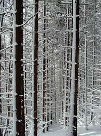
 Beech forrest in spring
9. Bistrica valley - Hudičev boršt
This is a wild, more demanding, pathless ascent trough a remote valley and then up to Hudičev Boršt. From Preddvor or Nova vas, 500 m, we enter the valley and follow the forest road After some 15 minutes we pass the climbing area (crags left above us). The we continue by the road, which becomes weaker, especially after crossing the (dry?) creek bed. On the place where side walls almost close the valley, the cart road ends. On the creek there are some cascades and passages are more demanding. We follow the creek up. When the ravine closes even more and becomes difficult, we try to find a steep passage out towards the left (northwards). Those woods are very steep and a lot of care is needed. We need to gain some 300 m of altitude before finally reaching the marked path, which connects Sv. Jakob church and Hudičev boršt. Then by it left to the hut, or by the main ridge up on the summit of Cjanovca and further on. The second option is not to follow the creek in its wild, upper part. At the end of the cart road we find a weak hunters path (cairn), which is steep, but easy. It goes by a ridge and later turns left in the upper creek bed, where it disappears. Continuing is pathless, but quite easy. Altogether: medium hard hike up (T4/T3), 3 h till the path on the main ridge.
10. Potoče - Sv. Jakob - Javorov vrh - Cjanovca
This is a very popular tour, especially the first part to the cute church of Sv. Jakob, 961 m. Every nice weekend many people ascend on the panoramic terrace below the church, where two private huts are standing. Today a mountain road reaches there (mountain biking!) but the marked path from Potoče village, 540 m, goes more straight, in many shortcuts. The ascent by the road is easy (T1), by the path a bit less (T2 or T3). The most beautiful route is by the steep W ridge (T3). 1 h 15 min.
 Ascending Javorjev vrh
 On Javorjev vrh
The continuing goes by the marked path towards the NE. It first ascends (15 min) to the crossroads, where we take the left branch (the right variant is a bit longer and goes over Potoška gora, 1276 m). Our path soon starts crossing the W and NW slopes. The ascent brings us on the broad northern ridge of Potoška gora. From the S the marked path over its summit joins and from the east the path from Čemšenik valley. Now we continue towards the NE. In a few minutes the path branches again. The right branch continues by the ridge, while the left path crosses the western slopes of Javorjev vrh. So, we continue by the forested ridge. Only the last minutes of ascent go over a grassy slope above the tree line. Easy (T2), from Sv. Jakob 1 h 15 min, from Potoče 2 h 30 min. The path, which continues towards Hudičev boršt and Cjanovca, first crosses the W slopes of Javorjev vrh, then gains the main ridge and follows it towards the NW. On good 1300 m it branches again. The left branch crosses the slopes and soon reaches the hut in Hudičev boršt. The right branch however continues by the main ridge steeply up. Higher it reaches above the tree line, winds through pine bushes and becomes more and more steep and also panoramic. The ridge slowly turns towards the left and so we climb on the summit of Cjanovca - to the bench and a small ciarn. Easy (T2), 3 h 45 min.
 Cjanovca from Javorjev vrh
11. Spodnja Kokra - Javorov vrh - Cjanovca
From the parking place we first go mostly by the mountain road to Dom Čemšenik (hut), 840 m. 50 min till there. Then we continue through the woods towards the NW. The path goes partly in the vicinity of a ravine, then right and over more steep, forested slopes up on the ridge between Potoška gora and Javorov vrh. Then further on as described in #9. Easy (T2). To Javorjev vrh 2 h 30 min, to Cjanovca 3 h 45 min.
12. Javorov vrh by the E-SE ridge


We start also this tour in Kokra valley, walk some 20 min into the valley of Čemšenik, but then on the crossroads go right and by the road to Kremsar farm (reachable also by car). From there we continue by a good path and later by a cart road towards the north. It brings us just below the main ridge, which we ascend near the summit of Hude stene (the option is also to keep right, ascend Škrbina promontory and then continue left by the whole ridge). Then we just follow the nice, mostly forested ridge. It can get narrow and requires some attention, but in dry season there are no real difficulties. Just before the summit grassy slopes start appearing. We go by the ridge, then cross the slopes towards the right and by the other, E-NE ridge up. Then we have only a few more minutes to the top. Orientation is easy (partly marked path), paths are narrow and not well beaten. Overall difficulty is T3, 2 h 45 min.
The recommended tour is: Kremsar farm (840 m) - Škrbina (1126 m) - Javorov vrh (1434 m) - Volčje jame saddle (1245 m) - Panoramska pot (trail) - Kremsar. 5 h.
 On the E-SE ridge On the E-SE ridge |
 The upper part of the E-SE ridge The upper part of the E-SE ridge |
13. Podlebelca - Javorjev vrh
We start this ascent in Podlebelca, in the valley of Kokra, 600 m. First we go up to Slapar farm, then by the road good 10 min more up and left by a non marked path. That one leads us by a shallow valley all the time towards the west. Above we cross an abandoned alpine pasture, then soon gain the side ridge and go by it on top. 2 h 30 min.
14. Lobnica - Starec
This tour is nothing special, but we can enjoy the solitude in Lobnica valley. In Kokra valley, at Povšnar, a mountain road deters left into Lobnica valley. Its end is on some 900 m. The continuing path is wide and good, but not marked. After gaining some 100 m of altitude we reach the hunters hut. Then we continue, all the time towards the NW. Ex Hajnriharjeva planina (alpine pasture), lying below the ridge, which connects Starec summit and Srednji vrh, is today already much overgrown. By a pathless terrain we gain that ridge and then right by it towards the summit of Starec. We need to overcome a few rocks, and fight the way through dense woods. The summit is still overgrown, but offers some interesting views around. Medium hard upper part (T3), 2 h.
15. Kanonir - Kozji vrh
Kanonir (=Gunman) is an old inn in the valley of Kokra, where the mountain road into Reka valley deters. By that road we drive westwards, but only till the first crossroads, 725 m. There we park, or perhaps try to drive by the steep left road (closed from July 20th till October 20th), which leads around the eastern side of Kozji vrh into Korito. The trailhead for Kozji vrh route is on Robci meadow, 1000 m. There we turn right, on the marked cart road. Above it turns into a marked path, which constantly crosses the northern slopes towards the right and up. The path is on many places steep and requires much additional care. Still higher the path reaches the rocky slopes of Kozji vrh, crosses a small scree field and then up on the forested saddle between the rocks of Turni (on the right) and Kozji vrh (on the left). There a weak, unmarked path goes right below Turni, but we turn left and follow the marked path, which starts a steep ascent by the slope of Kozji vrh. At first we still ascend through steep woods, higher the path approaches the rocky NW ridge. There it becomes even steeper and on some places quite exposed. That section requires a lot of care. The last part is then again easier and more and more panoramic. The summit is all above the tree line and offers some unusual views around - on Kočna, Storžič and Srednji vrh. Medium hard hike up (T3), 2 h 30 min. The saddle between Turni and Kozji vrh can be reached also from the road at the end of Reka valley.
The other option to ascend Kozji vrh is from the south, from the Korita valley. There a forest road reaches and from the valley-end you can follow one branch of that road just till below the Turni rocks. From there, you continue by the marked path.
 Kozji vrh Kozji vrh |
 On Kozji vrh On Kozji vrh |
 On Kozji vrh On Kozji vrh |
16. Kanonir - Mali Grintavec
This is a quite demanding hunters path, which follows the ridge, connecting Kozji vrh and Mali Grintavec. Till the saddle between Kozji vrh and Turni we follow the route #13, there we turn right, cross the SE slopes of Turni and reach again the ridge. The continuation requires a lot of good orientation, path finding and also steep, and on places exposed scrambling. We mainly follow the ridge, but on many places hunters passages also go off the ridge. The path also disappears on some places. Finally it reaches the panoramic summit of Licjanovec, 1733 m, and soon after that Mali Grintavec. As I haven't done the route, I won't rate its difficulty. 3 h 45 min.
17. Reka valley - Bašeljski vrh
This is one of the main routes on Storžič, but if on Bašeljsko sedlo we turn left (eastwards), we can also visit the summits of Srednji vrh group. We start the tour in Reka valley, on 780 m. The road further on is in summer closed (from July 20th to October 20th). At first we walk by a road and then by a good mountain path further up the valley. We pass a hut on a clearing and continue through the woods, keeping to the western slopes. The tour is easy (T2). To Bašeljsko sedlo we need 2 h, then left on top 15 min more. You return by the same route.
More Demanding Tours
 Crags near Nova vas
Rock climbing. In Bistrica valley there are popular crags for sport climbing (of difficulties from 4a to 9b), oriented towards the SW and W. You reach there from Nova vas, 15 min of walk into the valley. More info on Plezanje.net. Ice climbing. In the gorges of Koritarica there are a few ravines and waterfalls which offer in hard winter nice ice climbs. More info on Plezanje.net.
 Srednji vrh from the NE
Alpinistic skiing. Below is a list of descents from Srednji vrh (Source: Andrej Zorčič, Alpinistični razgledi 54/1996)
- Žleb strahov: IV, passage S5+, 500 m. Dejan Ogrinec, Andrej Zorčič, 27. 1. 1986.
- Baronov raz: V+, passage S6, 450 m. Dejan Ogrinec, Andrej Zorčič, 27. 4. 1986.
- Škrlatni žleb: VI-, 300 m. Dejan Ogrinec, Andrej Zorčič, 23. 3. 1986.
- Desna grapa: III, 300 m. Marko Paternu, Iztok Vidic, 16. 3. 1986. Aleš Fevžer, 23. 3. 1986.
- Grapa spominov: (NE slope) III+, passage S4, 400 m. Marko Paternu, Andrej Zorčič, marec 1991.
Mountain Huts
In the group of Srednji vrh we find the following mountain huts (official and private ones):
- Dom na Kališču, 1540 m. Reachable in 2-3 hours.
- Lovska koča na Zaplati, 1324 m. Reachable in 2 h 10 min.
- Planinska koča Iskra na Jakobu, 932 m. Reachable in 1 h 15 min.
- Dom Čemšenik, 840 m. Reachable in 50 minutes.
All other huts in the group are either hunters huts or private huts, so you can't rely they are open.
When To Ascend?
 Autumn in the woods
 Winter, poor with snow
On the summits of Srednji vrh we can ascend almost any time of the year. For hikes in winter conditions some basic gear is needed, but all the summits can be reached, except Kozji vrh, Starec and Licjanovec. These are more demanding and you will need at least ice peak and crampons. If there is a lot of snow, don't expect any trail on most of the summits. For tour skiing the upper parts of Srednji vrh, Mali Grintavec and Cjanovca are very nice. But in lower parts the passages through the woods are less pleasant, so ski tours are rarely done in the group. More demanding alpinistic descents were done in the north face of Srednji vrh. The waterfalls in Koritarica have a quite narrow time window when they are suitable for climbing (January).
Your Help Is Needed
 Srednji vrh group from the east
If you have information, please post the following (and also any other interesting topics):
- Pictures of winter ascents.
- Skiing experiences.
- Rock, ice climbing & scrambling.
Outside links
Buy Now Storžič Group e-book.