
-
 5666 Hits
-
 79.04% Score
-
 10 Votes
|
|
Route |
|---|---|
|
|
38.80550°N / 104.9261°W |
|
|
Hiking |
|
|
Spring, Summer, Fall, Winter |
|
|
Most of a day |
|
|
Overview
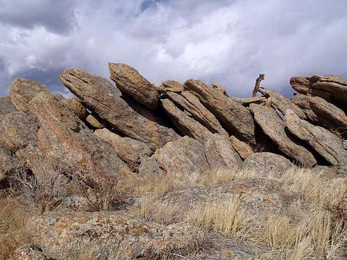
Stacked summit slabs
This is a scenic jaunt to a classic Colorado Springs summit. The route mixes social trails, heavily-worn motorized trails and a faint cairned footpath to gain the rocky, open summit of Tenney Crags. Take your eyes off the obvious signs of overuse in the area and enjoy the scenery along this trek. Strangely enough, the one thing this route lacks from start to finish is a view of Pikes Peak, though the dip into Bear Creek Canyon and the views of neighboring peaks including Cheyenne Mountain, Mount Rosa, Mount Arthur, Cameron’s Cone and the Vigil Group more than make up for this.
Approximate Roundtrip Distance: 7 miles
Net Elevation Gain: 2800 feet
YDS Class: 2
Getting There

Mount Rosa above rocky outcrop

Arthur and Cameron
• From I-25 in Colorado Springs, take US Highway 24 (Cimarron Street) west to 21st Street.
• Head south on 21st Street, which turns into Cresta Road, for roughly 3 miles.
• Turn right on Cheyenne Boulevard.
• At the fork, follow the road to the right onto North Cheyenne Canyon Road.
• Follow North Cheyenne Canyon Road west as it ascends the canyon toward Helen Hunt falls.
• Continue past Helen Hunt falls up the switchbacks to the end of the pavement.
• Park in the large gravel parking area on your left.
 Rocky Benchmark |  Rocky Summit Area |  Summit Jars |
Route Description


Cameron, Evans Group, Thunder Butte

East from the summit boulders

Cameron, Evans Group, Thunder Butte
From the large gravel parking lot, pick up the social trail up the gully heading north. This social trail begins not far past the barricade / gate at the western edge of the parking lot.
• Head steeply north up the drainage on this rustic trail for approximately one half mile.
• The social trail will intersect near the top of a ridge with Trail #667 (Jones Park Trail).
• Follow #667 for about one mile along a ridge, then dropping into Bear Canyon.
• Cross Bear Creek and head west on #667 toward Jones Park.
• Less than ½ after crossing Bear Creek, (38.79438N, 104.92886W, per SP member csmcgranahan) https://www.summitpost.org/users/csmcgranahan/19520 keep your eyes peeled for a social trail jutting off to your right up-hill.
VERY useful photo https://www.summitpost.org/critical-junction-to-tenney-crags/188613/c-188601
Above the bridge and junction with Captain Jack's Trail one encounters a spot where a small stream crosses the path between rocks. Between 50-100 paces past this a faint trail branches off to the right at greater than 90 degrees.
Last time by it we put a cairn at the base of a tree just past the trail. The cairn may disappear, but the little water crossing was there last Aug even before the big rains and is a nice clue to be looking for the path. Via jksova@q.com
This social trail, while faint at times, is very well cairned and will carry you for roughly a mile to the summit of Tenney Crags
• Carefully follow the cairns as the route ascends the drainage.
• After roughly three-quarters of a mile of travel on the cairned path, the route departs the drainage and turns east through a rocky, treed area west of and below the summit.
At times the path becomes braided with multiple cairn routes. At this point a GPS is extremely useful if you wish to gain the summit in an expedient fashion.
• The route climbs increasingly rocky terrain before curving southward to approach the final summit boulders from the north.
• Take in the expansive views all around you from the open, rocky summit!
Essential Gear

The Springs

Mount Rosa
In addition to standard gear and outerwear appropriate for the season, make sure you have a good map and compass for navigation. A GPS is extremely useful for pinpointing the high point when the cairn paths start getting crazy just below and west of the summit.
 Garden of the Gods |  Descending cairned path |  The Almagres |
cshanek - Oct 4, 2020 5:52 pm - Hasn't voted
Trail 667 Has Been MovedThe description posted for this route is no longer correct. Trail 667 was moved away from the Bear Creek Drainage (trees are cut down intentionally all across the old trail) so it is a little more committing to reach the northerly turn (picture of tree in middle of trail). The approach I took was to follow the new trail until Mt Kineo was to my South, drop down 150 feet or so through the woods, find a place to cross the creek, and try to find the old turn off. This turnoff is about 4.5 miles now from the main parking lot.