
|
|
Route |
|---|---|
|
|
40.52300°N / 118.171°W |
|
|
Hiking |
|
|
Fall |
|
|
Most of a day |
|
|
Overview
All of the trip reports posted at www.cohp.org are based on approaches fromthe west. However, here at SP, several of those listed in the summit log for Star Peak had mentioned they had accessed the peak from the east or the south. With the El Dorado canyon road washed out last year, I began to research a way in from the east and thanks to Paul Burkholder who responded to my emails about his experience with the east side and Spence, I decided I wanted to try it from the east via the Star Creek Canyon route. Spence had posted a great album of his trip to the Humboldt mountain range which included Star Peak and a couple of his photos gave me the key to a route I wanted to try from the Star City area. Star City was established very quickly but didn't last very long. The ore found in the area was very rich and sparked a flurry of activity that had over 1000 people moving in. Star City went from being the largest town in the Humboldt area in 1863 to being all but deserted by 1870. There were several mines in the area, some of which can still be visited although I had no time to do so. My hike took me right past the Queen of Sheba and DeSoto mines. Spence has a nice pic of the Queen of Sheba mine in his Humboldt album.
After studying up on the area, I regretted only having a day to spend in the area but the fact that I was there on opening day of Chukar hunting season, was reason enough to keep my visit short this time. This area is rich in history and a traverse of all the Humboldt range peaks would be a special experience.
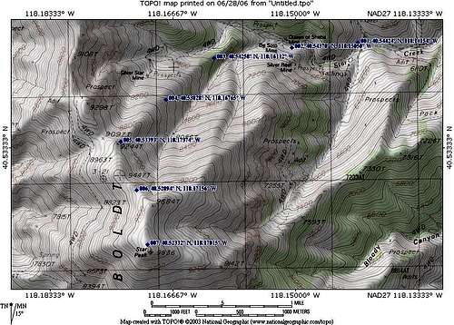
NOTE - Many of the topozone links now do not function properly so I will edit this page and re-construct it in the near future (date July 2015)
Getting There
The trailhead for this hike is a bit over 40 miles from Winnemucca and 55 miles from Lovelock Nevada. I-80 is the highway that covers most of the way from either town and to find the trailhead (parking area), follow below:From Winnemucca or Lovelock, take I-80 to the exit for NV 400 and head south. This is close to Mill City and a big TA truck stop. NV 400 is a paved road and in great condition. At the 8.7 mile mark, watch for a road (and a sign about Star City) on the west side of the road.
Take this dirt road 4.8 miles to a place where you can park near the old Star City site. The road is fairly rough but manageable to the mouth of the canyon in a passenger vehicle. Once the road starts up into the canyon, you may wish to park and hike as the last mile and a half or so is a rough and narrow road if you have a low clearance vehicle, you will need to park it at about the 3.3 mile mark and walk up the canyon. This will add three miles to the overall hike and another 800 feet or so of elevation gain. Still, this would keep the hike to around ten miles and close to 5000 feet of elevation gain should you decide to park short of the Star City ruins parking area.
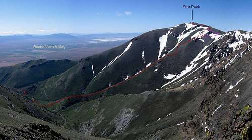
The route up the ridge
Route Description
6.5 Miles round trip4000 feet elevation gain based on parking at the Star City ruins area.
My GPS showed that it was only 2.3 miles as the crow flies to the summit of
Star Peak from where I parked at a spot near the Star City ruins. However, I wasn't going to be able to fly like a crow so I knew I had my work cut out for me.
Head up the old Jeep road and go past the Queen of Sheba mine looking for the ridge that leads up from THIS spot. It is a bit over a mile of road walking to this point and as you go up the road, the road deteriorates to where it is basically a washed out road bed. I just headed up through the brush to access the ridge. Once on the ridge, I just worked my way up, always looking for the most straightforward way. As you go up the ridge, you can look over to a road that leads up to the Silver Star Mine. Continue following the rounded spine of the ridge and aim for the saddle at 9097 feet. I made waypoints as I went up and I was also careful to note where I topped out on the saddle at 9097.
As you top out on the saddle, now just aim south towards the summit of Star Peak, basically just easy cross country through shallow brush. To your left you will notice the BLM antenna set up which was put in by helicopter a couple of years back. Paul Burkholder mentioned that it was probably put in sometime in 2004. This picture taken by Dennis Poulin pretty much shows the rest of the route from the 9097 saddle.
There is nothing difficult about this route and after being on the mountain, I could see that you could also use the ridge that leads up to the BLM Antenna structure or even further east as Paul Burkholder went.
I liked this approach because it was one where I didn't see even another bootprint until reaching the saddle.
I noted that a similar route to the top was followed by Gerry Pennington which he posted about on peakbagger.com
Check out this panoramic pic by Spence thanks to a shot that he took from Van Zandt peak. Spence takes some of the best panoramic shots I've seen.
Essential Gear
Long pants (not shorts) due to the brush and I'd avoid this route in the spring (ticks). Fall would be an ideal time although thunderstorms would keep me off of this exposed route while I waited for good weather. Carry water and sun protection. This would be a very hot hike in the summer and so I feel fall is the best. Paul Burkholder would most likely carry skiis up this ridge in the wintertime and ski down it. See his pic HERE.Dead batteries and no register
My camera batteries died on the way up and if anyone uses this route, I'd appreciate it if you could add some of your pics to supplement this route page.I was asked by a friend why I didn't sign the register when I was there and I mentioned to him that the summit was covered in snow and I couldn't find it. Besides it was cold, windy and I had my wife waiting down at the truck and I had to get down before it got dark so I really didn't spend much time on the summit. My camera batteries were dead and my wife had contacted me by our walkie talkies to mention that a hunter had visited her to warn her about a large cougar that had been seen on the mountain and wanted to know if I'd seen any tracks. Yikes. I headed down quickly.
After reading Bob Burd's trip report on his visit, I didn't feel so bad about not finding the register since he didn't see it either. Neither one of us knew it was in a white PVC pipe type container and white has a tendency to be hard to see if covered with snow. Bob did uncover the benchmark in his efforts to find the register.
"At the summit I found a small rock wind screen mostly filled with snow. I dugout the benchmark in the center of this, but found no sign of the register. Ireally didn't feel like digging the place up while trying to keep the wind fromfreezing my face. Though my stay was rather short, the views were superb andI took the time to take several photographs along the spine of the range and off either side into the Nevada desert. "