
|
|
Mountain/Rock |
|---|---|
|
|
43.54717°N / 111.35092°W |
|
|
Bonneville County |
|
|
Hiking, Mountaineering |
|
|
Spring, Summer, Fall |
|
|
8620 ft / 2627 m |
|
|
Overview
Stouts mountain sits on the southern part if the Big Hole Mountains. Prominence is about 1300ft. Stouts mountain offers very beautiful views of the surrounding areas.You have the Swan Valley area to the south that you can see for miles, the Tetons to the east, other Big Hole Mountains to the North, and some Snake River Range to the southern area as well. The hike is not long and offers a fun day hike.
At the top, you can pay respects to Al Courchaine. His ashes and a marker were placed on the summit in 2011
Getting There
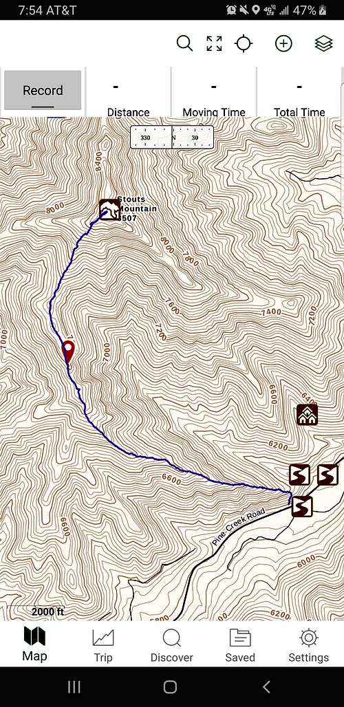
You can access Stouts mountains from HWY 31 coming out of the Swan Valley area on Pine Creek Pass. There are two places you can stop to access the beginning of the hike. On the northwest side of the highway is a pulloff that will accomidate up to 2 standard sized vehicles. A gate can be seen but has overgrowth but unofficially You cmarks as a beginning point of the trail. You can then start hiking up an old ATV trail upward to the ridge.
When my small group did it, we simply parked at the Pine Basin Lodge. We simply did not know of the pulloff and gate access until after we did the hike. We simply went up the side of the ridge (which was steep) until we stumbled upon the trail. The Lodge is very close to the pulloff so either spot will work for this hike.
Route
After beginning up the ridge, you will come across a trail. It is hard to miss since its right in the middle of where you are heading. The trail is nice since the ridge is rather steep. It offers a cleared approach to the top of the ridge.Once on the ridge, the trail eventually goes away but at that point you are in the clearing. You have a clear view through the brush of the peak so your target is an obvious marker as to where you need to head without the trail.
Along your way you will encounter 3 high points before hitting the peak. Despite what it might look like, it makes it an easier journey to actually hike up to the top of each high point. You then simply head up the last stretch towards the summit.
A bottle has been left on the top of the summit to have a place where you can sign the summit register.
Summit Distance = 2.7 miles (One Way)
Red Tape
No redtape known. Hike freely just be sure to check in on any fire bans throughout the season if you plan on backpacking or camping anywhere in this area.
When to Climb
Later spring would be the ideal time to start since snow would most liely still be on the summit. And you could go as late as November. Just depends on when winter in Idaho feels like beginning.
Camping
Many camping sites can be found throughout this entire range. You can go to designated ones easily found online or choose one for yourself. As for backpacking to this summit, we saw evidences of people having done that but I wouldnt recommend it. The terrain does not offer the best kind of backpacking weather for this specific summit.
External Links
Got some information from this link:
https://www.idahoaclimbingguide.com/bookupdates/stouts-mountain/