
-
 58520 Hits
-
 92.26% Score
-
 38 Votes
|
|
Area/Range |
|---|---|
|
|
46.74500°N / 121.7°W |
|
|
Hiking, Mountaineering, Trad Climbing, Scrambling, Skiing |
|
|
Spring, Summer, Fall, Winter |
|
|
6971 ft / 2125 m |
|
|
Overview
The Tatoosh Range is located along the southern boundary of Mt. Rainier National Park in Washington State. A smaller range of peaks, the Tatoosh runs roughly east-west, beginning with Tatoosh Peak (located just outside the National Park in the Tatoosh Wilderness Area) to the southeast and ending with Eagle Peak to the west. There are at least 13 prominent named peaks in the range with summit elevations generally between 6000-7000 feet in height with the highest being well-named Unicorn Peak at 6971 feet. The Tatoosh Range is an awesome place to go for late winter and spring snow climbs and ski descents due to good access via the Nisqually entrance into the national park. Actually, the majority of these peaks are best done March through June when the hideous talus that is found throughout the range is covered in snow.
The Tatoosh peaks are a nice mix with something to offer to everyone. The peaks range from easy walk ups like Plummer, to fun class 3-4 scrambling like what's found on Pinnacle and Eagle peaks. There are even some low class 5 rock climbs. Many of the peaks can be combined for a larger outing. Two popular combinations are Eagle-Chutla and Castle-Pinnacle-Plummer. If you're looking for an all-day or multi-day peak-bagging adventure, try the classic Tatoosh Traverse. All of the peaks in the Tatoosh Range command spectacular views of Mt. Rainier across the valley to the north, as well as views to the south of the Goat Rocks Wilderness, Mt. Adams, Mt. Hood, and Mt. St. Helens. See the table below for a list of the major Tatoosh Peaks.
| Name | Photo | Elevation | Prominence | Standard Route |
| Unicorn Peak |
 |
6,971 | 2,120 | Snow Lakes Trail to South Face - Low 5th Class |
| Boundary Peak |
 |
6,780 | 100 | Snow Lakes Trail to South Face - Class 3 |
| Pinnacle Peak |
 |
6,562 | 582 | Pinnacle Saddle Trail to South Face - Class 3 |
| Foss Peak |
 |
6,524 | 424 | Snow Lakes Trail to South Ridge - Class 2 |
| Stevens Peak |
 |
6,510 | 800 | Snow Lakes Trail to Maple Creek to West Ridge - Class 3 |
| The Castle |
 |
6,460 | 240 | Pinnacle Saddle Trail to SE Face - Class 4 |
| Plummer Peak |
 |
6,370 | 430 | Pinnacle Saddle Trail to North Ridge - Class 1 |
| Tatoosh Peak |
 |
6,310 | 970 | Tatoosh Trail - Class 1 |
| Wahpenayo Peak |
 |
6,231 | 811 | Eagle Peak Trail to West Ridge - Class 3 |
| Lane Peak |
 |
6,012 | 560 | Southeast Slopes - Class 3 |
| Denman Peak |
 |
6,006 | 200 | Pinnacle Saddle Trail to East Ridge - Class 1 |
| Chutla Peak |
 |
6,000 | 440 | Eagle Peak Trail to West Ridge - Class 2+ |
| Eagle Peak |
 |
5,958 | 240 | Eagle Peak Trail to South Ridge - Class 3 |
Getting There - MRNP Nisqually Entrance
From Portland:
From I-5 north to exit 68 and turn right off the exit and follow Hwy 12 for about 31 miles east to Morton. Then turn left/north on Highway 7 and follow it for 16 miles to the small town of Elbe. Turn right/east on Highway 706 and follow it 11 miles to the southwest (Nisqually) entrance to Mt. Rainier National Park.
From Seattle:
To reach the southwest entrance, take Highway 7 from Tacoma 35 miles south to Elbe and head east on Hwy 706 another 11 miles to the Nisqually entrance.
Once inside the park, there are three primary maintained trailheads that provide access to nearly all of the Tatoosh Peaks. They are described in the table below:
| Eagle Peak Trailhead | From Longmire inside the park, follow the main road past the Wilderness Information Center and continue through the park employee housing area to a bridge across the Nisqually River. The signed trailhead is another fifty feet past the bridge on the left. (Alternately you can park by the Wilderness Info Center and walk in). The trail climbs 3.5 miles to the saddle between Eagle and Chulta Peaks. This is the best approach to the western end of the range. |
| Pinnacle Saddle Trailhead | Continue past Longmire up towards Paradise and turn right onto the Stevens Canyon Road (signed for Ohanapecosh). Do not continue all the way to Paradise. Continue on the Stevens Canyon Road for several miles and reach a parking area at Reflection Lakes on the north side of the road. The signed trailhead is just across the road to the south. This is the easiest approach into the center of the Tatoosh range. The trail climbs 1.3 miles to the saddle between Pinnacle and Plummer Peaks. |
| Snow Lake Trailhead | Continue east past the Reflection Lakes for another 1.5 miles to reach a signed pullout on the right (south) side of the road. The Snow Lakes Trail heads southeast across "The Bench" and reaches Snow Lake after 1.2 miles. This is the common approach for the Unicorn Peak area. |
Note the Stevens Canyon Road typically is closed from late October through Memorial Day weekend. If this is the case, park at the Narada Falls parking lot and hike east a couple hundred feet up a short, steep hill to reach the road and follow the road as it makes a sharp turn to the east and reaches the trailhead.
Tatoosh Wilderness Area
The easiest way to reach Tatoosh Peak which is located outside the National Park in the adjoining Tatoosh Wilderness Area is from Packwood. This small town is located on the west side of White Pass along the Cowlitz River and Highway 12. From the center of town, head northeast on Road 52 (Skate Creek Road). Cross the Cowlitz River on a bridge, make one big leftward switchback and turn right onto FS 5270. Follow this gravel road to its end at the trailhead. The trail climbs for 2 miles to the south ridge of Tatoosh Peak, passing a side trail heading left to Tatoosh Lakes.
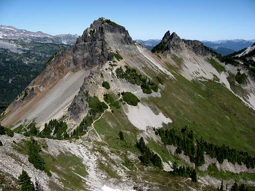
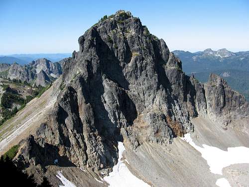 Pinnacle From The Castle Pinnacle From The Castle |
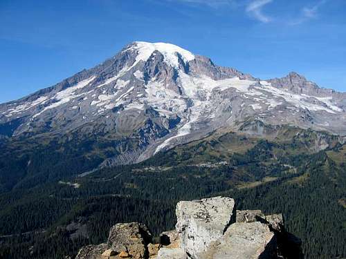 Rainier from the summit of Pinnacle Rainier from the summit of Pinnacle |
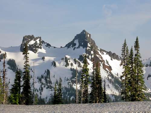 Castle and Pinnacle in spring Castle and Pinnacle in spring |
Camping/Red Tape
Camping in Mt. Rainier National Park is regulated by the National Park Service. The closest car campgrounds to the Tatoosh are Sunshine Point (just inside the Nisqually entrance) and Cougar Rock (located between Longmire and Paradise). Campgrounds are large, however they are also very popular and often fill up with tourists on summer weekends. It is possible to make reservations for some campsites in advance.
Backcountry camping is also permitted in the Tatoosh range, requiring a free backcountry permit (available at the Wilderness Information Center in Longmire). There are a number of possible areas to camp throughout the range although the National Park Service restricts both the number and size of groups in the backcountry. There are also established trail-side campsites at Paradise River (Wonderland Trail - north of the Tatoosh) and at Snow Lake.
Backcountry camping is also permitted in the Tatoosh range, requiring a free backcountry permit (available at the Wilderness Information Center in Longmire). There are a number of possible areas to camp throughout the range although the National Park Service restricts both the number and size of groups in the backcountry. There are also established trail-side campsites at Paradise River (Wonderland Trail - north of the Tatoosh) and at Snow Lake.
A $15 fee is required to enter Mt. Rainier National Park. There are no additional fees for hiking or climbing in the Tatoosh Range. A Northwest Forest Pass may be required to park at the trailhead for the Tatoosh Wilderness Area, or you can park a quarter mile away to avoid the fee.
Fee Information - Mt. Rainier NP
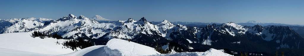 Tatoosh Range Panorama from the Nisqually Glacier
When to Climb
Many of the Tatoosh peaks are climbed all year round. While access may be an issue in the winter months as the road is generally not plowed past Paradise, a number of the peaks are often visited in the winter by climbers, backcountry skiers and snowboarders. Caution should be taken around the cliffs and steep slopes in the winter as there is likely some avalanche danger in the Tatoosh.Unicorn Peak is probably best done in the early season as climbing on snow is much nicer than slogging up the steep scree slopes in the summer. Many of the other peaks are probably best in the late-spring/summer/fall. Bring your insect repellent in the early season.
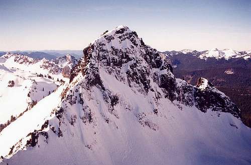 Winter on Pinnacle Peak Winter on Pinnacle Peak |
 Spring on Lane Peak Spring on Lane Peak |
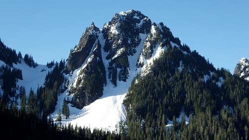
 Summer on Castle and Pinnacle Summer on Castle and Pinnacle |
Area Webcam
See this page for good webcams of the Mount Rainier area! Tatoosh Webcam