
-
 2835 Hits
-
 77.48% Score
-
 8 Votes
|
|
Route |
|---|---|
|
|
Scrambling, Via Ferrata |
|
|
Summer, Fall |
|
|
Most of a day |
|
|
I |
|
|
Overview
The north face of Thaneller is steep, threatening and impressive. It looks like no go terrain for the normal hiker. That is, however, wrong.


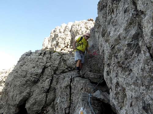
The most interesting and entertaining ascent to Thaneller summit uses this rock face. There is a via ferrata like route, called Werner Riezler Steig, intelligently using ledges, chutes and secured rock steps to overcome this wall of rocks in some traverses, zigzags and easy climbing moves. The route is partly secured with steel ropes and some iron pegs. It is, however, not a fully secured via ferrata and some climbing parts are – thankfully - free of ropes. All secured parts were renewed in 2016.
Werner Riezler Steig is a summer and autumn route – well, more of a summer route as the north side of Thaneller does not receive much sun. Many years ago I did that route two times in late spring/early summer with some snow resting in the wall and on the route. That is o.k. if you can master those conditions! In autumn you might encounter iced rock parts. So best season is summer!
Getting There

Trailhead for Werner Riezler Steig is Heiterwang, Karlift.
Heiterwang is a railroad station. It is a 2 km foot walk from the railroad station to the trailhead.
The hiker parking area is at Karlift ski lift valley station northwest of Heitwerwang.
Road number 179 leads from Reutte or from Erwald / Lermoos and Fernpass to Heiterwang. Leave road number 179 at the exit “Karlift / Heiterwang” northwest of the village of Heiterwang and follow the signs “Karlift” shortly to the parking area above the road. 2019: no parking fee.
Route Description
From the parking area follow the closed road shortly to a switchback. Leave the road to the right and ascend the meadow until a trail is visible. Follow the trail up the ski run first to the right then straight into Kärlesbach valley; crossing some more forest roads. There are some old signs for “Thaneller”.
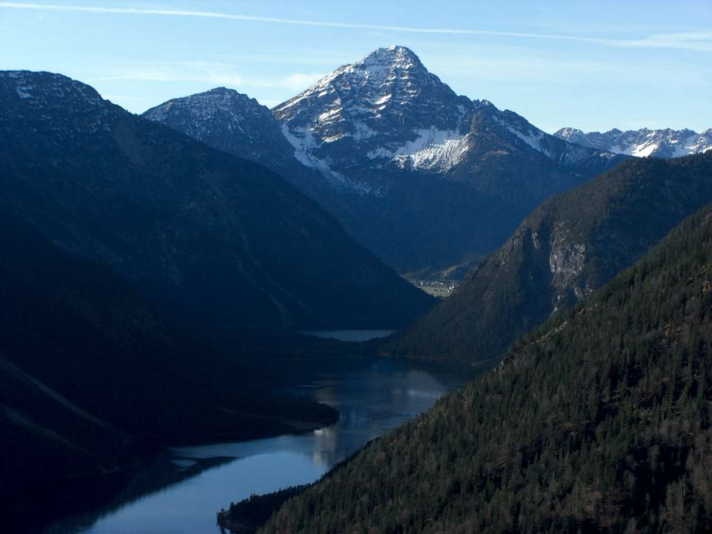
Near Kärlesbach you reach another forest road. Follow this road deeper into Kärlesbach valley; the Thaneller rock face and the huge cirque below is now visible.


After crossing Kärlesbach leave the road at a sign “Thaneller, Werner Riezler Steig” to the left and follow the trail steeply up into broad Thanellerkar. At a huge block there is a trail junction. To the left there is the “Bergwachtsteig” traversing the whole Thaneller cirque to its eastern limitation and then dropping down to Heiterwang. To the right a trail goes to the western limitation of the cirque and descends to Rintlalm.


The route to Thaneller goes straight on and zigzags up the cirque until it reaches the base of the north face.
A short secured rock climb leads up to a broad ledge system. The route traverses the lower north face on these ledges to the east; there are some short climbs involved. The route then starts to ascend in the direction of the north ridge of Thaneller. Ledges, chutes and rock climbs are leading up to the ridge with breathtaking views down to Plansee, the huge dammed lake near Heiterwang and Reutte.


The route now follows the north ridge up to the already visible summit, some rock climbs, grade I, involved.
Pay attention to co-hikers; Thaneller consists of the dolomitic Hauptdolomit a rather frail and crumbly rock. Amounts of loose scree litter the whole route with the exeption of the climbing parts; these rocks thankfully are firm and good to climb.

Traverse option:
Descend the south ridge in the direction of Berwang. Above the village take forest roads which traverse to the east and ascend to Almkopf cableway summit station (about 250 m of ascent!). Take there the trail back to Heiterwang, navigating first around Achseljoch, the eastern sidekick of Thaneller, on its east and north side then descending into Wannenbach valley. From the valley bottom there is a 2 km footwalk back to the trailhead. Good traverse - very long day!


Essential Gear
Hiking gear, good shoes and a helmet.
Beginners may use via ferrata self belay for the secured parts. But not all climbing parts are secured!
