


-
 3142 Hits
-
 85.87% Score
-
 21 Votes
|
|
Route |
|---|---|
|
|
45.63170°N / 7.53948°E |
|
|
Hiking, Mountaineering |
|
|
Spring, Summer, Fall, Winter |
|
|
Note
|
La montagna chiama i suoi figli, ed essi rispondono fedelmente al suo appello… Osvaldo Cardellina, Diario alpinistico, 1964-65 Page texts: @ OsvaldoCardellina "Osva", passed away on May 2, 2022. Page owners: Christian Cardellina e Osvaldo Cardellina. Any updates from September 12, 2022: Antonio Giani, page administrator, friend and climbing companion. Testi della pagina: @ OsvaldoCardellina "Osva", scomparso il 2 maggio 2022. Proprietari pagina: Christian Cardellina e Osvaldo Cardellina. Eventuali aggiornamenti dal 12 settembre 2022: Antonio Giani, amministratore della pagina, amico e compagno di salite. |
Frozen Overview

There are many ways into Mont Glacier. But everyone goes upwards to the South-southwest Slope or Normal Route. And they are right: it is quiet and does not create any problem. I met with Emilio even the "Honourable Member" Violante, of course escorted. He pretended, as he went down, not to notice us. And we of him. This is our home, not the Italian Parliament. Here we are completely masters and there are no laws, articles and paragraphs. In fact there exists a law: that of the strongest. Against the weather. When Emilio and Gianfranco we got from Etsely, bypassing the Hill Fussì, the task was difficult. It was not the usual Mont Glacier, what the other side the tourists are also rising. This was for "Hard Men" and even the camera Emilius not had survived the cold jamming. Nevertheless, three photos were successful, but I find it just now. Fourteen years later. Under the blanket of fresh snow had stopped Gianfranco on big shoulder, not far from the Summit. Emilio had arrived. With hard work, but had arrived. Winter does not always manifest in Winter, but sometimes also in the month of the end of October; for him there is no human calendar, and Mont Glacier knows it. But he did not look at anyone, me even with whom he owes a great debt. When in one of the many climbs I retrieved the book Peak (it's still in my house and if anyone I wants to see a consult is enough) that I was going to be destroyed "immortalized his Life". I think it was 1975, but I'm not sure and I have to check. This records the "Life", at least for the Mountaineering since 1920 or so. For the rest we have to lean to the Ancient Authors, of all Mario Aldrovandi and the '800 to the famous Abbot Pierre Chanoux, the first climber from Champorcher starting in 1848, where he was born April 3th, 1828, and which held the "profession" of the Curate. A journey, even if only in the mountains, away from nearly two centuries that we try to deal with our limited resources and a bit of Fantasy. Incidentally here are not Cervino, in Switzerland called Matterhorn, where you can almost count the stones and the steps of those who have passed.
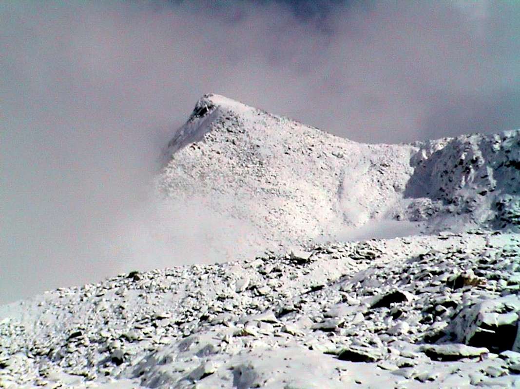
![]()
October on Mount Glacier from Clavalité Vallon, through Fussì Pass
The Mont Glacier is like the God Janus: it has a double face. When you in the summer, took note of his name, go to Glacier thinking of a nice fresh ice cream, a refreshing drink or something else similar, you are "big rip-off" up from the beginning. He will loading down on to you all the heat from its ancient rocks crumbling and burned by the sun causing you an irrepressible thirst. As in the Desert. In addition, it is also double in his appearance: in the South is "stretched" quiet in his "fauteuil", giving the impression of being mild and almost resigned to fate to see go up all these "Rabadan"(people of all kinds, in the local dialect generally understood as a tourist metropolitan) on her belly, to the North by steep falls instead crashing on the rocks below as a whole one. As a large Royal Eagle, "perched" between earth and sky, spreads its wings capable of yielding a large booths between good and poor (Mountaineers). Almost want to "graze" the first and to attract the latter. But do not take it every now and then by a small stone walls Northern throws him down, pretending to throw himself on the stony ground. Better to stay on the edge between the two: it is safe, despite the look with a view from below, it is not difficult. So even thought the three of 1915. The other two its ridges oriented in the southwest and east, respectively, which are separated from Vallons Clavalité-Savoney and Champdepraz-Lakes, are easy and secure. But I'll give some advice for the first is better to have the rope because now immediately after the Col Fussì has a very steep wall exposed in the Southeast that, when wet, it becomes tricky (to me has already happened to go back because the rope is not no companion wanted to do this); the second is formed by rock not good and requires the ability to know how to choose the path, especially downhill. The other sides facing West, South, Southeast and East are not to be taken into account, because often covered with layers of grass or because they have complex paths and dangerous. Things of the past that "our fearless Explorers" have already made at the end of '800 and for some routes there are no names, that we find for the first winter ascent: in January 1924 by the brave Mario Aldrovandi, a lover of these neglected mountains on which he left valuable informations, acompanied from the expert Mountain Guide Champorcher Gamekeeper Vassoney. Then, after the rising on the North-northeast Edge by Carlo Assale, Giuseppe "Pinot" Quaglia and Eugenio Saragat Glacier falls into the oblivion and "does not give any sign of life". It was until the mid-Seventies when a number of young local climbers (Roberto Nicco, Pietro Bosonetto, Elio Vittaz, Paolo Zappa, Andrea, Claudio and Silvio Bastrentaz) go in search of something new on this mountain of home. And we must not forget even the famous at the epoch Felice Mondini and Nicola Vigna, which together with the "noble" Giulio Toesca by Castellazzo, October 6th, 1895 to be exploring the complicated South Side leaving us a very less clear and understandable report, including up and down for the same with variations, we can not decipher well today; because the study of mountains is also done by these "fancy climbing", which require high Spirit of Sacrifice and unusual Will.
Finally, to conclude, a peek through there I gave myself. Over a ...
![]()
Northeast Wall above Gran Lago and Leità Lochs in Champdepraz Vallon
Finally, to conclude, a peek through there I gave myself. Over a ...

Molte son le vie che portano al Mont Glacier. Ma tutti vanno sù per il Versante Sud-sudovest o Via Normale. Ed han proprio ragione: é tranquillo e non crea nessun problema. Con Emilio ho incontrato anche l'Onerevole Violante, logicamente scortato. Lui ha fatto finta, mentre scendeva, di non accorgersi di noi. E noi di lui. Questa é casa nostra e non il Parlamento Italiano. Qui siamo completamente padroni e non esiston leggi, articoli e commi. Anzi una Legge c'é: quella del più forte. Contro le intemperie. Quando con Emilio e Gianfranco siam saliti dall'Etsely, scavalcando il Col Fussì, l'impresa era ardua. Non era il solito Mont Glacier, quello che dal versante opposto salgon anche i Turisti. Questo era per "Uomini Duri" e neppur la macchina fotografica di emilius aveva resistito al freddo inceppandosi. Ciononostante tre foto eran riuscite, ma lo scopro sol ora. Quattordici anni dopo. Sotto la coltre di neve fresca che aveva fermato il Gianfranco allo Spallone, non molto lontano dalla Sommità. Emilio era arrivato. Con fatica, ma era arrivato. Non sempre l'Inverno si manifesta d'Inverno, ma a volte anche nel mese di fine Ottobre; per Lui non esiste il calendario umano, ed il Mont Glacier lo sà. Ma lui non guarda in faccia nessuno, neppure me con il quale lui ha un grande debito. Quando in una delle varie ascensioni ho recuperato il libro di Vetta (é ancora a casa mia e se qualcuno lo vuole consultare é sufficiente chiedere) che stava per andare distrutto ho "eternato la sua Vita. Mi par che fosse il 1975, ma non son sicuro e debbo controllare. Questo registra la "sua Vita", almeno quella Alpinistica dal 1920 circa. Per il resto dobbiam appoggiarci agli Antichi Autori, tra tutti Mario Aldrovandi e per l'800 al famoso Abate Pierre Chanoux, primo salitore nel 1848 partendo da Champorcher, dov'era nato il 3 Aprile 1828, e nel quale svolgeva la "professione" di Curato. Un viaggio, anche se solo di montagna, lontano di quasi due secoli che noi proviamo ad affrontare con le nostre limitate risorse ed un pò di Fantasia. Daltronde qui non siam sul Cervino, dove si possono quasi contare i sassi ed i passi di coloro che sono transitati.
Il Mont Glacier é come il Dio Giano Bifronte: possiede doppia faccia. Quando voi di estate, preso atto del suo nome, andate al Glacier pensando ad un bel gelato fresco, ad una bibita rinfrescante o a qualcosa di altro similare, siete già "fregati" fino dalla partenza. Lui vi coprirà con una giornata torrida facendo uscire fuori tutto il calore dalle sue rocce millenarie bruciate e sgretolate dal sole provocandovi una arsura incontenibile. Come nel Deserto. Inoltre é double anche nell'aspetto: a Mezzogiorno si "distende" tranquillo nel suo "fauteuil", dando l'impressione d'esser mite e quasi rassegnato alla sorte di vedere salire tutti questi "rabadan" (persone d'ogni tipo, nel dialetto locale generalmente inteso come turista metropolitano) sulla sua pancia; a Nord precipita invece con ripide pareti che si schiantano sulle sottostanti pietraie come in un tutt'uno. A guisa di grande Aquila Regale, "appollaiato" tra tera e cielo, distende le sue ali atto a formare un gran separé tra buoni e scarsi (Alpinisti). Quasi a voler "pascolare" sti ultimi ed ad attirar i primi. Ma non fidatevi perché ogni tanto dalle sue pareti Settentrionali un sassolino lo scaglia giù, facendo finta di lanciar lo stesso sulla pietraia. Meglio restar sullo spigolo tra le due: é sicuro e, nonostante l'aspetto con vista da sotto, non é difficile. Così pensavano anche i tre del 1915. Le altre due sue creste orientate a Sudovest ed ad Est, rispettivamente separanti dai Valloni di Clavalité-Savoney e di Champdepraz-Laghi, son facili e sicure. Però un consiglio lo voglio dare: per la prima é meglio aver la corda perché subito dopo il Col Fussì presenta un tratto molto ripido ed esposto a Sudest che, se bagnato, diventa delicato (m'é già successo di tornare indietro perché il compagno senza corda non voleva procedere); la seconda é formata da roccia non buona e richiede la capacità di saper scegliere il percorso, soprattutto in discesa. Gli altri versanti rivolti ad Ovest, Sud, Sudest ed Est non sono da prender in considerazione, perché spesso ricoperti da strati erbosi o perché presentano percorsi complicati e pericolosi. Cose d'altri tempi che i "nostri valorosi Esploratori" han già fatto a fine '800 e per alcuni percorsi non esistono nomi, che invece troviamo per la prima salita invernale: nel Gennaio del 1924 da parte del bravo Mario Aldrovandi, amante di queste neglette montagne sulle quali ha lasciato preziose informazioni, accompagnato dalla esperta Guida di Champorcher Guardiacaccia Vassoney. Poi, dopo la salita sullo Spigolo Nord-nordest da parte di Carlo Assale, Giuseppe "Pinot" Quaglia ed Eugenio Saragat, il Glacier cade nel dimenticatoio e "non dà più segni di vita". Bisogna attendere la metà degli anni Settanta quando una serie di giovani Alpinisti locali (Roberto Nicco, Pietro Bosonetto, Elio Vittaz, Paolo Zappa, Andrea, Claudio e Silvio Bastrentaz) vanno alla ricerca di qualche cosa di nuovo su questa montagna di casa loro. E non dobbiamo dimenticare neppure i famosi per l'epoca Felice Mondini e Nicola Vigna che, insieme al "nobile" Giulio Toesca di Castellazzo, il 6 Ottobre 1895 vanno ad esplorare il complicato Versante Meridionale lasciandoci una relazione che, tra salita e discesa per lo stesso con varianti, non riusciamo a decifrare bene ancor oggi; perché lo studio delle montagne é fatto anche da parte di queste "stravaganti ascensioni", tali da richiedere alto Spirito di Sacrificio ed inusuale Volontà.
Infine, per concludere, una sbirciatina per di là l'ho data pur io. Più d'una ...
![]()
Northwest Face above Medzove Pass in Savoney Vallon
Il Mont Glacier é come il Dio Giano Bifronte: possiede doppia faccia. Quando voi di estate, preso atto del suo nome, andate al Glacier pensando ad un bel gelato fresco, ad una bibita rinfrescante o a qualcosa di altro similare, siete già "fregati" fino dalla partenza. Lui vi coprirà con una giornata torrida facendo uscire fuori tutto il calore dalle sue rocce millenarie bruciate e sgretolate dal sole provocandovi una arsura incontenibile. Come nel Deserto. Inoltre é double anche nell'aspetto: a Mezzogiorno si "distende" tranquillo nel suo "fauteuil", dando l'impressione d'esser mite e quasi rassegnato alla sorte di vedere salire tutti questi "rabadan" (persone d'ogni tipo, nel dialetto locale generalmente inteso come turista metropolitano) sulla sua pancia; a Nord precipita invece con ripide pareti che si schiantano sulle sottostanti pietraie come in un tutt'uno. A guisa di grande Aquila Regale, "appollaiato" tra tera e cielo, distende le sue ali atto a formare un gran separé tra buoni e scarsi (Alpinisti). Quasi a voler "pascolare" sti ultimi ed ad attirar i primi. Ma non fidatevi perché ogni tanto dalle sue pareti Settentrionali un sassolino lo scaglia giù, facendo finta di lanciar lo stesso sulla pietraia. Meglio restar sullo spigolo tra le due: é sicuro e, nonostante l'aspetto con vista da sotto, non é difficile. Così pensavano anche i tre del 1915. Le altre due sue creste orientate a Sudovest ed ad Est, rispettivamente separanti dai Valloni di Clavalité-Savoney e di Champdepraz-Laghi, son facili e sicure. Però un consiglio lo voglio dare: per la prima é meglio aver la corda perché subito dopo il Col Fussì presenta un tratto molto ripido ed esposto a Sudest che, se bagnato, diventa delicato (m'é già successo di tornare indietro perché il compagno senza corda non voleva procedere); la seconda é formata da roccia non buona e richiede la capacità di saper scegliere il percorso, soprattutto in discesa. Gli altri versanti rivolti ad Ovest, Sud, Sudest ed Est non sono da prender in considerazione, perché spesso ricoperti da strati erbosi o perché presentano percorsi complicati e pericolosi. Cose d'altri tempi che i "nostri valorosi Esploratori" han già fatto a fine '800 e per alcuni percorsi non esistono nomi, che invece troviamo per la prima salita invernale: nel Gennaio del 1924 da parte del bravo Mario Aldrovandi, amante di queste neglette montagne sulle quali ha lasciato preziose informazioni, accompagnato dalla esperta Guida di Champorcher Guardiacaccia Vassoney. Poi, dopo la salita sullo Spigolo Nord-nordest da parte di Carlo Assale, Giuseppe "Pinot" Quaglia ed Eugenio Saragat, il Glacier cade nel dimenticatoio e "non dà più segni di vita". Bisogna attendere la metà degli anni Settanta quando una serie di giovani Alpinisti locali (Roberto Nicco, Pietro Bosonetto, Elio Vittaz, Paolo Zappa, Andrea, Claudio e Silvio Bastrentaz) vanno alla ricerca di qualche cosa di nuovo su questa montagna di casa loro. E non dobbiamo dimenticare neppure i famosi per l'epoca Felice Mondini e Nicola Vigna che, insieme al "nobile" Giulio Toesca di Castellazzo, il 6 Ottobre 1895 vanno ad esplorare il complicato Versante Meridionale lasciandoci una relazione che, tra salita e discesa per lo stesso con varianti, non riusciamo a decifrare bene ancor oggi; perché lo studio delle montagne é fatto anche da parte di queste "stravaganti ascensioni", tali da richiedere alto Spirito di Sacrificio ed inusuale Volontà.
Infine, per concludere, una sbirciatina per di là l'ho data pur io. Più d'una ...

Getting There
BY CAR:
From the center of the Champorcher Municipality (Château; 1.427m) turn right (North) reaching upward and passing the Hamlets of Petit/Grand Mont Blanc (1.683m) through the asphalt road up to the and near the Village of La Cort (1.775m); going from here to the West there is a small parking lot ((around 1.805 meters; on the right way for the Regional Park of Mount Avic and the Refuge Barbustel, in the Vallon of Champdepraz also called Walloon of the Lakes). Instead continue on the "dusty" private road for Dondena (2.110m), crossing, after a junction for Chapy Alp and upper Raty Loch, through the Pastures of Brenvey, Long Champ (1.845m) and Leituerie (2.066m) up to a small parking lot followed by a short descent to the Torrent Ayasse. From this, passing near the homonym Refuge (2.192m) to follow the dirt road, concomitant with the path n° 7B/7C, Haute or High Route Aosta Valley n° 2, as well as Historical Real Road built by the Savoias; (shortcut to North after the bridge actually to the Alp/Village Dondena (2.171m) and to the following cross 2.242 meters) for the Fenêtre of Champorcher (Window) actually to the small and attractive bridge that crosses the Torrent Ayasse to altitude 2.334 meters (1h'00 Dondena).
Avvicinamento A (dalla Valle di Champorcher con la Strada Reale dei Savoia per il Villaggio di Dondena):
Dal centro (Château 1.427 m) svoltare a destra (Nord) portandosi verso l'alto ed attraversando i Villaggi di Petit/Grand Mont Blanc (1.683 m) con la strada in asfalto fino nei pressi del Villaggio di La Cort (1.775 m); da qui salendo verso Ovest si raggiunge un piccolo parcheggio ((1.805 metri circa; a destra via per il Parco Regionale del Monte Avic ed il Rifugio Barbustel, nel Vallone di Champdepraz, conosciuto anche come Vallone dei Laghi). Continuare invece sulla "polverosa" strada poderale per Dondena (2.110 m), attraversando, dopo un bivio per l'Alpe Chapy ed il Lago Raty, verso gli Alpeggi di Brenvey, Champ Long (1.845 m) e Leituerie (2.066 m) fino ad un piccolo parcheggio seguito da una corta discesa verso il Torrent Ayasse. Dal villaggetto, passando presso l'omonimo Rifugio (2.192 m) seguire la strada sterrata poderale, concomitante con il sentiero n° 7B/7C, Alta Via della Valle d'Aosta n° 2, nonché Storica Strada Reale costruita da Re "Toio" dei Savoia; (scorciatoia a Settentrione dopo il ponte sino a Dondena (2.171 m) ed al successivo bivio 2.242 metri) per la Finestra di Champorcher sino al grazioso ponticello che attraversa il Torrente Ayasse a quota 2.334 metri (1h'00 da Dondena).
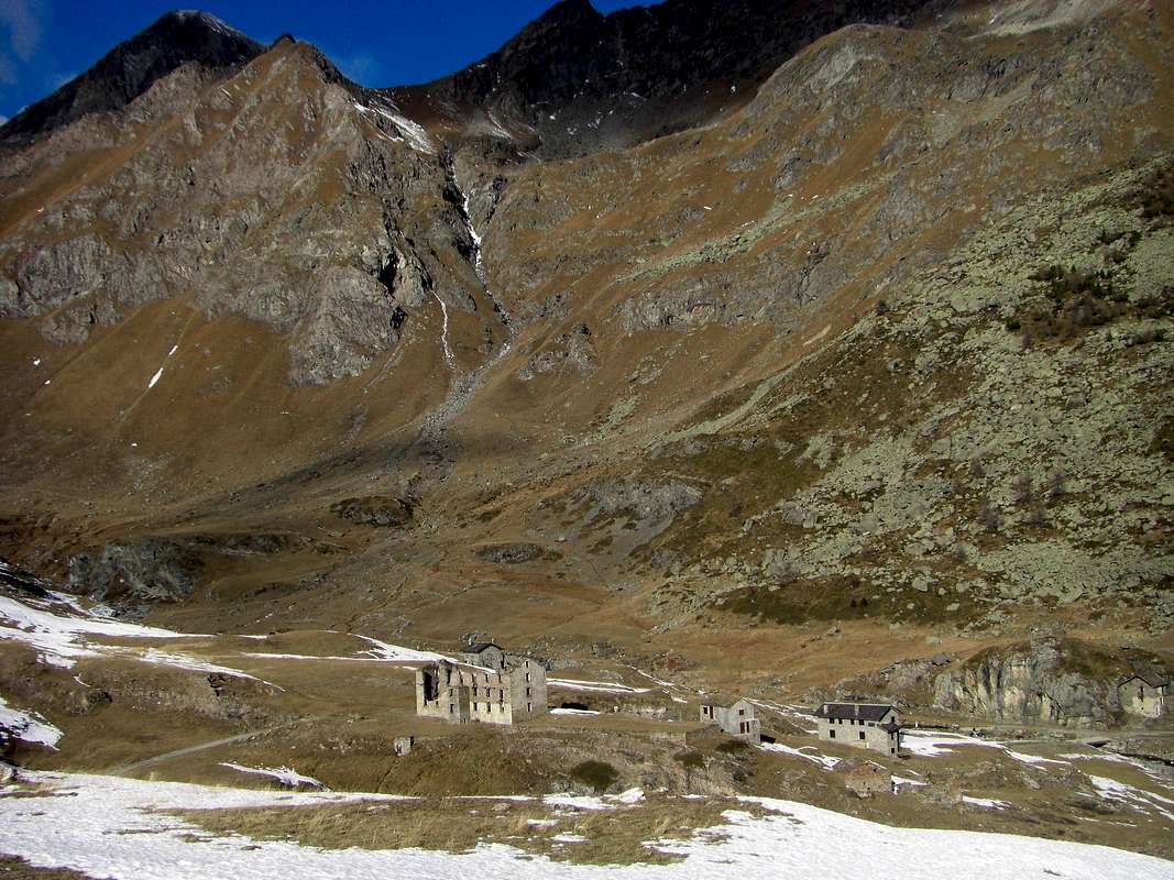
![]()
Arriving on Dondena Village below Mont Glacier
Approach B (From the Royal dirt Road by Dondena, Lake Bianco Hill to Barbustel Shelter and Great Lake):
from the little Village of La Cort, to continue West-northwest on the Real dirt Road to Dondena Village reaching not very after a small parking lot near and along the same one (1.830/40m around; noumerous signs and entry in the Park of the Mount Avic). To begin awry immediately with the path n° 10 that part (North) and it goes up again with a steep zigzag bringing itself, with direction Northeast, at first toward a small secondary torrent and subsequently placing side by side that more important descendant from the impending Lake Muffé. To go up again along the bank right hydrographic of the same one with the path, almost mule-track, that unties him with a series of hairpin bends flanking the wood, alternate to rectilinear lines in diagonal. To go out, leaving on the right (East) the deviation for the La Grand Cort Pasture (1.944m, that from he is quietly seen here, abandoned among green pastures) so in the superior tableland in her narrowing among the appendixes of the Mount Ros (2.289m) to West and you it terminal of the Southwestern Crest that it climbs to the Point Perche (2.396m; also with the toponym of Perché, or Perforated), or Southern shoulder of the Cima Piana (Plain Top also called Mont de Panaz 2.512m). Continue on the vallon floor through less steep slope with run mostly "open" and, abandoning on the left (West) the deviations for the Loch Vernouille (2.145m) with the paths n° 9C/10B and, momentarily, also the path n° 10, to climb with the n° 10C reaching the ruin of the ancient Muffé Alpage (2.076m), close to the homonym Lake suffered to East I approach (2.119m; 0h'30). From this to ascend up with direction Northwest in a area even more disclosed among small backs with lawns and moraines (small sources that gush out a little everywhere) again meeting the base path n° 10, that it originates from the Vernouille Loch, few more than hundred metres more aloft. To abandon therefore the aforesaid variation continues with, that continues in opposite (Northeast) toward the nearby Lago Bianco Hill (2.308m), and to proceed with this last I pour the neighbour Col de la Croix (2.287m), reaching it with a final line of a more steep. A short descent leads quickly to the Refuge Barbustel, at Lake Bianco in the Upper Vallon of Champdepraz also Lakes Vallon (E; 1h'15/1h'45).
Avvicinamento B (Dalla Strada Reale per Dondena, Colle del Lago Bianco verso il Rifugio Barbustel ed il Gran Lago):
Dal piccolo Villaggio di La Cort, continuare verso Ovest-nordovest sulla sterrata Strada Reale Dondena raggiungendo non molto dopo un piccolo parcheggio presso e lungo la medesima (1.840/50 m~; nunerose segnalazioni all'ingresso nel Parco del Monte Avic); iniziare con il sentiero n° 10 che prende inizio subito a monte (Nord) e risale con un ripido zig-zag portandosi, con direzione Nordest, dapprima verso un torrentello secondario e successivamente affiancando il più importante, discendente dal soprastante Lac Muffé. Risalire lungo la sponda idrografica destra del medesimo con il sentiero, quasi mulattiera, che si snoda con una serie di tornanti affiancando il bosco, alternati a tratti rettilinei in diagonale. Uscire, lasciando sulla destra (Est) la deviazione per l'Alpe La Grand Cort con i suoi verdi pascoli (1.944 m) così nell'altipiano superiore nella strettoia tra le appendici del Mont Ros (2.289 m) ad Occidente e la propaggini terminali della Cresta Sudovest risalente alla Cima Perche (2.396 m; o Perché, cioé Forata), o spalla Meridionale della Cima Piana o Mont de Panaz (2.512 m). Continnuare sul fondo del vallone con percorso alquanto meno ripido e maggiormente "aperto" e, abbandonando sulla sinistra (Ovest) le deviazioni per il Lac Vernouille (2.145 m) con i sentieri n° 9C/10B nonché, momentaneamente, anche il sentiero n° 10, risalire tramite il sentiero n° 10C raggiungendo i ruderi dell'Alpeggio Muffé (2.076 m), vicino all'omonimo Lago, subito ad Est appresso (2.119 m; 0h'30). Da questo proseguire con direzione Nordovest in una zona ancora più dischiusa tra piccoli dossi con prati e morene (piccole sorgenti che sgorgano un poco dovunque) incontrando nuovamente il sentiero n° 10, proveniente dal Lac Vernouille, poco più di un centinaio di metri più in alto. Abbandonare quindi la variante seguita, che continua in opposta direzione (Nordest) verso il Col de la Croix (2.387 m), e continuare con quest'ultimo verso quello del Lago Bianco (2.308 m), raggiungendolo con un tratto finale di poco più ripido. Una corta discesa conduce in breve tempo al Barbustel, presso il Lago Bianco nel Vallone Superiore di Champdepraz conosciuto anche come Vallone dei Laghi (E; 1h'15/1h'45).
![]()
Arriving on Lago Bianco Hill above Barbustel Refuge
Approach C (From Voella Fraction in Chalamy Vallon, above Champdepraz):
from the Hamlet of La Ville-Veulla through the farm road to the "Magazine" until the junction for Pra Oursì Pasture, at an altitude of 1.340 meters; go in the direction of West passing a first torrent and a second reaching the pasture at an altitude of 1.791 meters (1h'15). From Pra Oursì Pasture definitely changing direction towards the South to reach the path that leads through, first the path that leads from the "Warehouse" and then into the gorge central halls Volla or Vallon of Chalamy. From this junction continue through the path n° 5C/Alpine Via which dates from the same passing neighbor Serva or Selva Loch (1.801m), just below the incumbent walls of Bec l'Espic (2.355m). Past the inlet, the trail continues to the south below a ridge, beyond which, after a bend, reach Alpe Bayet (2.071m); from this point it is mostly in the southeast and crossed the stream that comes down from White Lake, with low down to the Alp Cousse (2.051m). Returning to South Barbustel finally arrive at the refuge, located in a beautiful rocky plateau between White Lake and Lake Vallette and just below the Hills of Lago Bianco and de la Croix Champorcher (EE; 3h'15/3h'30).
Note: be careful which bypasses the area, not to lose the trail that stretches between the Alps Bayet Cousse (especially downhill or in the dark), because you could go too the Northeast in an area of steep rocky plates with rhododendrons. Unpleasant personally experience already made back in 1983 by M. Avic/M. Iverta under the storm.
Avvicinamento C (Dalla Frazione di Voella nel Vallone di Chalamy al Rifugio Barbustel):
Dalla Frazione di La Ville-Veulla, per la strada poderale verso il "Magazzino" sino al bivio per Pra Oursì a quota 1.340 m; salire con direzione Ovest superando un primo torrentello ed un secondo raggiungendo l'alpeggio a quota 1.791 m (1h'15). Da Pra Oursì, cambiando decisamente direzione verso Mezzogiorno, raggiungere, tramite il sentiero di collegamento, dapprima il sentiero che sale dal "Magazzino" e successivamente inoltrarsi nel vallone centrale che sale da Volla o Vallone di Chalamy. Da questo bivio proseguire per mezzo del sentiero n° 5C/Via Alpina che risale il medesimo transitando verso Sudest al Lago della Serva o Selva (1.801 m), al di sotto delle imponenti pareti Nordorientali del Bec l'Espic (2.355 m). Attraversato l'immissario, il sentiero prosegue verso Sud al di sotto di un costolone, oltre il quale, dopo un ansa, raggiunge l'Alpe Bayet (2.071 m); da questo punto si porta maggiormente a Sudest e, attraversato il Torrente che scende dal Lago Bianco, con modesta discesa raggiunge l'Alpe di Cousse (2.051 m). Rientrando a Sud infine arriva al rifugio Barbustel, posto in una splendida spianata rocciosa tra il Lago Bianco ed il Lago Vallette e subito al di sotto dei Colli del Lago Bianco e de la Croix per Champorcher (EE; 3h'15/3h'30).
Nota: fare attenzione, misconoscendo la zona, a non perdere il sentiero nel tratto tra le Alpi Bayet e Cousse (soprattutto in discesa o al buio), perché si rischia d'andar troppo a Nordest in un'area di ripide placche rocciose con rododendri. Personale spiacevole esperieza già fatta nel 1983 tornando dal M. Avic/M. Iverta sotto il temporale.
![]()
Arriving on Magazzino Village below Mont Avic
Approach D (from Fénis-Barche through Clavalité Vallon:
From Fénis little town (Barche Village 607m) along the dirt road (no access mark), after Lovignana (1.162m - 9km) that, boarding the Clavalitè Stream ascends the whole valley up to the Baite di Grand Alpe (2.120m), at the beginning of the Comba Tersiva, under the Fénis Pass (2.857m). From the pastures toward East along the path n° 102 up to the Cuneu stabling buildings (2.156m), near the new Bivouac E. Borroz of Clavalité Rotary. Leaving in left (North) the ground road to Etsely Damon (2.434m), in quota (2.156m), near Cuneu's also Cuneux Alp (2.156m), continue, by Southeast direction and path n° 5C,5D up to the an alternative of paths immrdiately after of the La Tramouaille-de-Cuneux or Tramouail, otherwise the more raised Alp and, after the abandon right the path 5D to Moutsaillon Pass, reach the same. With route more in East-southeast through a morainic small vallon to arrive on Fussì Hill; by a short descent of twenty meters reach the previous Approach A from Dondena Village (4h'45/5h'00 from Barche; 3h'30/4h'00 from no thoroughfare near Lovignana Pasture). Otherwise, see Variant below, just longer but with definitely more scenic route through a very ancient route ("Hunters Via").
Variation: from Cuneux or Bivouac of Rotary you can, via the private road towards the North, reaching the Tramouaille-de-L'Echellier or, for the locals, Etsely (2.437m). From this last alp the following path n° 5/102, initially oriented to the East and then South-east leads near the watershed between the Etsely (North) and Fussì Passes; a variant n° 5A reaches this last passing below the dividing crest with Lac Glacier (2.935m) via a diagonal towards the South-southeast over an old mule-track (a quarter hour later).
Avvicinamento D (da Fénis-Barche attraverso il Vallone della Clavalité:
Partendo da Fénis, (località Barche 607 m), percorrere la lunga strada poderale (palina di divieto dopo Lovignana; (1.162 m, dopo 9 Km) che, costeggiando il Torrente Clavalité, risale l'intera omonima valle sino alle Baite di Grand Alpe (2.120 m), all'inizio della Comba Tersiva, sottostante il Colle di Fénis (2.857 m). Dall'Alpeggio seguire verso E il sentiero intervallivo n° 102 fino alle baite superiori del Cuneu o Cuneux od ancora Cuneus (2.156 m), al di sopra delle quali da poco è stato edificato il Bivacco E. Borroz del Rotary Clavalité. Continuare verso Sudest lasciando a sinistra (Nord) la strada poderale per l'Alpeggio Etsely Damon (2.434 m), in quota (2.156 m), presso l'Alpe del Cuneux. Con il sentiero n° 5C,5D e stessa direzione Sudest, continuare fino ad un bivio subito prima di La Tramouaille-de-Cuneux o Tramouail, ovvero l'alpeggio più elevato e, dopo aver lasciato sulla destra il sentiero 5D che si indirizza al Col Moutsaillon, raggiungerla. Con percorso più ad Est-sudest in un valloncello morenico pervenire al col Fussì; una discesina d'una ventina di metri riallaccia al precedente Avvicinamento A (4h'45/5h'00 da Barche; 3h'30/4h'00 dal divieto di Lovignana). Oppure, vedi sotto, con l'antica "Via dei Cacciatori".
Variante: dal Cuneux si può, tramite la poderale verso Settentrione, raggiungere La Tramouaille-de-L'Echellier o, per gli abitanti locali, Etsely (2.437 m). Da quest'ultima alpe il successivo sentiero n° 5/102, orientato dapprima ad Est e poi Sudest, conduce nei pressi dello spartiacque tra i Colli dell'Etsely (Nord) e Fussì; una variante n° 5A raggiunge quest'ultimo passando al di sotto della cresta divisoria e del Lac Glacier (2.935 m), con diagonale verso Sud-sudest su d'una antica mulattiera (circa un quarto d'ora in più).
![]()
Arriving on crossroads Grand'Alpe/Etsely Pastures
![]()
Arriving on South-southwest Slope and final South Crest or Normal Route
Dondena to continue at the moment along the path n° 8B for the Moussaillon Pass (2.853m), leaving the same to the leftt (Northeast) and continue with that (path n° 8C) for the Pass Fussì and nearby Mount Glacier, with a double diagonal between two series of hairpin bends leading to a large saddle around 2.900 meters altitude on a rocky promontory at the base of the Eastern Face of Mont Delà (3.139m). Initially trace for a short time against the walls of this and later, Via a short diagonal down to North, move towards Fussì Pass (2.910m) passing high above Lake Gelato (2.824m) and arriving immediately below the same. From this point the path, with semi circular course under the Southwest Ridge, through an area of large, rotten and broken blocks alternating with stretches of fine debris and then, heading further East, climb a steeper slope, boring and tiring reaching the great Southwest Shoulder (3.003m) immediately on your left (North) of the same; this changing completely the direction towards the North-northwest through the terminal part of South Crest reaches the East Ridge, which rises from the two Hills of the Grande Rossa, in its final part and, through this, with easy rocks addressed West you can easily reach the Summit (EE/F; 3h'15). This path is easy, but in the case of snow, requires attention in the section between the saddle of entry into the vallon, the long crossing to the Col Fussì, that under the South Slope and ascent below the big shoulder (always with considerable avalanches and snowslides danger).
Dal Villaggio di Dondena proseguire momentaneamente lungo il sentiero n° 8B per il Colle Moussaillon (2.853 m), lasciandolo a sinistra (Nordovest) e proseguire con quello (sentiero n° 8C) per il Col Fussì ed il vicino Mont Glacier, con un doppio diagonale tra due serie di stretti tornanti che conduce ad una larga sella quota 2.900 metri circa su d'un promontorio roccioso alla base della Parete Est del Mont Delà (3.139 m). Dapprima risalire per breve tempo contro le pareti di questo ed in seguito, tramite un corto diagonale in discesa verso Nord, portarsi in direzione del Col Fussì (2.910 m) passando alti sopra il Lago Gelato (2.824 m) ed arrivando immediatamente al di sotto del medesimo. Da questo punto il sentiero, con percorso semi circolare sotto la Cresta Sudovest, attraversa una zona di grandi blocchi alternata a tratti di fine detrito per poi, dirigendosi maggiormente ad Est, risalire un pendio più ripido, noioso e faticoso raggiungendo lo Spallone Sudovest (3.003 m) subito sulla sua sinistra (Nord); da qui cambiando, completamente direzione verso Nord-nordovest, tramite la parte finale della Cresta sud raggiunge la Cresta Est, che sale dal doppio Colle della Gran Rossa, nella sua parte finale e, tramite questa, con facili roccette si giunge facilmente alla Sommità (EE/F; 3h'15). Questa via é facile ma, in caso di neve alta, richiede attenzione nel tratto tra la sella d'ingresso nel vallone, la lunga traversata verso il Col Fussì, quella sotto il Versante Meridionale e nella salita al di sotto dello spallone (notevole pericolo di valanghe e slavine).
![]()
From left: South Face, South-southwest Slope & South Crest or Normal Route
in case of snow in the stretch that goes back to the great Southwestern Shoulder (3.003m), usually at the beginning of the season or after a recent snowfall, you can go directly to the Summit via the South Face abandoning the right (East) track of the Way Normal. When the latter starts the diagonal, after the Fussì Hill, go up a fairly steep snowfield directly to the base of the Southern Slope; bring in the shelter of some plaques gray crossed by a large reddish spot. Circumvented the same just to the right (East), continue on a slope of broken rock, covered with debris and unstable materials, which leads more or less directly to the Top, searching for the path between ledges and small walls. So myself with Gianfranco Vicentini June 20th, 1999 (I°+/II°/II°+, wanting even more) without fixed course (EE/A/F+/PD-; 3h'30/4h'00).
Via B Variante Diretta alla Normale tramite la Faccia Sud:
in caso di neve alta nel tratto che sale alla grande spalla Meridionale (3.003 m), in genere ad inizio di stagione oppure dopo una recente nevicata, si può salire direttamente alla Sommità tramite la Faccia Sud abbandonando a destra (Est) la traccia della Via Normale. Quando questa ultima inizia il diagonale, dopo il Col Fussì, salire su di un nevaio abbastanza ripido direttamente alla base del Versante Meridionale; portarsi a ridosso di alcune placche grigiastra solcate da una grande macchia rossiccia. Aggirata la medesima appena a destra (Est), proseguire su un versante di rocce rotte, coperte da detriti e materiali instabili, che conduce più o meno direttamente alla Sommità, cercando la via tra cenge e muretti. Così il sottoscritto con Gianfranco Vicentini il 20 Giugno 1999 (I°+/II°/II°+, volendo anche di più) senza percorso obbligato (EE/A/F+/PD-; 3h'30/4h'00).
![]()
Snowy Souhtern Slope, between South & Southeast Crest above Dondena
Route C or from Fussì Hill (always Dondena or Barche through Southwest Crest):
reached the Col Fussì from the Vallon of Savoney or the opposite with a small deviation from the normal, start climbing on rocks that are becoming steeper, reaching a small terrace; pass on the left the next gray slab (II°+/III°; in this section requires the rope) still continuing on steep rocks, but they become progressively easier until a first rounded promontory. From this still easily go to the North with progressive lower slope; once on the Western great Shoulder (around 3.080/90 meters), the crest, and farther to the East, it becomes almost "walkable" (2h'00/2h'30 from the hill). This route, gives the Guide B&V as feasible (often these citations do not correspond to a path actually taken place, but rather an analysis from the bottom), has been made down by Roberto Nicco and his companions in the seventies; uphill path to record an ascent certain by the Guide Valpelline Peter Giglio with his son Matteo and another guy, September 11th, 1994. It is not a difficult, but is certainly not aimed at the mass. It requires precautions.
Via C o del Col Fussì (sempre da Dondena o da Barche per la Cresta Sudovest):
raggiunto il Col Fussì dal Vallone di Savoney o dallo opposto con una piccola deviazione dalla Normale, iniziare a salire su rocce che si fanno sempre più ripide raggiungendo un piccolo terrazzo; superare sulla sinistra la successiva placca grigia (II°+/III°; in questo tratto necessaria la corda) continuando ancora su rocce ripide, che però diventano progressivamente più facili fino ad un primo promontorio arrotondato. Da questo proseguire ancora facilmente verso Nord con progressiva minor pendenza; giunti sullo Spallone Occidentale (circa 3.080/90 metri), la cresta, procedendo più verso Est, diventa quasi "camminabile" (2h'00/2h'30 dal colle). Questa via, che la Guida B&V dà come fattibile (spesso queste citazioni non corrispondono ad un percorso realmente avvenuto ma piuttosto da un'analisi dal basso), é stata percorsa in discesa da Roberto Nicco e compagni negli anni settanta; in salita registriamo un percorso certo da parte della Guida di Valpelline Pietro Giglio con il figlio Matteo ed un altro ragazzo, il 11 Settembre 1994. Non é una via difficile, ma non é di certo rivolta alla massa. Richiede precauzioni all'inizio, dove il primo salto roccioso risulta esposto ed assolutamente da non sottovalutare.
![]()
S-SW Slope or Normal from Dondena, through Gelé or Fenetre Loch & under Fussì Pass
of these four "archaic ways" we only give a short-dashed line, as they have meaning only "historic". Probably never again repeated, and rightly so given the poor things they offer in comparison to their hazard. The first route, directed more toward the South, climb the steep slopes of the Southern which are contained in a circular area just above Dondena Hamlet; the same is limited to the West by the spur which descends from the East Ridge near the altitude of around 3.080/90 meters on the great shoulder (3.003m), leaving in bottom West the Lac Glacé and Fussì Hill, while on the opposite side of a buttress parallel down from the Ridge East at an altitude of about 3.015/20 meters, where it is split by sending a branch to the two Gran Rossa Hills. It is able to divide the basin from that of the Giassit Walloon further East. The first or South Crest was once crossed to reach the shoulder joining the Normal Route on the shoulder (3.003m) and with this conclusion. The vast Southern Slope instead was explored October 6th, 1895 by Felice Mondini, Giulio Toesca Castellazzo and Nicola Vigna with a complicated path that bypasses the second of the two ridges and always ends on the East Ridge; the complex descent took off for the Southern Slope. Another route again, made by Mario Aldrovandi with his wife and Gamekeeper Mountain Guide Vassoney Champorcher in 1924, faces the Face East-southeast to the most Northern of the two steep and generally snowy couloirs, to conclude then more equally. For these routes the same considerations and belong to the past; for all, however, there must be the ability to learn to identify the way (from PD/PD to AD, on average; 3h'30/4h'00 Dondena).
For more clarity and so as not to further increase the confusion we give title to the routes starting clockwise from the Northeast to the Southwest:
East Ridge: this is the Eastern watersheed (see below) that goes from the Western Hill of Gran Rossa; has been covered at least once, down by crossing in 1975. There is no news of uphill and is the Eastern Edge of this extremely large slope that ends at the opposite side of the Southwest Ridge above the Col Fussì.
Face East-southeast (couloir right) and Eastern Edge: Walloon Giassit, diverting to the West from the path that leads to the two Hills of the Gran Rossa (PD/PD+/AD-).
Southeast Ridge: Dondena coming directly from the base in altitude around 2.450/500 meters. This ridge, if covered in full (probably Roberto Nicco and Companions seventies) has passages of I°/II°/III° arriving on the Eastern Edge with which to conclude. The same, but starting from the Vallon Giasset, had already been reached by the group in 1895 through a steep gully; from this, with long crossing to the West slopes of the South Face, had reached the opposite Crest South below the great shoulder and concluding with the Normal Route (PD-/PD+/AD-). In the first climb the ridge by Dondena was reached from the West to a grassy couloir that comes to about 2.700 meters.
South Face: the same roped above with "adventurous" descent returning with the ascent up in the middle of the vallon and then directly down "untangling" between small rock walls alternating large and steep rock slabs. Then the slope is only partially path and in the medium-low (PD/PD-/F+/F). The top seems more dangerous that difficult.
Crests South and East: is covered in the last section, the easiest, the Normal. The group rope climbers also traveled in 1895 the middle part, but not completely (PD-/F).
Southwest Side, Ridges South and East or Normal Route Dondena: corresponds to the current Standard Route, in North to the Dondena Village, that passes by La Gelé passing below the Col Fussì then be directed to the great shoulder (3.003m) (F). ( *** all these routes are well identifiable until the Cresta South in pictured below).
![]()
From left: S Crest, S Slope, SE Crest, E-SE Face, E Ridge, NE Wall & N-Ne Edge
Via D pel Vallone del Giassit (sempre da Dondena tramite i Versanti o le Creste Meridionali eppure tramite la Faccia Est-Sudest):
di queste quattro "arcaiche vie" diamo soltanto un breve tratteggio, poiché hanno esclusivamente in significato "storico". Probabilmente mai più ripetute, giustamente in considerazione delle scarse attrattive che offrono in confronto alla loro pericolosità. Il primo itinerario, rivolto più verso Sud, sale i dirupati pendii Meridionali che sono contenuti in un comprensorio circolare proprio al di sopra di Dondena; lo stesso é limitato ad Ovest dal contrafforte, che scende dalla Cresta Est a quota 3.080/90 metri circa sullo spallone (3.003m) lasciando in basso ad Ovest il Lac Glacé, mentre sul lato opposto un contrafforte parallelo scende dalla Cresta Est a quota 3.015/20 metri circa, dove questa si sdoppia inviando un ramo verso i due Colli della Gran Rossa. Risulta atto a dividere questo bacino da quello del Giassit più ad Est. La prima o Cresta Sud veniva una volta oltrepassata per raggiungere la spalla congiungendosi alla Via Normale sullo spallone e con questa concludere. Il vasto Versante Meridionale invece é stato esplorato il 6 Ottobre 1895 da Felice Mondini, Giulio Toesca di Castellazzo e Nicola Vigna con un percorso complicato che scavalca la seconda delle due creste e termina sempre sulla Cresta Est; la complessa discesa avvenne per il largo Versante Meridionale. Un'altra via ancora, effettuato da Mario Aldrovandi con la moglie e la Guida Guardiacaccia Vassoney di Champorcher nel 1924, affronta la Faccia Est-sudest per il più Settentrionale dei due canaloni innevati, concludendo poi sempre in modo uguale. Per queste vie valgon le stesse considerazioni ed ormai appartengono al passato; per tutte comunque deve sussistere la capacità di saperne individuare la via (da PD-/PD ad AD-; in media 3h'30/4'00 da Dondena).
Per maggior chiarezza ed onde non aumentare ancor di più la confusione diamo titolo alle varie vie partendo in senso orario dal Nordest verso Sudovest:
Cresta Est: trattasi dello spartiacque Orientale (vedi sotto) che sale dal Colle Occidentale della Gran Rossa; é stata percorsa almeno una volta, in discesa con traversata nel 1975. Non si hanno notizie di percorsi in salita e costituisce il margine Est di questo oltremodo largo versante concludentesi all'opposto con la Cresta Sudovest sul Col Fussì.
Faccia Est-sudest (canalone di destra) e Cresta Est: dal Vallone del Giassit, deviando ad Ovest dal sentiero che porta ai due Colli della Gran Rossa (PD/PD+/AD-).
Cresta Sudest: direttamente da Dondena arrivando alla base a quota 2.450/500 metri circa. Questa cresta, se percorsa integralmente (probabilmente Roberto Nicco e Compagni anni settanta) presenta passaggi di I°/II°/III° arrivando sulla Cresta Est con la quale concludere. La stessa, ma partendo dal Vallone del Giasset, era stata già raggiunta dalla comitiva del 1895 tramite un ripido canalone; da questa, con lunga traversata verso Ovest alle pendici del Versante Sud, avevano raggiunto l'opposta Cresta Sud sotto lo spallone e concludendo con la Normale (PD-/PD+/AD-). Nella prima salita la cresta fu raggiunta da Ovest per un canalone erboso che arriva a circa 2.700 metri.
Versante Meridionale: la stessa cordata di cui sopra con "avventurosa" discesa ritornando con la via di salita fino nel mezzo del vallone per poi calare direttamente verso il basso "districandosi" tra muretti roccia alternati a grandi e ripide lastre. Quindi il versante risulta solo parzialmente percorso e nella parte medio-bassa (PD/PD-/F+/F).
Creste Sud ed Est: viene percorsa nell'ultimo tratto, il più facile, dalla Via Normale. La cordata del 1895 la percorse anche nel tratto medio, ma non completamente (PD-/F).
Versante Sudovest, Creste Sud ed Est o Normale: corrisponde all'attuale via, che transita dal Lago Gelato passando al di sotto del Colle Fussì, per poi indirizzarsi allo spallone (3.003 m) sulla Cresta Sud concludendo con quella Est (F). ( *** queste vie sono ben identificabili fino alla Cresta Sud nelle due foto sopra e sottostanti).
![]()
From left: S Crest, S Slope, SE Crest, E-SE Face, E Ridge & NE Wall
Route E Through the Grand Rossa two Hills (Eastern "Crestone" by Giasset Vallon):
Dondena upper parking continuous toward North reaching the Alp of the Giasset, where it finishes (2.057m); to continue with the path n° 9C more toward Northeast reaching the homonym pond (2.308m; T; 0h'30). From this, taking to the left (North) a slender trace along the frontally floor vallon that is addressed toward the two Hills of the Gran Rossa. From this, taking to the left (North) a slender trace that is addressed on the fund of the before vallone toward the two Necks of the Gran Rossa (SW 2.786m; NE 2.763/66m around), and to reach the loeast to the beginning of the West Crest; from this step over the next two-headed rock or cross the same at the base to the South (even better to reach directly under the Western Hill). From the Hill Southwest, with climbing fairly easy to achieve a first collar consists of bluish rock (2.786m). The next section, more challenging (I°+/II°; outflanked to the North of ledges with soil), leading to the shoulder 3.003 meters, where the ridge is divided by posting a branch in South-east towards the bottom of the Walloon of the Giassit. This sector is made up of large rocky crags that it is better to climb the ridge being formed by rock route and quite friable (also wanting II°+/III -). From the junction continue much more easily to the Summit (F+/PD-; 1h'00/1h'15 from Northeast Hill; 2h'30/3h'00 from Dondena).
Via E dai due Colli della Gran Rossa (sempre dal Giassit tramite il "Crestone" Est):
dal parcheggio superiore con varie segnalazioni appena prima della discesa a Dondena continuare invece sulla destra per breve tratto con la strada in terra battuta che, oltrepassato un secondo più piccolo parcheggio, invita a portarsi verso Nord raggiungendo l'Alpeggio del Giasset, ove termina (2.057 m); proseguire invece con il sentiero n° 9C più verso Nordest raggiungendo l'omonimo laghetto (2.308 m; T; 0h'30). Lasciando a destra (Est) il sentierino per il Colletto Giasset (2.400 m~) che conduce al viciniore Lago del Raty nell'omonimo Vallone, prendere a sinistra (Nord) un'esile traccia, indirizzantesi tra pietraie e campi erbosi sul fondo dell'antistante valloncello alle pendici Orientali del Mont Glacier, verso i due Colli della Gran Rossa (SO 2.786 m; NE 2.763/66 m). Raggiungerne il più basso posito subito all'inizio della Cresta Ovest della Gran Rossa; da questo scavalcare le due teste rocciose successive od attraversar le stesse alla base verso Sud (ancor meglio raggiungere da sotto direttamente il Colle Occidentale). Dal colle Sudovest, con arrampicata abbastanza facile, raggiungere un primo colletto formato da rocce bluastre (2.786 m). Il tratto successivo, leggermente più impegnativo (I°/II°; aggirabile a Nord su cenge con terriccio), conduce alla spalla 3.003 metri, dove la cresta si divide inviando un ramo a Sudest verso la parte inferiore del Vallone del Giassit. Questo settore é formato da notevoli spuntoni rocciosi che é meglio arrampicare sul filo di cresta essendo formati da roccia rotta e piuttosto friabile (volendo anche II°+/III°-). Dalla congiunzione proseguire decisamente in modo più facile fino alla Sommità (F+/PD-; 1h'00/1h'15 dal Colle Nordest; 2h'30/3h'00 dal Villaggio di Dondena).
from the Refuge Barbustel recently built (2.209m), located midway between the Lac Blanc and Lac Vallette (2.132m, 2.170m; 0h'15). From this trace the beautiful and wild Vallon Lake, in the Upper Valley of Champdepraz and, with the trail n° 6/102, pass in succession the White Lake (2.132m), through a short descent, Nero (2.166m) and Cornuto (Horned; 2.168m), passing just above their edges and reaching the Northern Alpage Pisonet (2.301m), located in a beautiful clearing at the end of this first part of the walloon below and a distinctive and overhanging rocky promontory. From this, the same, which gradually turns into beautiful trail, from the West turned decidedly first in the South and then back again to the West the slope with a dozen hairpin bends to stand at Grand Lake (2.485m; 1h'45/2h'00). The same appears to be the most extensive of all the Valley of Aosta and the beginning of the second and higher part of the vallon. Flanking its Northern shore is reached at a waterfall (great place to eat), its tributary and immediately below the Bivouac Verthuy of the Forest (2.535m; private and always closed), amid a cluster of lakes called the Leità (E; 1h'30/2h'00 from Barbustel). From the Great Lake through moraines, immediately after rounding to the right (North) a small rocky promontory above the inlet to reach the three small Lakes Leità (2.564 m); from the top of these continue to the South in a narrow walloon and increasingly steep scree or through snowfields reach with a small dirt track at the end of the Gran Rossa Hill Northeast (2.763/6m), whence the Summit with previous D Route by Eastern Ridge (A/F+/PD-; 1h'00/1h'15 from more Eastern Hill; 4h'00/4h'15 from Barbustel Shelter).
dal Rifugio Barbustel di recente costruzione (2.209 m), sito a metà strada tra il Lac Blanc ed il Lac Vallette (2.132 m, 2.170 m; 0h'15). Da questo risalire lo splendido e selvaggio Vallone dei Laghi, nell'Alta Valle di Champdepraz e, con il sentiero n° 6/102, oltrepassare in successione i Laghi Bianco (2.132 m), tramite una discesina, Nero (2.166 m) e Cornuto (2.168 m), transitando poco al di sopra dei loro bordi Settentrionali e raggiungendo l'Alpe Pisonet (2.301 m), sita in una bella spianata al termine di questa prima parte del vallone e sottostante ad un caratteristico promontorio roccioso. Da questa il medesimo, che progressivamente si trasforma in bella mulattiera, da Ovest volge decisamente dapprima a Sud e risale quindi nuovamente verso Ovest l'erta con una dozzina di stretti tornanti portandosi al Gran Lago (2.485 m; 1h'45/2h'00). Il medesimo risulta come il più esteso di tutta la Valle d'Aosta ed all'inizio della seconda e più elevata parte del vallone. Fiancheggiando la sua sponda Settentrionale si raggiunge, presso una cascatella (ottimo posto di ristoro), il suo immissario e subito appresso il Bivacco Verthuy della Forestale (2.535 m; privato e chiuso), sito tra un nugolo di laghetti detti della Leità (E; 1h'30/2h'00 dal Barbustel). Dal Gran Lago tramite morene, subito dopo aver doppiato a destra (Nord) un piccolo promontorio roccioso soprastante l'immissario, raggiungere i tre piccoli Laghi Leità (2.564 m); dal superiore tra questi continuare verso Mezzogiorno in uno stretto vallone e per pietraie sempre più ripide o per mezzo di nevai raggiungere con una piccola traccia in terriccio nella parte finale il Colle Nordest della Gran Rossa (2.763/6 m) oppure il Sudovest, donde alla Sommità con la precedente Via D tramite l'abbastanza lunga Cresta Orientale (A/F+/PD-; 1h'00/1h'15 dal Colle più Orientale della Gran Rossa; 2h'00/2h'15 dal Gran Lago; 4h'00/4h'15 dal Rifugio Barbustel).
![]()
From left: E Ridge, NE Wall, N-NE Edge, NW Face, SW Ridge
Various Routes G on the North-northeast Face (from the Shelter Barbustel through the Great Lake):
always starting from the Western Side you can climb the Wall East-northeast, leaving to the left (Southeast) the via that leads to the hills of the Gran Rossa or a crossing to the left from near Medzove Pass (2.614m). On this wall there is a history of "old" and the other "modern". In "Guide R.A.V.A" by Mario Aldrovandi, Lattes Turin 1931 Edition and Carlo Fanton Turin 1964, pages 149 and 194, speaking of the eleven gullies Mont Glacier the Author mentions a descent via the Northeast, after rising for the North Slope with his wife accompanied by a Mountain Guide and Gamekeeper Champorcher Vassoney in 1924. it is not given to know the exact route that presumably should take place along the Eastern most of the small couloirs that descend from the Eastern Ridge, just before a triangular rock face. We're not here to "split hairs" in the search for a "Lost Way" leaving the three protagonists of the first path on the same. However, it is only right to point out that a second "exploratory phase" has been taken up by young local climbers with the ascent of the Central Couloir by Pietro Bosonetto and Elio Vittaz in June 1979; the same route has been re-covered the June 8th, 1986 by the three brothers Bastrentaz with Paolo Zappa. But the first had already repeated facing the East Side of the Spur North-northeast, so with a completely off the rock to the right of and below the previous one on the Corner North-northeast in 1915, of which we will discuss below. In any case, all three paths, except the edge, are dangerous for the considerable amount of suspended material, also depending on the condition of snow or ice (from AD to D for the three routes; 2h'00 approximately from the base). Vie however inadvisable that, in any case more "enhance" the descent performed in 1924, also "logical" for faster and therefore less vulnerable to rock falls (see photo Overview).
Varie Vie G sulla Parete Nord-nordest (dal Rifugio Barbustel tramite il Gran Lago):
sempre partendo dalla sponda Occidentale si può salire la Parete Est-nordest, lasciando a sinistra (Sudest) la via che conduce ai colli della Gran Rossa oppure con una traversata verso sinistra dal vicino Col Medzove (2.614 m). Su questa parete esiste una storia "antica" ed un'altra più "moderna". In "Guida della R.A.V.A." di Mario Aldrovandi, Edizione Lattes Torino 1931 ed Ed. C. Fanton Torino 1964, pagine 149 e 194, parlando degli undici canaloni del Mont Glacier l'Autore accenna ad una discesa tramite quello Nordest, dopo essere salito per il Versante Est con la moglie accompagnati dalla Guida e Guardiacaccia di Champorcher Vassoney nel 1924. Non é dato da sapere il preciso itinerario che, presumibilmente, dovrebbe svolgersi lungo il più Orientale tra i piccoli canali che scendono dalla Cresta Est, appena prima di una triangolare parete rocciosa. Non stiamo qui a "sottilizzare" nella ricerca di una "Via Perduta" lasciando ai tre protagonisti dell'epoca del primo percorso sulla medesima. Doveroso é però sottolineare che una seconda "fase esplorativa" é stata ripresa da giovani alpinisti locali con la salita del Canalone centrale da parte di Pietro Bosonetto ed Elio vittaz nel Giugno 1979; la stessa via é stata nuovamente percorsa l'8 di Giugno 1986 da parte dei tre fratelli Bastrentaz con Paolo Zappa. Ma i primi si erano già ripetuti affrontando il lato Orientale dello Sperone Nord-nordest, quindi con una via completamente in roccia a destra della precedente e subito sottostante quella sullo Spigolo Nord-nordest del 1915, de quale tratteremo appresso. In ogni caso tutti e tre i percorsi, tranne lo spigolo, sono pericolosi per la notevole quantità di materiale sospeso, dipendendo inoltre dalla condizione della neve o del ghiaccio (da AD a D per i tre itinerari; 2h'00 circa dalla base). Vie comunque sconsigliabili che, in ogni caso "esaltano" maggiormente la discesa (più logica) effettuata nel 1924.
North-northeast Edge in ascent, Western Ridge in descent towards two Gran Rossa Pass, with traverse to Gran Rossa, 1975
Route H on the North-northeast Edge (from the Shelter Barbustel through the Great Lake and the Medzove Pass):
from the Great Lake to the Northwest to continue for a short distance to reach the Bivouac of the Forest with trail n° 6/102; allowing the continuation of this North-northwest towards the Plateau of Great Betassa, continuing instead take the path Intervalleys n° 102 to the Southwest, which in the end becomes a track, reaching the Col Medzove or Mezove (2.614m; E; 0h'30 by Grand Lake; 1h'45/2h'00 from Barbustel). Start the climb up some traces reaching a bump in altitude 2.849 meters followed by a collar rock; should always follow the ridge for every 350 meters of the climb, facing a series of rocky plates much broken and covered with debris. Nevertheless, the climbing is enough fun, safe and almost always easy (steps I° and II°) to reach the Summit (PD/PD-; 1h'00 from the base; 3h'00 Barbustel; 4h'30/5h'00 Mont Blanc Champorcher).
dal Gran Lago continuare verso Nordovest per breve tratto raggiungendo il Bivacco della Forestale con il sentiero n° 6/102; lasciando la continuazione di questo a Nord-nordovest verso l'altopiano della Gran Betassa, continuare invece a Sudovest con il sentiero Intervallivo n° 102, che nella parte finale diventa una traccia, raggiungendo il Col Medzove o Mezove (2.614 m; 0h'30 dal Gran Lago; 1h'45/2h'00 dal Barbustel). Iniziare la salita su qualche traccia raggiungendo un'asperità in altitudine 2.849 metri seguita da un colletto roccioso; conviene seguire sempre il filo di cresta per tutti i 350 metri circa della salita, affrontando una serie di placche rocciose molto rotte e ricoperte da detriti. Ciononostante la salita risulta abbastanza divertente, sicura e quasi sempre facile (passaggi di I° e II°) fino a raggiungerne la Sommità (PD/PD-; 1h'00 dalla base).
![]()
Left: E Ridge, NE Wall, N-NE Edge, NW Face, NW Crest, W-NW Slope & SW Crest
Route I North Wall (from the Vallon of Savoney):
This large wall of trapezoidal shape is perfectly situated between the North-north-east Edge and a long Western Ridge on the watershed that divides Clavalité Walloon from the secondary Savoney, at the top of the head thereof, located between the divide down to the Mont Avic and Mont Rafray with its horrid couloirs. Formed by a large wall behind you as high as you which narrows, is divided in its middle by a rock band that is the "crux", which can be reached via a steep rocky slope that is wedged in the interior thereof. High nearly 600 meters, is formed on its left (West) from a wall of rocks very dangerous and routes that go to "fade" against the edge becoming one with the same, while on the opposite side with a band rocky slopes that reaches the basal rocks. It is uphill once, in its central part, passage of two rock bands rather "irksome" and very exposed to falling rocks, existing over much suspended matter. In this case we have to approach it with connection the way, starting with a deviation that occurs from the Walloon of the Clavalité to Southeast; in fact arrived at a crossroads 1.551 meters immediately after Bioley Damon needs to continue with the path n° 4, concomitant with the private farms dirt road up to the Pastures of Crin and Bayette of Meitin (Middle; 1.642m), where it ends. The trail continues, with the same direction but bending to the South, towards Alp Orgère (1.750m); the final stretch leads, after crossing the Torrent Cavoney, Alp of Savoney (2.129m) and to the next of Mezove (2.390m) at the East foot of Mont Rafray. In a short time you can reach the nearby Lake Margheron or Medzove (2.377m) and continuing for a short distance along path n° 5C to the pass of the same name, will soon leave it and go on devastated rocks towards the miserable remains of a ancient glacier at the base of the face. With rising progressively steeper come to the bottom of it sticking in its midst; directly overcome a series of small rock bands (I°+ /II°-/II°, or circumventing the same more to the West) to reach the "heart" of the face. A gully of scrap (II°+, around 35/40 meters) leads to a terrace debris, sometimes with residues of hard snow; avoiding a rock band more consistent on the left (East), adressed directly towards the Summit through a variety of fairly steep rock slabs with many outstanding and gravels (PD+/AD; 3h'30/4h'00 from base; 4h'30/5h'00 from the junction Bioley Damon; 6h'30/7h'00 Lovignana). Ascension that requires training and experience.
Questa larga parete di forma perfettamente trapezoidale é situata tra lo Spigolo Nord-nordest ed una lunga cresta Ovest spartiacque, che divide il Vallone di Clavalité da quello secondario di Savoney, al sommo della testata del medesimo, posto tra lo spartiacque che scende verso il Monte Avic ed il Mont Rafray con i suoi orridi canaloni. Formata da una larga parete alla base che più in alto si retringe, é divisa nella sua metà da una fascia rocciosa che costituisce il "passaggio chiave", alla quale s'arriva tramite un ripido pendio petroso incuneantesi all'interno della stessa. Alta quasi 600 metri, é costituita sulla sua sinistra (Est) da una parete di rocce molto rotte e pericolose che vanno a "smorzarsi" contro lo spigolo diventando un tutt'uno con il medesimo, mentre sul lato opposto digrada con una fascia rocciosa raggiungente le pietraie basali. Risulta salita un'unica volta, nella sua parte centrale, con superamento di due fasce rocciose piuttosto "ostiche" e molto esposte alla caduta di pietre, esistendo al di sopra molto materiale sospeso. In questo caso dobbiamo congiungere l'avvicinamento alla Via, partendo da una deviazione che avviene dal Vallone della Clavalité verso Sudest; giunti infatti al bivio 1.551 metri dopo Bioley Damon devesi proseguire con il sentiero N° 4, concomitante con la strada poderale fino agli alpeggi di Crin e Bayette di Meitin (di Mezzo; 1.642 m), dove la medesima termina. Il sentiero prosegue, con la stessa direzione ma piegando più a Sud, verso l'Alpe d'Orgère (1.750 m); un ultimo tratto conduce, dopo avere attraversato il Torrente de Cavoney, all'Alpe di Savoney (2.129 m) ed a quella successiva di Mezove (2.390 m), alle falde Orientali del Mont Rafray. In breve tempo si raggiunge il vicino Lago Margheron o di Medzove (2.377 m) e, continuando per un corto tratto con il sentiero n° 5C per l'omonimo colle, presto lo si abbandona per dirigersi su scovolte pietraie verso i miseri resti d'un antico ghiacciaio alla base della parete. Con salita progressivamente più ripida, portarsi alla base della medesima attaccando nel suo mezzo; superare direttamente una serie di piccole fasce rocciose (I°+/II°-/II°; oppure aggirandole più verso Ovest) raggiungendo il "cuore" della parete. Un canalino di rottami (II°+, 35/40 metri) conduce ad un terrazzo detritico, a volte con residui di neve dura; evitando tramite una rampa obliqua una fascia rocciosa più consistente sulla sinistra (Est), indirizzarsi direttamente verso la Sommità superando una serie di lastre rocciose abbastanza ripide con molto materiale sospeso e ghiaie (PD+/AD-; 3h'30/4h'00 dalla base; 4h'30/5'00 dal bivio di Bioley Damon; 6h'30/7h'00 dal divieto presso l'Alpe di Lovignana). Ascensione lunga che richiede ottimo grado di allenamento e buona esperienza.
![]()
E Ridge, NE Wall, N-NE Edge, N-NW Wall, NW ridge, W-NW Slope & SW Ridge
this ridge "accompanies" the Western Wall on the North reaching the Ante Top Western (about 3.120/30 meters), over a wide turn in toward the North, the Col d'Eyèle or dell'Etsely also even Echelly (2.803 m), near the base of the South Crest of Mont Rafray (3.146m). In the first section after the hill, just below the crest, climbing a trail connecting with the Col Fussì proceeding towards the latter away from the ridge. It is the great divider between the Vallons of Clavalité-High Comba Tersiva and Savoney, "tying" Mont Glacier ( * on site also called Tête de Savoney) Mont Rafray in that little spur that reaches the Bec de Viot and Bec of Ansey or d'Ause (2.325m) of, where is the division between the vallons above. Do not described or even mentioned by any publication, on the other hand is a good ridge downhill useful and necessary to return to the Walloon Savoney, which can avoid the longest uphill ride to the Fussì Pass with its encroachment into the side Champorcher Valley. From the Col d'Eyèle:
( ** Accessible from the West on the trail n° 5/102, starting from fork 2.027 meters, just before Grand Alpe Pastures, will then approach the same name or Etsely Dèsott Pastures (2.097m) and Damon (Upper; 2.434m) and the same. E ; 2h'00 from the junction; 5h'00/5h'30 Lovignana Alpage; also from the opposite side with the same path, which starts from the Alp Mezove (2.390m) at the Lake Margheron in the Valloon of Savoney. E; 1h'15 lake; 4h'30/5h'00 from the cartel ban on driving cars Lovignana) get on the edge of the ridge, at first to the South and then gradually bend to the East, reaching the Western Ante Top (about 3.080/90 meters) and immediately after arriving on Summit, without encountering difficulties (EE; 1h'1571h'30 hill). In the event of snow or high this route is not recommended; preferred the ride through the Fussì Hill, that being exposed to the South, certainly enables better conditions even if a little longer (see the ridge on the left in picture Overview).
questa cresta "accompagna" sul lato Occidentale la Parete Nord raggiungendo dalla Ante Cima Ovest (3.120/30 metri circa), tramite un largo giro progressivamente verso Nord, il Col d'Eyèle o Etsely (2.803 m), quasi alla base della Cresta Sud del Mont Rafray. Nel primo tratto dopo il colle, appena sotto la cresta spartiacque, sale una mulattiera di collegamento con il Col Fussì che procede verso quest'ultimo allontanandosi dalla cresta. Costituisce il grande divisorio interno tra i Valloni della Clavalité-Alta Comba Tersiva e Savoney, "legando" il Mont Glacier ( * in loco chiamato anche Tête de Savoney) al Mont Rafray in quel piccolo contrafforte raggiungente il Bec de Viot ed il Bec d'Ansey o d'Ause, dove avviene la divisione tra valloni suddetti. Non descritta e neppur citata da alcuna pubblicazione, é invece buona cresta, utile in discesa ed indispensabile per rientrare nel Savoney, che in salita può evitare il più lungo giro fino al Col Fussì con relativo sconfinamento nel lato Champorcher. Dal Col d'Eyèle:
( ** raggiungibile da Ovest tramite il sentiero n° 5/102 che, partendo dal bivio 2.027 metri appena prima di Grand Alpe, raggiunge in successione gli Alpeggi omonimi o Etsely Dèsott (2.097 metri) e Damon (2.434 metri), nonché lo stesso (E; 2h'00 dal bivio; 5h'00/5h'30 da Lovignana; o dal versante opposto con identico sentiero, che parte dall'Alpe Mezove (2.390 m) presso il Lago Margheron nel Vallone di Savoney E; 1h'15 dal lago; 4h'30/5h'00 dal cartello di divieto di transito per le auto di Lovignana) salire sul filo di cresta, dapprima a Sud per poi progressivamente piegare ad Est, raggiungendo l'Antecima Ovest (circa 3.080/90 metri) e subito dopo arrivando sulla Cima, senza incontrare particolari difficoltà (EE; 1h'1571h'30 dal colle). In caso di neve fresca oppure alta questo itinerario é sconsigliato; da preferire il giro tramite il Col Fussì, che, essendo esposto a Sud, sicuramente consente condizioni migliori anche se più lungo (vedi la cresta sulla sinistra nella prima foto di Overview).
![]()
Southwest Crest Fussì Pass and junction with West-northwest Slope Etsely
Route M from Etsely Vallon (Face West-northwest or Standard Route from Clavalité):
this narrow side, pressed between the Northwest Ridge and a small spur that descends from the first promontory on the Southwest Crest, may be the Normal Route from Clavalité. A small path up towards the Southeast Tramouail of Eyèle or Damon (2.434m) going to connect with the trail coming from the Col d'Etsely just below the Ridge Northwest; follow for a short distance, but soon reached the spur above in altitude around 2.860/70 meters, leave the same to the Fuss' Hill set in this small vallon. Continue on a track between the rocks that leads to Lac Glacier (2.935m); by that gradually bending to the right on the slopes of rubble stone reach the Ridge Southwest at the three small bumps, bypassing the same (around 3.100 meters), in short, to the Summit by Southwest Ridge, here resolutely turned to the West (EE/F+; 1h'15/1h'30 from hill).
Via M dal Vallone dell'Etsely (Versante Ovest-nordovest o Via Normale dalla Clavalité):
questo stretto versante, compresso tra la Cresta Nordovest ed un piccolo sperone roccioso che scende dal primo promontorio sulla Cresta Sudovest, può costituire la Via Normale dalla Clavalité. Un piccolo sentiero sale verso Sudest dal Tramouail d'Eyèle o Damon (2.434 m) andando a collegarsi con la mulattiera che proviene dal Col d'Etsely subito sotto la Cresta Nordovest; seguire per breve tratto ma, appena raggiunto lo sperone di cui sopra in altitudine 2.860/70 metri circa, abbandonare il medesimo verso il Col Fussì inserendosi in questo piccolo vallone. Continuare su di una traccia tra le pietraie che porta al Lago Gelato (2.935 m); da questo piegando gradualmente a destra su pendii di sfasciumi raggiungere la Cresta Sudovest presso tre piccole asperità ed, aggirando le medesime oppure scartandole a destra (circa 3.100 metri) e proseguendo più direttamente verso Est, in breve alla Sommità con la Cresta sudovest, qui decisamente rivolta ad Ovest (EE/F+; 1h'15/1h'30 dal Colle d'Eyèle).
- From TORINO, MILANO, etc: Motorway A5. Exit at IVREA or Quincinetto (PIEDMONT) also Pont Saint Martin, Verrès, Chatillon, AOSTA East (Nus) and West (Aymavilles) Municipalities (AOSTA Valley).
- From IVREA Town to Hône-Bard, Pont Bozet, Champorcher, Aymavilles, Villeneuve.
From Hône-Bard to Champorcher Valley.
From Hône-Bard (364m, 566m) to Pont Bozet (775m) and towards Champorcher Valley: Camporcher-Château (1.427m), Petit Mont Blanc, Grand Mont Blanc, la Cort Villages, to Dondena Village (2.092m), Dondena Refuge and Miserin Shelter with Sanctuary at Miserin Lake, through Royal Road with secondaries dirt roads. Also from small parking on Royal Road after la Cort, with path towards Lago Bianco Hill to Barbustel Refuge, now already in the opposite Champdepraz Vallon.
From Champdepraz to Voella Hamlet in Regional Preserve Mont Avic.
Champdepraz (523m) to Lakes Vallon and Voella or Raye Chevrères (1.307m; by Regional Road). From this to Barbustel with path to Selva Lake, Bayet, Cousse Alps.
From Fénis to Clavalité and from this to Savoney or High Comba Tersiva Vallons.
From Fénis-Barche (537m) to Lovignana Pasture towards Clavalité and and from this towards a) - Grand'Alpe Pastures (2.129m; through dirt farms road), just below E. Borroz/Rotary-Clavalité Refuge (2.156m) at Cuneu Alp and rhrough inter valleys path to Etsely Dèsott (2.097m) and Damon (2.434m) Alpages. Also b) - from crossroads 1.551 meters immediately after Bioley Damon to Crin (1.527m), Bayette di Meytin Alps (1.642m); through dirt road (signal not transit from Lovignana) into Savoney Vallon.
Approaches from Dondena, Château, Champdepraz & Fénis
Approach A (from Champorcher Valley withe the Savoias Royal Road to Dondena Village):
From the center of the Champorcher Municipality (Château; 1.427m) turn right (North) reaching upward and passing the Hamlets of Petit/Grand Mont Blanc (1.683m) through the asphalt road up to the and near the Village of La Cort (1.775m); going from here to the West there is a small parking lot ((around 1.805 meters; on the right way for the Regional Park of Mount Avic and the Refuge Barbustel, in the Vallon of Champdepraz also called Walloon of the Lakes). Instead continue on the "dusty" private road for Dondena (2.110m), crossing, after a junction for Chapy Alp and upper Raty Loch, through the Pastures of Brenvey, Long Champ (1.845m) and Leituerie (2.066m) up to a small parking lot followed by a short descent to the Torrent Ayasse. From this, passing near the homonym Refuge (2.192m) to follow the dirt road, concomitant with the path n° 7B/7C, Haute or High Route Aosta Valley n° 2, as well as Historical Real Road built by the Savoias; (shortcut to North after the bridge actually to the Alp/Village Dondena (2.171m) and to the following cross 2.242 meters) for the Fenêtre of Champorcher (Window) actually to the small and attractive bridge that crosses the Torrent Ayasse to altitude 2.334 meters (1h'00 Dondena).
Avvicinamento A (dalla Valle di Champorcher con la Strada Reale dei Savoia per il Villaggio di Dondena):
Dal centro (Château 1.427 m) svoltare a destra (Nord) portandosi verso l'alto ed attraversando i Villaggi di Petit/Grand Mont Blanc (1.683 m) con la strada in asfalto fino nei pressi del Villaggio di La Cort (1.775 m); da qui salendo verso Ovest si raggiunge un piccolo parcheggio ((1.805 metri circa; a destra via per il Parco Regionale del Monte Avic ed il Rifugio Barbustel, nel Vallone di Champdepraz, conosciuto anche come Vallone dei Laghi). Continuare invece sulla "polverosa" strada poderale per Dondena (2.110 m), attraversando, dopo un bivio per l'Alpe Chapy ed il Lago Raty, verso gli Alpeggi di Brenvey, Champ Long (1.845 m) e Leituerie (2.066 m) fino ad un piccolo parcheggio seguito da una corta discesa verso il Torrent Ayasse. Dal villaggetto, passando presso l'omonimo Rifugio (2.192 m) seguire la strada sterrata poderale, concomitante con il sentiero n° 7B/7C, Alta Via della Valle d'Aosta n° 2, nonché Storica Strada Reale costruita da Re "Toio" dei Savoia; (scorciatoia a Settentrione dopo il ponte sino a Dondena (2.171 m) ed al successivo bivio 2.242 metri) per la Finestra di Champorcher sino al grazioso ponticello che attraversa il Torrente Ayasse a quota 2.334 metri (1h'00 da Dondena).
Approach B (From the Royal dirt Road by Dondena, Lake Bianco Hill to Barbustel Shelter and Great Lake):
from the little Village of La Cort, to continue West-northwest on the Real dirt Road to Dondena Village reaching not very after a small parking lot near and along the same one (1.830/40m around; noumerous signs and entry in the Park of the Mount Avic). To begin awry immediately with the path n° 10 that part (North) and it goes up again with a steep zigzag bringing itself, with direction Northeast, at first toward a small secondary torrent and subsequently placing side by side that more important descendant from the impending Lake Muffé. To go up again along the bank right hydrographic of the same one with the path, almost mule-track, that unties him with a series of hairpin bends flanking the wood, alternate to rectilinear lines in diagonal. To go out, leaving on the right (East) the deviation for the La Grand Cort Pasture (1.944m, that from he is quietly seen here, abandoned among green pastures) so in the superior tableland in her narrowing among the appendixes of the Mount Ros (2.289m) to West and you it terminal of the Southwestern Crest that it climbs to the Point Perche (2.396m; also with the toponym of Perché, or Perforated), or Southern shoulder of the Cima Piana (Plain Top also called Mont de Panaz 2.512m). Continue on the vallon floor through less steep slope with run mostly "open" and, abandoning on the left (West) the deviations for the Loch Vernouille (2.145m) with the paths n° 9C/10B and, momentarily, also the path n° 10, to climb with the n° 10C reaching the ruin of the ancient Muffé Alpage (2.076m), close to the homonym Lake suffered to East I approach (2.119m; 0h'30). From this to ascend up with direction Northwest in a area even more disclosed among small backs with lawns and moraines (small sources that gush out a little everywhere) again meeting the base path n° 10, that it originates from the Vernouille Loch, few more than hundred metres more aloft. To abandon therefore the aforesaid variation continues with, that continues in opposite (Northeast) toward the nearby Lago Bianco Hill (2.308m), and to proceed with this last I pour the neighbour Col de la Croix (2.287m), reaching it with a final line of a more steep. A short descent leads quickly to the Refuge Barbustel, at Lake Bianco in the Upper Vallon of Champdepraz also Lakes Vallon (E; 1h'15/1h'45).
Avvicinamento B (Dalla Strada Reale per Dondena, Colle del Lago Bianco verso il Rifugio Barbustel ed il Gran Lago):
Dal piccolo Villaggio di La Cort, continuare verso Ovest-nordovest sulla sterrata Strada Reale Dondena raggiungendo non molto dopo un piccolo parcheggio presso e lungo la medesima (1.840/50 m~; nunerose segnalazioni all'ingresso nel Parco del Monte Avic); iniziare con il sentiero n° 10 che prende inizio subito a monte (Nord) e risale con un ripido zig-zag portandosi, con direzione Nordest, dapprima verso un torrentello secondario e successivamente affiancando il più importante, discendente dal soprastante Lac Muffé. Risalire lungo la sponda idrografica destra del medesimo con il sentiero, quasi mulattiera, che si snoda con una serie di tornanti affiancando il bosco, alternati a tratti rettilinei in diagonale. Uscire, lasciando sulla destra (Est) la deviazione per l'Alpe La Grand Cort con i suoi verdi pascoli (1.944 m) così nell'altipiano superiore nella strettoia tra le appendici del Mont Ros (2.289 m) ad Occidente e la propaggini terminali della Cresta Sudovest risalente alla Cima Perche (2.396 m; o Perché, cioé Forata), o spalla Meridionale della Cima Piana o Mont de Panaz (2.512 m). Continnuare sul fondo del vallone con percorso alquanto meno ripido e maggiormente "aperto" e, abbandonando sulla sinistra (Ovest) le deviazioni per il Lac Vernouille (2.145 m) con i sentieri n° 9C/10B nonché, momentaneamente, anche il sentiero n° 10, risalire tramite il sentiero n° 10C raggiungendo i ruderi dell'Alpeggio Muffé (2.076 m), vicino all'omonimo Lago, subito ad Est appresso (2.119 m; 0h'30). Da questo proseguire con direzione Nordovest in una zona ancora più dischiusa tra piccoli dossi con prati e morene (piccole sorgenti che sgorgano un poco dovunque) incontrando nuovamente il sentiero n° 10, proveniente dal Lac Vernouille, poco più di un centinaio di metri più in alto. Abbandonare quindi la variante seguita, che continua in opposta direzione (Nordest) verso il Col de la Croix (2.387 m), e continuare con quest'ultimo verso quello del Lago Bianco (2.308 m), raggiungendolo con un tratto finale di poco più ripido. Una corta discesa conduce in breve tempo al Barbustel, presso il Lago Bianco nel Vallone Superiore di Champdepraz conosciuto anche come Vallone dei Laghi (E; 1h'15/1h'45).
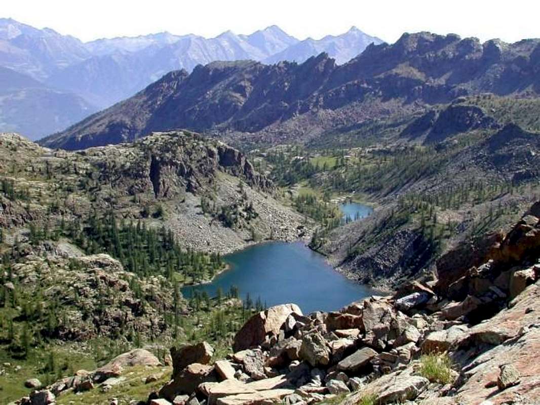
Approach C (From Voella Fraction in Chalamy Vallon, above Champdepraz):
from the Hamlet of La Ville-Veulla through the farm road to the "Magazine" until the junction for Pra Oursì Pasture, at an altitude of 1.340 meters; go in the direction of West passing a first torrent and a second reaching the pasture at an altitude of 1.791 meters (1h'15). From Pra Oursì Pasture definitely changing direction towards the South to reach the path that leads through, first the path that leads from the "Warehouse" and then into the gorge central halls Volla or Vallon of Chalamy. From this junction continue through the path n° 5C/Alpine Via which dates from the same passing neighbor Serva or Selva Loch (1.801m), just below the incumbent walls of Bec l'Espic (2.355m). Past the inlet, the trail continues to the south below a ridge, beyond which, after a bend, reach Alpe Bayet (2.071m); from this point it is mostly in the southeast and crossed the stream that comes down from White Lake, with low down to the Alp Cousse (2.051m). Returning to South Barbustel finally arrive at the refuge, located in a beautiful rocky plateau between White Lake and Lake Vallette and just below the Hills of Lago Bianco and de la Croix Champorcher (EE; 3h'15/3h'30).
Note: be careful which bypasses the area, not to lose the trail that stretches between the Alps Bayet Cousse (especially downhill or in the dark), because you could go too the Northeast in an area of steep rocky plates with rhododendrons. Unpleasant personally experience already made back in 1983 by M. Avic/M. Iverta under the storm.
Avvicinamento C (Dalla Frazione di Voella nel Vallone di Chalamy al Rifugio Barbustel):
Dalla Frazione di La Ville-Veulla, per la strada poderale verso il "Magazzino" sino al bivio per Pra Oursì a quota 1.340 m; salire con direzione Ovest superando un primo torrentello ed un secondo raggiungendo l'alpeggio a quota 1.791 m (1h'15). Da Pra Oursì, cambiando decisamente direzione verso Mezzogiorno, raggiungere, tramite il sentiero di collegamento, dapprima il sentiero che sale dal "Magazzino" e successivamente inoltrarsi nel vallone centrale che sale da Volla o Vallone di Chalamy. Da questo bivio proseguire per mezzo del sentiero n° 5C/Via Alpina che risale il medesimo transitando verso Sudest al Lago della Serva o Selva (1.801 m), al di sotto delle imponenti pareti Nordorientali del Bec l'Espic (2.355 m). Attraversato l'immissario, il sentiero prosegue verso Sud al di sotto di un costolone, oltre il quale, dopo un ansa, raggiunge l'Alpe Bayet (2.071 m); da questo punto si porta maggiormente a Sudest e, attraversato il Torrente che scende dal Lago Bianco, con modesta discesa raggiunge l'Alpe di Cousse (2.051 m). Rientrando a Sud infine arriva al rifugio Barbustel, posto in una splendida spianata rocciosa tra il Lago Bianco ed il Lago Vallette e subito al di sotto dei Colli del Lago Bianco e de la Croix per Champorcher (EE; 3h'15/3h'30).
Nota: fare attenzione, misconoscendo la zona, a non perdere il sentiero nel tratto tra le Alpi Bayet e Cousse (soprattutto in discesa o al buio), perché si rischia d'andar troppo a Nordest in un'area di ripide placche rocciose con rododendri. Personale spiacevole esperieza già fatta nel 1983 tornando dal M. Avic/M. Iverta sotto il temporale.
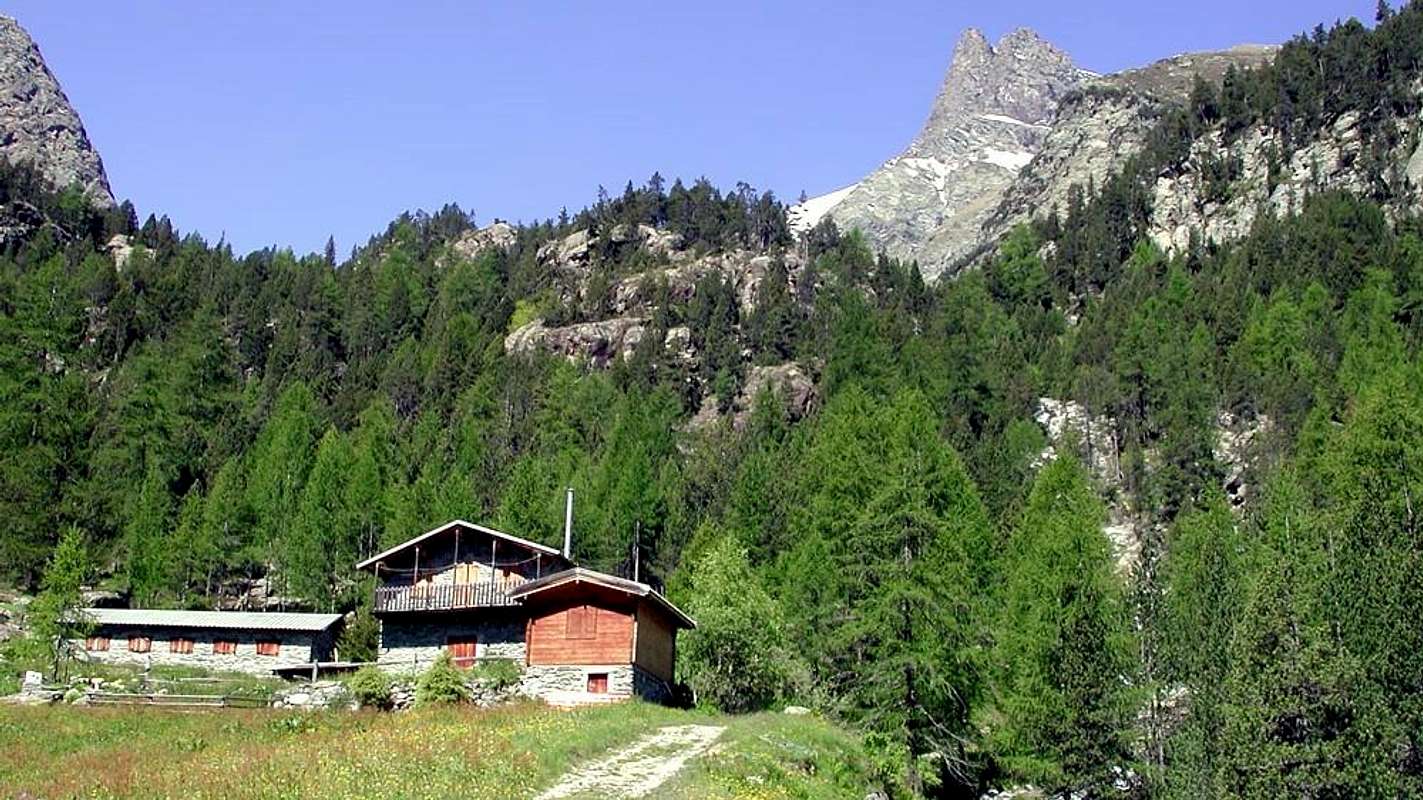
Approach D (from Fénis-Barche through Clavalité Vallon:
From Fénis little town (Barche Village 607m) along the dirt road (no access mark), after Lovignana (1.162m - 9km) that, boarding the Clavalitè Stream ascends the whole valley up to the Baite di Grand Alpe (2.120m), at the beginning of the Comba Tersiva, under the Fénis Pass (2.857m). From the pastures toward East along the path n° 102 up to the Cuneu stabling buildings (2.156m), near the new Bivouac E. Borroz of Clavalité Rotary. Leaving in left (North) the ground road to Etsely Damon (2.434m), in quota (2.156m), near Cuneu's also Cuneux Alp (2.156m), continue, by Southeast direction and path n° 5C,5D up to the an alternative of paths immrdiately after of the La Tramouaille-de-Cuneux or Tramouail, otherwise the more raised Alp and, after the abandon right the path 5D to Moutsaillon Pass, reach the same. With route more in East-southeast through a morainic small vallon to arrive on Fussì Hill; by a short descent of twenty meters reach the previous Approach A from Dondena Village (4h'45/5h'00 from Barche; 3h'30/4h'00 from no thoroughfare near Lovignana Pasture). Otherwise, see Variant below, just longer but with definitely more scenic route through a very ancient route ("Hunters Via").
Variation: from Cuneux or Bivouac of Rotary you can, via the private road towards the North, reaching the Tramouaille-de-L'Echellier or, for the locals, Etsely (2.437m). From this last alp the following path n° 5/102, initially oriented to the East and then South-east leads near the watershed between the Etsely (North) and Fussì Passes; a variant n° 5A reaches this last passing below the dividing crest with Lac Glacier (2.935m) via a diagonal towards the South-southeast over an old mule-track (a quarter hour later).
Avvicinamento D (da Fénis-Barche attraverso il Vallone della Clavalité:
Partendo da Fénis, (località Barche 607 m), percorrere la lunga strada poderale (palina di divieto dopo Lovignana; (1.162 m, dopo 9 Km) che, costeggiando il Torrente Clavalité, risale l'intera omonima valle sino alle Baite di Grand Alpe (2.120 m), all'inizio della Comba Tersiva, sottostante il Colle di Fénis (2.857 m). Dall'Alpeggio seguire verso E il sentiero intervallivo n° 102 fino alle baite superiori del Cuneu o Cuneux od ancora Cuneus (2.156 m), al di sopra delle quali da poco è stato edificato il Bivacco E. Borroz del Rotary Clavalité. Continuare verso Sudest lasciando a sinistra (Nord) la strada poderale per l'Alpeggio Etsely Damon (2.434 m), in quota (2.156 m), presso l'Alpe del Cuneux. Con il sentiero n° 5C,5D e stessa direzione Sudest, continuare fino ad un bivio subito prima di La Tramouaille-de-Cuneux o Tramouail, ovvero l'alpeggio più elevato e, dopo aver lasciato sulla destra il sentiero 5D che si indirizza al Col Moutsaillon, raggiungerla. Con percorso più ad Est-sudest in un valloncello morenico pervenire al col Fussì; una discesina d'una ventina di metri riallaccia al precedente Avvicinamento A (4h'45/5h'00 da Barche; 3h'30/4h'00 dal divieto di Lovignana). Oppure, vedi sotto, con l'antica "Via dei Cacciatori".
Variante: dal Cuneux si può, tramite la poderale verso Settentrione, raggiungere La Tramouaille-de-L'Echellier o, per gli abitanti locali, Etsely (2.437 m). Da quest'ultima alpe il successivo sentiero n° 5/102, orientato dapprima ad Est e poi Sudest, conduce nei pressi dello spartiacque tra i Colli dell'Etsely (Nord) e Fussì; una variante n° 5A raggiunge quest'ultimo passando al di sotto della cresta divisoria e del Lac Glacier (2.935 m), con diagonale verso Sud-sudest su d'una antica mulattiera (circa un quarto d'ora in più).
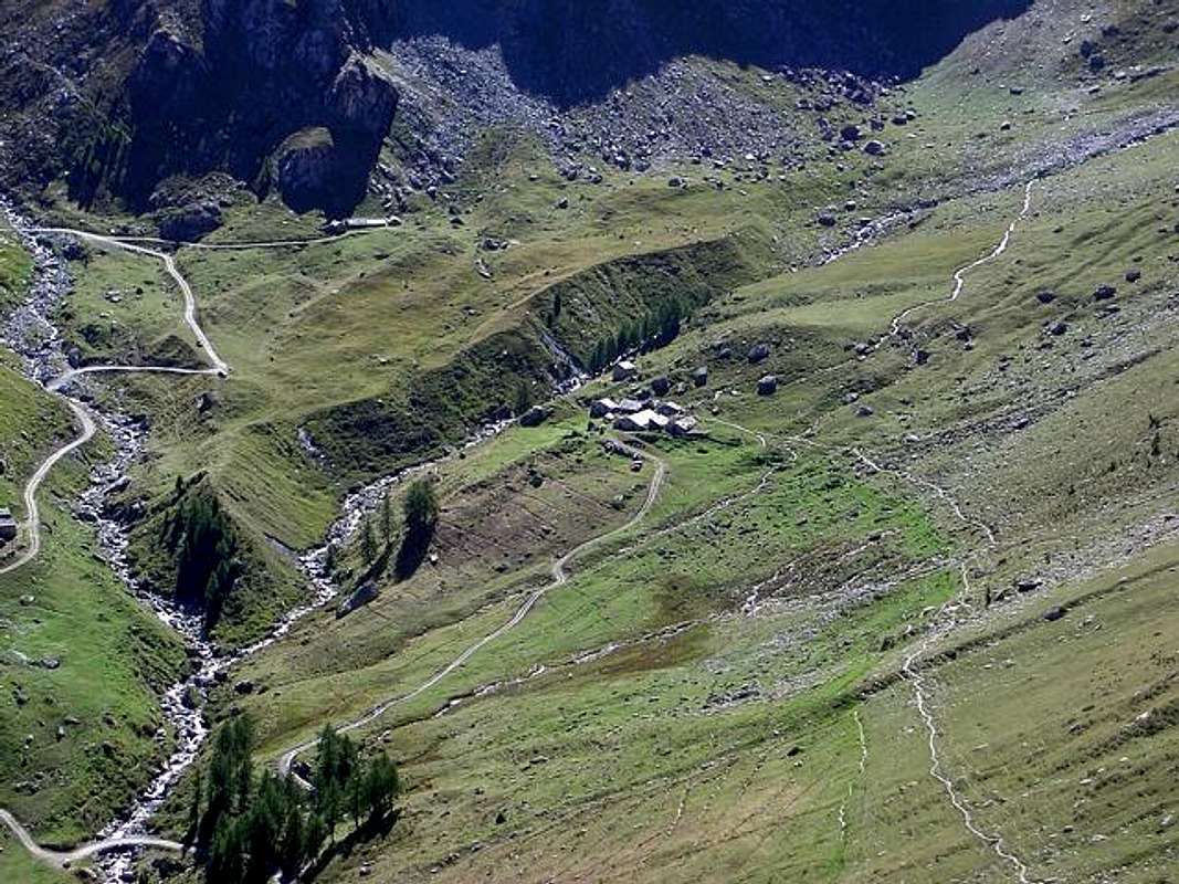
Routes Description
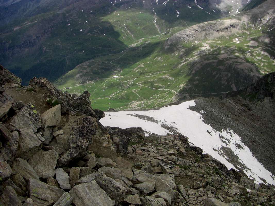
Route A or Standard Route (from Champorcher Valley Dondena Village or from Fénis-Barche through Southwest Slope and South Crest):
Dondena to continue at the moment along the path n° 8B for the Moussaillon Pass (2.853m), leaving the same to the leftt (Northeast) and continue with that (path n° 8C) for the Pass Fussì and nearby Mount Glacier, with a double diagonal between two series of hairpin bends leading to a large saddle around 2.900 meters altitude on a rocky promontory at the base of the Eastern Face of Mont Delà (3.139m). Initially trace for a short time against the walls of this and later, Via a short diagonal down to North, move towards Fussì Pass (2.910m) passing high above Lake Gelato (2.824m) and arriving immediately below the same. From this point the path, with semi circular course under the Southwest Ridge, through an area of large, rotten and broken blocks alternating with stretches of fine debris and then, heading further East, climb a steeper slope, boring and tiring reaching the great Southwest Shoulder (3.003m) immediately on your left (North) of the same; this changing completely the direction towards the North-northwest through the terminal part of South Crest reaches the East Ridge, which rises from the two Hills of the Grande Rossa, in its final part and, through this, with easy rocks addressed West you can easily reach the Summit (EE/F; 3h'15). This path is easy, but in the case of snow, requires attention in the section between the saddle of entry into the vallon, the long crossing to the Col Fussì, that under the South Slope and ascent below the big shoulder (always with considerable avalanches and snowslides danger).
Via A o Normale (dalla Valle di Champorcher-Dondena oppure da Fénis-Barche per il Versante Sudovest e la Cresta Sud):
Dal Villaggio di Dondena proseguire momentaneamente lungo il sentiero n° 8B per il Colle Moussaillon (2.853 m), lasciandolo a sinistra (Nordovest) e proseguire con quello (sentiero n° 8C) per il Col Fussì ed il vicino Mont Glacier, con un doppio diagonale tra due serie di stretti tornanti che conduce ad una larga sella quota 2.900 metri circa su d'un promontorio roccioso alla base della Parete Est del Mont Delà (3.139 m). Dapprima risalire per breve tempo contro le pareti di questo ed in seguito, tramite un corto diagonale in discesa verso Nord, portarsi in direzione del Col Fussì (2.910 m) passando alti sopra il Lago Gelato (2.824 m) ed arrivando immediatamente al di sotto del medesimo. Da questo punto il sentiero, con percorso semi circolare sotto la Cresta Sudovest, attraversa una zona di grandi blocchi alternata a tratti di fine detrito per poi, dirigendosi maggiormente ad Est, risalire un pendio più ripido, noioso e faticoso raggiungendo lo Spallone Sudovest (3.003 m) subito sulla sua sinistra (Nord); da qui cambiando, completamente direzione verso Nord-nordovest, tramite la parte finale della Cresta sud raggiunge la Cresta Est, che sale dal doppio Colle della Gran Rossa, nella sua parte finale e, tramite questa, con facili roccette si giunge facilmente alla Sommità (EE/F; 3h'15). Questa via é facile ma, in caso di neve alta, richiede attenzione nel tratto tra la sella d'ingresso nel vallone, la lunga traversata verso il Col Fussì, quella sotto il Versante Meridionale e nella salita al di sotto dello spallone (notevole pericolo di valanghe e slavine).
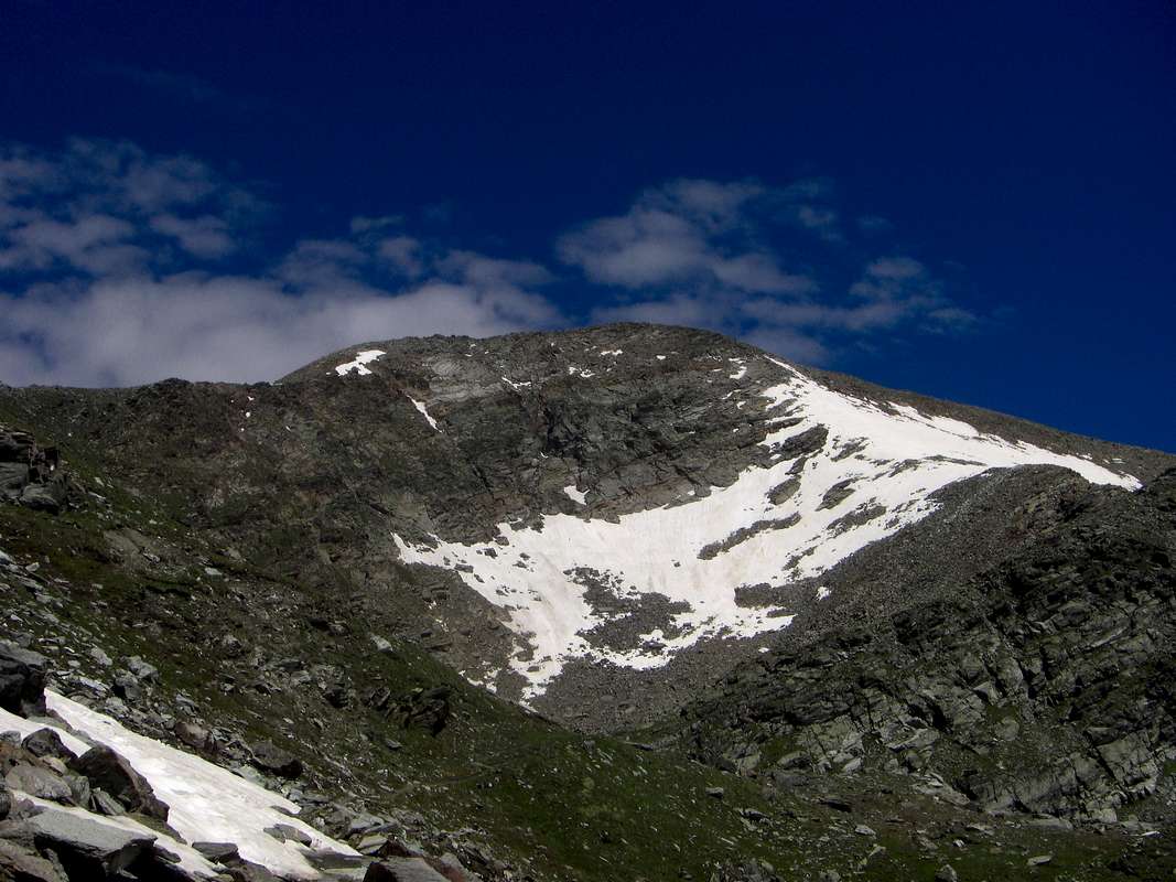
Route B Direst Variant to Standard Route (by Southern Face):
in case of snow in the stretch that goes back to the great Southwestern Shoulder (3.003m), usually at the beginning of the season or after a recent snowfall, you can go directly to the Summit via the South Face abandoning the right (East) track of the Way Normal. When the latter starts the diagonal, after the Fussì Hill, go up a fairly steep snowfield directly to the base of the Southern Slope; bring in the shelter of some plaques gray crossed by a large reddish spot. Circumvented the same just to the right (East), continue on a slope of broken rock, covered with debris and unstable materials, which leads more or less directly to the Top, searching for the path between ledges and small walls. So myself with Gianfranco Vicentini June 20th, 1999 (I°+/II°/II°+, wanting even more) without fixed course (EE/A/F+/PD-; 3h'30/4h'00).
Via B Variante Diretta alla Normale tramite la Faccia Sud:
in caso di neve alta nel tratto che sale alla grande spalla Meridionale (3.003 m), in genere ad inizio di stagione oppure dopo una recente nevicata, si può salire direttamente alla Sommità tramite la Faccia Sud abbandonando a destra (Est) la traccia della Via Normale. Quando questa ultima inizia il diagonale, dopo il Col Fussì, salire su di un nevaio abbastanza ripido direttamente alla base del Versante Meridionale; portarsi a ridosso di alcune placche grigiastra solcate da una grande macchia rossiccia. Aggirata la medesima appena a destra (Est), proseguire su un versante di rocce rotte, coperte da detriti e materiali instabili, che conduce più o meno direttamente alla Sommità, cercando la via tra cenge e muretti. Così il sottoscritto con Gianfranco Vicentini il 20 Giugno 1999 (I°+/II°/II°+, volendo anche di più) senza percorso obbligato (EE/A/F+/PD-; 3h'30/4h'00).
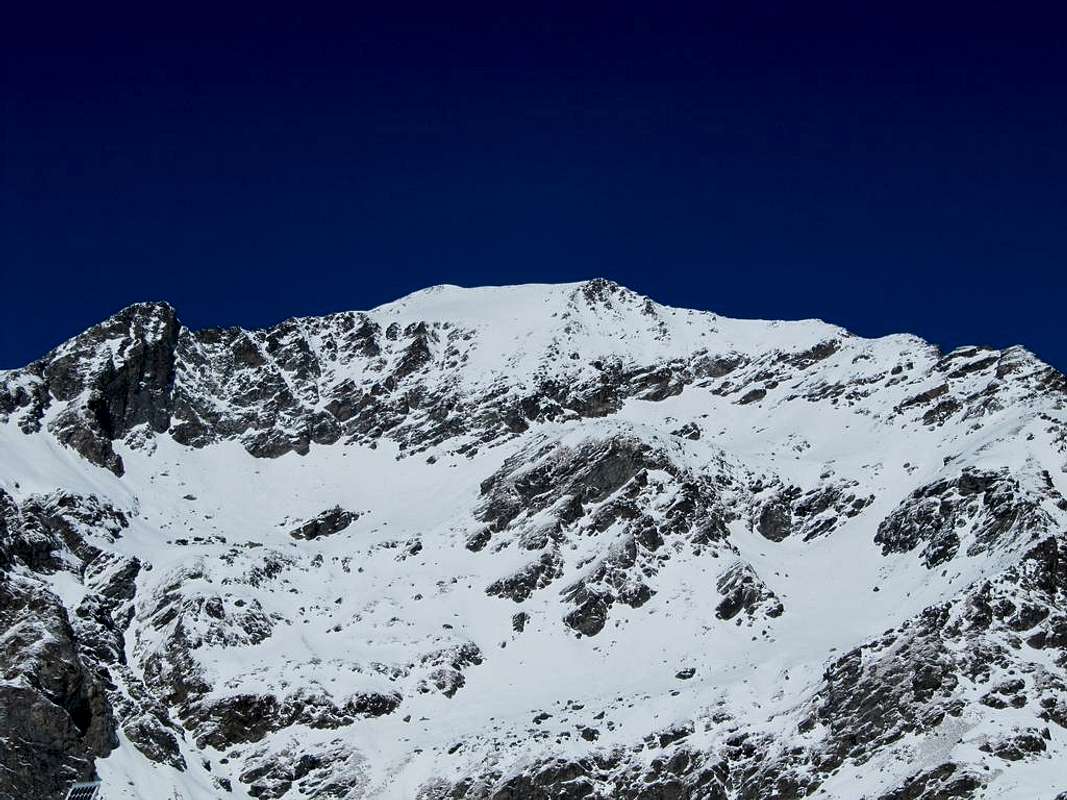
Route C or from Fussì Hill (always Dondena or Barche through Southwest Crest):
reached the Col Fussì from the Vallon of Savoney or the opposite with a small deviation from the normal, start climbing on rocks that are becoming steeper, reaching a small terrace; pass on the left the next gray slab (II°+/III°; in this section requires the rope) still continuing on steep rocks, but they become progressively easier until a first rounded promontory. From this still easily go to the North with progressive lower slope; once on the Western great Shoulder (around 3.080/90 meters), the crest, and farther to the East, it becomes almost "walkable" (2h'00/2h'30 from the hill). This route, gives the Guide B&V as feasible (often these citations do not correspond to a path actually taken place, but rather an analysis from the bottom), has been made down by Roberto Nicco and his companions in the seventies; uphill path to record an ascent certain by the Guide Valpelline Peter Giglio with his son Matteo and another guy, September 11th, 1994. It is not a difficult, but is certainly not aimed at the mass. It requires precautions.
Via C o del Col Fussì (sempre da Dondena o da Barche per la Cresta Sudovest):
raggiunto il Col Fussì dal Vallone di Savoney o dallo opposto con una piccola deviazione dalla Normale, iniziare a salire su rocce che si fanno sempre più ripide raggiungendo un piccolo terrazzo; superare sulla sinistra la successiva placca grigia (II°+/III°; in questo tratto necessaria la corda) continuando ancora su rocce ripide, che però diventano progressivamente più facili fino ad un primo promontorio arrotondato. Da questo proseguire ancora facilmente verso Nord con progressiva minor pendenza; giunti sullo Spallone Occidentale (circa 3.080/90 metri), la cresta, procedendo più verso Est, diventa quasi "camminabile" (2h'00/2h'30 dal colle). Questa via, che la Guida B&V dà come fattibile (spesso queste citazioni non corrispondono ad un percorso realmente avvenuto ma piuttosto da un'analisi dal basso), é stata percorsa in discesa da Roberto Nicco e compagni negli anni settanta; in salita registriamo un percorso certo da parte della Guida di Valpelline Pietro Giglio con il figlio Matteo ed un altro ragazzo, il 11 Settembre 1994. Non é una via difficile, ma non é di certo rivolta alla massa. Richiede precauzioni all'inizio, dove il primo salto roccioso risulta esposto ed assolutamente da non sottovalutare.
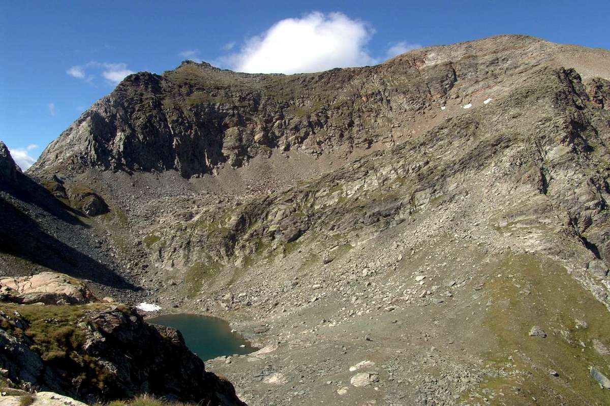
Route D towards Giassit Vallon (always Dondena through the Southern Slopes and Crests or through East-Southeast Face):
of these four "archaic ways" we only give a short-dashed line, as they have meaning only "historic". Probably never again repeated, and rightly so given the poor things they offer in comparison to their hazard. The first route, directed more toward the South, climb the steep slopes of the Southern which are contained in a circular area just above Dondena Hamlet; the same is limited to the West by the spur which descends from the East Ridge near the altitude of around 3.080/90 meters on the great shoulder (3.003m), leaving in bottom West the Lac Glacé and Fussì Hill, while on the opposite side of a buttress parallel down from the Ridge East at an altitude of about 3.015/20 meters, where it is split by sending a branch to the two Gran Rossa Hills. It is able to divide the basin from that of the Giassit Walloon further East. The first or South Crest was once crossed to reach the shoulder joining the Normal Route on the shoulder (3.003m) and with this conclusion. The vast Southern Slope instead was explored October 6th, 1895 by Felice Mondini, Giulio Toesca Castellazzo and Nicola Vigna with a complicated path that bypasses the second of the two ridges and always ends on the East Ridge; the complex descent took off for the Southern Slope. Another route again, made by Mario Aldrovandi with his wife and Gamekeeper Mountain Guide Vassoney Champorcher in 1924, faces the Face East-southeast to the most Northern of the two steep and generally snowy couloirs, to conclude then more equally. For these routes the same considerations and belong to the past; for all, however, there must be the ability to learn to identify the way (from PD/PD to AD, on average; 3h'30/4h'00 Dondena).
For more clarity and so as not to further increase the confusion we give title to the routes starting clockwise from the Northeast to the Southwest:
East Ridge: this is the Eastern watersheed (see below) that goes from the Western Hill of Gran Rossa; has been covered at least once, down by crossing in 1975. There is no news of uphill and is the Eastern Edge of this extremely large slope that ends at the opposite side of the Southwest Ridge above the Col Fussì.
Face East-southeast (couloir right) and Eastern Edge: Walloon Giassit, diverting to the West from the path that leads to the two Hills of the Gran Rossa (PD/PD+/AD-).
Southeast Ridge: Dondena coming directly from the base in altitude around 2.450/500 meters. This ridge, if covered in full (probably Roberto Nicco and Companions seventies) has passages of I°/II°/III° arriving on the Eastern Edge with which to conclude. The same, but starting from the Vallon Giasset, had already been reached by the group in 1895 through a steep gully; from this, with long crossing to the West slopes of the South Face, had reached the opposite Crest South below the great shoulder and concluding with the Normal Route (PD-/PD+/AD-). In the first climb the ridge by Dondena was reached from the West to a grassy couloir that comes to about 2.700 meters.
South Face: the same roped above with "adventurous" descent returning with the ascent up in the middle of the vallon and then directly down "untangling" between small rock walls alternating large and steep rock slabs. Then the slope is only partially path and in the medium-low (PD/PD-/F+/F). The top seems more dangerous that difficult.
Crests South and East: is covered in the last section, the easiest, the Normal. The group rope climbers also traveled in 1895 the middle part, but not completely (PD-/F).
Southwest Side, Ridges South and East or Normal Route Dondena: corresponds to the current Standard Route, in North to the Dondena Village, that passes by La Gelé passing below the Col Fussì then be directed to the great shoulder (3.003m) (F). ( *** all these routes are well identifiable until the Cresta South in pictured below).
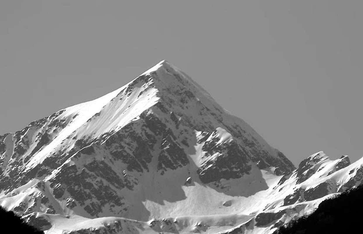
Via D pel Vallone del Giassit (sempre da Dondena tramite i Versanti o le Creste Meridionali eppure tramite la Faccia Est-Sudest):
di queste quattro "arcaiche vie" diamo soltanto un breve tratteggio, poiché hanno esclusivamente in significato "storico". Probabilmente mai più ripetute, giustamente in considerazione delle scarse attrattive che offrono in confronto alla loro pericolosità. Il primo itinerario, rivolto più verso Sud, sale i dirupati pendii Meridionali che sono contenuti in un comprensorio circolare proprio al di sopra di Dondena; lo stesso é limitato ad Ovest dal contrafforte, che scende dalla Cresta Est a quota 3.080/90 metri circa sullo spallone (3.003m) lasciando in basso ad Ovest il Lac Glacé, mentre sul lato opposto un contrafforte parallelo scende dalla Cresta Est a quota 3.015/20 metri circa, dove questa si sdoppia inviando un ramo verso i due Colli della Gran Rossa. Risulta atto a dividere questo bacino da quello del Giassit più ad Est. La prima o Cresta Sud veniva una volta oltrepassata per raggiungere la spalla congiungendosi alla Via Normale sullo spallone e con questa concludere. Il vasto Versante Meridionale invece é stato esplorato il 6 Ottobre 1895 da Felice Mondini, Giulio Toesca di Castellazzo e Nicola Vigna con un percorso complicato che scavalca la seconda delle due creste e termina sempre sulla Cresta Est; la complessa discesa avvenne per il largo Versante Meridionale. Un'altra via ancora, effettuato da Mario Aldrovandi con la moglie e la Guida Guardiacaccia Vassoney di Champorcher nel 1924, affronta la Faccia Est-sudest per il più Settentrionale dei due canaloni innevati, concludendo poi sempre in modo uguale. Per queste vie valgon le stesse considerazioni ed ormai appartengono al passato; per tutte comunque deve sussistere la capacità di saperne individuare la via (da PD-/PD ad AD-; in media 3h'30/4'00 da Dondena).
Per maggior chiarezza ed onde non aumentare ancor di più la confusione diamo titolo alle varie vie partendo in senso orario dal Nordest verso Sudovest:
Cresta Est: trattasi dello spartiacque Orientale (vedi sotto) che sale dal Colle Occidentale della Gran Rossa; é stata percorsa almeno una volta, in discesa con traversata nel 1975. Non si hanno notizie di percorsi in salita e costituisce il margine Est di questo oltremodo largo versante concludentesi all'opposto con la Cresta Sudovest sul Col Fussì.
Faccia Est-sudest (canalone di destra) e Cresta Est: dal Vallone del Giassit, deviando ad Ovest dal sentiero che porta ai due Colli della Gran Rossa (PD/PD+/AD-).
Cresta Sudest: direttamente da Dondena arrivando alla base a quota 2.450/500 metri circa. Questa cresta, se percorsa integralmente (probabilmente Roberto Nicco e Compagni anni settanta) presenta passaggi di I°/II°/III° arrivando sulla Cresta Est con la quale concludere. La stessa, ma partendo dal Vallone del Giasset, era stata già raggiunta dalla comitiva del 1895 tramite un ripido canalone; da questa, con lunga traversata verso Ovest alle pendici del Versante Sud, avevano raggiunto l'opposta Cresta Sud sotto lo spallone e concludendo con la Normale (PD-/PD+/AD-). Nella prima salita la cresta fu raggiunta da Ovest per un canalone erboso che arriva a circa 2.700 metri.
Versante Meridionale: la stessa cordata di cui sopra con "avventurosa" discesa ritornando con la via di salita fino nel mezzo del vallone per poi calare direttamente verso il basso "districandosi" tra muretti roccia alternati a grandi e ripide lastre. Quindi il versante risulta solo parzialmente percorso e nella parte medio-bassa (PD/PD-/F+/F).
Creste Sud ed Est: viene percorsa nell'ultimo tratto, il più facile, dalla Via Normale. La cordata del 1895 la percorse anche nel tratto medio, ma non completamente (PD-/F).
Versante Sudovest, Creste Sud ed Est o Normale: corrisponde all'attuale via, che transita dal Lago Gelato passando al di sotto del Colle Fussì, per poi indirizzarsi allo spallone (3.003 m) sulla Cresta Sud concludendo con quella Est (F). ( *** queste vie sono ben identificabili fino alla Cresta Sud nelle due foto sopra e sottostanti).
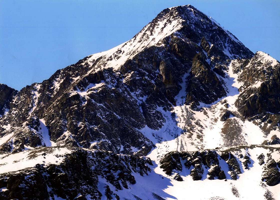
Route E Through the Grand Rossa two Hills (Eastern "Crestone" by Giasset Vallon):
Dondena upper parking continuous toward North reaching the Alp of the Giasset, where it finishes (2.057m); to continue with the path n° 9C more toward Northeast reaching the homonym pond (2.308m; T; 0h'30). From this, taking to the left (North) a slender trace along the frontally floor vallon that is addressed toward the two Hills of the Gran Rossa. From this, taking to the left (North) a slender trace that is addressed on the fund of the before vallone toward the two Necks of the Gran Rossa (SW 2.786m; NE 2.763/66m around), and to reach the loeast to the beginning of the West Crest; from this step over the next two-headed rock or cross the same at the base to the South (even better to reach directly under the Western Hill). From the Hill Southwest, with climbing fairly easy to achieve a first collar consists of bluish rock (2.786m). The next section, more challenging (I°+/II°; outflanked to the North of ledges with soil), leading to the shoulder 3.003 meters, where the ridge is divided by posting a branch in South-east towards the bottom of the Walloon of the Giassit. This sector is made up of large rocky crags that it is better to climb the ridge being formed by rock route and quite friable (also wanting II°+/III -). From the junction continue much more easily to the Summit (F+/PD-; 1h'00/1h'15 from Northeast Hill; 2h'30/3h'00 from Dondena).
Via E dai due Colli della Gran Rossa (sempre dal Giassit tramite il "Crestone" Est):
dal parcheggio superiore con varie segnalazioni appena prima della discesa a Dondena continuare invece sulla destra per breve tratto con la strada in terra battuta che, oltrepassato un secondo più piccolo parcheggio, invita a portarsi verso Nord raggiungendo l'Alpeggio del Giasset, ove termina (2.057 m); proseguire invece con il sentiero n° 9C più verso Nordest raggiungendo l'omonimo laghetto (2.308 m; T; 0h'30). Lasciando a destra (Est) il sentierino per il Colletto Giasset (2.400 m~) che conduce al viciniore Lago del Raty nell'omonimo Vallone, prendere a sinistra (Nord) un'esile traccia, indirizzantesi tra pietraie e campi erbosi sul fondo dell'antistante valloncello alle pendici Orientali del Mont Glacier, verso i due Colli della Gran Rossa (SO 2.786 m; NE 2.763/66 m). Raggiungerne il più basso posito subito all'inizio della Cresta Ovest della Gran Rossa; da questo scavalcare le due teste rocciose successive od attraversar le stesse alla base verso Sud (ancor meglio raggiungere da sotto direttamente il Colle Occidentale). Dal colle Sudovest, con arrampicata abbastanza facile, raggiungere un primo colletto formato da rocce bluastre (2.786 m). Il tratto successivo, leggermente più impegnativo (I°/II°; aggirabile a Nord su cenge con terriccio), conduce alla spalla 3.003 metri, dove la cresta si divide inviando un ramo a Sudest verso la parte inferiore del Vallone del Giassit. Questo settore é formato da notevoli spuntoni rocciosi che é meglio arrampicare sul filo di cresta essendo formati da roccia rotta e piuttosto friabile (volendo anche II°+/III°-). Dalla congiunzione proseguire decisamente in modo più facile fino alla Sommità (F+/PD-; 1h'00/1h'15 dal Colle Nordest; 2h'30/3h'00 dal Villaggio di Dondena).
Route F from two Hills Gran Rossa (reached from Barbustel Shelter through Gran Lago and Oriental "Crestone"):
from the Refuge Barbustel recently built (2.209m), located midway between the Lac Blanc and Lac Vallette (2.132m, 2.170m; 0h'15). From this trace the beautiful and wild Vallon Lake, in the Upper Valley of Champdepraz and, with the trail n° 6/102, pass in succession the White Lake (2.132m), through a short descent, Nero (2.166m) and Cornuto (Horned; 2.168m), passing just above their edges and reaching the Northern Alpage Pisonet (2.301m), located in a beautiful clearing at the end of this first part of the walloon below and a distinctive and overhanging rocky promontory. From this, the same, which gradually turns into beautiful trail, from the West turned decidedly first in the South and then back again to the West the slope with a dozen hairpin bends to stand at Grand Lake (2.485m; 1h'45/2h'00). The same appears to be the most extensive of all the Valley of Aosta and the beginning of the second and higher part of the vallon. Flanking its Northern shore is reached at a waterfall (great place to eat), its tributary and immediately below the Bivouac Verthuy of the Forest (2.535m; private and always closed), amid a cluster of lakes called the Leità (E; 1h'30/2h'00 from Barbustel). From the Great Lake through moraines, immediately after rounding to the right (North) a small rocky promontory above the inlet to reach the three small Lakes Leità (2.564 m); from the top of these continue to the South in a narrow walloon and increasingly steep scree or through snowfields reach with a small dirt track at the end of the Gran Rossa Hill Northeast (2.763/6m), whence the Summit with previous D Route by Eastern Ridge (A/F+/PD-; 1h'00/1h'15 from more Eastern Hill; 4h'00/4h'15 from Barbustel Shelter).
Via F dai due Colli della Gran Rossa (raggiunti dal Rifugio Barbustel tramite il Gran Lago ed il "Crestone" Est):
dal Rifugio Barbustel di recente costruzione (2.209 m), sito a metà strada tra il Lac Blanc ed il Lac Vallette (2.132 m, 2.170 m; 0h'15). Da questo risalire lo splendido e selvaggio Vallone dei Laghi, nell'Alta Valle di Champdepraz e, con il sentiero n° 6/102, oltrepassare in successione i Laghi Bianco (2.132 m), tramite una discesina, Nero (2.166 m) e Cornuto (2.168 m), transitando poco al di sopra dei loro bordi Settentrionali e raggiungendo l'Alpe Pisonet (2.301 m), sita in una bella spianata al termine di questa prima parte del vallone e sottostante ad un caratteristico promontorio roccioso. Da questa il medesimo, che progressivamente si trasforma in bella mulattiera, da Ovest volge decisamente dapprima a Sud e risale quindi nuovamente verso Ovest l'erta con una dozzina di stretti tornanti portandosi al Gran Lago (2.485 m; 1h'45/2h'00). Il medesimo risulta come il più esteso di tutta la Valle d'Aosta ed all'inizio della seconda e più elevata parte del vallone. Fiancheggiando la sua sponda Settentrionale si raggiunge, presso una cascatella (ottimo posto di ristoro), il suo immissario e subito appresso il Bivacco Verthuy della Forestale (2.535 m; privato e chiuso), sito tra un nugolo di laghetti detti della Leità (E; 1h'30/2h'00 dal Barbustel). Dal Gran Lago tramite morene, subito dopo aver doppiato a destra (Nord) un piccolo promontorio roccioso soprastante l'immissario, raggiungere i tre piccoli Laghi Leità (2.564 m); dal superiore tra questi continuare verso Mezzogiorno in uno stretto vallone e per pietraie sempre più ripide o per mezzo di nevai raggiungere con una piccola traccia in terriccio nella parte finale il Colle Nordest della Gran Rossa (2.763/6 m) oppure il Sudovest, donde alla Sommità con la precedente Via D tramite l'abbastanza lunga Cresta Orientale (A/F+/PD-; 1h'00/1h'15 dal Colle più Orientale della Gran Rossa; 2h'00/2h'15 dal Gran Lago; 4h'00/4h'15 dal Rifugio Barbustel).
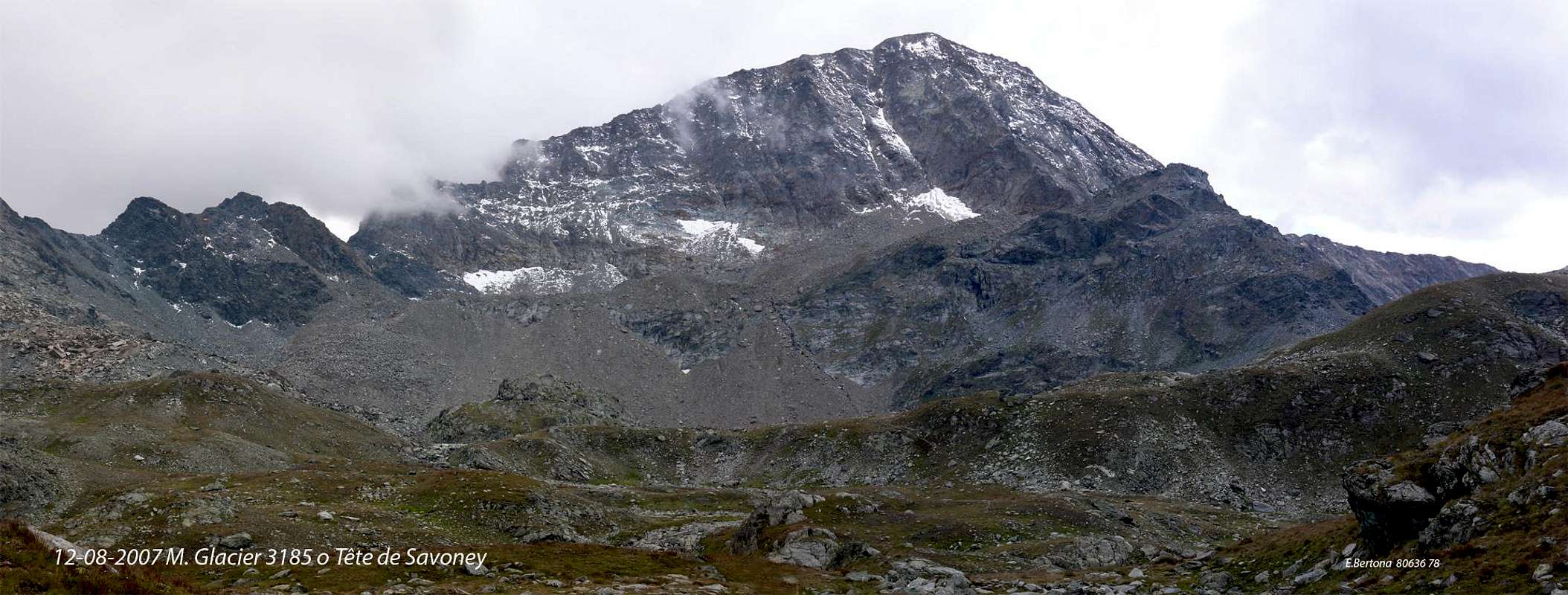
Various Routes G on the North-northeast Face (from the Shelter Barbustel through the Great Lake):
always starting from the Western Side you can climb the Wall East-northeast, leaving to the left (Southeast) the via that leads to the hills of the Gran Rossa or a crossing to the left from near Medzove Pass (2.614m). On this wall there is a history of "old" and the other "modern". In "Guide R.A.V.A" by Mario Aldrovandi, Lattes Turin 1931 Edition and Carlo Fanton Turin 1964, pages 149 and 194, speaking of the eleven gullies Mont Glacier the Author mentions a descent via the Northeast, after rising for the North Slope with his wife accompanied by a Mountain Guide and Gamekeeper Champorcher Vassoney in 1924. it is not given to know the exact route that presumably should take place along the Eastern most of the small couloirs that descend from the Eastern Ridge, just before a triangular rock face. We're not here to "split hairs" in the search for a "Lost Way" leaving the three protagonists of the first path on the same. However, it is only right to point out that a second "exploratory phase" has been taken up by young local climbers with the ascent of the Central Couloir by Pietro Bosonetto and Elio Vittaz in June 1979; the same route has been re-covered the June 8th, 1986 by the three brothers Bastrentaz with Paolo Zappa. But the first had already repeated facing the East Side of the Spur North-northeast, so with a completely off the rock to the right of and below the previous one on the Corner North-northeast in 1915, of which we will discuss below. In any case, all three paths, except the edge, are dangerous for the considerable amount of suspended material, also depending on the condition of snow or ice (from AD to D for the three routes; 2h'00 approximately from the base). Vie however inadvisable that, in any case more "enhance" the descent performed in 1924, also "logical" for faster and therefore less vulnerable to rock falls (see photo Overview).
Varie Vie G sulla Parete Nord-nordest (dal Rifugio Barbustel tramite il Gran Lago):
sempre partendo dalla sponda Occidentale si può salire la Parete Est-nordest, lasciando a sinistra (Sudest) la via che conduce ai colli della Gran Rossa oppure con una traversata verso sinistra dal vicino Col Medzove (2.614 m). Su questa parete esiste una storia "antica" ed un'altra più "moderna". In "Guida della R.A.V.A." di Mario Aldrovandi, Edizione Lattes Torino 1931 ed Ed. C. Fanton Torino 1964, pagine 149 e 194, parlando degli undici canaloni del Mont Glacier l'Autore accenna ad una discesa tramite quello Nordest, dopo essere salito per il Versante Est con la moglie accompagnati dalla Guida e Guardiacaccia di Champorcher Vassoney nel 1924. Non é dato da sapere il preciso itinerario che, presumibilmente, dovrebbe svolgersi lungo il più Orientale tra i piccoli canali che scendono dalla Cresta Est, appena prima di una triangolare parete rocciosa. Non stiamo qui a "sottilizzare" nella ricerca di una "Via Perduta" lasciando ai tre protagonisti dell'epoca del primo percorso sulla medesima. Doveroso é però sottolineare che una seconda "fase esplorativa" é stata ripresa da giovani alpinisti locali con la salita del Canalone centrale da parte di Pietro Bosonetto ed Elio vittaz nel Giugno 1979; la stessa via é stata nuovamente percorsa l'8 di Giugno 1986 da parte dei tre fratelli Bastrentaz con Paolo Zappa. Ma i primi si erano già ripetuti affrontando il lato Orientale dello Sperone Nord-nordest, quindi con una via completamente in roccia a destra della precedente e subito sottostante quella sullo Spigolo Nord-nordest del 1915, de quale tratteremo appresso. In ogni caso tutti e tre i percorsi, tranne lo spigolo, sono pericolosi per la notevole quantità di materiale sospeso, dipendendo inoltre dalla condizione della neve o del ghiaccio (da AD a D per i tre itinerari; 2h'00 circa dalla base). Vie comunque sconsigliabili che, in ogni caso "esaltano" maggiormente la discesa (più logica) effettuata nel 1924.
 |
 |
 |
 |
 |
Route H on the North-northeast Edge (from the Shelter Barbustel through the Great Lake and the Medzove Pass):
from the Great Lake to the Northwest to continue for a short distance to reach the Bivouac of the Forest with trail n° 6/102; allowing the continuation of this North-northwest towards the Plateau of Great Betassa, continuing instead take the path Intervalleys n° 102 to the Southwest, which in the end becomes a track, reaching the Col Medzove or Mezove (2.614m; E; 0h'30 by Grand Lake; 1h'45/2h'00 from Barbustel). Start the climb up some traces reaching a bump in altitude 2.849 meters followed by a collar rock; should always follow the ridge for every 350 meters of the climb, facing a series of rocky plates much broken and covered with debris. Nevertheless, the climbing is enough fun, safe and almost always easy (steps I° and II°) to reach the Summit (PD/PD-; 1h'00 from the base; 3h'00 Barbustel; 4h'30/5h'00 Mont Blanc Champorcher).
Via H sullo Spigolo Nord-nordest (dal Rifugio Barbustel tramite il Gran Lago ed il Colle Medzove):
dal Gran Lago continuare verso Nordovest per breve tratto raggiungendo il Bivacco della Forestale con il sentiero n° 6/102; lasciando la continuazione di questo a Nord-nordovest verso l'altopiano della Gran Betassa, continuare invece a Sudovest con il sentiero Intervallivo n° 102, che nella parte finale diventa una traccia, raggiungendo il Col Medzove o Mezove (2.614 m; 0h'30 dal Gran Lago; 1h'45/2h'00 dal Barbustel). Iniziare la salita su qualche traccia raggiungendo un'asperità in altitudine 2.849 metri seguita da un colletto roccioso; conviene seguire sempre il filo di cresta per tutti i 350 metri circa della salita, affrontando una serie di placche rocciose molto rotte e ricoperte da detriti. Ciononostante la salita risulta abbastanza divertente, sicura e quasi sempre facile (passaggi di I° e II°) fino a raggiungerne la Sommità (PD/PD-; 1h'00 dalla base).
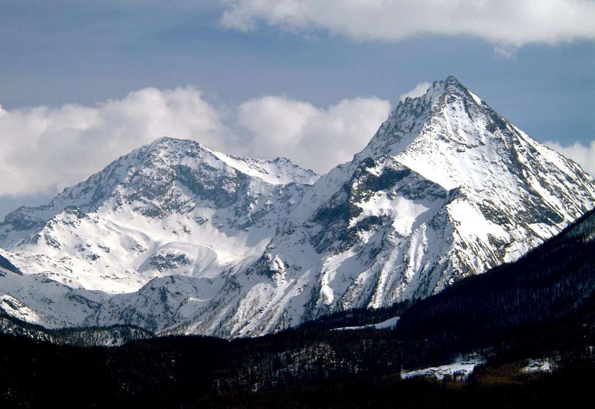
Route I North Wall (from the Vallon of Savoney):
This large wall of trapezoidal shape is perfectly situated between the North-north-east Edge and a long Western Ridge on the watershed that divides Clavalité Walloon from the secondary Savoney, at the top of the head thereof, located between the divide down to the Mont Avic and Mont Rafray with its horrid couloirs. Formed by a large wall behind you as high as you which narrows, is divided in its middle by a rock band that is the "crux", which can be reached via a steep rocky slope that is wedged in the interior thereof. High nearly 600 meters, is formed on its left (West) from a wall of rocks very dangerous and routes that go to "fade" against the edge becoming one with the same, while on the opposite side with a band rocky slopes that reaches the basal rocks. It is uphill once, in its central part, passage of two rock bands rather "irksome" and very exposed to falling rocks, existing over much suspended matter. In this case we have to approach it with connection the way, starting with a deviation that occurs from the Walloon of the Clavalité to Southeast; in fact arrived at a crossroads 1.551 meters immediately after Bioley Damon needs to continue with the path n° 4, concomitant with the private farms dirt road up to the Pastures of Crin and Bayette of Meitin (Middle; 1.642m), where it ends. The trail continues, with the same direction but bending to the South, towards Alp Orgère (1.750m); the final stretch leads, after crossing the Torrent Cavoney, Alp of Savoney (2.129m) and to the next of Mezove (2.390m) at the East foot of Mont Rafray. In a short time you can reach the nearby Lake Margheron or Medzove (2.377m) and continuing for a short distance along path n° 5C to the pass of the same name, will soon leave it and go on devastated rocks towards the miserable remains of a ancient glacier at the base of the face. With rising progressively steeper come to the bottom of it sticking in its midst; directly overcome a series of small rock bands (I°+ /II°-/II°, or circumventing the same more to the West) to reach the "heart" of the face. A gully of scrap (II°+, around 35/40 meters) leads to a terrace debris, sometimes with residues of hard snow; avoiding a rock band more consistent on the left (East), adressed directly towards the Summit through a variety of fairly steep rock slabs with many outstanding and gravels (PD+/AD; 3h'30/4h'00 from base; 4h'30/5h'00 from the junction Bioley Damon; 6h'30/7h'00 Lovignana). Ascension that requires training and experience.
Via I Parete Nord (dal Vallone di Savoney):
Questa larga parete di forma perfettamente trapezoidale é situata tra lo Spigolo Nord-nordest ed una lunga cresta Ovest spartiacque, che divide il Vallone di Clavalité da quello secondario di Savoney, al sommo della testata del medesimo, posto tra lo spartiacque che scende verso il Monte Avic ed il Mont Rafray con i suoi orridi canaloni. Formata da una larga parete alla base che più in alto si retringe, é divisa nella sua metà da una fascia rocciosa che costituisce il "passaggio chiave", alla quale s'arriva tramite un ripido pendio petroso incuneantesi all'interno della stessa. Alta quasi 600 metri, é costituita sulla sua sinistra (Est) da una parete di rocce molto rotte e pericolose che vanno a "smorzarsi" contro lo spigolo diventando un tutt'uno con il medesimo, mentre sul lato opposto digrada con una fascia rocciosa raggiungente le pietraie basali. Risulta salita un'unica volta, nella sua parte centrale, con superamento di due fasce rocciose piuttosto "ostiche" e molto esposte alla caduta di pietre, esistendo al di sopra molto materiale sospeso. In questo caso dobbiamo congiungere l'avvicinamento alla Via, partendo da una deviazione che avviene dal Vallone della Clavalité verso Sudest; giunti infatti al bivio 1.551 metri dopo Bioley Damon devesi proseguire con il sentiero N° 4, concomitante con la strada poderale fino agli alpeggi di Crin e Bayette di Meitin (di Mezzo; 1.642 m), dove la medesima termina. Il sentiero prosegue, con la stessa direzione ma piegando più a Sud, verso l'Alpe d'Orgère (1.750 m); un ultimo tratto conduce, dopo avere attraversato il Torrente de Cavoney, all'Alpe di Savoney (2.129 m) ed a quella successiva di Mezove (2.390 m), alle falde Orientali del Mont Rafray. In breve tempo si raggiunge il vicino Lago Margheron o di Medzove (2.377 m) e, continuando per un corto tratto con il sentiero n° 5C per l'omonimo colle, presto lo si abbandona per dirigersi su scovolte pietraie verso i miseri resti d'un antico ghiacciaio alla base della parete. Con salita progressivamente più ripida, portarsi alla base della medesima attaccando nel suo mezzo; superare direttamente una serie di piccole fasce rocciose (I°+/II°-/II°; oppure aggirandole più verso Ovest) raggiungendo il "cuore" della parete. Un canalino di rottami (II°+, 35/40 metri) conduce ad un terrazzo detritico, a volte con residui di neve dura; evitando tramite una rampa obliqua una fascia rocciosa più consistente sulla sinistra (Est), indirizzarsi direttamente verso la Sommità superando una serie di lastre rocciose abbastanza ripide con molto materiale sospeso e ghiaie (PD+/AD-; 3h'30/4h'00 dalla base; 4h'30/5'00 dal bivio di Bioley Damon; 6h'30/7h'00 dal divieto presso l'Alpe di Lovignana). Ascensione lunga che richiede ottimo grado di allenamento e buona esperienza.
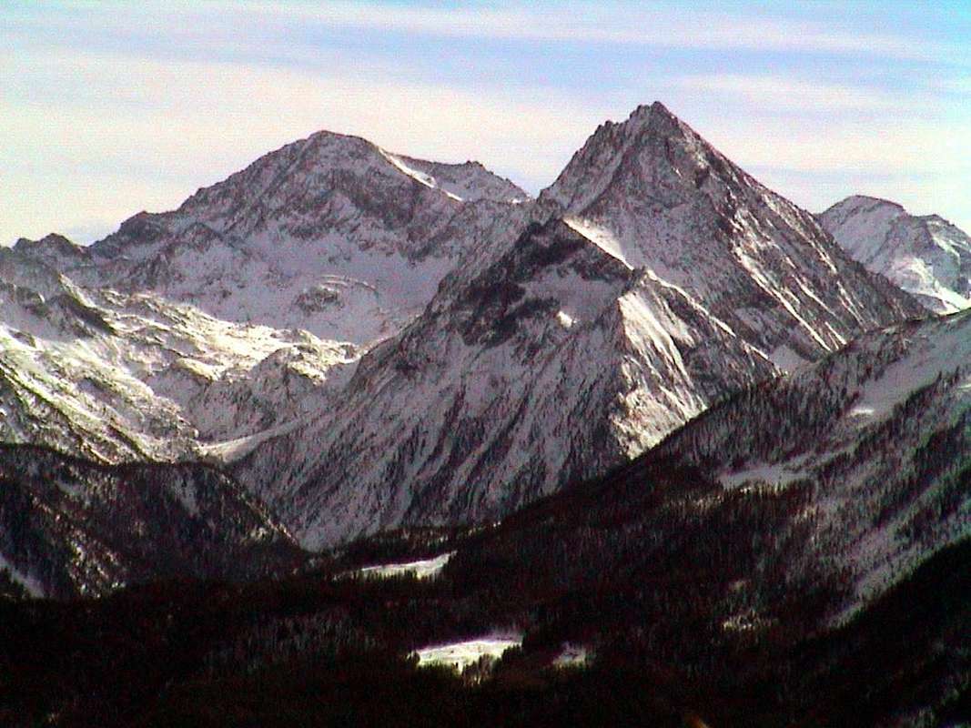
Route L from the Vallon of Savoney (Northwest Ridge):
this ridge "accompanies" the Western Wall on the North reaching the Ante Top Western (about 3.120/30 meters), over a wide turn in toward the North, the Col d'Eyèle or dell'Etsely also even Echelly (2.803 m), near the base of the South Crest of Mont Rafray (3.146m). In the first section after the hill, just below the crest, climbing a trail connecting with the Col Fussì proceeding towards the latter away from the ridge. It is the great divider between the Vallons of Clavalité-High Comba Tersiva and Savoney, "tying" Mont Glacier ( * on site also called Tête de Savoney) Mont Rafray in that little spur that reaches the Bec de Viot and Bec of Ansey or d'Ause (2.325m) of, where is the division between the vallons above. Do not described or even mentioned by any publication, on the other hand is a good ridge downhill useful and necessary to return to the Walloon Savoney, which can avoid the longest uphill ride to the Fussì Pass with its encroachment into the side Champorcher Valley. From the Col d'Eyèle:
( ** Accessible from the West on the trail n° 5/102, starting from fork 2.027 meters, just before Grand Alpe Pastures, will then approach the same name or Etsely Dèsott Pastures (2.097m) and Damon (Upper; 2.434m) and the same. E ; 2h'00 from the junction; 5h'00/5h'30 Lovignana Alpage; also from the opposite side with the same path, which starts from the Alp Mezove (2.390m) at the Lake Margheron in the Valloon of Savoney. E; 1h'15 lake; 4h'30/5h'00 from the cartel ban on driving cars Lovignana) get on the edge of the ridge, at first to the South and then gradually bend to the East, reaching the Western Ante Top (about 3.080/90 meters) and immediately after arriving on Summit, without encountering difficulties (EE; 1h'1571h'30 hill). In the event of snow or high this route is not recommended; preferred the ride through the Fussì Hill, that being exposed to the South, certainly enables better conditions even if a little longer (see the ridge on the left in picture Overview).
Via L dal Vallone di Savoney (Cresta Nordovest):
questa cresta "accompagna" sul lato Occidentale la Parete Nord raggiungendo dalla Ante Cima Ovest (3.120/30 metri circa), tramite un largo giro progressivamente verso Nord, il Col d'Eyèle o Etsely (2.803 m), quasi alla base della Cresta Sud del Mont Rafray. Nel primo tratto dopo il colle, appena sotto la cresta spartiacque, sale una mulattiera di collegamento con il Col Fussì che procede verso quest'ultimo allontanandosi dalla cresta. Costituisce il grande divisorio interno tra i Valloni della Clavalité-Alta Comba Tersiva e Savoney, "legando" il Mont Glacier ( * in loco chiamato anche Tête de Savoney) al Mont Rafray in quel piccolo contrafforte raggiungente il Bec de Viot ed il Bec d'Ansey o d'Ause, dove avviene la divisione tra valloni suddetti. Non descritta e neppur citata da alcuna pubblicazione, é invece buona cresta, utile in discesa ed indispensabile per rientrare nel Savoney, che in salita può evitare il più lungo giro fino al Col Fussì con relativo sconfinamento nel lato Champorcher. Dal Col d'Eyèle:
( ** raggiungibile da Ovest tramite il sentiero n° 5/102 che, partendo dal bivio 2.027 metri appena prima di Grand Alpe, raggiunge in successione gli Alpeggi omonimi o Etsely Dèsott (2.097 metri) e Damon (2.434 metri), nonché lo stesso (E; 2h'00 dal bivio; 5h'00/5h'30 da Lovignana; o dal versante opposto con identico sentiero, che parte dall'Alpe Mezove (2.390 m) presso il Lago Margheron nel Vallone di Savoney E; 1h'15 dal lago; 4h'30/5h'00 dal cartello di divieto di transito per le auto di Lovignana) salire sul filo di cresta, dapprima a Sud per poi progressivamente piegare ad Est, raggiungendo l'Antecima Ovest (circa 3.080/90 metri) e subito dopo arrivando sulla Cima, senza incontrare particolari difficoltà (EE; 1h'1571h'30 dal colle). In caso di neve fresca oppure alta questo itinerario é sconsigliato; da preferire il giro tramite il Col Fussì, che, essendo esposto a Sud, sicuramente consente condizioni migliori anche se più lungo (vedi la cresta sulla sinistra nella prima foto di Overview).

Route M from Etsely Vallon (Face West-northwest or Standard Route from Clavalité):
Via M dal Vallone dell'Etsely (Versante Ovest-nordovest o Via Normale dalla Clavalité):
questo stretto versante, compresso tra la Cresta Nordovest ed un piccolo sperone roccioso che scende dal primo promontorio sulla Cresta Sudovest, può costituire la Via Normale dalla Clavalité. Un piccolo sentiero sale verso Sudest dal Tramouail d'Eyèle o Damon (2.434 m) andando a collegarsi con la mulattiera che proviene dal Col d'Etsely subito sotto la Cresta Nordovest; seguire per breve tratto ma, appena raggiunto lo sperone di cui sopra in altitudine 2.860/70 metri circa, abbandonare il medesimo verso il Col Fussì inserendosi in questo piccolo vallone. Continuare su di una traccia tra le pietraie che porta al Lago Gelato (2.935 m); da questo piegando gradualmente a destra su pendii di sfasciumi raggiungere la Cresta Sudovest presso tre piccole asperità ed, aggirando le medesime oppure scartandole a destra (circa 3.100 metri) e proseguendo più direttamente verso Est, in breve alla Sommità con la Cresta sudovest, qui decisamente rivolta ad Ovest (EE/F+; 1h'15/1h'30 dal Colle d'Eyèle).
Mountain Conditions
- You can get meteo information at the official site of the Regione Valle d'Aosta:
- Valle d'Aosta Meteo
Webcam
- WEBCAM on Aosta Valley:
- Webcam
Books and Maps
BOOKS:- "Guida delle Alpi Occidentali" di Giovanni Bobba e Luigi Vaccarone C.A.I. Sezione di Torino Volume II (parte II), 25 Maggio 1896.
- "Guida dei Monti d'Italia – Emilius Rosa dei Banchi-Parco del Mont Avic" di Giulio Berutto e Lino Fornelli - Club Alpino Italiano/Touring Club Italiano, Marzo 2005.
- "Diari Alpinistici" di Osvaldo Cardellina e Indice Generale accompagnato da Schedario Relazioni Ascensioni 1964-2019 (inediti).
 |
 |
 |
MAPS:
- Ingenia "Parco Naturale del Mont Avic" Carta dei sentieri 1:25.000.
- Enrico Editori Ivrea "Carta turistica del Canavese" 1:100.000
- Enrico Editore Ivrea-Aosta "Gruppo del Gran Paradiso" 1:50.000.
- L'Escursionista editore "Valle di Champorcher Parco Mont Avic" Carta dei Sentieri (11) 1:25.000.
- L'Escursionista "Valle di Cogne" Carta dei Sentieri 1:25.000.
 |
 |
 |
Important Information
- REGIONE AUTONOMA VALLE D'AOSTA the official site.
- FONDAZIONE MONTAGNA SICURA Villa Cameron, località Villard de la Palud n° 1 Courmayeur (AO) Tel: 39 0165 897602 - Fax: 39 0165 897647.
- A.I.NE.VA. (Associazione Interregionale Neve e Valanghe).
Useful Numbers
- Protezione Civile Valdostana località Aeroporto n° 7/A Saint Christophe (Ao) Tel. 0165-238222.
- Bollettino Meteo (weather info) Tel. 0165-44113.
- Unità Operativa di Soccorso Sanitario Tel. 118.