|
|
Route |
|---|---|
|
|
36.43400°N / 117.355°W |
|
|
Overview
This route was shared by user “Rockslide” on the now-defunct Death-valley.net forum, back on April 16, 2007. I have not climbed this route so can't personally vouch for the conditions or difficulty. But going by Rockslide's description, it is a valid option and not technically difficult.
I decided to share it here in the interest of historical preservation. And in the hope someone will try it, post a report, and maybe even provide a GPX track. I've already climbed the Butte twice so trying this route is not a top priority for me!
Note I do not have any way to contact Rockslide and thus posted this without his permission. So if you're interested in this route, I'd recommend copying/downloading everything in case I'm asked to take this down.
Getting There
The starting point is at about 36.3836, -117.3941 along the Lake Hill Road in Death Valley National Park. This is a dirt road north of Highway 190 on the east side of the Panamint Valley. This is the same road that leads toward the starting point for the "standard route" on the Butte, and to the trailhead for hiking to the Panamint Dunes.
The road is usually washboarded with some washouts but passable for vehicles with good clearance. However, conditions can change. In the links section below, you can find some resources for current road conditions.
There are some informal camp sites along the Lake Hill Road. Current regulations require that you drive in at least one mile from the highway before camping. Also, please try to use a previously-disturbed site.
Route Description
Following is an edited copy-and-paste of the route description Rockslide shared. Many of his comments refer to the photos he posted with the report, but unfortunately those photos were not saved. Nor was any of his GPS data. Only his text and map have survived.
======================
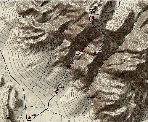
On Friday, April 13 I made it to the top of Panamint Butte, along a route which I've pondered before, and scouted out from several different angles, but had never made a serious effort at actually completing.
There were two obstacles which I wasn't sure I could get past:
> At about 4,500' there is a steep, scary-looking, cliff-forming dark layer, with a similar cliff-forming white layer immediately above. From some angles this combination didn't look too bad; from others it looked impassible to those of us with poorly developed climbing skills and a strong sense of survival.
> There are several faults which cut across the face of the mountain. Not too far from here I was following a similar ridge route and was stopped by such a fault, and the associated 12' cliff face, just about 1/2 mile from my goal.
I'm sure that I'm not the first one to climb the mountain this way, but I couldn't find anywhere where it had been described, so I felt duty-bound to write something myself. For lack of creative inspiration, I've been calling this the "South Ridge" route, to distinguish it from the route which is in the DPS guide (the "North Ridge" route).
I bought a new DeLorme Earthmate PN-20 GPS with my tax refund and this was it's maiden voyage. The waypoints shown were transferred from the EarthMate to Topo USA.
BTW, I'm a left-hander, using a mouse on the right-hand side (one of the few times I conformed to the status quo), so don't expect those lines marking the route to be perfect.
Eventually it's time to get out of the canyon and this is the best spot I found. Sorry about the flare; I tried twice to block out the sun and failed both times.
It's easier to climb than it looks in this picture & you're better off to start up sooner than later (that way you come up right at the saddle).
I made it past the intimidating-looking dark layer of rock & I'm about half way up the intimidating-looking white layer of rock.
Hard evidence that I'm not the first human to walk this ridge...or could this possibly have fallen off the space shuttle?
Getting close...Interesting rock, weathers into natural shingle-like pieces.
Overall, I thought this was a pretty reasonable route to the top. The total distance is about 12 miles and the climb is about 5,050 feet.
======================
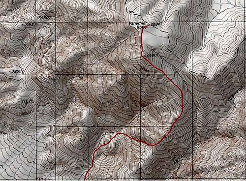
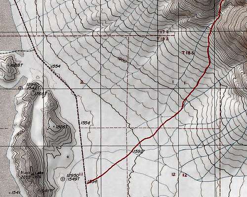
I traced his route using the old TOPO software. That shows the route is about 11 miles round-trip. But I've found that real-world mileage is usually a little more than my hand-traced TOPO tracks. So this route may be closer to 12 miles. TOPO indicates about 5100' of elevation gain. There doesn't appear to be any significant extra elevation gain/loss along the route.
Here is the trace I made on TOPO approximating his hand-drawn route:
Essential Gear
Based on my experience with the "standard route" from the Big Four Mine, trekking poles are recommended.
Miscellaneous Information
When I've been on the summit, or high up on this side of Panamint Butte, I had good AT&T cell service.
External Links
Death Valley NP Backcountry Map: https://www.nps.gov/deva/planyourvisit/upload/508-Backcountry-and-Wilderness-Access-map_.pdf
Death Valley NP Alerts & Conditions: https://www.nps.gov/deva/planyourvisit/conditions.htm
Death Valley NP on Facebook: https://www.facebook.com/DeathValleyNPS
[Death Valley Road Conditions on Facebook: https://www.facebook.com/DeathValleyRoadConditions Apparently no longer updated]


