Start here and park for free!
The purpose of this narrative is to give more details about using the above-mentioned approach to Harney Peak. Interwoven with this narrative are some of the thoughts about and my observations on the trail.
For me, getting to the trailhead was a tad lengthier than climbing into a car and driving. I began in Salt Lake City, UT, on a SkyWest flight to Rapid City Regional Airport, a nice airport about 10 miles southeast of downtown Rapid City. Soon after arriving I was told by locals that many residents refer to their city as “Rapid,” rather than enunciate the entire official name. Fine by me. Rapid it is.
The pilot of the Canadair Regional Jet made a smooth landing and taxied to the waiting jetway; we deplaned ahead of schedule. Down on the ground level my wife and I piled into a Dollar-Rent-A-Car shuttle van for the 15 minute-drive into town, chatting with a couple who had flown in to celebrate the birthday of a family member. Obtaining the compact Kia was a snap and we drove quickly north on Lacrosse Street to an EconoLodge Motel located just north of I-90. We were in our room before one o’clock, and I changed into hiking clothing and set out for the trailhead the conventional way – by car - hoping to be on the trail no later than two o’clock.
The Midwest, including Rapid and the Black Hills, was in the midst of a mild heat wave, and vertical activity in the building cumulus clouds seemed innocuous enough since the more active buildups were near the Nebraska border. I was not expecting to be on the trail very long; the book I referenced for state highpoints indicated that the northern approach via trail #9 was about 3.3 miles, and I knew how quickly I could put that distance behind me.
![Harney Pk via North #9]() Rapid City to Hill City on Highway 16, then to 244
Rapid City to Hill City on Highway 16, then to 244The drive to Hill City on Highway 16 was nearly flawless with a short section of construction and the requisite orange and white-striped cones only slightly impeding my progress. I was surprised at the number of motorcycle riders plying the roads, and then as though to place an exclamation point on my surprise I spotted a Harley Davidson dealership right there in tiny Hill City! It was more than obvious that the town catered to tourists and bikers.
![Harney Pk via North #9]() A closer look at the map never hurts.
A closer look at the map never hurts.At the trailhead and solving a problem
Following instructions from SP I drove south out of Hill City on 16 and, sure enough, about three miles later found the turnoff to Highway 244 not only signed but marked with a full-fledged traffic light. I had seen the silhouette of Harney Peak a couple of times during my drive toward Hill City, but now the closer hills and lodge pole pines obscured my view to the south. It was sad to see the many stands of dead pines, needles a faded red shade, the result of a play in which pine beetles play the role of deadly reapers.
![Harney Pk via North #9]() This kind of sign removes any doubts.
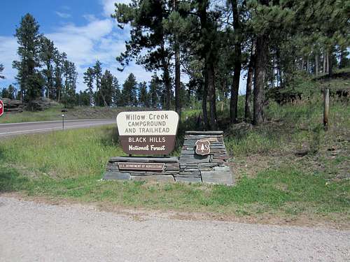
This kind of sign removes any doubts. According to my odometer I had traveled a little over 4 miles on 244 when a large KOA and camping lodge appeared on my left and on my right an easy-to-read sign indicating the Willow Creek Campground and Trailhead. Thirty seconds after turning in I was approaching a large grassy oval area, the parking lot I figured. One RV was positioned at the south end; otherwise there was no sign of life. Beyond this eco-lot there was an extensive corral.
I had made good time en route and was in great position to make my goal of two o’clock for a depart-the-trailhead time. Huh, left Salt Lake City airport at 9:45 and four hours later I was slipping into my Asolo hiking boots and preparing for my first foray into the Black Hills. (Elevation at the trailhead is approximately 5,000’.) With the temperature at 85° I was preparing myself mentally for a bunch of perspiration, silently hoping for some cloud cover to at least temper the extra warmth which glaring sunshine seems to produce. As it would turn out, many areas of the trail were shaded from the forest, so there was some refuge from the sun.
![Harney Pk via North #9]() Informative signboard at the south end of the parking area; the trail literally begins here.
Informative signboard at the south end of the parking area; the trail literally begins here.The signboard at the trailhead was both good and less-than-good. I registered to enter the wilderness and dropped one copy of the permit into the slot of the metal tube standing there at attention next to the container with the permits. There was a fairly detailed map showing hiking trails, Harney Peak, and the park at the south end of the area; that was good. Looking more carefully at the trails left me wondering just a bit; that was not good.
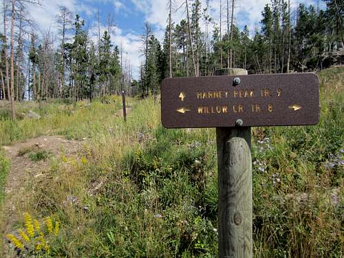
![Harney Pk via North #9]() With no mention of Trail #9 the sign causes confusion.
With no mention of Trail #9 the sign causes confusion.Clearly depicted was trail #8, beginning from where I was supposedly standing. Trail #9 was marked as though it, too, began at this exact point - where I was standing. “Excellent,” I thought. Yet I had taken only fewer than a dozen steps and a sign like this flustered me: ← Willow Creek TR. 8 →. But what about Trail #9? Not good. I went back to the signboard and tried my best to make a reasonable interpretation of this conundrum. According to the map Trail #9 went left while Trail #8 went right. Emboldened with this tiny shred of reasoning I struck out and turned left at the confusing sign, keeping my fingers crossed that this decision did not turn into a nightmare; I didn’t have a lot of extra time and I had no idea what cell phone coverage was like.
On the (correct) trail and feeling good
I began to get worried as I followed the trail and found it snaking mostly to the east with occasional veering to the northeast. Harney Peak was definitely to the south and this path was not heading there. Then I began to hear cars; I looked down and, sure enough, there was Highway 244, big as life. Holy cow, what had I gotten myself into? As if on cue the trail began to angle southward and I figured at the very worst I could just follow this thing back to the car and call it a day if things didn’t improve in a hurry. And they did.
![Harney Pk via North #9]() After 15 minutes of wondering, a sign brings a comforting answer: I'm on the trail I want to be on.
After 15 minutes of wondering, a sign brings a comforting answer: I'm on the trail I want to be on.
After 15 minutes of hiking I came to a sign which brought great relief: a direct reference to trail #9 and also trail #8. I surmised that trail #8 was a loop-trail which overlapped with trail #9 from the trailhead to this point. That would explain the bi-directional arrows back at the beginning which pointed in both directions for #8. Still, it would have been a tad better for the makers of the sign to also allow the engraving of “Trail #9” alongside of the “Trail #8” next to the east-pointing arrow. Well, I was okay, and that was the main thing. Onward and upward. The trail was dry and dusty, rocks here and there, a smattering of deadfall and a meandering direction which was now more southerly than easterly. The slope was gentle.
![Harney Pk via North #9]() After 35 minutes another sign offers helpful information.
After 35 minutes another sign offers helpful information.![Harney Pk via North #9]() Entering a "special area" after 37 minutes of hiking.
Entering a "special area" after 37 minutes of hiking.
After 35 minutes of hiking another sign gave me more information: the mileage back to the trailhead was 1½. "Wow," I thought. At this rate I will definitely be at the summit in just over an hour! Life is good. I had only traveled another 200 yards when I found myself entering the Black Elk Wilderness Area. It reminded me of the wonderful book I had read years earlier titled “Black Elk Speaks.” I recommend it without reservation – no pun intended.
The lodge pole pines were ubiquitous, giant standing armies of rigid watchmen, perhaps there to protect the silent granite rock outcroppings, the size and stature of which continued to increase with elevation. I soon met a group of six young hikers, and they made some acerbic comment about me having a long, long ways to go! Should I write that off as the folly of youth, them expecting everything to be easy? Right here the trail descends about two hundred feet and resumes its upward trajectory after crossing a small stream. As I neared the one-hour point I was already wondering at what point I would suddenly see Harney Peak and its familiar lookout tower. Was that monolith the one? Maybe it’s around the corner or the next bend...
![Harney Pk via North #9]() More and more granite outcroppings, this one after 45 minutes.
More and more granite outcroppings, this one after 45 minutes.![Harney Pk via North #9]() This unusual formation was to the north of the trail at about 47 minutes. Not much wiggle room there!
This unusual formation was to the north of the trail at about 47 minutes. Not much wiggle room there!
Taking a short break at the one-hour point I noted on my GPS that I was only at an elevation of 6,178’ but that I had covered 3.14 miles. Something wasn’t quite right. Let’s see, “The book says 3.3 miles to the summit and yet I still have over 1,000’ to climb in two-tenths of a mile!” No, that couldn’t be right. Something was rotten in Denmark and it had gone sour here in the Black Hills! Still encouraged that I was definitely on the correct route, I dismissed any thoughts of suicide and resumed my hike. Sooner or later this mystery would allow itself to be unraveled.
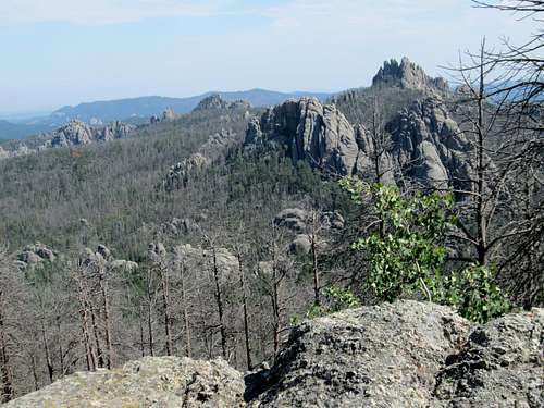
![Harney Pk via North #9]() Shortly after the one-hour point you have your first real look south.
Shortly after the one-hour point you have your first real look south.
Seven minutes later I rounded a shoulder and figured, “Hey, with all of that beauty out there to the south, those giant granite outcroppings like over-sized headstones pointing to the heavens, Harney Peak must be right here somewhere.” Wrong, Mr. Jump-to-conclusions! So I kept hiking, seriously wondering now about the mileage figure of 3.3. At 3:18 p.m., Mountain Daylight Time, the mystery unfolded its inner workings to my wondering eyes: there was Harney Peak, and it looked like it was at least a mile away! And it was waaaay higher than I was. What was going on? Had I somehow gotten off on a side trail, missed the more direct way?
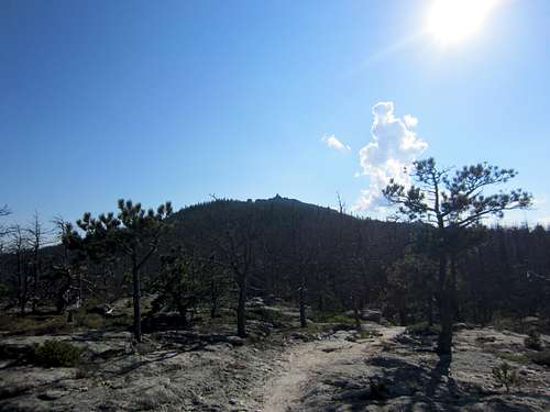
![Harney Pk via North #9]() Hooray - no longer wondering where Harney Peak might be hiding after 1+18
Hooray - no longer wondering where Harney Peak might be hiding after 1+18
Well, the trail was at least heading directly toward the outline of the lookout tower, and this was obviously the highest point around. So I bore down and quickened my pace, remembering that my original estimate for returning to the hotel was now completely out of the realm of reality. I wouldn’t even be back at the car by the time I had said I would be back at the hotel. Reality settling in for an extended stay. But, hey, at last I had the goal in sight.
Yes - the "top" of Harney and end of the trail for today
The trail climbed, a few spots were muddy, and fungi were becoming more abundant along the brushy sides of the trail. At 3:47 after a traverse along a steep hillside to my right I at last encountered a sign for which I had been looking since shortly after two: Harney Peak Lookout! This was a right-angle turn to the west, away from Trail #9. Yup, Trail #9 which went now in both directions from this junction. Go south and head toward Sylvan Lake, go north and find the TH from which I had left nearly two hours earlier.
![Harney Pk via North #9]() At long last, a sign with terrific news: You're almost there!
At long last, a sign with terrific news: You're almost there!![Harney Pk via North #9]() Make a 90 degree right hand turn and feel the excitement!
Make a 90 degree right hand turn and feel the excitement!![Harney Pk via North #9]() Leave the ATV behind and proceed ahead!
Leave the ATV behind and proceed ahead!
I was bounding up this section of trail, leaping over and off boulders, excited to be close to the goal about which I had wondered for many unsettling minutes. I came upon a pair of hikers, a younger man and an older woman, and I passed them quickly after exchanging quick pleasantries. Yes, the woman was struggling. Then a carefully crafted set of flat-rock steps, then steel grated steps. Oh boy, this was it. At 3:54 I was there, the stone lookout tower with two openings to the inner stairs bidding me a silent welcome. A couple was hunkered down in the shade of the tower, enjoying the cool refreshment there.
![Harney Pk via North #9]() Looking south from the platform grate on the "top."
Looking south from the platform grate on the "top."![Harney Pk via North #9]() Gotta have a picture in front of the lookout tower.
Gotta have a picture in front of the lookout tower.
Beautiful views, lots of space and willing photographers for the obligatory summit shots. The young couple left to return to Sylvan Lake and soon the other pair arrived. I found out from them that they were a mother/son combination and that they had taken a trail which was cluttered from beginning to end with deadfall. Therefore their progress had been painstakingly slow, and they were nearly out of both gas and water. Thank goodness I don’t drink much, and I had hardly taken any drinks in my haste to get to the top. I shared with them half of the only liter of water I had, and they were most grateful.
The earlier referenced towering cumulus had petered out without so much as a whimper. Still, more formations were attempting to replace the ones which had died out, and the sun was playing hide-and-seek with them. Cell phone service was strong, so I texted my wife that a major revision was in the works for my ETA back at the EconoLodge. Five o’clock slipped to seven o’clock; but not to worry, I was safe and the reason for the change was the incorrect mileage in the Don Holmes book. My GPS showed the mileage at 5.76. The information on SP cites the mileage via this route at about five. Pretty close for government work.
![Harney Pk via North #9]() Just down from the "viewing platform" a quick glance to the south.
Just down from the "viewing platform" a quick glance to the south.
After spending a quick 13 minutes at the lookout tower I bid the mother and her son adieu and began to hustle down the return route. It was still warm and the occasional breeze was most refreshing. Stopping to take a few pictures of fungi and wildflowers I was back at my blue rental car in 1+42.
![Harney Pk via North #9]() Time on the way out for botanical studies.
Time on the way out for botanical studies.![Harney Pk via North #9]() Appetizers, anyone?
Appetizers, anyone?![Harney Pk via North #9]() Nature's tree huggers.
Nature's tree huggers. It had taken 1+54 to get up, so I didn’t set any records on the descent. But this was one of those trails on which a pell-mell pace downhill could have easily resulted in a turned ankle, so I was content with a more measured tempo. Got back to the trailhead at 5:49 and took Highway 244 back, s-curving close to Mt. Rushmore and getting to see the tiny hamlet of Keystone, in some respects a replica of Hill City: tourist attractions, Borglum museum, zip lines, Rushmore this and Rushmore that and other businesses ripe for cultivating tourist good will in exchange for their dollars.
Back at the hotel just before seven o’clock I was more than satisfied to have made the effort to climb Harney Peak from the Willow Creek trailhead. I can strongly recommend it to others. Just remember, at the trailhead sign which points in both directions for trail #8, go left and you will “run into”trail#9. For what it is worth, my GPS indicated that the total elevation gain including undulations was just over 2,600'.
Comments
No comments posted yet.