|
|
Mountain/Rock |
|---|---|
|
|
52.66900°N / 2.5502°W |
|
|
Shropshire |
|
|
Hiking |
|
|
Spring, Summer, Fall, Winter |
|
|
1335 ft / 407 m |
|
|
The Wrekin Overview:-
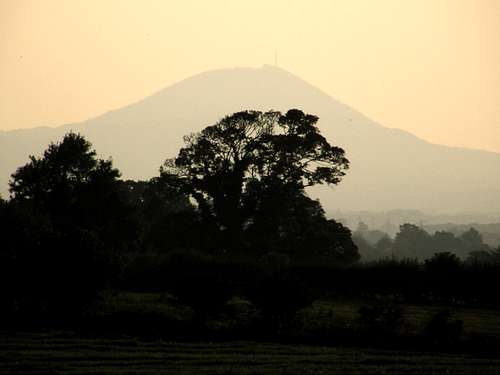
The Wrekin framed with trees from a north east direction with a late evening pink sky
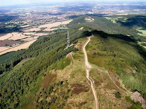
Although only 407 metres The Wrekin dominates the area of mid Shropshire between the towns of Telford and Shrewsbury. In fact the hill overlooks the vast modern town of Telford. The hill is whale back in shape and when seen from the north-west and south-east it is a long gentle looking hill. When seen from the north-east and the south-west it looks like a steep sided conical pyramid that resembles that of a volcano as in the picture above. It does have a history associated with volcanic activity and this is mentioned in more detail further on this page in the section about its geology.
Its status as a Marilyn is a mountain or hill in the British Isles (including Ireland) with a relative height of at least 150 metres (492 ft), regardless of absolute height or other merit. The name was coined as an ironic contrast to the designation Munro , used of a Scottish mountain with a height of more than 3,000 feet, which is homophonous with (Marilyn) Monroe
 |
 |
 |
 |
 |
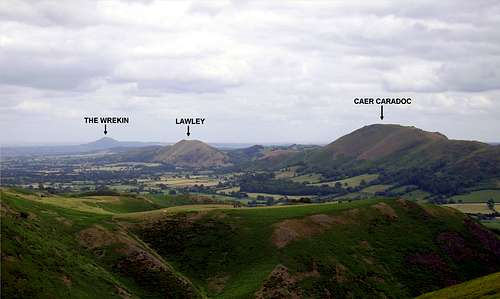
It is not the highest hill in Shropshire but has to be the most well known, many other summits trigs and tops are visible from The Wrekin again for its height in a complete 360degree. More information on the summits visible from up here can be traced in the Panorama image shown below. There are some big 800metre+ summits visible from here funnily all Welsh as far as the Black Mountains and Brecon Beacons in the far south of Wales, Cadair Idris, The Aran's and The Berwyn's in the regions of Snowdonia and North Wales.
To the far north in Lancashire and just north of Manchester is Winter Hill with its 1000feet transmitter mast clearly visible at night due to its aircraft warning lights. Down to the eastern side are the Pennines and Cannock Chase. South east and to the south are the Malvern Hills in Worcestershire along with The Cotswolds through Gloucestershire. Then of course I must not forget the many local hills throughout the South Shropshire Hills designated region of outstanding natural beauty.
The most predominant Shropshire hills are those of Caer Caradoc and Lawley to the south-west. The Clee Hills both Titterstone and Brown to the south along with The Long Mynd and the Stiperstones Ridge to the west. Just in the border of Wales between Shrewsbury and Welshpool a distinctive group of hills called The Breiddens are also visible. The Wrekin is a worthy hill to climb on a clear day as the views you get rewarded from its summit are amazing.
 |
 |
 |
 |
 |
The Wrekin is made of volcanic rock but is not a volcano. It is not-known exactly where the vent that produced this volcanic rock along with the molten rock and ash that was deposited to make up The Wrekin many millions of years ago originated from. There are some amazing rock formations on the southern reaches of the summit. It is, however, very close to the famous Church Sretton Fault, a dormant fault line in the earth's crust. When this fault was active there would have been many volcanic eruptions and earthquakes in the area. This fault line is clearly visible from the summit of The Wrekin when looking in a south west direction. When looking south west the summits of The Lawley and Caer Caradoc are two distinctive hills which are both on this fault line. The fault line showed its presence At 14.50 on 2nd April 1990 when there was a small earthquake in Shropshire due to a slight movement in this fault. Only minor damage was caused but a stone did fall and lodge itself in the Needle's Eye.
The impressive Stretton fault line from The Long Mynd
I remember this earthquake very well as I was at a boarding school just north of Shrewsbury when it happened and out of all the subjects we were studying at the time it was geography…!
The great River Severn when seen from the summit it looks like it runs by the foot of the hill, but actually it is about two miles away at its nearest point.
Ercall Hill (also known as The Ercall):-
Ercall Hill is a much smaller, wooded hill next to the Wrekin with pleasant way-marked paths that can be combined into a days walk with The Wrekin. Sadly It bears the scars of much quarrying so if you go walking there don't stray from the paths as some of the quarry cliffs are very high and can be dangerous.
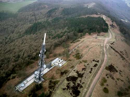
The Summit Transmitter Tower:-
 |
 |
 |
This is a high power TV-Transmitter and covers an extensive area of this region of the West Midlands. The channels and services that are transmitted from this tower are as follows.
| (SITE OWNER) - National Grid Wireless | Analogue TV :- | Digital TV :- | Radio Services :- |
| Site Height at Base: 387m ASL | BBC1: 26 | Mux1: 21/39 | Analogue - BBC Radio Shropshire: 96.0 FM |
| Structure Height / Type: 52m Square Lattice Tower | BBC2: 33 | Mux2: 31/49 | Analogue - Beacon Radio: 103.1 FM |
| UK NGR: SJ 628082 | ITV1: 23 | MuxA: 24/42 | Digital - BBC: 12B |
| More Information Via This Link:- | Ch4: 29 | MuxB: 27/45 | Digital - Digital One: 11D |
| mb21 The Wrekin | Ch5: 35 | MuxC: 53 | Digital - Now Wolverhampton: 11B |
| MB21 The Transmission Gallery | "---------------------" | MuxD: 57 | Digital - MXR West Midlands: 12A |
Getting There:-
A Section of 1:50 000 map from OS map number Landranger 127 - Stafford Telford Area
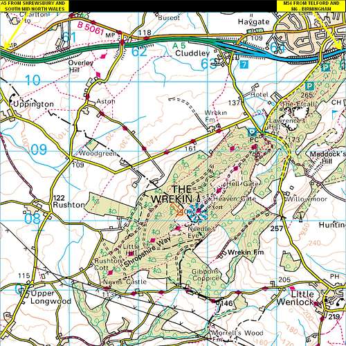
Access to The Wrekin is from the final junction of the M54 Motorway. This is at junction 7 just west of the modern town of Telford and it is at this junction where the M54 becomes the A5 that then heads on to Shrewsbury. When you come off at junction 7 the hill is then signposted. At the bottom there is adequate parking in an area known as Forest Glen and a well defined path / track then leads up and out on to the summit. The track up The Wrekin is the access track for a property part the way up and also for vehicles to access the transmitter tower at the summit a high power main station TV Transmitter that supplies this region of the West Midlands.
From the east the M54 links to the M6 at Birmingham and the M6 from Manchester.
From the west the A5 links through from Shrewsbury and North Wales.
Shrewsbury can also be accessed from all parts of Wales.
The Wrekin is not a difficult place to find at all.
(Streetmap Link Forest Glen) Arrow points at Forest Glen car park the map also shows the last junction J7 of the M54 Motorway.
Red Tape:-
The Wrekin is all part of an area of outstanding natural beauty. Some of the lower levels around it are privately owned land. It is free to rome out on the summit and the woodlands around the countryside within the vacinity of the public footpaths. Where the private land is fenced and normally mark the boundaries just be sensible. More information is available in the council access sections in the external links below.
Safety on the hills and Weather:-
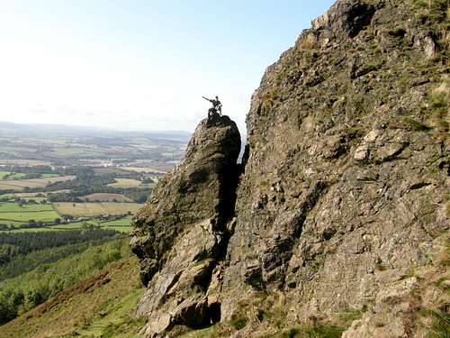
Me sitting on top the Needle of The large mass of volcanic rock on the summit called the Needles Eye
The Wrekin should not give any problems or dangers under weather conditions.
There is a clearly defined track to its summit and the rest of the paths that access the summit are also well defined.
Climbing around on the volcanic rocks of the Needles Eye can be dangerous in wet conditions as the rock is very slippery under foot and the drop off the front of these rocks is enough to seriously injure or even kill yourself if you fell. See picture above of me sitting on the Needle to scale it. Just take it easy.
There is no problem for mobile phone service up here in an emergency as the transmitter tower has every operator and his antennas on it.
The local weather is available via these links by accuweather and BBC.
The Wrekin Weather
The nearest town covered by the BBC 5-Day weather forecast is Telford.
Telford 5-Day weather forecast
The Wrekin in history:-
Iron-Age Hill Fort
Being such a prime spot there is no wonder surmounting the summit of this fine hill is a major hill fort that in total covers around 20acres.
From the Bronze Age to the 1st Century the Wrekin was the hill fort headquarters of the Celtic Cornovii tribe. The last ruler of the hill fort was Virico when the conquering Roman army arrived. The Romans built their fort 4 miles to the west at Wroxeter near Atcham and Shrewsbury but called it Viroconium in honour of their defeated foe. Although no longer a fort the Wrekin became part of a Royal Forest during Saxon and Norman times. The Normans tried to rename the hill Mount Gilbert (after a local hermit), but the name refused to stick and the people all around insisted on still calling it the Wrekin.
A very common local and Shropshire saying is that of "All around The Wrekin"
The Wrekin is also that important that it is used within the local area councils name of "Telford and Wrekin"
Wrekin Stories and Legends:-
There are many stories associated with The Wrekin that have involved giants and devils. There is even a tale of a mermaid in one of the pools. The most well known story has to be the one of the Giant and the Cobbler but this is sometimes told substituting the devil for the giant but the giant version is the older legend and the better one from my point of view.
The Giant and The Cobbler
And so it goes:-A Welsh giant that had planned to block the River Severn and flood the great town of Shrewsbury met up with a cobbler who was returning from his market stall with lots of shoes he had to mend for his customers. When he spoke to the giant he asked him why he was carrying such a large spade full of soil. The giant then said I am going to block the River Severn to flood the town of Shrewsbury. The cobbler thinking quickly said to him. Did you know, Shrewsbury is a long way from here. Look at all these shoes I have worn out just from my return walk. The giant thought hard and said to the cobbler if it is that far I cannot be bothered to carry this spade full of soil any further. Then listening to the cobbler’s advice he dumped the spade full of soil. That is what supposedly made The Wrekin what it is today…!
I like that one.
Another ancient fable tells of two exiled giants that tried to build a new home. They piled up lots of soil to make a massive hill and left a long trench which later filled with water and formed the River Severn. When the hill was finished they argued over who should live there. One giant raised his spade so he could hit his brother, but a raven flew up and pecked him in his eyes so he missed. The spade came down with an almighty bang and left a cleft in the rock on the summit (this feature is now known locally as the Needle's Eye). The raven's attack caused the giant to shed a massive tear which burned into the hill and formed a pool (this pool is now locally known as the Raven's Bowl or the Cuckoo's Cup - no matter how hot the summer, it never dries up).
Whilst arguing the other giant knocked his brother over and piled earth on top of him to imprison him under the soil. This pile of soil is the small neighbouring hill (known as The Ercall) supposedly at dead of night you are still meant to hear the trapped giant moaning.
Local Towns, Tourism, History and Accomodation:-
The large town of Telford is a serious modern town of glass buildings offices and shopping centres. The Great county town of Shrewsbury has lots of history and is a fine place to stay overnight for eating out clubbing and pubs. A lot quieter are the local towns of Wellington and Much Wenlock. Shrewsbury and Much Wenlock are beautiful town's of timber framed black and white streets. A place of serious local history is that of Ironbridge.

The great Ironbridge

Shrewsbury Streets
This is a world heritage site famous for the birthplace of industry and striding over the River Severn in the famous Ironbridge Gorge is the great Ironbridge itself. The only part that mars the view is that of a large coal fired power station with its chimneys and cooling towers spoiling the view when looking up stream.
More information can be found via these links
The Shropshire Tourism website:-
This has many links to other external sites offering further information about Shropshire.
Shropshire Tourism
Shropshire County Council:-
This covers many issues associated with the management of Shropshire.
Shropshire County Council
Telford and Wrekin Council:-
This covers many issues associated with the management of Telford and its area also covering that of The Wrekin.
Telford and Wrekin Council
Shrewsbury Bed and Breakfast's
Telford Bed and Breakfast's
Shropshire Youth Hostel YHA information
Welcome to the Shropshire Hills AONB
This regional area has many other websites that cover it so just type what you wish in a search such as Google and follow through from there.
The Wrekin Seen From The Air:-