
-
 5963 Hits
-
 72.08% Score
-
 2 Votes
|
|
Route |
|---|---|
|
|
39.38580°N / 106.0146°W |
|
|
Hiking |
|
|
Spring, Summer, Fall, Winter |
|
|
Most of a day |
|
|
Walk Up |
|
|
Overview/ Trailhead
This route is the traditional way to climb Hoosier Ridge and its sub-peaks together. It is also the standard winter approach for routes on Hoosier Ridge. The route begins at Hoosier Pass, an 11,539' pass over the Continental Divide located about 11 miles south of Breckenridge and 5 miles north of Alma along Colorado State Route 9. Parking is located on the West side of the pass and the road is maintained in winter, though it can be treacherous driving in heavy snow (8% grade in places with switchbacks)Total Mileage: 11 1/4 Round Trip
Total Elevation: appx 3000' Round Trip (including false summits)
Difficulty: Class 2/Walk Up
Time Required: Appx 6-8 hours depending on season and conditioning
Note: This route can also be climbed in reverse from Boreas Pass in warmer months when the pass is open. The winter closure is appx 6 miles from the pass, but there are 10th Mtn Division Huts at the pass and this could make for a really nice winter getaway if one was interested.
Route to Hoosier Ridge
Cross CO 9 and find the gated dirt road that marks the beginning of the route. A little above you will notice the signed trailhead for the Bemrose Ski Circus. Continue through the trees for approximately 1/2 mile to treeline at 11,800'. The last bit below treeline will have some willows that in winter may cause you some postholing. From this point the terrain steepens slightly and you will gain elevation consitently for 1000' to the top of your first false summit, PT 12814. This point is appx 1 2/3 miles from the trailhead. Continue for 1/2 mile along the bumpy ridge to PT 12953, another false summit. At this point the ridge will turn to the north and the remaining false summits may wear on your senses. Continue for another 2/3 mile to PT 13201 where the ridge will flatten for another mile to the final false summit at 13,300'. From here it is less than a half mile to the summit of Hoosier Ridge and you can see the three 13,000' summits of this route.If you chose to only climb Hoosier Ridge, you can turn around at this point. Round trip for this route would be 8 1/2 miles with 2500' of elevation gain.
 |  |  |
Route to the Reds
To continue on to the adjacent named summits, pick your poison and descend off the summit of Hoosier Ridge. I recommend climbing Red Peak (A), the lower unranked summit at 13,215', first. Descend northeast to the 13,100' saddle, bypass yet another false summit, and climb to the summit of Red Peak (A). There is a steep rocky headwall just below the summit with a couple of climbers trails breaking through to allow for easy passage. From here there are great views to your east of the Front Range and of Boreas Pass. Return the way you came, but if snow conditions allow, you can by-pass the summit of Hoosier Ridge on the right (north) side.Descend from this shoulder to the 12,860' saddle between Hoosier Ridge and Red Mountain (C), a ranked 13er. From here you can see the remaining route to the 13,229' summit of Red Mountain (C). This area holds the most snow on this route and in times of high avalanche danger care should be taken. Especially take precaution at about 2/3 of the way up the ridge, where a cornice forms that has to be crossed or bypassed. The slopes directly under here are steep enough to slide under the right conditions. From the summit of Red Mountain (C) you will have an excellent view of the Tenmile Range, and a view back to the trailhead. There are nearly 5 miles to go on the return, with several false summits along the way. The good news is that they get progressively lower in elevation as you go!
Also note that it is possible to skirt the summit of Hoosier Ridge on the right (west) side, but this should only be done if snow conditions allow. This image shows the terrain on the Hoosier Ridge side of this traverse.
 |  |
Essential Gear
Standard hiking gear will suffice in the warmer months. In winter snowshoes or skis will be wanted below treeline but the ridge sees a lot of wind and they aren't usually required later on.Route Map
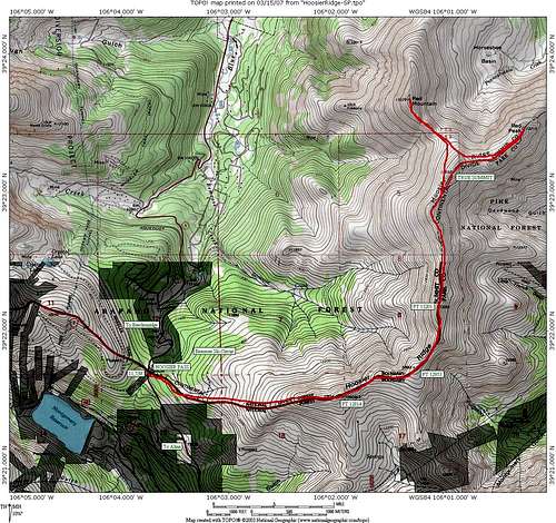
Annotated route overview. Click image to enlarge