
-
 4333 Hits
-
 86.85% Score
-
 23 Votes
|
|
Route |
|---|---|
|
|
46.39050°N / 10.54310°E |
|
|
Mountaineering |
|
|
Summer |
|
|
Most of a day |
|
|
Alpine PD- |
|
|
Overview
Pizzo Tresero Normal route
Pizzo Tresero 3594 m is a high and majestic pyramid peak dominating the village of Santa Caterina Valfurva and it's one of the finest mountain in the Ortles-Cevedale group. It’s the Westernmost summit of the famous Traverse of the 13 peaks; Pizzo Tresero is surrounded by the mighty Forni Glacier and shows four ridges branching from the summit. Along the SW ridge it runs the Normal route starting from Passo Gavia, a frequently climbed itinerary, an easy scramble along the South West ridge, facilitated by the easy access from Passo Gavia and also by the presence of Bivacco Seveso 3398m along the "course".

The Normal route from Passo Gavia is entirely running along the southern flank of the southwest ridge of Pizzo Tresero and it's a beautiful and varied walk up over 3000 meters, then continue along a short glacier until reaching the South-West ridge. An easy climb leads to the summit.
Getting There
The more comfortable access and with less difference in level is from Rifugio Berni located on Passo Gavia and accessible by car from Santa Caterina Valfurva in the omonymous valley (Sondrio province).
The village of Santa Caterina Valfurva m. 1734, situated 12,5 km. to Bormio, is an important destination which can be approached both from Milano following Valtellina and from Alto-Adige through Passo Stelvio. From Santa Caterina take the Passo Gavia road until you reach the Rifugio Berni, near which you will find a church and the war memorial (m. 2541).

|

|
Getting to Santa Caterina Valfurva - From Autobrennero exit Bolzano and follow the road to Merano, then enter Val Venosta and follow it to the fork in Spondigna. Turn to left, following the road to Passo Stelvio (2758 meters, open only in summer time). From here descent to Bormio, then take the road to Santa Caterina (3 hours and half from Bozen, Stelvio pass requires 44 bends to go up and 15 to go down). - From Milano follow the state road "Valsassina" n. 36 to Lecco and then to Colico, here take the "Valtellina" road to Morbegno, Sondrio, Tirano and then to Bormio. In Bormio turn to right taking the Valfurva road.
Route Description

Pizzo Tresero Normal route from Passo Gavia
Difficulty: Alpine PD-
Difference in level: 1050 m. from Passo Gavia m. 2541
Exposure: South-West
Time required: from 6 to 8 hours round trip
The summer standard route starts from rifugio Berni on Passo Gavia and after crossing "Ponte dell'Amicizia" (Bridge of Friendship) follows a short glacier and a last part on the ridge (snow mix rocks). The route is essentialy a walk in its first section; successively it crosses a glacier and follow the South-West ridge with an easy climb. On the summit there is a majestic cross.

|

|

|
From the shelter cross the bridge over the river Gavia. Shortly after the bridge continue on the path without reaching the old Refuge Gavia, take instead the path heading left (signposted "Ponte dell'Amicizia"). After a few minutes, at a crossroads, leave on the left the path that goes slightly downhill to Ponte di Pietra. Continue to the right with light up and downs until you reach the bottom of the Valley of Dosegù, with the rushing river of the same name flowing across. You pass a beautiful suspension bridge named "Ponte dell'Amicizia" through the narrow gorge, at 2520 m.

|

|

|
The path continues to the right following the steep moraine and stony and grassy hollows. Always to the right of Pizzo Tresero SW ridge rocky slope you will reach a notch, then the Bivouac Seveso at 3398 m of altitude. From the bivouac continue along the easy ridge to a small rocky prominence that can be overcome with some brief passages grading II UIAA. Then the ground is softened, and through debris and broken rocks you can easily reach the impressive summit cross.
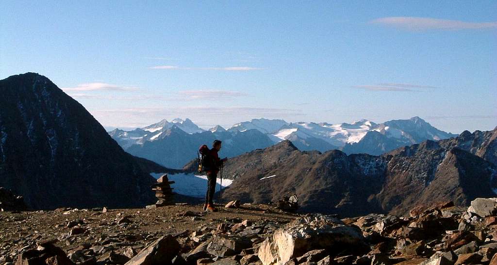
This climb is all on the path in the first half, then over scree debris in the second half and never touches the glacier which is in strong retreat. This route is quite advisable in full or late summer, when the glacier is very dry. In early season you can follow the glacier route. Summit views are wide and spectacular on the western sector of Ortles-Cevedale and the huge Forni Glacier.

|

|
Descent: following the same route - The descent along the ridge rather than the glacier is also advisable when the glacier is in dry condition
Essential Gear
Rope, ice-ax, crampons, high mountain boots and clothes
Red Tape
")
The summit is situated inside Parco Nazionale dello Stelvio, one of the hystorical national parks in Italy, belonging to the provinces of Trento, Bolzano and Sondrio. Free camping is not allowed and fires are forbidden. The whole fauna and flora are protected.
Huts
- Rifugio Berni on Passo Gavia
- Rifugio Bonetta on Passo Gavia
Emergency: Bivacco Seveso on SW ridge
Season
Best period from June to September
Meteo
Guidebooks and maps

"Ortles-Cevedale" by Gino Buscaini - CAI TCI
Maps: - “Ortles-Cevedale” Kompass sheet 72 1:50.000 - "Ortles-Cevedale" Tabacco sheet 08 1:25.000