Comments
No comments posted yet.
|
|
Trip Report |
|---|---|
|
|
Nov 30, 0000 |
|
|
Scrambling |
|
|
Summer |
It was an all day thing. I started with a headlamp and ended with a headlamp. From my parking spot on the side of the Middle St. Vrain Road where my stock Jeep Cherokee couldn't clear a nasty rock obstacle, it was three miles to the trailhead. "Walk from here," I said stoically to myself as I packed my pack and started off. It was 5:45 in early September; later than I should have started for how many miles I had to go, but I hadn't expected to be stopped by rocks on the road. Fifteen minutes later I came across a water hole in the road that appeared to have rocks which, when I stepped on, disappeared and left me in mud halfway up to my knees. Images of an elk that had fallen in a quagmire and starved last year in RMNP flashed through my mind and delivered enough adrenaline to power through two more steps to solid ground. The rest of the 18-20 miles of the day would be with a coating of mud on my Salomon trail running shoes and wool socks. After that, by walking and jogging, I covered the rest of the road to the trailhead in 30 minutes.
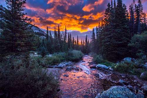
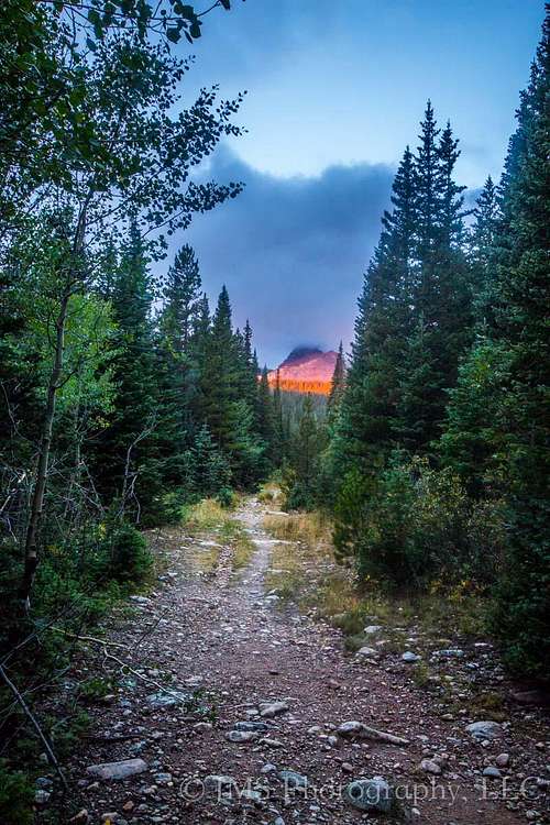
The sun was just rising as I crossed the bridge and entered the wilderness, and its light cast a red spell on Elk Tooth, still six miles away but clearly visible and covered in a cloud As the route description for the Elk Tooth approach says, following the trail was straightforward enough for at least a couple miles. That is, until you come across a mama moose and TWO young ones using the trail to very slowly munch their way up the valley in front of you. After I ran into them the second time, I decided to get off the trail and seek a different route. I struck to the right of the trail where the dew on the grass and vegetation had my shoes and socks completely soaked through in 15 seconds. Two minutes later I emerged upon the talus field, and with thoughts of a mama moose unleashing her fury on me it wasn't long at all before I was high up on the talus, which was pleasantly solid and easy to navigate. From the top of the talus pile, the Elk Tooth summit was once again in view, as was the whole long ridge it was part of. I'm guessing it was at least another couple of miles just straight across the talus before it was time to strike upward to the weakness in the headwall at the top of the ridge. It was already horribly windy, a trend that wouldn't stop the whole rest of the day. The clouds flying overhead, grazing the summit of Elk Tooth, had me quite worried although the weather report had said 15-17% chance of precipitation all day. But by being light on my feet I crossed some serious slog and made it to the Elk Tooth-St. Vrain saddle around 8:30 am.
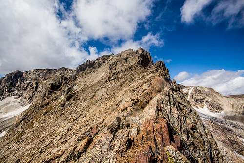
The ridge took on a very intimidating look from here. I began dropping on the right side of the ridge; I really didn't feel like dropping all the way down so I kept trying to hug the wall and getting cliffed out. But I still found a viable route up before getting directly under the summit. I regained the ridge before the summit and transitioned back to the left side, switching side to side as I worked up before summitting at 11:45. I was curious about the register and, pulling it out, found that I was the 12th person to summit the mountain this season. The weather was still doing the exact same thing as it had been all morning - wind blowing scattered clouds a million miles an hour overhead. I took a whole half hour to decide if it was safe to traverse to Ogalalla. It looked amazing from Elk Tooth - rugged cliffs, ravines, and SCRAMBLING!!! The traverse didn't take long; by staying just to the left of the cliff walls on the ridge I pretty easily spotted a ramp up to the final cliff blocking the summit from access. An exposed ledge to the right and then a talus slope as indicated, and an hour and a half later I was quietly sitting satisfied on the Continental Divide where it coincided with the border of Rocky Mountain National Park and the Indian Peaks Wilderness. I was the 18th visitor to this peak for the season.
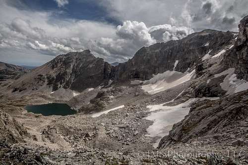
The clouds were still racing and it was incredibly windy though not all that cold. After a peanut butter and jelly sandwich and some dried pineapple I began the trek back. I was not about to re-summit Elk Tooth, though, so I instead began to make my way around the basin to come down to Cony Pass. I started off the summit and was soon quite surprised at the difference in terrain from the side I had ascended. Instead of cliffs, talus, and class 3-5 terrain in general, a smooth, rolling, grassy tundra very gently eased away to the west, north, and south for a long way. I stayed generally close to the edge where it fell away to the basin below. There was one section I had seen from the summit I wasn't sure of, and when I got there I realized any route I could see was at least class 4 down as far as I could see. Given the fact that I was alone and didn't know how far the class 4 extended beyond what I could see, I opted to look for another way down and spotted one along the edge of the ridge toward Isolation Peak. I would be descending to Junco Lake and then reascending to Cony Pass. With a sigh and the impression that that was the only viable option besides going back over Elk Tooth, I began walking around. Not long later I spotted a gully with a cairn at the top of it on the edge. It looked sketchy but it also looked like it would save me from having to walk all the way around and down to Junco Lake, which looked plenty pretty from right where I was. Well I was right on both counts; it did put me out right about at the elevation of Cony Pass but it was probably the sketchiest gully I've ever seen. I don't recommend using it and probably wouldn't ever use it again myself. I thought I was going to die several times from slipping and sliding almost out of control. It probably would have been faster to go all the way around and down to Junco Lake and back up to Cony Pass. But with relief I made it out of the gully and then crossed some more slog over to Cony Pass. With Junco Lake on one side, Cony Lake and the Hutcheson Lakes further below me on the other, and Isolation, Ouzel, Ogalalla, Elk Tooth, St. Vrain, and Copeland all visible around, it was truly an amazing panorama view.
The slog down to Cony Lake was soft and runny and felt nice on my knees. Soon the loose gravel and scree turned to talus and it was a long rock hop down to the lake which had appeared so close but was not in fact close at all. 50 minutes later I crossed the outlet of the lake and began to work up on the scree as I made my way back toward the Elk Tooth-St. Vrain saddle. I made the saddle at 4 pm; that was the last elevation gain of the day. But it would still be 4 hours before I was back at my car, including two more hours of class 2 talus hopping and slogging and then 4 miles of trail and 4x4 road during which something in my left knee turned from a normal end of day ache to a serious sharp pain with every step. After 5 days, a couple Epsom salt baths, and a half dozen ice pack sessions, it's still stiff and hurts like crazy to go down stairs but it's getting better.
But I would do it all over again; it was probably the most epic single day hike I've ever taken. Fourteeners are cool and all but 12ers and 13ers are a different ball game. Isolation, no trails, longer approaches, no step-by-step 14ers.com directions that take all the route-finding out of it - all these things make these shorter monsters that much harder than a Colorado 14er. I have about 20 14ers left to climb to bag them all, but now I have hundreds of 13ers on my list and can't wait to get high again on a new one!