Overview
The estructure of the range:
Los Pirineos \Les Pyrénées (Range)>Area or valley>Massif or Group (if it exists)>Peak
Note to the people that want to write a new peak, a new hut or a new canyon in the range of Pyrenees: you must attach the peak / hut / canyon in the area and as well in the massif or group if it exists but not to this page. If the area doesn't exists you can send me a message to make it in the future or create yourself. As well you can attach the peaks or huts without area in this page and I'll know the area to create in the future but it's not logical to attach all the objects to this page. It's only to a little time. Only the areas must be attached to this page (it's easiest to find the peaks in the same trip or holidays in a zone).
The routes must be attach only to its peaks or areas except the stages of GR-11 or GR-10, the long traverse of full Pyrenees.
The trip reports are welcome if you visit several peaks in different areas. If you have visited only one area it's better to attach the trip only to the area.
The articles about the range are welcome as well in this page.
Images: An image of a new peak, lake, hut, range... is welcome, but please don't add more images of the same peaks or lakes because it's impossible to search a picture among more than 200. I lose a lot of time desattaching duplicate images. The gallery of the areas and peaks is the better place to add a new image (if all the people attach the 10,000 images about Pyrenees to this page the gallery will be impossible to see).
Examples: The peak Marboré is attached to Ordesa-Gavarnie and also in the group (subrange) Cirque de Gavarnie. The peak Aneto is attached to Benasque and also to Maladeta Massif. Maladeta Massif and Cirque de Gavarnie are groups or massifs and they're attached to Benasque and Ordesa-Gavarnie, not to this page. The peak Perdiguero is attached to Benasque but it doesn't appear a group or massif, it's only attached to the area.
In many occasions the peak is frontier between France and Spain and it have routes in both areas, as Perdiguero, La Munia or Robiñera, and they're attached to both areas (the peak always appears in an area in that the route is possible).
Areas of range (the areas without link doesn't exist for the moment in SP). The list is according generally with the editions of the maps most populars in scale 1:50.000:
Spanish side (with name "Pirineos: area"):
-
Bidasoa-Baztan
-
Roncesvalles-Irati
-
Belagua-Hecho
-
Canfranc
-
Tena
-
Ordesa-Gavarnie
---
Cirque de Gavarnie
-
Bielsa
-
Benasque
---
Maladeta Massif
-
Aran-Aiguestortes
-
Pallars-Pica d'Estats in construction
-
Cerdanya / Cerdagne
--
Serra del Cadí
-
Núria-Puigmal
-Tec-L'Albera
-Cap de Creus
Andorra (it's an independent country with only one area).
-
Andorra -
on adoption-
French side (with name "Pyrénées: area"):
-Pays Basque West (Labourd-Basse Navarre)
-Pays Basque East (Barétous-Soule-Basse Navarre)
-
Béarn
---
Vignemale Massif (attached to Ordesa-Gavarnie and Tena as well)
-
Bigorre
-
Luchon
-Couserans
-
Haute Ariége
-
Cerdanya / Cerdagne
-
Canigó -new-
-Roussillon-Côte Vermeille
This map is under construction.... (thanks to visentin for the map)
View Pyrenees in a larger map
Pre-pyrenees (South)
-Prepirineo navarro
-
Prepirineos aragoneses.
-Catalan Prepirineu
Afficher Jacetina sur une carte plus grandeThe name
![Urkulu (1419m)]() Urkulu
Urkulu: The name of this mountain chain comes from the nymph Pirene. According to the legend she died of a sorrow on having seen to go away to Hercules, the Greek semigod of the mythology. When Hercules returned he shouted of anger calling his ear one: Pireneeee! (origin of the name Pirineos or Pyrenees). Some of them say that the mausoleum that he constructed is in the summit of mount Urkulu in Navarra (though more it look like the ruins of a roman tower).
Getting There-The provinces
The Pyrenees constitute the mountainous chain of 440 km that separates France and Spain. The approach of each massif is in the page of the mountains.
Provinces (from west) of the three countrys:
-Spain: Pais Vasco (Guipuzcoa), Navarra, Aragón (Huesca), Cataluña / Catalunya (Lleida, Barcelona, Girona).
-France: Pyrenèes Atlantiques, Hautes Pyrenèes, Haute Garonne, Ariège, Pyrenèes Orientales.
-Andorra: small country without provinces.
The chosen name of the geographical titles to group the massifs in the list is a reference since there is not an "official" classification for group the mountains, but it's the one that follow many books on the mountainous chain. Placing a mountain that is limit between 2 zones in an or another is arbitrary, really it's in both areas even some mountains are difficult assigning to a group.
The election of the representative mountains of each zone is personnel, and I have carried out it for importance and beauty.
Western Pyrenees
![Peñas de Aia between...]() P.Aia
P.Aia![Irubelakaskoa / Alkaxuri]() Irubelakaskoa
Irubelakaskoa
-
Bidasoa:
the first valley from the west is the valley of river Bidasoa with a lot of green hills (except the granitic Peñas de Aia).
![The mount Larrun (900m) is...]() Larrun
Larrun
-
Mountains: Jaizkibel (547m),
Peñas de Aia (837m), Larrun (900m).
-
Baztan-Roncesvalles / Errobi:
the most extensed valley of the Pyrenees of Navarra. The river Baztán it's named Bidasoa in the neighbor valley. Generally the little valleys of Aldudes and Baigorri are included with this valley in books and maps. Roncesvalles has the historic pass across the Pyrenees on Ibañeta (the trail of Santiago, the battle of Roland,...)
![The third stage of GR-11 go...]() Auza
Auza
-
Mountains: Alkurruntz (932m), Gorramendi (1.090m), Mendaur (1.136m), Haltzamendi (818m), Mondarrain (749m), Artzamendi (926m), Irubelakaskoa / Alkaxuri (970m),
Iparla (1.044m), Buztanzelai (1.029m),
Auza (1.306m),
Adi (1.458m), Saioa (1.419m), Adartza (1.250m), Altobizkar (1.506m), Ortzanzurieta (1.567m), Urkulu (1.419m), Errozate (1.345m), Mendizar (1.324m).
-
Irati-Salazar-Roncal / Arbaillies-Zuberoa:
the green sea of forest is named Selva del Irati (Irati's jungle) under the omnipresent Pico de Ory (2018m), the first 2000 meters of Pyrenees.
-
Mountains: Okabe (1.466m),
Behorlegi (1.265m), Escaliers (1.472m),
Ori (2.018m), Abodi (1.520m), Kakueta (1.578m) , Kalveira (1.686m), Idoia (1.749m), Virgen de la Peña (1.294m), Otsogorrigaina (1.922m),
Lakartxela (1.982m),
Lakora (1.877m).
-
Belagua / Lescun:
the first great rocky mountains of Navarra and Bearn.
-
Mountains: Layens (1.625m), Trone de Roi (1.266m), Arlas (2.044m), Billare (2.318m),
Soum Couy (2.315m),
Anie (2.507m),
Añelarra (2.357m), Peneblanque (2.385m), Ukerdi (2.256m), Budogia (2.366m),
Mesa de los Tres Reyes (2.444m),
Petrechema (2.377m),
Acherito (2.378m), Laraille (2.147m), Chinebral de Gamueta (2.329m),
Lapakiza Linzola (2.100m),
Ezkaurre (2.049m).
-
Hecho: the valley of Hecho contain the great mountain of Bisaurin, but as well some interesting two-thousands.
-
Mountains: Gorreta (2.260m),
Anzotiello (2.211m),
Peña Forca (2.391m),
Rincónn de Alano (2.353m), Espelunga (2.106m),
Chipeta Alto (2189m),
Castillo de Acher (2.390m),
Agüerri (2.449m),
Bisaurín (2.670m).
-
Lhers: little valley in french side near of pass of Somport.
-
Mountains: Lariste (2.168m),
Arlet (2.207m), Aillary (2.215m), Labigouer (2.175m), Acué (2.258m).
![Collarada]() Collarada
Collarada
-
Canfranc:
Very wide area with some independent massifs.
-
Mountains:
--Massif of Aspe: Llana del Bozo (2.570m), Llana de la garganta (2.580m),
Aspe (2.645m), Borau (2.561m), Lecherín (2.567m),
Peña Blanca (2.180m).
--Collarada-Ip:
Collarada (2.886m), La Moleta (2576m),
Pala de Ip (2.749m),
Escarra (2.760m), Pala de Alcañiz (2.763m).
--Partacua: Corona de Mallo (2.540m), Peña Parda (2.680m),
Peña Telera (2.765m), Peña Retona (2.718m).
--Formigal-Astun: Arroyeras (2.565m),
Anayet (2.575m), Hourquette (2.384m),
Pic des Moines (2.352m), Astún (2.279m), Anéou (2.364m).
-
Sesques-Iseye-Benou:
secondary massif in french side.
-
Mountains: Gaziès (2.457m), Aule (2.392m), Biscau (2.064m),
Sesques (2.606m), Permayou (2.344m), Ronglet (2.180m), Marère (2.221m), Bergon (2.148m), Iseye (2.173m), Cinq Monts (1.882m), Montagnon (1.973m), Aran (1.796m), Roumendarès (1.646m).
![The Midi d Ossau]() Midi d'Ossau
Midi d'Ossau
-
Ossau
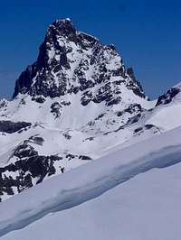
The most amazing peak of Pyrenees, legendary and point of attraction is the Midi d'Ossau.
-
Mountains: Lavigne (2.018m),
Peyreget (2.487m),
Midi d'Ossau (2.885m), Petit Pic (2.807m), Pointe Aragon(2.715m).
Central Pyrenees
-
Lourdes-Gourette
Area of Bigourdan and the area of the great Gabizos and Ger.
-
Mountains: Moullè de Jaout (2050m), Mondragon (1716m), Bazès (1804m), Ger (2613m), Amoulat (2594m), Latte de Bazen (2472m),
Gabizos (2692m).
-
Tena:
very wide area with the first three-thousands and very important mountains.
-Mountains:
-Pallas-Balaitous: Artouste (2816m),
Pallas (2974m),
Arriel (2824m), Soques (2716m), Foratata (2341m),
Lurien (2358m),
Balaitous (3144m),
Frondiella (3071m), Gavizo-Cristal (2890m), Cristayets (2723m).
-Facha-Piedrafita / Estaing-Barbat:
Gran Facha (3005m), Cambales (2965m), Aratille (2900m), Musales (2654m), Llena Cantal (2956m), Piedrafita (2916m), Tebarray (2912m), Gran Barbat (2813m), Midi d'Arrens (2267m), Arrouy (2785m), Peyregnets (2822m).
-Panticosa:
Picos del Infierno (3082m), Arnales (3006m),
Garmo Negro (3051m), Algas (3021m), Argualas (3046m), Batanes (2888m),
Baciás (2760m), Brazato (2734m).
-Tendeñera: Peña Roya (2589m), Sabocos (2757m), Mallo las Peñas (2662m), Tendenera (2853m),
Otal (2709m).
Bigorre-Neouveille
important french massifs in three areas.
-
Mountains:
--Ardiden-Lutour:
Ardiden (2988m), Soum d'Aspé (2968m), Estom-Soubiran (2829m).
--Neouvielle: Campbieil (3173m), Neouvielle (3035m), Pic Long (3192m).
--Bigorre:
Midi de Bigorre (2872m), Soum Arrouy (2488m).
Vignemale:
One of the most important massifs of Pyrenees with great walls and alpine aspect.
-
Mountains:
Grand Vignemale (3298m), Clot de la Hount (3289m), Cerbillona (3247m), Central (3235m), Monferrat (3219m), Tapou (3150m), Petit Vignemale (3032m).
-
Ordesa:
One of the most beautiful valleys and national park.
-
Mountains: Tozal de Mallo (2280m),
Taillón (3144m), Casco (3006m), Marboré (3248m),
Astazús (3071m),
Cilindro (3325m),
Monte Perdido (3355m),
Soum de Ramond (3254m),
Punta de las Olas (3002m).
-
Bielsa:
Zone of transition between the two great valleys of Ordesa and Benasque but with some interesting massifs:
-
Mountains:
--Bachimala: Culfreda (3034m), Lustou (3023m), Abeillé (3030m), Pico de la Pez (3024m),
Bachimala (3177m), Punta Suelza (2973m).
--Cotiella:
Cotiella (2912m), Raimon d'Espouy (2797m), Peña de las Once (2650m), Chía (2517m),
Peña Montañesa(2291m).
--Troumousse:
La Munia (3134m), Troumousse (3085m), Sierra Morena (3090m), Heid (3022m).
-Peyresourde: Mont Né (2147m), Areng (2079m).
-
Benasque:
A lot of three-thousands, the highest point (Aneto), many routes and massifs, snow-glacier, rock,...a great experience for mountaineers.
-
Mountains:
-Maladeta: Salvaguardia (2738m),
Aneto (3404m), Maldito (3350m),
Maladeta (3303m),
Aragüels (3037m),
Ballibierna (3069m), Tempestades (3290m), Russell (3207m), Tuca de Mulleres (3010m), see also
Maladeta Massif
-Posets:
Posets (3375m), Espadas (3332m), Bardamina (3079m), Perramó (2902m), Forqueta de Eriste (3007m), Eriste Central (3053m).
-Gourg Blancs-Perdiguero: Clarabide (3020m),
Gourgs Blancs (3129m), Picos dera Baquo (3110m), Pico de Portillón de Oô (3050m), Spijeoles (3065m), Quayrat (3060m), Lézat (3107m),
Perdiguero (3222m),
Crabioules (3116m), Maupas (3109m), Boum (3306m).
-Sierra Negra-Gallinero: Castanesa (2858m), Ciboll�s (2763m), Gallinero (2728m).
-Turbón: Baciero (2115m), Turbón (2497m).
Eastern Pyrenees
Note: for this page I've divided easily in this way, but generally many people say that Eastern Pyrenees are more in the east (after Andorra) and the highest point is Carlit.
![Aigestortes]() Aguastuertas
Aguastuertas
-
Aguastuertas-Besiberris:
heavenly place with a lot of lakes (called Ibons in the Pyrenees) and the nearby granitic ridge of Besiberris. The image of the Encantats on the great lake of San Maurici is one of the best-known and most spectacular of the Pyrenees.
-
Mountains: Gran Tuc de Colomers (2936m), Punta Alta (3015m), Pic d'Amitges (2851m), Ratera (2862m), Gran Encantats (2745m), Peguera (2983m),
Besiberri (3015m), Comaloforno (3033m).
-
Arán / Couserans-Arège:
little valleys of long access.
-
Mountains: Montardó (2833m), Parros (2727m), Marimanha (2662m), Cabrèra (2630m), Maubèrme (2880m), Malh de Boland (2750m), Barlonguèra (2802m), Mont Valier (2838m), Mont Roig (2868m), Certascan (2853m).
-
Cardòs-Ferrera:
a few of three-thousands, with great ridges and nice valleys. The Pica d'Estats is the highest point of Cataluña and it's a very popular climb.
-
Mountains: Broate (2734m),
Pica d'Estats (3143m), Montcalm (3077m), Sottlo (3072m), Verdaguer (3131m), Canalbona (2960m), Pica Roja (2902m), Baborte (2938m), Monteixo (2904m).
-
Andorra:
little indepent country, with a lot of km of ski-resorts. Very interesting trekking routes with great landscape. Coma Pedrosa is the highest point of this country.
-
Mountains: Coma Pedrosa (2942m), Escobes (2781m), Casamanya (2740m), Estanyó (2915m), Arcalis (2780m), Envalira (2822m).
![Lacs du Carlit]() Lakes of Carlit
Lakes of Carlit
-
Cerdanya-Berguera / Carlit:
interesting valleys, the Cerdanya in Spain and the area of great peak Carlit in France.
Mountains: Puig Pedrós (2911m),
serra del Cadí (2658m),
Pedraforca (2497m), Auriol (2695m), Carlit (2921m).
-
Nuria-Ulldeter / Caret:
Mountains: Puigmal (2910m), Bastiments (2874m), Gallinas (2624m), Rives Blanques (2445m), Tres Esteles (2044m).
-
Canigó:
another very popular mountain of the people of Cataluña, the peak of Canigó, the last great peak and probably one of the widest landscape of range.
-
Mountains: Costabona (2465m), Canigó (2784m), Barbet (2733m), Rojà (2724m).
-
La Jonquera / Roussillon:
easy mountains until the end in the coast of Mediterraneo.
Mountains: Colom (1260m), Tres Termes (1116m), Neulès (1257m), Rodes (760m), Aliga (463m).
The 11 highest points
The 11 highest points or topmost points ("los 11 puntos culminantes"): an interesant project it's the visit of the highest point (vertex) of each one of the 11 main massifs of range of Pyrenees. From west to east this is the list with the grade of the normal (easier) route:
-
Balaitous, 3144m, F+.
-
Grand Vignemale, 3298m, F+.
-
Monte Perdido, 3355m, F.
-
La Munia, 3134m, PD.
-
Pic Long (massif of Neouvielle), 3192m, PD+.
-
Bachimala, 3177m, F.
-
Posets, 3375m, F+.
-
Perdiguero, 3222m, F.
-
Aneto, 3404m, F+.
-
Comaloformo, 3033m, PD.
-
Pica d'Estats, 3143m, F.
GR, the Great Trail
GR="Gran Recorrido" (Great Itinerary or Great Trail).
The great path of red-white painting across all the Pyrenees from west to east (or east to west) in approach 35-45 stages (days) with two options, the GR-10 in France (north) and the GR-11 in Spain (south). Generally the stages in Spanish territory go on the mountain refuges (reservation obligated) and in French territory go across villages.
The option of the full great itinerary is difficult but many people make some stages in different week-ends or years for enjoy of the landscapes. Generally the path doesn't traverse the main peaks, it follow the easier itinerary to connect the stages.
The GR-11 Trail project: other of the reason to make this page is the posibility to write some information about this important route. My friend "eza" and me we'll write the stages in 5 or 6 parts. Our intention is make the full trail with the next index:
-GR11-Trail (I): Cabo Higuer-Zuriza-"The green Mountains".
-GR11-Trail (II): Zuriza-Panticosa-"The Limestone Ranges".
-GR11-Trail (III): Panticosa-Espitau de Vielha-"The Kingdom of Three-thousands".
-GR11-Trail (IV): Vielha-Ref.Baiau-"The Last Giants".
-GR11-Trail (V): Ref. Baiau-cap de Creus-"The Mediterranean Mountains".
I think that we will complete the project someday and probably not in the correct order...be patient with us!
When To Climb
Summer time is the best epoch (june to september) in the majority of summits.
Mountain Conditions
I.N.M.
climaynievepirineos.com
External Links
- RutasNavarra
routes of mountains of Navarra including the stages of GR-11 of Pyrenees (text in spanish)
- FEDME
paths of GR-11 in the official page of Federation of Mountain of Spain (spanish)
- El Mundo de los Pirineos
magazine with special number with the GR11. Interesting map interactive with the stages.
- Official web page of the Bera Town Council
Though actually under construction, this is the place to find tourist data and accomodation details for the end of stage 1
- Lodging in Burguete / Auritz
Spanish language info from the town council of Burguete, offering data on available "casas rurales" (bed&breakfast, though they might refuse to lodge people for more than a single night) and hotels
- Andorra Walks
English information about some hill walking in Andorra
- Climbs and walks in Andorra
Nice page with good photos, Texts in Spanish, Catalan, French and Englis
- Trekking in Andorra from Arinsal
Arinsal is located in the heart of Andorra's trekking paradise: at the foot of the Coma Pedrosa (2'942m) and the Pic de M�d�courbe (2'914m), surrounded by mountain huts (one which is guarded during the summer) and 6 mountain lakes.
- Casas rurales for the stages from Bera to Isaba
Just type the name of the village where the stage ends in "Search by place"... you will get the names and contact details of the local houses (if there are any) offering accomodation
- Hyparion good information and pictures about Pyrenees and the peaks of 3000m
 61588 Hits
 96.63% Score
 61 Votes


Diego Sahagún - Apr 19, 2009 1:30 pm - Hasn't voted
Vías ferratas en el Pirineohttp://www.desnivel.com/newsletter/desnivelaldia/object.php?o=18372
Rafa Bartolome - Aug 24, 2011 12:06 pm - Hasn't voted
Re: Vías ferratas en el Pirineoes interesante lo de las ferratas, de España había hecho 1 y me quedó una sensación agridulce, pero tras una semana en dolomitas la verdad es que me ha enganchao, sobre todo la de la Marmolada, es increible semejante ambiente alpino con glaciar con una ferrata por la cresta, vaya sitio más especial.
Diego Sahagún - Aug 23, 2011 5:25 am - Hasn't voted
Estaciones meteorológicas de Clima y Nieve Pirineos. Datos en tiempo realhttp://www.climaynievepirineos.com/estaciones.htm
Rafa Bartolome - Aug 24, 2011 12:04 pm - Hasn't voted
Re: Estaciones meteorológicas de Clima y Nieve Pirineos. Datos en tiempo realgracias, incorporo el link
Wiktoria Plawska - May 12, 2014 1:25 pm - Hasn't voted
HPRDoes summitpost have any information on the Pyrenean Haute Route?
Rafa Bartolome - May 12, 2014 1:58 pm - Hasn't voted
Re: HPRnot for the moment. I will try to finish some day GR-10 and GR-11, but I don't know when I will do. The HRP is not in my plans, I'm sorry Wiktoria. I think this link is very interesting but the text is in French (only you can choose English for the titles and menus): http://a-pyrenean-story.pagesperso-orange.fr/hrp-eng.htm you can try to traslate with google maybe... because the information is very very good (I know the places and the information is correct). good luck
Wiktoria Plawska - May 14, 2014 9:53 pm - Hasn't voted
Re: HPRThanks for the info, the French shouldn't be too bad I've taken 6 years :)! Maybe I will make a page is I complete it....