
|
|
Route |
|---|---|
|
|
37.14251°N / 118.53053°W |
|
|
Scrambling |
|
|
Half a day |
|
|
Class 3 |
|
|
II |
|
|
Overview

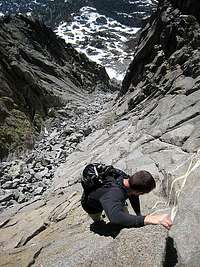
The West Chute of Cloudripper sports relatively straightforward route finding with enjoyable climbing on solid granite and nearby options for spicing up the Class 3 rating. The total mileage with the Green Lake descent is ~8.5 miles with ~4300 ft of gain, making it an easy day excursion from South Lake.
According to Secor (The High Sierra: Peaks, Passes, and Trails, 1999 ed.) the West Chute was climbed by Tony Watkin on June 22, 1997. Given the accessibility of the peak and prominent nature of the gully I strongly suspect the first ascent predates this report.
Getting There

From the South Lake parking area take the Bishop Pass trail 2.9 miles to the signed Bull Lake trail junction (east/left side of trail). Follow the Bull Lake trail around the north end of Chocolate Peak. Leave the trail at the third (east most) Chocolate Lake and skirt the north shoreline to the reach the talus slopes below Cloudripper, aiming for the base of the obvious right-leaning chute, the base of which is bordered by a band of reddish slabs. A blank-looking slab is visible at the top of the route. Approach mileage is ~4 miles.
Route Description
Ascent
From the base of the chute, head up and right and right, aiming for the summit slabs visible from the base. Various options (from Class 3 to low Class 5) exist for ascending the gully and most of the talus/scree is avoidable by staying on the granite blocks/slabs on either side of the gully. After climbing the upper slabs head left to the summit.
Descent
Descend the route, or for variety head north off the summit toward the summit of the unnamed peak to the north. Drop down off the unnamed peak across talus slopes, targeting the west/left side of Green Lake. A trail will be visible on the east slopes above Green Lake heading to the large plateau above the lake; this isn't the direction you want, but it's an easy way to identify the lake.
At Green Lake pick up the trail heading west toward Brown Lake. Take the trail to the junction of the 1.0 mile southwesterly connector that heads back to the parking area or alternatively, leave the trail between Brown and Bluff Lakes and contour around cross-country until you hit the parking area. The dam at the end of South Lake (just north of the parking area) is a good landmark.
Essential Gear
Nothing other than what you would take for a scramble. Optional: mosquito repellent for the swampy areas starting at Green Lake
Topos & Elevation Profile
 |
 |
 |