
|
|
Route |
|---|---|
|
|
39.25380°N / 105.557°W |
|
|
Off Trail Hike |
|
|
Half a day |
|
|
Class 2 |
|
|
Approach
Potato Gulch Trailhead
From the town of Jefferson on US285 to the North, or Lake George on US24 to the South, turn onto Park County 77, also called the Tarryall Road.
Drive South or North to the Tarryall Reservoir. Locate the Northernmost parking area for Tarryall Reservoir on PC77. Drive 0.1 mile North of this parking area and turn onto an unsigned dirt road. This is FS142.
Go 100 yards, and veer right up a small hill.
Above the hill, you will come to a gate that marks the entry onto private property. Cross the gate, making sure to close it behind you. Drive across the private property for 1 mile until you find another gate on the far side. Cross this gate, and ensure you close it behind you. Take care to respect the private property - Don't linger over the one mile stretch.
Past the second gate, FS142 will be signed. Go 0.6 mile to the intersection of FS142 and FS142A. FS142 makes a left turn here. You want to stay straight on FS142.
From the intersection, proceed 1.1 miles on FS142 until it ends at a dead end. As you travel FS142A, there are several secondary roads that branch off of it. If you stay straight, and stay right at the first branch, left at the second, and right at the third, you should be fine. FS142A always appears more traveled than the branching roads, so if you stay on the most traveled road, you should be fine.
Notes on FS142 and FS142A
These roads are both rarely traveled and rough. 4 Wheel Drive is not necessary, but a higher clearance vehicle is. The road gets rougher as you approach the trailhead. A passenger car could make it past the second gate, but maybe not much past there.
The biggest obstacle is a high center between the tire ruts on the road. This gets worse once you pass the intersection of FS142 and FS142A. There aren't many large rocks. The road gets much worse if wet.
Any SUV will be fine. A higher clearance car such as a Subaru Outback might be fine if driven carefully. I never engaged 4WD, like I said, it's a clearance issue.
Route Description
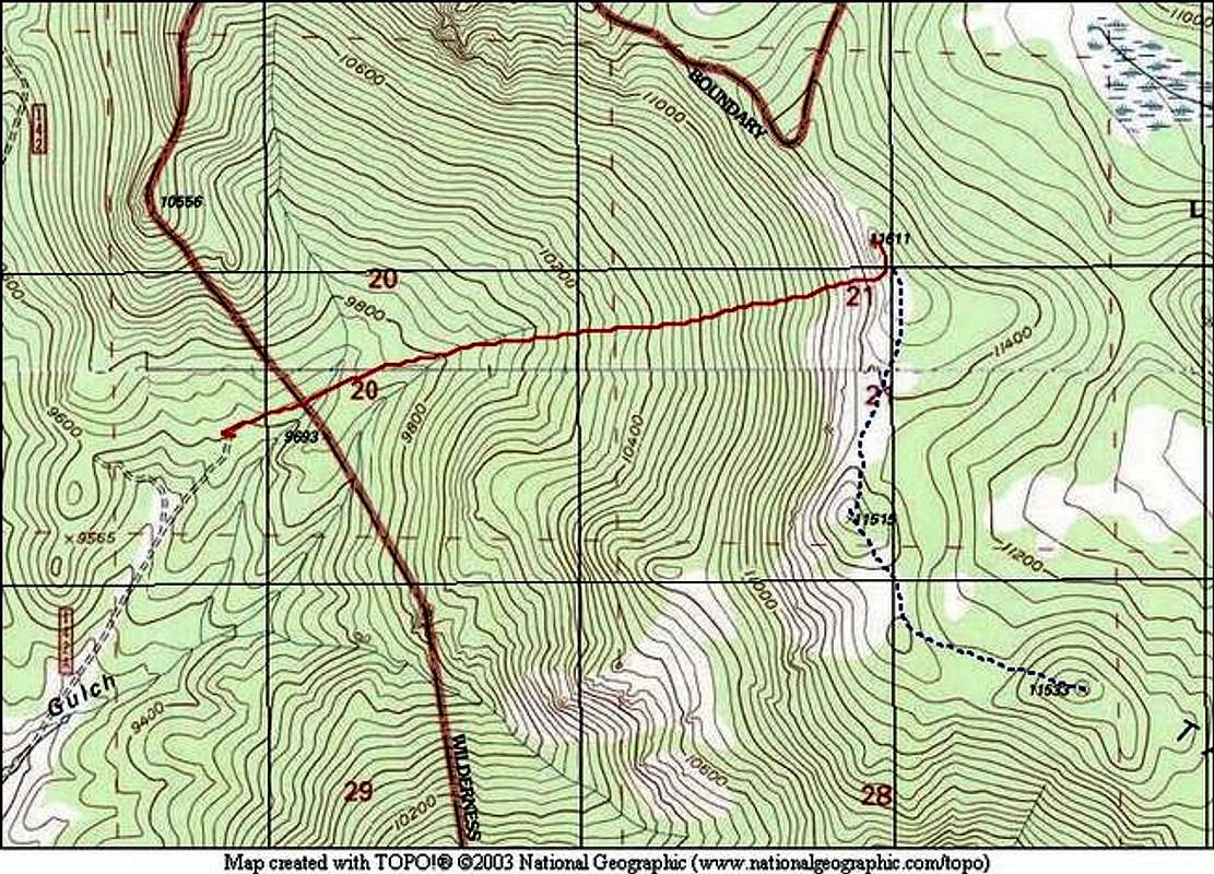
From the dead-end on FS142A, you can see the entire route ahead of you - it's only about a mile and a half away. Ensure that you take some time here to take some mental pictures of the terrain ahead. Once you enter the dense forest, you won't be able to use the large potato shaped rock to navigate. The best way to navigate here is to shoot a bearing from your car, and try to follow it as best you can. The forest can be quite dense, requiring you to traverse back and forth to find the path of least resistance, and this will get you off course very quickly. You might be able to see the top every once in a while, and readjust accordingly. Ensure your navigatinal skills are honed.
Once you enter the forest, you will dip into a creek bed (may be dry). Cross it, and stay on your bearing. If you find another creek bed, follow it until it peters out on the upper slopes - it points almost directly to the summit. If you don't find this creek, rely on your navigational skills. Continue up the steep hill.
If you navigated correctly, you should find yourself in an open area just below the summit ramparts. If not, you'll eventually end up on the ridge Tater Top is on, and you can walk either way to gain the summit. The easiest way to get on top is to circle around the the back side and just walk up. There should be no Class3 and above terrain. If you are stuck with tough scrambing, you are not going the easiest way.
When you are on the summit, you will be able to see your vehicle at the parking area. Shoot another bearing for the walk down. Finding your car on the way down is much harder than finding the ridge on the way up. Take your time and be careful. There are a lot of old roads and trails here. It's easy to get very lost in the dense forest.
Points 11,515 and 11,533
These two unnamed Points are a nice side trip while you're up on top of the Tater Top summit ridge. It will add an extra 1.1 miles to go from Tater Top to the summit of Point 11,533. It is possible to descend from either one of these Points back to the trailhead. See the navigation tips above, and the blue dotted line on the TOPO! below.
The summit areas of these two Points have very interesting rock to explore. There is a flat area between the Points that has interesting dead Pine trees. It's quite a landscape.
Round Trip Mileage: 3.1 miles
Elevation Gain: 2,000 feet

This photo was taken from the parking area, and the route is literally dead ahead to the summit.
Essential Gear
Compass and Map (or GPS). Standard hiking gear will suffice.
Miscellaneous Info
If you have information about this route that doesn't pertain to any of the other sections, please add it here.