
-
 4401 Hits
-
 84.82% Score
-
 19 Votes
|
|
Route |
|---|---|
|
|
47.54565°S / 72.17604°W |
|
|
Mountaineering, Ice Climbing |
|
|
Summer |
|
|
A long day |
|
|
Alpine D |
|
|
Overview
Zorro Colorado - Cerro Dos Picos South Face
The San Lorenzo Group is a wild and charming area located within "Francisco Perito Moreno" National Park, Santa Cruz Province, Northern Patagonia, absolutely fascinating for people wishing to practice an explorative kind of mountaineering. As its name says, Cerro Dos Picos ("Dos Picos" means "Two Peaks") is a bicuspidate secluded mountain belonging to the San Lorenzo Group, located East to Cerro Hermoso. The two summits are separated by a saddle named Paso Hermoso; on the South side of the peak it lies a conspicuous glacier. Due to its shape, Cerro Dos Picos is indicated like "Twin peak" in the report of the first and second summiters, both South Africans. Zorro Colorado is a direct route realized in 1987 on Cerro Dos Picos iced South Face by Davide Brighenti and Alberto Rampini, two members of "Patagonia '87 Italian Expedition", a team who furthermore climbed Cerro Torre and some other new routes in the Cerro Torre group in the same period.

|

|
Getting There
Road access
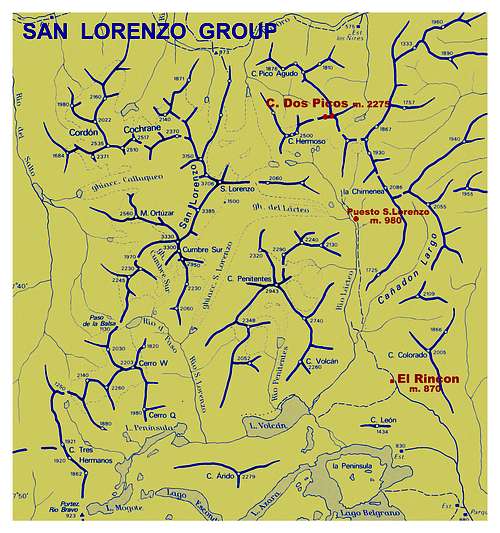
Cerro Dos Picos lies in the Argentinian side of San Lorenzo Group, wilder and less frequented than the Chilean one. Anyway, the approach from Argentina is easy, due to the good tracks coming from Gobernador Gregores to the last "estancias" inside the park. From Gobernador Gregores, a small town lying in Santa Cruz province, Rio Chico department, head towards NW and leave the main Ruta 40 at a fork named "Las Horquetas", where it starts a road heading North-West. Take this road, skirting the magnificent Lago Belgrano and leading to Estancia El Rincon (870 m).

|

|
Walking approach
From Estancia El Rincon the approach is done by means of a two days approach on horseback. From the farm head towards North, entering the Rio Lacteo Valley and reaching Puesto San Lorenzo m. 980, a secluded outpost where you can spend the first night, inside a little wooden cabin. The name "Rio Lacteo", which means "Milky Stream", is probably due to the colour of the water.

|
|
On the second day of the approach trail, about 8 kilometers long, you can enjoy a superb view over the magnificent San Lorenzo East face. At the head of the valley, the track forks. While the left path leads to a lagoon located between San Lorenzo main summit and Cerro Hermoso, the right one reachs a good campsite lying where the forest ends, just in front of Cerro Hermoso and Cerro Dos Picos South sides.
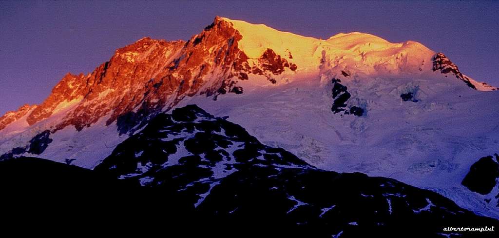
Cerro Hermoso at sundown seen from the BC
Route Description
Zorro Colorado (The Red Fox)
Difficulty: D, 80° max on ice, UIAA IV the rock ridge
Length: 800 m
First ascent: Alberto Rampini C.A.A.I. and Davide Brighenti A.G.A.I.(Patagonia '87 Italian Expedition) 21.11.1987
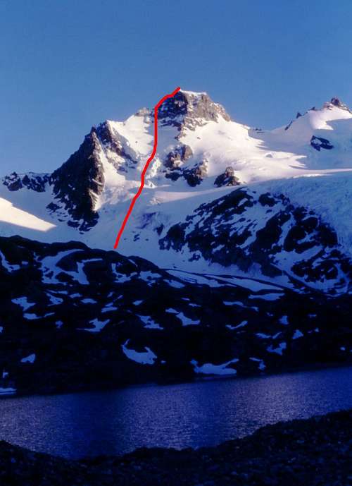
Cerro Dos Picos seen from the Base Camp |
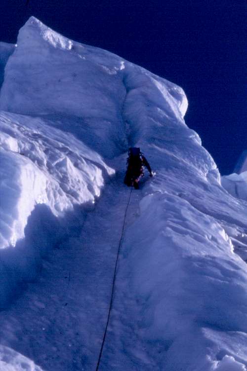
Climbing the seracs-wall |
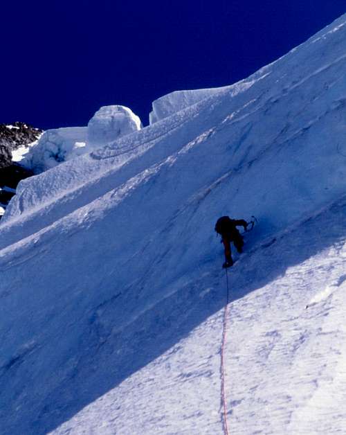
Zorro Colorado central slopes |
Approach from the campsite - From Base Camp South Face is clearly seen and easily approached scrambling up towards the start of the glacier, which is followed towards the high wall of seracs.
Climbing report - Up directly on the steep seracs' wall with several pitches (some pitches till 80°), gaining the upper easier snow slopes, which are followed towards a rocky saddle along the West Ridge. Once getting to the rocky saddle climb the summit rocky ridge (poor rock, max IV grade UIAA), getting to the summit.
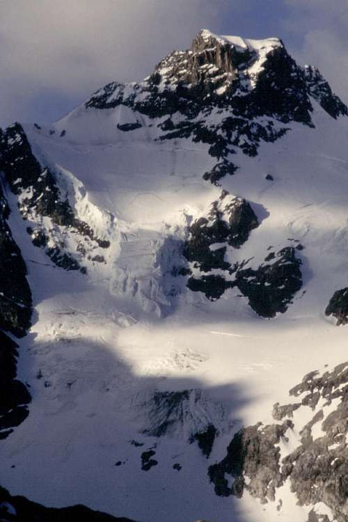
Detail of Cerro Dos Picos South Face |
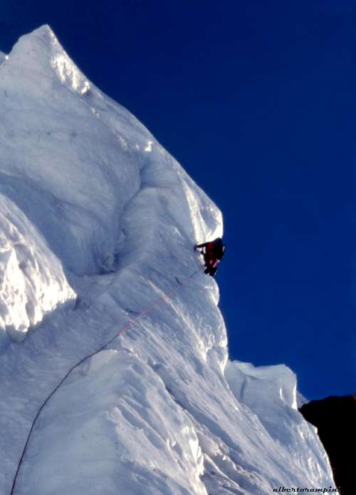
Zorro Colorado seracs wall |
Descent: downclimb the rocky West ridge (one abseil) reaching the rocky saddle; from here continue down along the ridge, more and more easily, reaching a col (Paso Hermoso), situated between Cerro Dos Picos and Cerro Hermoso. Descend towards South along some gently angled snow slopes, leading down to the moraine and the Base Camp.
Essential Gear
Rope, helmet, two technical ice-axes, crampons, ice-screws
Red Tape
The argentinian side of San Lorenzo Group is located inside "Francisco Perito Moreno" National Park. There are not particular restrictions in climbing and hiking.
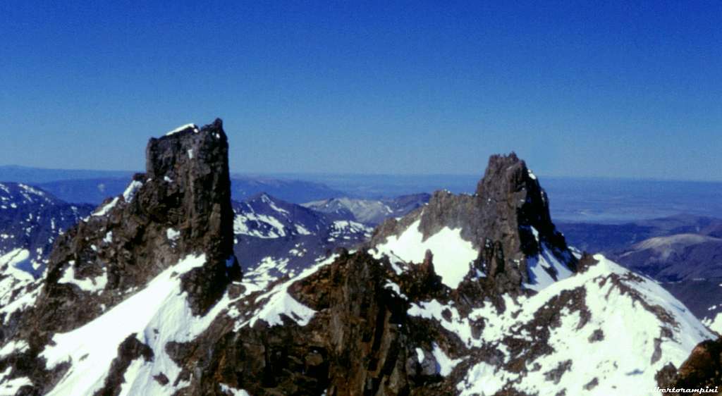
Summit of Cerro Dos Picos
When to climb
The best time to climb is from November to late February
Meteo
External Links
Tecpetrol Cuadernos Patagonicos - San Lorenzo - in Spanish
Guidebooks

"Patagonia Terra Magica per Alpinisti e Viaggiatori" - Gino Buscaini and Silvia Metzeltin