Mts Shasta and McLaughlin Trip Report; Late Season Conditions June 28-July 03, 2007
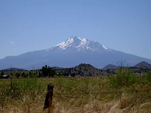
![Mt Shasta North Aspect]() Mount Shasta from the north.
Mount Shasta from the north. |
Introduction
“Oh no” I can hear you saying, “not another Mt Shasta trip report”. We’ve had 5 on SP already in 2007 and here’s another guy with the same old story to tell about schlepping his sorry ass up Avy Gulch gasping for breath and telling us that it was the soul awakening experience of a lifetime. Well actually it wasn’t. It was more about finishing a job started in 2005. It was a real bloody grunt. And there were far too many people about for my taste. Nevertheless, there was a considerable amount of value in the trip that I considered worth sharing with fellow SP-ers.
It’s been quite a while since anyone posted a TR on the conditions to be expected and the challenges posed by a trip up Avy Gulch in late season and/or low snow conditions. And even those older reports have a dearth of photos to illustrate such conditions. Our trip passes muster on all these counts I believe.
There is a wealth of history and culture in the southern Oregon/northern California area that we took the opportunity to sample while down there and that, if you haven’t already, you might find interesting to note for your next trip.
And if you like the main course, I’ve chucked in Mt McLaughlin for dessert. After the grunt up Shasta it makes a lovely mellow wind-down day and lets you look back south to your achievement on Shasta as well as north to many more of the Cascade volcanoes.
Have I piqued your interest? No? Well at least just have a look at all the nice pictures then.
June 28
Something new for southern Vancouver Islanders heading south is the ability to reserve on
the MV Coho to Port Angeles. This means we can clear US Customs quickly, enjoy a pleasant drive down Hood Canal rather than battling nose-to-tail traffic on 300 unwanted kilometres of I5 and, best of all, miss Seattle and Tacoma entirely as well as most of Olympia. This saves at least 2 hours and, since there’s a 6 am sailing in summer, means we get more than a 3 hour jump on the standard BC Ferries route.
My buddy Graham and I left Victoria by this method on June 28th and arrived hardly at all the worse for wear in Mount Shasta City at 6.15 pm and just over 1000 km later. Lots of time to clean up, have a leisurely dinner and then get a long nights sleep before the big effort over the coming couple of days.
A note, however, on one negative issue. Knowing we might be late getting in, we’d thought it wise to reserve a room in Mt Shasta for arrival. An accommodation-in-Mt-Shasta thread in one of the SP forums a couple of weeks beforehand had come down strongly in favour of the Swiss Holiday Lodge. So I reserved there in spite of the unfriendly and off-hand attitude of the guy I spoke to on the phone. It turns out that his attitude was pretty representative of the place. I’d thought that classic 60’s “naugahyde specials” had long since disappeared from the planet. Well they’re alive and well in Mt Shasta in the shape of the SHL. Paper thin walls, shaking floors, cracked mirrors and, of course, that fabulous imitation wood. In fact, I think even the plastic was imitation. All coupled with unfriendly reception staff and a bill for about Can$100 this made for less than sterling value for money.
Looking around Mount Shasta, there are no Holiday Inns, Comfort Inns, Super8’s, Motel6’s etc. Do I smell a strong presence of local hotel owners on the board of the town’s Chamber of Commerce and the deliberate exclusion of these value-for-money hotel chains?
June 29; to Lake Helen
The standard first day on any 2-day trip up Shasta is mostly about hauling a big pack up to the 50:50 or Lake Helen campsites for the night. We’d done the same in 2005 on snow right from the car at Bunny Flat. What a contrast 2 years on! An easy trail to Horse Camp and not much more in the way of effort thereafter. Normally I’d rather climb snow than dirt but this trail was well laid out, contoured and was mostly firm underfoot. What volcanic scree there was was very user friendly.
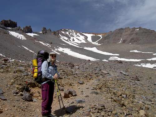
![Approach to Lake Helen]() Approaching Lake Helen, June 2007
Approaching Lake Helen, June 2007 | ![Approach to Lake Helen]() Approaching Lake Helen, June 2005
Approaching Lake Helen, June 2005 |
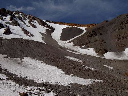
As we progressed beyond Horse Camp it soon became apparent how different things were from our 2005 trip. As mentioned, we’d done this entirely on snow and, eventually, turned round in high winds and a whiteout just below the Red Banks. Now there was almost no snow to Lake Helen and for at least 300 vertical metres above it, the “Heart” was huge and the passage through the Red Banks was confined to one chute with continuous snow.
We left Bunny at 12.30 having enjoyed a leisurely morning in Mt Shasta and pulled into Lake Helen at 5 pm feeling tired but a long way from exhausted. The usual “head rushes” followed any abrupt movements but were not too bad considering we’d come almost directly from sea level to 3,200 metres.
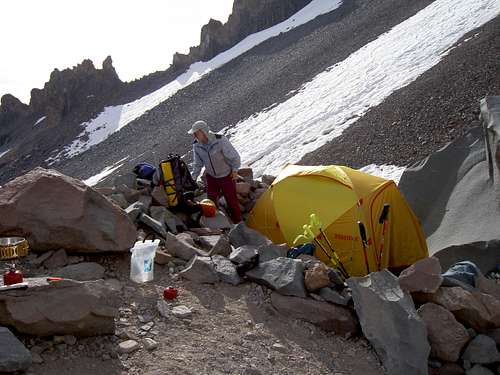
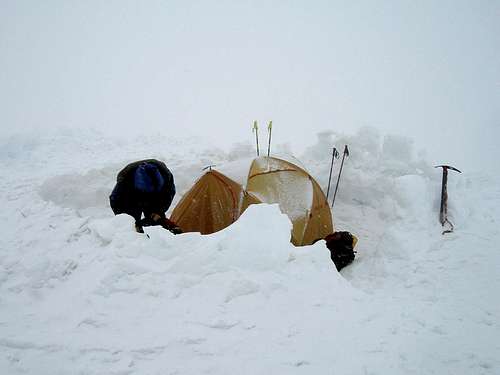
![Camp at Lake Helen]() Camp at Lake Helen, June 2007
Camp at Lake Helen, June 2007 | ![Camp at Lake Helen]() Camp at Lake Helen, June 2005
Camp at Lake Helen, June 2005 |
We set up camp on dirt right at the west end of the camping area and were immediately successful in finding flowing water just a few metres further to the west. So all the extra fuel I’d hauled up for melting snow was for naught. Oh well……….Our campsite was right next to a large boulder and this served to hang food from to isolate it from the attentions of the hoards of voracious mice up there.
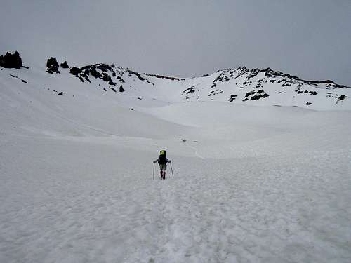
![Avalanche Gulch from Lake Helen]() Avalanche Gulch from Lake Helen, June 2007
Avalanche Gulch from Lake Helen, June 2007 | ![Avalanche Gulch from Lake Helen]() Avalanche Gulch from Lake Helen, June 2005
Avalanche Gulch from Lake Helen, June 2005 |
The rest of the evening was spent eating, drinking, marveling at the difference in conditions from our last visit and watching folk sliding down the glissade chute which appeared to comprise half the width of the remaining snow on climber’s right of the Heart. We were in bed well before 9 pm.
June 30; Lake Helen to summit to Bunny
![Avalanche Gulch]() Looking up Avy Gulch
Looking up Avy Gulch![Looking down Avalanche Gulch]() Looking down Avy Gulch
Looking down Avy Gulch![Above The Red Banks]() Emerging from the Red Banks.
Emerging from the Red Banks.![Misery Hill]() Bottom of Misery Hill
Bottom of Misery Hill![Mt Shasta Summit]() Summit from the top of Misery Hill
Summit from the top of Misery Hill![Mt Shasta Summit Tower]() Summit tower from the plateau
Summit tower from the plateau![Mt Shasta Summit Crowds]() Summit crowds
Summit crowds![Mt Shasta Summit View South]() Summit view south
Summit view south![Shastina]() Shastina
Shastina![Trail s End]() Trail's end
Trail's end
As always before summit day, I slept poorly and was awake well before the alarm went off at 3 am. We got up to crystal clear conditions, temperatures right on the freeing point and hardly a breath of wind.
An inauspicious start to the day, however. As one of the thieving mice was making off with some of my breakfast, I aimed a half-hearted kick after it. You can never catch these little beggars, right? Wrong! I booted it cleanly through the goalposts of life into the mouse-hereafter and immediately felt like s**t, convinced that somewhere in the next 1,200 metres up and 2,400 down, the Almighty was gonna get me for that. After a quick funeral service in the hopes of placating whoever was listening, we were off across the still frozen Lake Helen by headlight at 4.30 am.
As we’d observed from below, the first 300 vertical metres above camp was on dirt. A route on snow was being taken by others from the east end of Helen but involved a considerable detour. We chose the more direct route and prepared to do battle with loose choss. In fact it wasn’t too bad at all and we were soon able to don crampons and take to the snow just below the base of the Heart. We chose to go to the right at this point.
Climbing conditions were ideal. The snow was frozen and firm. However, since there was so little snow left, the sun cups were huge and when combined with the equally huge footprints of the hundreds who had gone before, made for quite unpleasant going with much side hilling. Added to this was the fact that something I’d ingested had disagreed with me. I had continuous stomach cramps and felt like throwing up most of the time. It was about then that I began to wonder about that flowing water near our campsite at Lake Helen….Finally at about 8 am and just below the Banks a lone boulder in the Heart offered privacy and I cramponed across 10 metres of 30° volcanic sand to reach it. Thereafter, my world got a whole lot better. At this point we had surpassed our 2005 high point and this also contributed to my newfound sense of well-being.
We were at the base of the Red Banks a few minutes later and were soon up the one icy chute that offered continuous passage. The angle eased off and we plodded on, still on snow and in increasing winds up to the base of Misery Hill by 9.30. Here the snow ended so we took off and stashed the crampons, put the axes on the packs and took out the poles once more.
Misery Hill wasn’t. Pleasant scree might sound like an oxymoron but, in this case, it wasn’t either. A contoured path and firm footing soon had us at the top with the summit tower in full view but with the winds now gusting up to 80 kph.
Across the summit plateau – exposed ice in places – up the last scree hill and we joined the crowds on top at 11.40 am. You almost have to reserve your spot on the summit for handshakes and photos. I see the day when a ranger will greet you, much like in a restaurant, and conduct you to your “table” for your carefully orchestrated 2 minutes in the spotlight. I shouldn’t be so cynical I know.
No complaints about the views though. Towering over everything for hundreds of miles around, as it does, Shasta is the paradigm of the expression “360° views”. Just fabulous!
Having had our moment in the sun, as it were, we dropped down a few metres out of the wind and had a well-earned lunch while continuing to enjoy said views.
We set off down just after 12.15 and reached the tent at Lake Helen at exactly 4 pm. For the most part the descent was the straightforward reverse of what we’d climbed. We faced-in twice briefly going through the Red Banks and we also walked down Avy Gulch rather than glissading. The sting in the tail was the last 300 metres of choss to the tent. At 4.30 am it had been frozen in place. Now it was loose, sharp, and unpleasant and cost a lot of effort. Avoid this if you can.
A quick brew, this time with well-boiled and treated water, pack up and we were off down to the car at 5.45. Horse camp came into view very quickly but it seemed to take ages to reach it. We reached Bunny at 9.05 just as it was getting dark.
Eschewing the charms of the Swiss Holiday Lodge, we went a few miles up I5 to Weed, whose Chamber of Commerce seems to be a bit less parochial and which, therefore, has name brand hotels for half the price of Mt Shasta. The Motel6 welcomed us with open arms. The problem with Weed, however, is that it – the whole town that is – closes at 9 pm. So if you stay there, make sure you arrive early, or keep a freeze-dried dinner or something in reserve.
After a 20 hour day to this point, unconsciousness arrived shortly after 11 and persisted for many hours thereafter.
July 01 (Canada Day); Steam and Shakespeare - Weed to Ashland, OR
This was to be our rest day.
Having traveled through it many times, I’ve long been fascinated with the area around Yreka and this was my chance to explore it further. In particular, and having grown up in the era of steam in the UK, I love old railroads. In 1873, The Central Pacific Railroad surveyed the region with the intention of building a subsidiary railroad in order to bring the rails through the city of Yreka and assure the continued growth and prosperity of the city. As big companies often do, they soon decided to walk away from the deal and left Yreka in the lurch, 7 miles from the main line in Montague. Not to be deterred, the citizens of Yreka decided to build their own spur line to connect with the CPR in Montague and, by dint of much hard work and dedication, they had accomplished this by 1889. Today the railroad operates as a tourist attraction covering the 7 miles between Yreka and Montague in just over an hour. It takes just under 10 minutes to drive, but that’s not the point.
![The Yreka Western Railroad]() The YWRR arriving in Montague, CA.
The YWRR arriving in Montague, CA.
I can’t imagine a nicer way to enjoy a rest day than Graham and I did. Sitting in the garden of Miss Lynn’s Tearoom in Montague watching the YWRR steam in, sipping tea and chowing down on crumpets and scones – now there’s civilised for you.
After drinking our fill at this historical fountain, we shot off down to Yreka (beating the train by 50 minutes of course) re-supplied at Ray’s Supermarket and shot off again over the state line and up to Ashland, Oregon.
For those who don’t know, Ashland is the site of one of the best-known Shakespearean festivals anywhere in the world outside the UK. It boasts an open air Elizabethan stage that is, supposedly, a faithful re-creation of the original Globe theatre in London. I’ve long wanted to go there and now was my chance.
Performances start at 8.30 pm and at 7.30 any remaining tickets go on sale for half price. We snagged two for Romeo and Juliet. Not my favourite work by the bard but you can’t have everything. Note also the pleasing symmetry of the "Montague" theme. Now all I have to do is find a "Capulet" in the area.
I wouldn’t exactly say I was disappointed with the performance but I have to say it left something to be desired. The stage management was wonderful and the lavishness of the production undeniable but I like my Shakespeare to be as unadulterated as possible. I could handle the mixed traditional and modern costumes without too much trouble but began to bristle a bit at the occasional lapses from what I consider to be the true dialogue. But what really got my goat were the modern “rap” gestures that the cast seemed to be prone to. A real audience pleaser to be sure and maybe the bard himself may have approved – but not for me.
These small peccadilloes notwithstanding it was a super day and left us raring to get back into the mountains on the ‘morrow – as Will himself might have said.
July 02; Mt McLaughlin
![Mt McLaughlin East Ridge]() Mt McLauglin east ridge and summit
Mt McLauglin east ridge and summit![North Face Moat]() North face moat
North face moat![Approaching McLaughlin s Summit]() Stepping onto the summit
Stepping onto the summit![Mt McLoughlin West Ridge]() West ridge
West ridge![Mt McLaughlin North Face]() Summit view down north face
Summit view down north face![View South to Shasta]() Summit view south to Shasta
Summit view south to Shasta![Mt McLaughlin Summit Nap]() Summit nap
Summit nap
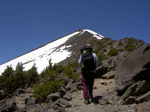
Up at 6.15 am, we bade goodbye to the Ashland Super8 at 7.45 and following
the excellent directions on Brian Jenkins’ SP page were at the trailhead and ready to go by 9.15.
In future, when I think of Mt McLaughlin, one word will spring to mind before all else. MOSQUITOES. Just one or two more of the little sods and they wouldn’t have to bite you on the spot. There’d be enough to pick you up, carry you off to wherever it is that mosquitoes go and have their way with you at leisure. I hate the buggers!!
So, it was out of the car, on with the deet, on with the sunscreen and then on with another layer of deet. Didn’t stop them biting though. However, it did get us moving in pretty short order.
I have only one tiny complaint about the excellent day that followed – apart from the mosquitoes (have I mentioned how much I hate them?). Out of 1200 metres of ascent, 750 metres are in the trees with little in the way of views. The trees section was soon accomplished, however, on excellent trail and we were at the “sandy saddle” at the bottom of the open section of the east ridge at 12.00 or so with some nice exposure down the north face to our right and the summit in full view ahead. The day was cloudless and windless. Marvellous!
The trail continues all the way to the summit mostly on climber’s left of the ridge crest. Sometimes we took it; sometimes we walked right on the edge overlooking the north face. There were a couple of residual snow patches to cross and we finally arrived on a sunny summit at 1.30 pm to be greeted by scores of butterflies.
Great views all round. To Shasta to the south, of course but also north to Thielson, Diamond and even the Sisters as well as a host of lesser summits. For once we had the whole thing to ourselves and enjoyed a quiet hour over lunch, photos and even a brief nap.
We left the summit at 2.30, went down the exact way we came up and were at the car at 6 pm. The last hour to the car was accomplished at a near run as we got low enough for the damned mozzies to home in on us once again.
Three hours later and it was pizza and beer time in Roseburg.
Thanks to the Coho, our final leg home the next day was a short one. No need to worry about all the Independence Day eve traffic around Seattle. We even had time to drop a few hundred dollars at gloriously sales tax and GST free REI in Tualatin.
What a great trip. But when is time in the hills anything else?
Page Visitor Statistics


Comments
Post a Comment