
-
 16717 Hits
-
 83.1% Score
-
 16 Votes
|
|
Route |
|---|---|
|
|
41.37269°N / 122.22668°W |
|
|
Hiking, Scrambling |
|
|
Spring, Summer, Fall, Winter |
|
|
Overview
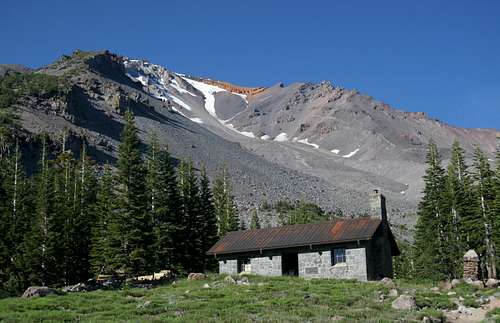
Mount Shasta above Horse Camp
Mount Shasta’s craggy countenance looming high above the old Sierra Club cabin at Horse Camp is one of the iconic images of California’s staggering volcano. It is such a memorable vista in part because it is simply an astounding view. Another reason for this being a defining image of the great mountain is because the trail to Horse Camp is one of, if not the most, heavily use trail on Mount Shasta. The reasons for the heavy use are as obvious as they are manifold.
First and foremost, the trail begins at Bunny Flat, one of the most popular trailheads on the Everitt Memorial Highway, the only paved road that climbs the high reaches of Mount Shasta. The highway begins in the town of Mount Shasta City, which means that not only is the road easy to drive but it is easy to access. Another reason the trail sees such heavy use is the relative paucity of maintained trails on the mountain. This tends to funnel the use onto a few, select trails, most of which begin at either Bunny Flat or the Old Ski Bowl. Lastly, and perhaps most importantly, the Horse Camp Trail is the first portion of the most popular route to the summit of Mount Shasta. Over 90% of the attempts on the summit begin at this point.
Mount Shasta above Hidden Valley
This begs the question, if the reasons for a trail’s popularity lie at its beginning or far beyond its terminus, is the trail itself a worthy route? The answer to this is that the Horse Camp Trail proper is a bit of mixed bag. Immediately beyond the Bunny Flat area, the trail enters the woods and essentially has no views until the arrival at Horse Camp. It is essentially a means to access other points on the mountain. This gives the Horse Camp Trail a bit of a dubious distinction from the other trails on Mount Shasta.
The other trails are generally out and back, with a specific destination. Most of the scenery on these trails is fantastic and much of their appeal lies in the journey as well as the destination. The Horse Camp Trail, on the other hand, has a bland journey that opens up the possibility for four or more possible destinations, all of which are first rate.
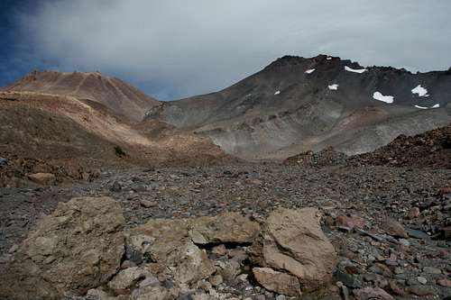
The four primary destinations of the Horse Camp Trail are Hidden Valley, Helen Lake, a hidden spring in Avalanche Gulch and Green Butte. Of these four routes, all but the hidden spring have routes leading to the summit of Mount Shasta.
The most popular route to the summit departs Horse Camp and climbs up Avalanche Gulch to Helen Lake. From there it heads to the top of the mountain. Several routes begin at Hidden Valley and climb to the summits of both Mount Shasta and Shastina. The route that leads to Green Butte also extends onward, up Green Butte Ridge and to the peak. The hidden spring-fed creek in Avalanche Gulch is the least known of these destinations but is an attractive destination.
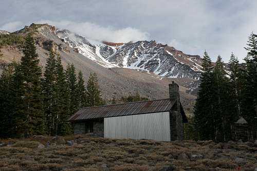
Horse Camp itself is a beautiful spot. The old Sierra Club cabin, called the Shasta Alpine Lodge, sits in the middle of a small meadow with Mount Shasta and the upper section of Avalanche Gulch looming high above. The cabin was originally envisioned as the first of a series of cabins en route to the summit.
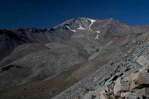
 Mount Shasta and Avalanche Gulch
Route Description
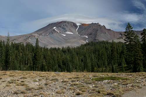
Lenticulars on Mount Shasta as seen from Bunny Flat
The Horse Camp Trail begins at Bunny Flat. The trailhead is a popular destination on its own. It has a spectacular view of Mount Shasta as well as great views to the south, including Lassen Peak. Although there is a network of paths permeating the flat, the official trail begins next to the bathrooms, where an official trailhead sign marks the beginning. Running along the perimeter of the flat, the path climbs moderately and then reaches a junction where it makes a sharp turn to the left. If one turned right, one would be following the route that leads to Green Butte.
Once the path makes its turn away from Bunny Flat, it crosses a small gully. This is, in fact, the remnants of massive Avalanche Gulch, it having narrowed tremendously from its gigantic size further up the mountain. Immediately after crossing the gully a trail branches off to the left. This is a use trail that heads down to Sand Flat. The Horse Camp Trail enters the forest after leaving Bunny Flat and remains there throughout the journey to Bunny Flat. Nonetheless, there are a few points with partially obscured views of the Trinity Divide and Trinity Alps to the west. About 0.5 miles from the trailhead, the trail path passes another use trail branching off to the left. This connects to the Sand Flat trailhead. Stay to the right and continue climbing up the rock strewn trail.
Another 0.25 miles further, the trail passes a tower of some type, likely housing weather gauges and such. Just beyond this point the trail crosses a clearing and then reaches a junction with the Sand Flat Trail. This trail is an alternate trailhead to reach Horse Camp. It is 0.1 miles shorter than the trail from Bunny Flat but it gains 300 more feet. Once past the junction, the route makes a long, sustained climb all the way to Horse Camp. Along the way, it first enters the Mount Shasta Wilderness and shortly thereafter it crosses the boundary of the land owned by the Sierra Club. As it climbs, the trail passes above the gully previously crossed by the trail. Here it has widened out significantly, though still not the epic canyon it becomes a little further up. Above the trail one can at times see the remnants of an earlier iteration of the route, the current pathway being a regraded route. Finally, the trail makes a swing to the north and then, 0.75 miles from the junction with the Sand Flat Trail, it reaches Horse Camp. The view of the cabin with the mountain looming high above is one of the iconic images of Mount Shasta.
Horse Camp is a hub of backcountry activity on Mount Shasta. The cabin itself is occupied by a caretaker who lives there during the summer. Spring water is piped in and cascades down an attractive rock pile. Campsites are available for a small fee and there are solar-degrading toilets available as well. There is also a library inside the cabin.
While many hikers might be satisfied with stopping at Horse Camp, there are several more destinations that are easily reached as part of a day hike. For those intent on reaching the top of the mountain, Horse Camp may serve as a basecamp. There are additional basecamps higher up along these routes. The places that make good additional destinations are Hidden Valley, Helen Lake, the hidden spring of Avalanche Gulch and Green Butte. Other than some portions of the trail to Helen Lake, all of the trails beyond Horse Camp are unofficial and consequently unmaintained.
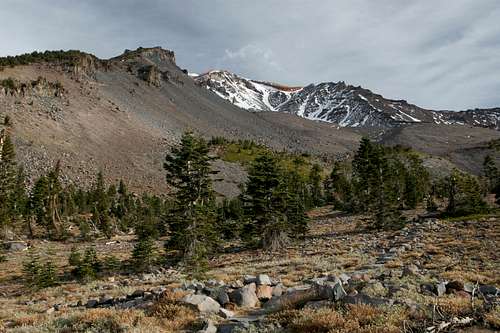
Mount Shasta and Shastina over Hidden Valley
Hidden Valley
The trail to Hidden Valley is short but steep. It departs Horse Camp to the north. To find the trail, walk to the northeast corner of the cabin. From there the trail heads out toward the base of Casaval Ridge, passing a few of the campsites along the way. From there the trail proceeds through the forest for a short distance, remaining fairly level. Soon the trail makes a short but steep ascent over a small ridge and enters a small bowl that funnels off to the west. The bowl is fairly treeless and views to the west open up.
Beyond the bowl the trail climbs steeply again, eventually crossing another ridge and entering an even larger basin. Once again views are good as the trail climbs the mostly treeless basin and once again, upon reaching the far side, the trail climbs steeply again. Although the route to Hidden Valley consists of an unmaintained use trail, the path is pretty obvious. Despite this the Forest Service will often place small flats marking the path. This is intended to keep people from getting lost but also to channel use onto the worn path and spare other areas from wear and tear.
On the far side of the second, larger basin, the trail passes through a stunted forest of whitebark and lodgepole pine. Beyond this the trail’s grade is a bit more moderate even though it still climbs at a good clip. The route traverses a final, steep talus slope that rises above the lower portions of Cascade Gulch. The views from this section are great, taking in the entirety of Strawberry Valley, the Trinity Divide, the distant Trinity Alps and Marble Mountains and the Sacramento Valley far to the south. As it climbs, the trail is angling for an obvious notch. During much of the season water melting high above the valley is funneled through this notch and cascades down the eponymously named gulch.
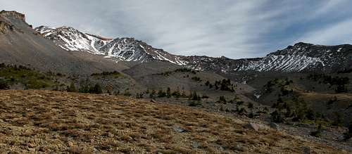
Hidden Valley, at 9,200 feet is a spectacular basin almost 5,000 feet below the summit of Mount Shasta. The summit itself is not visible from the valley and the highest point above the area is only 4,000 overhead. On the north side of the valley is Shastina, Mount Shasta’s great secondary cone. Campsites are found on both sites of the notch. From here routes up Mount Shasta include Casaval Ridge, West Face Gully and Cascade Gulch. The primary route up Shastina begins here as well.
Olberman's Causeway
Helen Lake
The trip to Helen Lake is more likely undertaken as part of an attempt on the summit of Mount Shasta. For much of the season, and depending on the volume of snow that fell during winter, reaching the lake may require crampons and ice axe. Also, depending on the aforementioned variables, the lake itself may be covered with snow and not visible.
The trip to the lake begins at the Horse Camp cabin and departs from near the fountain. It consists of a series of large rocks lined up to form stepping stones. This is known as Olberman’s Causeway, built by the Lodge’s first caretaker, Joseph Olberman. The causeway extends almost 0.5 miles up the mountain and connects to the use trail that leads to Helen Lake.
Beyond the causeway, the trail climbs steeply over loose sand and rock. At times there are a few alternate routes but the most often used trail is easy to discern. Nearer to Lake Helen the trails becomes harder to make out. Snow often covers this area. Helen Lake can often be quite busy, especially on weekends and around holidays.
The view south from Avalanche Gulch
Avalanche Gulch Creek
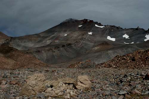
The hidden spring-fed creek in Avalanche Gulch is the least visited destination that departs from Horse Camp. Other than along the creek fed by the spring in Avalanche Gulch, this area is only visible from Green Butte Ridge, where the cascading creek is audible from high above. The spring itself is secreted away high up in the deep recess of Avalanche Gulch. However, there is an attractive, meadow bound cascade that is reached relatively easily from Horse Camp. To do so, proceed eastward on the trail that is immediately to the right of the beginning of Olberman’s Causeway. This trail traverses the base of Avalanche Gulch, just at timberline.
The view of the upper gulch is spectacular. A little more than 0.25 miles brings one to the edge of Avalanche Gulch itself. While the whole drainage lying between Casaval Ridge and Green Butte Ridge is referred to as Avalanche Gulch, this is the gulch itself, the primary drainage for runoff between the ridges. It is more fittingly called a gulch as opposed to the massive valley that normally carries the name. From here the trail drops down into the gulch itself, continuing on the side of the gully.
The quality of the trail degrades substantially as once climbs up the gulch. At times the trail pops up above the rim of the gully with awesome views of Mount Shasta and upper Avalanche Gulch. Eventually the trail gives out altogether and scrambling over rocks at the bottom of the gully and over some sections of loose scree is required to finally reach the meadow cascade. This area is marked by a small band of cliffs, distinct from the mounds of loose scree that typifies the area. The cascade and its narrow ribbon of meadow is an isolated a beautiful spot.
Avalanche Gulch from the route up to Green Butte
Green Butte
The final option for the Horse Camp Trail is to climb Green Butte. This is a scenic butte that overlooks the Old Ski Bowl, which is on the far side of Green Butte Ridge. The Green Butte Ridge Trail also climbs the Butte and is shorter and steeper than the route that comes from Avalanche Gulch. The Green Butte Ridge Trail also begins at Bunny Flat so a nice loop can be constructed. If this is the case, the recommended route would be to hike to Horse Camp, climb Green Butte and then descend down the Green Butte Ridge Trail back to Bunny Flat. This means the more scenic parts of the trail are hit first and the ascent is more gradual. The return trip would be quick and direct.
To reach Green Butte, proceed from Horse Camp on the trail that leads to the hidden spring-fed creek in Avalanche Gulch. When the trail hits the gulch proper, straight ahead there is a bench hosting a few stunted trees halfway up Green Butte Ridge. Leave the trail, cross the gulch and scramble up the rocky slope to the bench. From the bench scramble the rest of the way to the top of the ridge. From there it is a steep climb up loose talus to Green Butte. More details on that can be found herehere.
Map
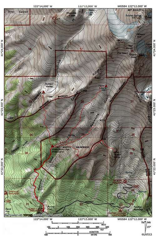 Horse Camp Trail
Getting There
Winter preparations at Horse Camp
On I-5, take exit 738 for central Mount Shasta. Proceed east on Lake Street, through the intersection of Lake and Mount Shasta Boulevard. The road continues east and bends to the north, reaching an intersection by Mount Shasta High School. Pass through the intersection, which becomes Everitt Memeorial Highway. Stay on the highway for 11 miles to the Bunny Flat Trailhead.
External Links
Shasta-Trinity National Forest