
|
|
Route |
|---|---|
|
|
41.40940°N / 122.1939°W |
|
|
Basic snow climb |
|
|
One to two days |
|
|
Walkup or a bit harder if icy |
|
|
Overview
The Hotlum Wintun "Ridge" is not really a ridge per se, but more of a snowfield. This prominent snowfield drapes down the east side of Mount Shasta and, as the name implies, separates the Hotlum and Wintun Glaciers. The route is quite straightforward -- easier and safer, in my opinion, than the trade route up Avy Gulch (factoring in Red Banks and the heinous rockfall), and much more fun. You'll also see about 1% of the people you would see on the south side.
Most importantly, the H-W is one of the best ski runs anywhere. Deep into June, July and even August in big years, the H-W serves up about 6,000-7,000 vertical feet of blissful corn snow.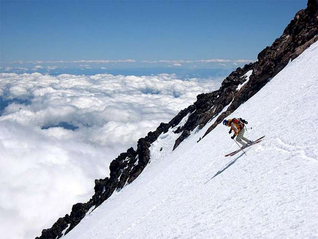
 |
 |
 |
Approach
The trailhead for this route is Brewer Creek, on the east side of Mt. Shasta. The trailhead is very well signed from Highway 89 (coming from the south) or from Highway 97 (from the North).
From the North: Take US 97 north from Weed. 12 miles after Weed, turn right on Military Pass Road (Forest Service Road 19). Go more than 10 miles down this road, where you join with Forest Service Road 31 for a short period. Then, go right onto Road 42N02. After around 2.5 miles turn left onto 42N10, and take this to the trailhead at the end.
From the South: Exit I-5 onto US 89 towards McCloud. Drive through McCloud. About 2 miles east, turn left onto Pilgrim Creek road. You will see signs here for Brewer Creek. It is paved for a ways, and then you get onto Military Pass Road (again, well signed). Then, go left onto Road 42N02. After around 2.5 miles turn left onto 42N10, and take this to the trailhead at the end.
The road is pretty good dirt for the last 10 miles or so, and only gets rough in the last mile or so. Definitely passable by regular cars.
 |
 |
 |
 |
 |
Route Description
From the trailhead, follow the trail which first heads south across the lower flank of the mountain for about 1/4 to 1/2 mile. Then it needlessly switchbacks upwards towards treeline. The trail peters out pretty quickly near treeline, but by then the route is obvious.
Standing at treeline and looking up at Shasta, you will have a large moraine just up and to your right. Brewer Creek flows just to the left (south) of this big moraine, but likely will be buried by snow and invisible. Hike up the obvious drainage, keeping south of this big moraine. It gets steep between around 8,600' and 9,600'. At 9,600' a small bench flattens out briefly and there is a good campsite here among the rocks which usually has running water by mid- to late-spring.
From here, the route is easily discerned in front of you. Climb upwards onto the big snowfield that is south of the Hotlum Glacier, angling left towards the narrow spine of rocks that separates the snowfield from the Wintun Glacier on the left. Ascend on the climbers' right side of this spine of rocks until you get underneath a prominent buttress with a chute coming down the middle of it. From here, traverse left above the Wintun Glacier and ascend a very wide chute up to the summit rocks.
Alternatively, climb the big snowfield along its right side, skirting the edge of the Hotlum Glacier. You'll get a great look at the huge icefall, but don't get too close unless you're comfortable travelling on crevassed glaciers. When you approach the top of the snowfield climb a chute in between the Hotlum Headwall and the buttress described above. This chute can be pretty icy, so this is not the beginner route.
 |
 |
 |
 |
 |
Essential Gear
axe and crampons is all you need, but if you're smart, you'll bring skis or a splitboard too.
rhyang - Sep 4, 2006 6:00 pm - Voted 10/10
Ice ChuteThe chute just above the Hotlum-Wintun snowfield seemed to be iced up on 3-Sept-2006, so we climbed that instead of traversing to the climber's right over the rock into the ice gully to the left of the Hotlum Headwall. The ice was mostly about 35-40 degrees, highly featured, and fairly aerated near the surface, but good blue ice underneath. Maximum angle I would guess was about 40-45 degrees, with slightly steeper bulges here and there.