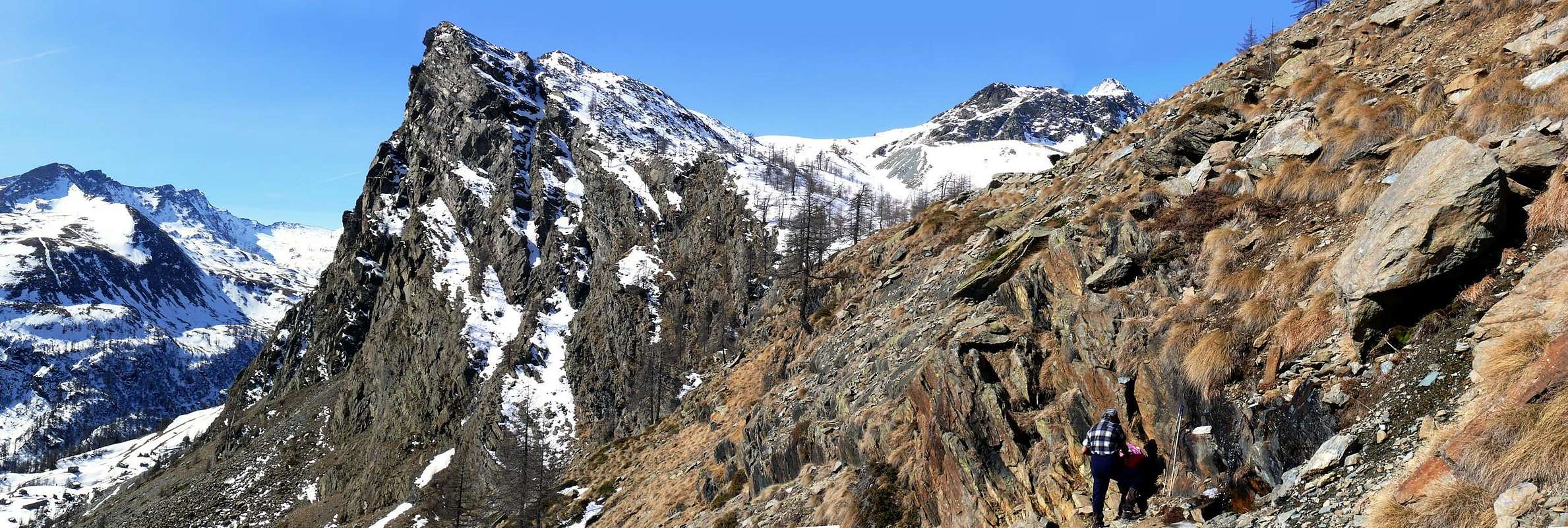
For how much subjugated by the two well more elevated pyramids of the Mont Delà (3.139m) and of the Mont Mont Glacier (3.186m; taller peak of the whole subgroup to which it gives the name), this particular top, lengthened for over a kilometre on the axle East/West, becomes for the Municipality of Champorcher representative, being well in sight already actually to before the entrance in the village chief town of the homonym valley. He should be written not of the Bec Raty, on the contrary of the Becs Raty to plural, since the whole mountain results formed by an Antesummit East and by three points (East, Central and West) perfectly prepared on-line on the same ridge watershed, dividing the central valley from the Vallons of Sapy-Raty-Bocon to East, as well as from that of the West Giasset to the slopes of a basin contained between the Mount Glacier and the Gran Rossa (= Great Red Mountain; 2.866m). Along both you/he/she can always happen the slope with analogous departure on the road "poderale" in earth also Savoia Royal Route for Dondena (2.100m; 10 Kms around from the chief town, with open traffic for the cars), but rather outdistanced from different Kilometres. Its more interesting slope is certainly "alpinely" and mountaineer that Southern, that falls on the stony grounds of the underlying aforesaid road with tall walls from 200 to 300 meters and on which are been traced some beautiful "streets" of rock, attractive also for the tied up factor to the a lot of brief march of approach. On these lines unhomogeneous are found with alternate good rock with very more sectors "broken" and also with grass and soil, according to the select routs (numerous spits in place). On the opposite, or Northern slope, very steep slant and composed by rocky plates more abandoned and routs, alternate to lines grassy debris and blocks, make easy, if not elementary, the slope; the crossing in crest, in the one or in the other sense, introduces some brief interesting and amusing passages instead, with great South exposure. Trip easy excursion, becomes more binding if completed through in winter the skis or of the snow rackets or snowshoes; it allows besides different "liaisons", through fanciful personal choice, with the neighbour Points of the Gran Rossa, of the Bocon of Amon (= of Superior Level) and the more "small" Mount Ros and Bec Barmasse, minuscule pulpits-promontory, that they place side by side them to East constituting the logic of it prosecution from the point of view geo-morphological . Narrow, limited and local sights, seen the most elevated district, that they are placed on the trio Mont Moussaillon, Delà and Glacier, toward Northwest, and on the beautiful pyramid of the Rosa of the Banchi (3.164m; second top of the Champorcher Area), frontally and opposite to South.
Per quanto soggiogata dalle due ben più elevate piramidi del Mont Delà (3.139 m) e del Mont Mont Glacier (3.186 m, vetta più alta dell'intero sottogruppo al quale dà il nome), questa particolare cima, allungata per oltre un kilometro sull'asse Est/Ovest, diventa rappresentativa per il Comune di Champorcher, essendo ben in vista già sin davanzo all'entrata nel villaggio capoluogo dell'omonima valle. Dovrebbesi scrivere non del Bec Raty, bensì dei Becs Raty al plurale, poiché l'intera montagna risulta formata da un Antecima Est e da tre punte (Est, Centrale ed Ovest) disposte perfettamente in linea sullo stesso crinale spartiacque, divisorio la valle centrale dai Valloni di Sapy o Chapy-Raty-Bocon ad Oriente, nonché da quello del Giasset ad Occidente alle pendici di una conca racchiusa tra il Mont Glacier e la Gran Rossa (2.866 m). Lungo entrambi i medesimi può avvenire la salita con analoga partenza sempre sulla Strada poderale sterrata o Strada Reale dei Savoia per Dondena (2.100 m 10 Km circa dal capoluogo, con traffico aperto per gli automezzi), ma alquanto distanziata da diversi Kilometri. Il suo versante alpinisticamente più interessante è certamente il Meridionale, precipitante sulle pietraie della sottostante suddetta strada con pareti alte da 200 a 300 metri e sulle quali sono state tracciate delle belle vie di roccia, attraibili ed attraenti anche per il fattore legato alla brevissima marcia di avvicinamento. Su queste si riscontrano tratti disomogenei con roccia buona alternata con settori molto più "rotti" ed anche con erba e terriccio, a seconda delle vie scelte (diversi spit in sito). Sul versante opposto, ovvero Settentrionale, pendii alquanto meno ripidi e compositi da placche rocciose più adagiate e rotte, alternate a tratti erboso-detritici e blocchi, rendono facile, se non elementare, la salita; la traversata in cresta, nell'uno o nell'altro verso, invece presenta alcuni brevi passaggi interessanti e divertenti, con grande esposizione a Sud. Gita escursionistica facile, diventa più impegnativa se compiuta d'inverno per mezzo di sci o delle racchette da neve; permette inoltre diverse "liaisons", tramite fantasiosa scelta personale, con le vicine Sommità della Gran Rossa, del Bocon d'Amon e dei più "piccini" Mont Ros e Bec Barmasse, minuscoli pulpiti-promontorio, affiancantili ad Oriente costituendone la logica prosecuzione dal punto di vista geomorfologico. Viste ristrette, ridotte e locali, visto il più elevato circondario, che si posano sul trio Mont Moussaillon, Delà e Glacier, verso Nordovest, e sulla bella piramide della Rosa dei Banchi (3.164 m seconda vetta della Valle di Champorcher), frontalmente e dirimpetto a Sud.
First Ascents
First on the Summit: Unknown.
In Winter: Unknown.
Getting There
BY CAR:
From Torino, Milano, etc: Motorway A5. Exit Pont Saint Martin for then to continue on SS.26 toward Hone Bard.
From Switzerland: through the Grand Saint Bernard Tunnel or the namesake pass. Drive to Aosta, Fénis Village or Verrès and Hone Bard.
From France: through Mont Blanc Tunnel or Petit Saint Bernard Pass. It isn't necessary to take Motorway A5: you can drive on SS.26, in the direction of Aosta and Fénis Village or Verrès and Hone Bard.
BY PLANE:
Aeroporto "Corrado Gex" Saint Christophe (Aosta).
Approach
From the exit of Motorway to Pont Saint Martin reach, through a Main Road, Donnas Commune: immediately after the village (interesting view on the adjoining road to console adorned by a beautiful Roman arc). Some hundred meters, to the of near of I approach Dora Baltea Stream, bridge of the to cross they govern the indication Champorcher; to follow the Regional Road for this place. Of to go beyond the of Commune Pont Bozet the to reach the Village-Chief town called Chateau (= Castle; immediately is found the indication to Fraction Petit Mont Blanc. Road of this to follow, not too much great, for different km; the first part of the same one is in asphalt for then to continue in beaten earth. Usually the conditions of this second are enough good and however it are worthwhile to ask for information in the zone, considering that lately works of government maintenance are performed. Road of this to continue, the ancient one of they govern of coincident Real Road, octave flute than to the of until and underlying the Dondena little Village, near the Torrent Ayasse (2.100 meters; at the end a signal it prevents the traffic, immediately in the narrow as well as limited parking lot; poster signallers in cover of bench of an in wood; great crowd confusion of relative of and; a feet 1h'30/2h'00 from the term of the asphalted road).
Dall'uscita dellAutostrada in Pont San Martin raggiungerre Donnas: immediatamente dopo il villaggio (interessante veduta sull'attigua strada consolare ornata da un bel arco romano. Alcune centinaia di metri, appresso vicino alla Dora Baltea, attraversare il ponte con l'indicazione Champorcher; seguire la strada regionale per questa località. Oltrepassare il Comune di Pont Bozet e raggiungere il Villaggio del Capoluogo di Chateau; subito a monte della strada si trova l'indicazione per la Frazione del Petit Mont Blanc. Seguire questa strada, non troppo grande, per diversi km; la prima parte della stessa è in asfalto per poi proseguire in terra battuta. Di solito le condizioni di questa seconda sono abbastanza buone e comunque conviene richiedere informazioni in zona, visto che ultimamente sono state eseguite opere di manutenzione. Seguire questa strada, coincidente con l'Antica Strada Reale, fino al piccolo e sottostante Villaggio di Dondena, presso il Torrente Ayasse (2.100 m al termine un segnale impedisce il traffico, subito dopo il ristretto nonché limitato parcheggio; cartelli segnalatori in una panchina coperta in legno; grande folla e relativa confusione; a piedi 1h'30/2h'00 dal termine della strada asfaltata).
Route A
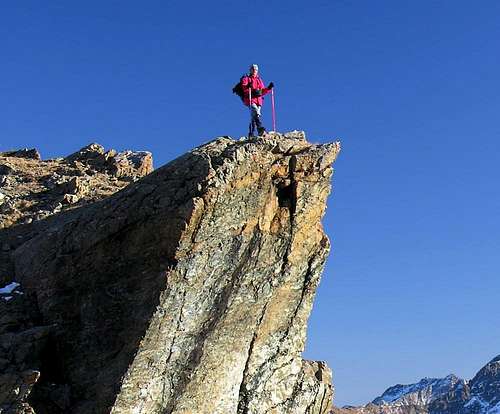
From the Giasset's Vallon, passing through the homonym loch and "colletto": To continue for brief I treat with the road in earth that, gone beyond a second smaller parking lot, continuous toward North reaching the Alp of the Giasset, where it finishes (2.057m); to continue with the path n° 9C more toward Northeast reaching the homonym and small lake (2.308m; T; 0h'30). From this, leaving to the left (North) a slender trace along the frontally floor Walloon that is addressed toward the two Necks of the Gran Rossa, to decidedly turn to East and, with steep run, to reach the small hill impending, called on the spot "Little Collar of the Giasset" (2.370m around); from the pass, with brief and easy slope toward South, to reach through a small path the Western Bec Raty, the most elevated of the three (2.417m; 0h'45 from the Lake Giasset; 1h'30 in total from Dondena Village). To cross to the Central Bec Raty (2.399m, second elevation in height: very evident for his form to roof above the great jump toward South) to follow toward East the crest watershed and, with run sure and beautiful views on the underlying Wall South, to reach it after having overcome on the left (North) to small, brief as well as amusing passage "of strength" (4/5 meters; Ii°/II°+; 0h'15). The third Bec or Oriental (2.382m, I.G.M. = Italian Institute Geographic Military), always followed by a lower East Great Shoulder, it is found more distant and it asks for a greater appointment introducing some most complex characteristics, with some most complicated passages, difficult and rather more statements, always on the right.
Dal Vallone del Giasset, transitando per gli omonimi lago e "colletto":Continuare per breve tratto con la strada in terra che, oltrepassato un secondo più piccolo parcheggio, portarsi verso Nord raggiungendo l'Alpeggio del Giasset, ove termina (2.057 m); continuare con il sentiero n° 9C più verso NE raggiungendo l'omonimo e piccolo lago (2.308 m T; 0h'30). Da questo, lasciando a sinistra (N) una esile traccia che si indirizza sul fondo dell'antistante vallone verso i due Colli della Gran Rossa, voltare decisamente ad E e, con percorso più ripido, raggiungere il piccolo colle soprastante, detto in loco "Colletto del Giasset" (2.370 m circa); dal colle con breve e facile salita verso Sud raggiungere per mezzo di un piccolo sentiero il Bec Raty Occidentale, il più elevato dei tre (2.417 m0h'45 dal Lago Giasset; 1h'30 in totale da Dondena). Per attraversare al Bec Raty Centrale (2.399 m, seconda elevazione in altezza: molto evidente per la sua forma a tetto sbilanciata sopra il grande salto verso Meridione) seguire verso Est la cresta sommitale e, con percorso sicuro e belle vedute sulla sottostante Parete Sud, raggiungerlo dopo aver superato sulla sinistra (Nord) un piccolo, breve nonché divertente passaggio "di forza" (4/5 metri; Ii°/II°+; 0h'15). Il terzo Bec od Orientale (2.382 m I.G.M.), seguito da un più basso Spallone sempre Est, si trova più lontano e richiede un maggiore impegno presentando delle caratteristiche più complesse, con dei passaggi più complicati, difficili ed alquanto più esposti, sempre sulla destra.
Route B
From the Vallone of the Raty, transiting for the homonym lake and "Collar of the Giasset": from the Real Road/High route n° 2, after the rectilinear long coming from the Alp-Village La Cort (1.880m around), to reach a first alternative with the descriptive poster "Raty"; abandoned the Real Road, to continue first toward Northeast and then Northwest through the road in earth, here coincident with the path-mule-track 9C, that salt through the wood. To reach so the Alp Sapy (1.979m), where the in soil road "poderale" it has end; to continue with the same path, but more moved toward North (beautiful small fountain gushed out from the rock; splendid sights, little by little that it rises us, on the East Wall of the Great Shoulder of the Oriental Bec Raty), going beyond on the left (West) a short rocky band, at the base of Southerner Slope of Bec Barmasse. You enters therefore the impending and mostly level Walloon of the real Raty, crossing the homonym Torrent, really under the reddish and rocky Wall I Know about the Bec Barmasse (2.296m); forded few over another branch of the same stream, the Pasture it is reached Raty Dèsot (= Lower; 2.241m) and, I immediately approach, the intersection with the path coming from the Lacke Vernouille (2.145m) and from the Alps Raty de Fort (2.229m) and Raty (2.274m). Immediately later, easily with the same, the beautiful Lake is reached to Raty (2.283m) with its vast banks, really proper to a good person "siesta" gastronomy (1h'00); from the lake, revolved to the left (South) its Southern bank, with a half dozen of hairpin bends and an enough long diagonal toward West the is reached "Collar of the Giasset", from where to the preceding route (1h'30/1h'40).
Dal Vallone del Raty, transitando per l'omonimo lago e "Colletto del Giasset":Dalla Strada Reale/Alta Via n° 2, dopo il lungo rettilineo proveniente dall'Alpe La Cort (1.880 metri circa), raggiungere un primo bivio con il cartello segnaletico "Raty"; abbandonata la Strada Reale, continuare prima verso NE e poi NO tramite la strada in terra, qui coincidente con il sentiero-mulattiera 9C, che sale attraversando il bosco. Raggiungere così l'Alpe Sapy (1.979 m), dove la strada "poderale" ha fine; proseguire con il medesimo sentiero, ma più spostati verso Nord (bella piccola fontana sgorgante dalla roccia; splendide viste, a poco a poco che ci si innalza, sulla Parete Est dello Spallone del Bec Raty Orientale), oltrepassando sulla sinistra (O) una corta fascia rocciosa, alla base Meridionale del Bec Barmasse. Si entra dunque nel soprastante e maggiormente pianeggiante Vallone del Raty vero e proprio, attraversando l'omonimo Torrent, proprio sotto la rossiccia e rocciosa Parete SO del Bec Barmasse (2.296 m); guadato poco oltre un altro ramo dello stesso torrente, si raggiunge l'Alpe Raty Dèsot (2.241 m) e, subito appresso, l'incrocio con il sentiero proveniente dal Lac Vernouille (2.145 m) e dalle Alpi Raty de Fort (2.229 m) e Raty (2.274 m). Subito dopo, facilmente con lo stesso, si perviene al bel Lago Raty (2.283 m) con le sue vaste sponde, proprio adatte ad una buona "siesta" gastronomica (1h'00); dal lago, aggirata a sinistra (S) la sua sponda Meridionale, con una mezza dozzina di tornanti ed un abbastanza lungo diagonale verso Ovest si raggiunge il "Colletto del Giasset", donde alla precedente via (1h'30/1h'40).
Difficulty
The route can be considered from E/F and EE/A/F+ for the Central and Eastern Summits.
L'itinerario è da classificarsi E/F e da F a F+ per i due Raty Centrale ed Orientale.
Equipment
For Excursion and ski or snowshoes, in presence of strong snow.
Da Escursionismo con sci o racchette da neve, in presenza di innevamento.
Campings
Remember that free camping is forbidden (except for emergency reasons, over 2.500m, from darkness until dawn).
Mountain Conditions
You can get meteo information at the official site of the Regione Valle d'Aosta:
"Guida delle Alpi Occidentali" di Giovanni Bobba e Luigi Vaccarone C.A.I. Sezione di Torino Volume II (parte II), 25 Maggio 1896.
"Guida dei Monti d'Italia – Emilius Rosa dei Banchi-Parco del Mont Avic" di Giulio Berutto e Lino Fornelli - Club Alpino Italiano/Touring Club Italiano, Marzo 2005.
"Diari Alpinistici" di Osvaldo Cardellina e Indice Generale accompagnato da Schedario Relazioni Ascensioni 1964-2019 (inediti).
MAPS:
Ingenia "Parco Naturale del Mont Avic" Carta dei sentieri 1:25.000.
Enrico Editori Ivrea "Carta turistica del Canavese" 1:100.000
Enrico Editore Ivrea-Aosta "Gruppo del Gran Paradiso" 1:50.000.
L'Escursionista editore "Valle di Champorcher Parco Mont Avic" Carta dei Sentieri (11) 1:25.000.
L'Escursionista "Valle di Cogne" Carta dei Sentieri 1:25.000.
Children refers to the set of objects that logically fall under a given object. For example, the
Aconcagua mountain page is a child of the 'Aconcagua Group' and the 'Seven Summits.' The
Aconcagua mountain itself has many routes, photos, and trip reports as children.
Parents refers to a larger category under which an object falls. For example, theAconcagua mountain page has the 'Aconcagua Group' and the 'Seven Summits' asparents and is a parent itself to many routes, photos, and Trip Reports.

 7109 Hits
 86.85% Score
 23 Votes