|
|
Mountain/Rock |
|---|---|
|
|
40.78873°N / 110.39608°W |
|
|
Hiking |
|
|
Summer, Fall |
|
|
13064 ft / 3982 m |
|
|
Overview
We all know, intuitively, what terms like “mountain,” “hill,” “peak” and “summit” mean, yet they are not easily defined.
Conventionally a mountain is a landform that rises significantly above its surroundings, generally exhibiting steep slopes, a relatively confined summit area, and obvious prominence. Comparatively, a hill is a raised section of land, typically not as elevated or rugged as a mountain. Whereas the term summit conveys the topmost level attainable while the term peak suggests a highpoint among others.
The International Climbing and Mountaineering Federation defines a point on a mountain as a summit if it has a prominence of at least 300 metres (980 feet) and as a peak if it has a prominence of 30 metres (98 feet).
Adding further to the uncertainty of definition, the terms peak and summit, however, are often used interchangeably. For example, consulting a thesaurus, peak is listed as a synonym for summit. Similarly, one mountaineer might say “we reached the peak,” whereas another, speaking of the same mountain highpoint, might say “we summited.”
The dictionary supports the notion of a summit being the top or apex. In fact, Webster calls a summit the highest point. Along that line of thinking, I like to think of a summit as the highest point of a mountain, and peaks as other prominent highpoints contained along the same individual mountain mass. The term “massif,” is what is meant by individual mountain mass.
Clearly a single mountain is not limited to a single peak. Likewise, due to the colloquial use of terms neither is a single mountain limited to a single summit (in contrast to my preference of summit denoting the highest point of a massif). For example, North America’s tallest mountain, Denali, contains two dominate highpoints, which depending on the literature one is reading, are called the north summit and south summit, or north and south peaks. In fact, within a single article about Denali, south peak and south summit are often found to be used interchangeably. A similar interchangeability of terms can be found when speaking of almost any massif containing multiple peaks.
A sometimes victim of semantics is the “peak” along the Henrys Fork Massif officially labeled on maps as Cliff Point. Depending on who you talk to, Cliff Point is a Utah 13er or it’s not. A "13er" is a mountain peak with an elevation of at least 13,000 feet but less than 14,000 feet. In the opinion of David Rose who wrote the book Utah Thirteeners, Cliff Point unquestionably is a Utah 13er – ranked, from tallest to shortest, as number 18 of 21 Utah 13ers. As such Cliff Point is absolutely a worthy objective to climb.
Getting There
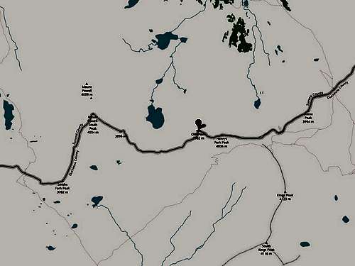
Cliff Point is located in the High Uintas Wilderness area of Utah. There is more than one trail which can be used to get within striking distance of Cliff Point (however, there is no trail which leads to the top of the Henrys Fork Massif upon which Cliff Point is located). By far the shortest approach is from the Henrys Fork Trailhead which originates nine miles (as the crow flies) north of Cliff Point. Be aware that parking is often full, especially during the summer/fall weekends as the Henrys Fork Trailhead is the most common starting point for the popular Kings Peak hike. Kings Peak at 13,528 feet is the tallest mountain in Utah.
An alternate starting point for Cliff Point, according to David Rose in his book "Utah Thirteeners", is the Yellowstone Creek Trail which originates at the Swift Creek Trailhead. This trailhead begins 13 miles (as the crow flies) to the south of Cliff Point.
For information on how to reach the Henrys Fork Trailhead or the Swift Creek Trailhead see the Trailheads Section of the Kings Peak page.
Anderson Pass Route
Kings Peak, Utah's tallest mountain (point B on the map below), and Cliff Point (point A on the map below) are separated by only one and a half straight line miles. Therefore, any approach route leading to Kings Peak also gets one within a hairsbreadth of Cliff Point. Consult the Approaches Section of the Kings Peak page for detailed information pertaining to the Henrys Fork Trail and/or the Yellowstone Creek Trail - both of which are mentioned above, in the Getting There section, as feasible staring points for Cliff Point.
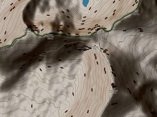
Upon following your trail of choice into the High Uintas Wilderness area, make your way to Anderson Pass (the highpoint of the Highline Trail). From Anderson Pass follow a bearing of 323 degrees for about 250 yards to the obvious, prominent, point known as Anderson Knob at 12,895 feet. Here is a map with Anderson Knob marked with a pin.
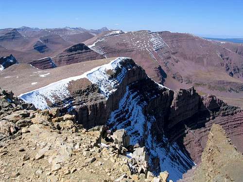
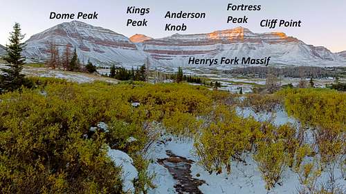
From Anderson Knob head due west along the crumbling, often exposed, ridge which connects with 13,260-foot-tall Henrys Fork Peak (aka Fortress Peak) located about three quarters of a mile away. Expect to do some class 3 scrambling. The exposure at times can be unnerving since parts of the ridge are as narrow as three feet with huge drop offs on either side. As you cross the ridge, the views in all directions are breathtaking - but especially so when looking down the north side's vertical plunge of 600 or more feet.
SummitPost member Scott Wesemann, in his Climber's Log entry for Henrys Fork Peak (aka Fortress Peak), states the follow about the ridge between Anderson Knob and Fortress Peak, "the ridge is phenomenal, one of the best I have been on." Similarly SummitPost member Pfeiffer75 in his Climber's Log entry For Henrys Fork Peak says "the exposure on the ridge leading from Anderson Knob to Henry's Fork Peak is impressive."
From Fortress Peak downclimb in a westerly direction, angling toward the left, less exposed side. Once off Fortress Peak the terrain will become easy class 1 walking over rocks and soil. Continue half a mile to Cliff Point.
Red Tape
A parking fee may be required at the Henrys Fork Trailhead.
When to Climb
July, August, and/or September. Expect many mosquitoes in July. After Labor Day, be prepared for snow, as well as freezing temperatures.
Camping
Dollar Lake, when coming from the Henrys Fork Trailhead, is the most popular camping spot – do not expect to be alone. If the crowds at Dollar Lake don't appeal to you, feel free to camp wherever you want. There are plenty of water sources in the High Unitas.
External Links
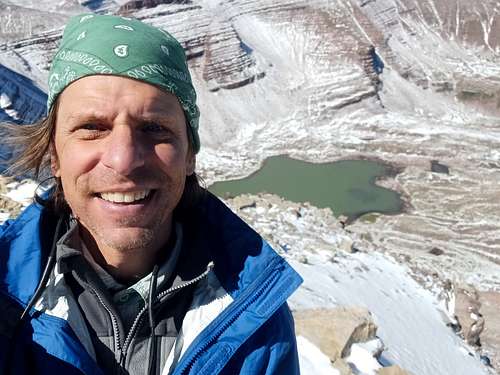
- See photos from my traverse of the Henrys Fork Massif September 23, 2023.
- Watch a YouTube video of my climb of Cliff Point September 23, 2023.