
-
 3138 Hits
-
 79.78% Score
-
 11 Votes
|
|
List |
|---|---|
|
|
Overview
The Aosta Valley (Italy) is one of the most famous and beautiful mountainous countries in the world. It holds many impressive mountains like Monte Bianco, Monte Rosa, Monte Cervino (Matterhorn) and Gran Paradiso. But there are also many 3.500 meters peaks which are well known all over the world: For example the impressive Aiguille Noire de Peuterey and almost as impressive; Herbetet, Aiguille de Trélatête, Grivola, Mont Vélan, Becca di Luseney and many others.
La Valle d'Aosta (Italia), è una delle più famose e belle regioni di montagna del mondo. Contiene molte montagne imponenti come il Monte Bianco, il Monte Rosa, il Monte Cervino (Matterhorn) e il Gran Paradiso. Esistono però anche moltissime vette di oltre 3.500 metri molto conosciute dagli alpinisti come l'imponente Aiguille Noire de Peuterey, l'Herbetet, l'Aiguille de Trélatête, la Grivola, il Mont Vélan, la Becca di Luseney e molte altre.
MAPS:
Valsavarenche Valley
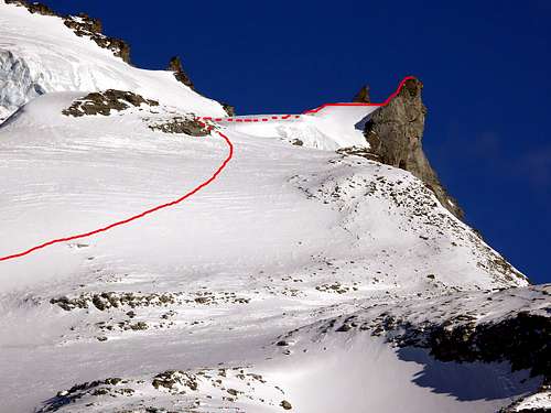
Becca di Moncorvè 3.875m First ascent normal route from Valsavarenche: Luigi Vaccarone, (Aug 12th, 1885).
Difficulty: F+/PD-.
Difference in height: About 1.915m.
Refuge: Vittorio Emanuele II, (2.732m). Places when open: 137. Winter hut: 21 places.
Ascent time: 5,00-5,30 hours.
Descent: Along the ascent route.
Equipment: High mountain equipment: including rope, ice axe, and crampons.
|
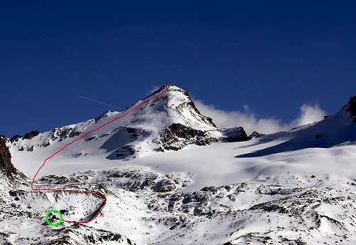
Tresenta 3.609m First ascent (NW Wall) from Valsavarenche: G. Bobba, C. Thérisod and G. Noro, (Sep 25th, 1894).
Difficulty: F.
Difference in height: About 1.650m.
Refuge: Vittorio Emanuele II, (2.732m). Places when open: 137. Winter hut: 21 places.
Ascent time: 4,30-5,30 hours.
Descent: Along the ascent route.
Equipment: High mountain equipment: including rope, ice axe, and crampons.
|
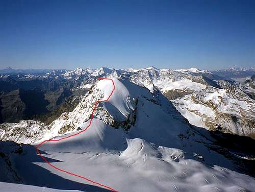
Ciarforon 3.642m First ascent (NE Arête) from Valsavarenche: F. Gonella, G. Blanc and F. Dayné, (Jul 29th, 1885).
Difficulty: PD+/AD-.
Difference in height: About 1.695m.
Refuge: Vittorio Emanuele II, (2.732m). Places when open: 137. Winter hut: 21 places.
Ascent time: 5,30-6,30 hours.
Descent: Along the ascent route.
Equipment: High mountain equipment: including rope, helmet, frontal torch, ice axe, and crampons.
|
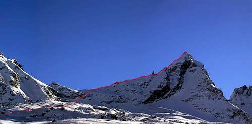
Becca di Monciair 3.544m First ascent (NE Arête) from Valsavarenche: G. Frasca and G. Blanchetti, (Jul 14th, 1881).
Difficulty: F+/PD-.
Difference in height: About 1.585m.
Refuge: Vittorio Emanuele II, (2.732m). Places when open: 137. Winter hut: 21 places.
Ascent time: 5,00-5,30 hours.
Descent: Along the ascent route.
Equipment: High mountain equipment: including rope, helmet, frontal torch, ice axe, and crampons.
|
Refuges Telephone Numbers
- Refuge Vittorio Emanuele (2.775 meters) +39-0165-95920
- Refuge Federico Chabod (2.750 meters) +39-0165-95574
Books and Maps
BOOKS:- "Guida dei Monti d'Italia-Gran Paradiso Parco Nazionale" E. Andreis, R. Chabod, M. C. Santis, Club Alpino Italiano/Touring Club Italiano, prima Ed. 1939; seconda Ed. 1963; terza Ed. 1980.
- "Guida delle Alpi Occidentali", di Giovanni Bobba e Luigi Vaccarone C.A.I. Sezione di Torino Volume II (parte II), 25 Maggio 1896.
- "Il Parco Nazionale del Gran Paradiso" di G. Berruto, volume 2° Ed. I.G.C. Torino 1981, 2000.
- "80 itinerari di Escursionismo Alpinismo e Sci Alpinismo in Valle d'Aosta", di Osvaldo Cardellina, Ed. Musumeci, Giugno 1977 (in Italian); seconda Ed. Luglio 1981; terza Ed. Luglio 1984; (in French), prima Ed. Febbraio 1978; seconda Ed. Marzo 1980.
- "Gran Paradiso" A. Gegenfurtner, G. Klotz, F. Müller, Ed. Bergverlag Rudolf Rother, Monaco 1980 (in tedesco).
- "Gran Paradiso" G. Klotz Ed. Bergverlag GmbH Rother, Monaco 2005 (in tedesco).
- "Rifugi e bivacchi in Valle d'Aosta", di Cosimo Zappelli aggiornata da Pietro Giglio, Musumeci Editore, Luglio 2002.
- "Diari Alpinistici" di Osvaldo Cardellina e Indice Generale accompagnato da Schedario Relazioni Ascensioni 1964-2019 (inediti).
 |
 |
 |
 |
 |
- Kompass "Gran Paradiso Valle d'Aosta" Sentieri e rifugi-Carta turistica 1:50.000.
- I.G.C. Istituto Geografico Centrale "Gran Paradiso La Grivola Cogne" Carta 1:25.000.
- I.G.C. Istituto Geografico Centrale "Il Parco Nazionale del Gran Paradiso" 1:50.000.
- I.G.M. Istituto Geografico Militare Foglio 41 "Gran Paradiso-Cogne" 1:25.000.
- AIAT Cogne "Gran Paradiso" Cogne Aymavilles-Walking map 1:25.000.
- Enrico Editore Ivrea "Gruppo del Gran Paradiso" 1:50.000.
- Studio F.M.B. Bologna "Gran Paradiso" 1:50.000.
- L'Escursionista "Valle di Cogne Carta dei Sentieri" (n° 10) 1:25.000.
- L'Escursionista "Tour de la Vallée de Cogne Grand Paradis" Carta dei sentieri 1:25.000.
Important Information
- REGIONE AUTONOMA VALLE D'AOSTA Official Site.
- FONDAZIONE MONTAGNA SICURA Villa Cameron, località Villard de la Palud n° 1 Courmayeur (AO) Tel: 39 0165 897602 - Fax: 39 0165 897647.
- SOCIETA' GUIDE DI COGNE Tel. 347/9473526 – 328/1373728.
- A.I.A.T. Cogne Gran Paradis via Bourgeois n° 34 Tel. 0165-74040.
- A.I.NE.VA.(Associazione Interregionale Neve e Valanghe).
- Ezio Sport articoli sportivi- via Bourgeois n° 64 Phone: 016574204.
- SOCIETA' GUIDE ALPINE DEL GRAN PARADISO Comune di Valsavarenche.
Useful Numbers
- Soccorso Alpino Cogne (SAR) Tel. 3482685406.
- Protezione Civile Valdostana località Aeroporto n° 7/A Saint Christophe (Ao) Tel. 0165-238222.
- Bollettino Meteo (weather info) Tel. 0165-44113.
- Unità Operativa di Soccorso Sanitario Tel. 118.