The US Highpointers Club works to help its members climb the 50 US state summits. Several members have completed this goal and are looking to climb the US territories and US commonwealths. For the Commonwealth of Northern Mariana Islands (CNMI) the highpoint is Agrihan at 3166 feet (965 meters). In 2015 a team of 6 climbers attempted to become the first to climb Agrihan and find the true highpoint. Although unsuccessful, the lessons learned were applied to a 2018 expedition.
To spread the cost of chartering the boat between Saipan and Agrihan we sent out emails and posted on SummitPost/Facebook trying to entice others to join the team. In the end we had a group of 12 climbers (which include five 50-completers): ChuckB, TonyC, PeterF, GingeF, JoshG, ConnorH, GregJ, ClintK, ReidL, JoeM, JohnM and GaryR. Most of the logistics was handled by KathyD. The team hired 6 locals to cut the trail and help porter supplies: FrankC, VincentF, InosG, JoeO, RayS and LawrenceT. Many other locals supported the team including the northern islands mayor's office, the villagers living on Agrihan and the Super Emerald's owners/crew. This trip report details the team's efforts to climb and find the true highpoint during May 26 - June 6, 2018. It turned out to be a first ascent (FA) of Agrihan!
[Photos: while I haven't given individual photo credits, I want to thank all those team members who have shared their photos.]
Preparation
In recent years there have been three "lunatics" behind the expeditions to climb Agrihan: RogerK, ClintK and JohnM. Beginning in the Fall of 2016, these three started talking about trying Agrihan again. Being members of the 2015 expedition, they looked at it for learning lessons. In broad strokes, there were logistical problems and technical problems which prevented the 2015 team from being successful. Each identified problem was analyzed and possible solutions brain-stormed and researched. This on-again, off-again research went on for months. An example logistical problem was that the 2015 cutters didn't bring enough food for 10 days. Possible solutions were to pre-pay some wages so they can buy their food or the team buying additional food for them. An example technical problem was how to climb very steep, slippery vegetated slopes. Possible solutions were microspikes, long screw drivers or ice axes.
In 2015, the team relied on various topo maps which indicated the highpoint being either the western summit or the eastern summit (both along the southern crater rim), with a slight majority leaning towards the western summit. In the Spring of 2017, RogerK discovered new DigitalGlobal data which indicated the eastern summit is higher. JohnM was able to enlist Andrew Kirmse and Andy Hatzos to perform SRTM data analysis (no LIDAR data exists) of the southern rim of Agrihan. Andy identified four potential peaks - P945 (the western summit) and a trio of peaks (P947, P952 and P960) for the eastern summit. With the 2018 objective being the eastern summit, a complete rethink of the route was needed. ClintK examined several sources of satellite imagery and identified possible routes (Rx) and possible difficulty areas (Dx). It was quickly obvious that landing at a small southeast beach (site of a long abandoned settlement) would be advantageous - saving the team 1+ days of trail cutting.
In late Spring 2017 we finally felt confident enough in our solutions that we started asking around to form an expedition. Unfortunately, most climbers were already committed to other adventures ;( By July, 2017, it was only three people. It was decided it would be too expensive and too risky to mount a successful expedition. The expedition would be postponed until 2018. Starting in December, 2017, and becoming earnest by February, 2018, JohnM beat the bushes to find climbers interested in joining the team. The vast majority of the team was signed up by April, 2018, although we had one spot filled just 1 week before the expedition left!
In parallel, KathyD and JohnM worked the logistics side of the expedition. Please read the "Preparation" section of the "Agrihan 2015" trip report for details since not much has changed. KathyD worked with the northern islands mayor's office (NIMO) to fill out and sign permits. She also worked with the owners of the Super Emerald to charter the boat for a "stranding" expedition. In 2015, the team chartered the boat for 10 days with the boat remaining at anchor at Agrihan. Due to cost increases, this was no longer viable. Instead the team went for the "stranding" option where the boat drops the team off at Agrihan and returns to Saipan. Thirteen days later (with an early return option) the Super Emerald would return and pick the team up from Agrihan. The significant risks being weather (an early typhoon) and accidents requiring medical evacuation. The later was slightly mitigated by having team members with wilderness first-aid and medical doctor skills. The team rented a satellite phone for emergencies and one member brought a new Garmin Explorer with global texting capabilities for communication.
An online spreadsheet was created listing every item in the "kitchen sink" of gear needed. This ranged from the mundane/obvious like leather gloves to the crazy like a grappling hook or hammer drill. By mid-April, team members were identifying what gear they had available and by mid-May gear assignments were made. Calls were made to Saipan to verify certain gear could be bought there. Team members started leaving for Saipan by May 20th. Although several members had issues with flights and baggage handling, everyone and almost everything was secured before the Super Emerald left the dock on May 26th.
Note: this year most team members wanted to cook meals. An attempt was made to ship MSR/Primus-style isopro canisters to Saipan 6 weeks in advance, but they didn't arrive in time; they arrived after we returned from Agrihan. Surface USmail takes a long time - at least 2 months. We found Coleman white gas (1 gallon containers) at the ACE Hardware which we used with MSR Whisperlite stoves. Also at ACE Hardware, we bought butane camp stoves (example) which use the butane cylinders (example) to use at base camp.
May 23-25, 2018 - Saipan - Preparation
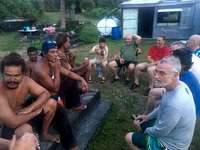
As team members stream into Saipan, three key meetings were held. One meeting was held with the boat owner and boat captain along with the lead local cutter "Jungle" JoeO. We indicated that we would prefer a southeast beach landing but the boat captain was uncertain. It would depend on sea conditions. We will at least approach Agrihan from the south so we can view the eastern summits in detail. We also explained to JoeO that we will be taking a different route this year, but follow the same general siege strategy of establishing camps and hauling water/gear higher up the mountain each day. Almost everyone was able to attend the meeting with CNMI Governor Ralph Torres where we learned about the importance of the northern islands in general. Soon after we met with northern islands Mayor Vincente Santos and his team. Our team learned more about the history of Agrihan and its current developments. Everyone signed the MAE and final arrangements were made.
Several shopping trips were made to ACE Hardware for gear and Joeten Supermarket for food/water. Working with the boat owner we were able to buy 250 gallons of water (roughly 1.5 gallons per person per day for 13 days) and have it delivered to the dock - thus saving us a lot of work hauling water.
Two team meetings were held. KKMP radio station owners Gary and Rosemond Sword hosted a social dinner for the team. This was the first chance for everyone to meet each other in person. The second meeting was held by JohnM where he showed the team various maps and described the Day 1 plan of action and the general plan for future days - all subject to change at an instant. Co-leaders JohnM and ClintK were fairly confident that we could establish a High Camp by day 5 or 6. The real challenge would be finding a route through the upper stretches to the crater rim. This area is very serrated and ridges can be unexpectedly broken as they discovered in 2015. We wanted a full week to give us time to find the route, even if that meant back-tracking below High Camp and trying again. Given the heat and humidity and its resultant high water consumption, the plan was to have most of the team stay at Base Camp. Daily trips would haul gear/water uphill and stock the High Camp for several days. On a rotating basis, some team members would stay high with the local cutters to help establish camps and make sure the route was progressing on the right track. Loading the boat with 13 days worth of food, water and gear for 18 people was our last challenge.
May 26, 2018 - Saipan to Agrihan
We were told to rally at the dock by 8:00AM for a 9:00AM departure time. Several car shuttles are required to get all 12 climbers there in time. The tricky task is returning the rental car in downtown Garapan and hitch-hiking back to the dock. The local support team arrives around 8:30AM ready to go. Once aboard we notice none of the gear/water has been tied down. Captain Fred announces we will have calm seas and there is no need for tying down. It turns out to be bathtub calm :-) Everyone is top-side as we depart Saipan for our 24 hour ride to Agrihan. It's a partial relief for ClintK and JohnM - no more "should we bring xxx?", we'll McGyver it with whatever we have.
Team members nap, talk, enjoy the sun/sea and generally relax. There is no cooking while the boat is in motion. The boat crew trawl for fish and we do have fresh sashimi - JoshG comments "You know the sashimi is fresh when it's still warm." In the evening while enjoying a nice sunset we have SPAM and beans over rice and some fish head soup. During the night most people sleep inside - enjoying the last air conditioning for two weeks.
May 27, 2018 - Agrihan - establishing Base Camp and initial forays
The natives are restless; people start stirring around 5:30AM for sunrise. Most everyone is awake around 7:00AM when Agrihan is barely visible on the horizon. We dodge rain squalls but none of the rainbows point to the summit of Agrihan ;( By 8:30AM we are cruising from the southern point towards the southwest beach. Everyone is on deck checking out the upper slopes hoping to identify the highpoint and ridges to follow. Unfortunately the crater rim is mostly shrouded in clouds although we get a few breaks.
We anchor at 9:00AM and hoist the dinghy into the water. Over the next two hours we make 6+ trips off-loading 18 people and all the supplies for two weeks. We are also bringing some supplies and a new generator for the two villagers living on Agrihan. The first two trips include the local cutters and GingeF, JoeM, JohnM, GaryR. Their task is to strike out with day packs and start establishing a trail through the lower 1/4 of Agrihan which is mostly coconut palm forest. Their progress is slow due to branches and having to walk on a sea of coconuts. The idea is to stay near the main ravine, perhaps breaking out on the true left if the ravine is too steep/cluttered. They make it about half-way up by 14:30PM at which point most other team members have caught up. We establish a water cache here and all return to Base Camp. On the way back we re-route the trail to eliminate zig-zags and follow the old trail from the 2015 expedition.
Meanwhile the rest of the team meet the two villagers - JeremyT and EddieS. They have an ATV with a trailer and help us cart our supplies up to the village. They and the mayor's office have given us permission to use the old dispensary building and its surrounds as a Base Camp. A couple of people sleep inside the building, but most setup tents or hammocks outside. After members settle in and have lunch, small groups load their packs with gallon jugs of water and follow the pink blazes through the forest. They eventually catch-up with the lead team who left around 10:30AM. We collectively drop our water (roughly 20 gallons) and return to the village to relax and explore. For the lead team, they had time to establish their camps in the afternoon. ClintK and JohnM (2015 team members) are shocked at the state of the village. Back in 2015 it was covered in forest. Today it is cleared with grass/flowers around and nice amenities like pit toilets, a rain basin for showers. and radio communication back to Saipan.
ClintK is slightly disappointed at yesterday's progress and along with GingeF and JohshG leave camp with gallons of water and flagging tape at 6:00AM. They quickly reach yesterday's highpoint and start blazing the trail upward. As other team members finish breakfast they also follow with water and gear - namely hand saws. Around 7:30AM-8:00AM the local cutters have caught up. We explore the option of returning to the ravine, but decide to continue up through the forest instead. With the cutters leading, we continue up for another hour before reaching sword grass. ReidL explores the sword grass and thinks it will go. "Jungle" JoeO wants to traverse left back to the main ravine and try taking that up instead. We explore this option but after 30 minutes decide it is futile. We're losing time and would need to re-route a significant portion of the trail down below. Unfortunately there is a slow trickle of climbers coming up this side-track. We should have had a "pause" signal on the main trail so people don't waste effort. We have several FRS radios, but decided on 4-hour interval radio calls instead of keeping them constantly on. At least everyone gets to experience the frustration of exploring and back-tracking like the lead team did yesterday.
So it's off to the wild green yonder of sword grass ;( We've made good progress this morning by reaching the forest/swordgrass transition at 10:30AM. At this point the cutting team slowly heads off into the 6-7 feet (2 meters) tall swordgrass. They will cut from isolated tree to isolated tree on their way up to the ridge line. Trees mean shade which makes for good break stops - especially in the sun, heat and humidity of Agrihan. Trees also make for nice "executive offices". Usually Jungle JoeO would direct the other cutters by shouting directions from the branches of these trees. Being above the sword grass you can see where the trail should go, versus being in the sword grass where it is easy to wander.
While the cutters head off, the climbers have various tasks in the forest. For example, GaryR and ChuckB become saw men - cutting branches back for the passage of large, heavily-laden backpacks. It's fortunate that GaryR is tall so even high branches are cut; this way other height-challenged members don't have duck all the time. Others like PeterF and JohnM re-flag sections and clean the trail of coconuts. Still others shuttle water from yesterday's cache up to the transition area. Most members didn't bring lunch so they return to the village by mid-afternoon. Even with the forest shade, it's hot, miserable work. The resulting trail is beautiful though ;) People will appreciate it in the coming days.
A few of us venture into the sword grass. In a word - MISERABLE ;( For newbies, you'll find it quickly draining - especially in the afternoons. ClintK reaches the cutters around 14:00PM as they reach the top of the ridge. After resting, JoeO and ClintK climb the shade tree and discuss the route. After some back-n-forth both men are agreed on the route. It helps to have a compass, GPS and stored satellite imagery on a smartphone. The cutters proceed and establish Camp 1 around 15:30PM. They are waiting for the local porters to bring all the supplies up from the beach.
In the early-evening, rumors are floating that there is a cliff ahead. TonyC runs up to Camp 1 with his drone and doesn't see any issues. Fingers crossed for easy trail tomorrow. GingeF and JoshG decide to enjoy the cooler weather at Camp 1 (1000 feet) and spend the night there.
Team members start waking up around 5:00-5:30AM. Most will cook a proper breakfast while others eat GORP before heading out. The tasks for today - haul water (of course), setup at least one rain water catchment system and clean the trail through the sword grass. Being anxious about this potential "cliff", ClintK heads out early. He is shocked to see JoeO and several cutters camped at the forest/swordgrass transition. Apparently the porters couldn't bring up all the camping gear so the cutters had to retreat from Camp 1. This is bad news ;( Hopefully it doesn't happen again.
GingeF has already been hauling loads from the tree-line to Camp 1 and is soon joined by other team members. Most will drop their loads at Camp 1, while a few will continue carrying to the "head" of the trail where the cutters are before dropping their loads on the trail. By 10:30AM it's obvious there is no "cliff". It turns out to be a minor dip as we contour around the top of the major ravine we've been paralleling yesterday. Around noon we are through most of the heavy/thick swordgrass. The trail cuts straight up through waist-high ferns (a slow, sweaty climb when it's sunny) and then contours around to a saddle. At 13:00PM, ClintK makes a radio call asking JohnM to drop his gear and come up quickly. We are making very good progress (thanks to the ferns) and rapidly approaching our first major milestone - the D1 difficulty area. The cutters continue until around 14:00PM when it starts to rain. A perfect time to rest since it's too dangerous to swing machetes in the rain. Shortly later JohnM appears - completely exhausted.
After the rain stops, the cutters and ClintK proceed to the saddle. It offers a perfect view of the D1 difficulty area ;) Being mostly cloudy it's hard to tell how the route will proceed through the ravines. Spots of sunlight help highlight various dips and ridges which help. It's obvious it will take some time to negotiate this region. The cutters call it quits for the day at 15:00PM and establish Camp 2 (elevation 1550 feet/472 meters) here. They are waiting for the porters to bring all the gear up. JohnM will join them tonight and help with route finding tomorrow.
Meanwhile, TonyC has been busy at Camp 1. He has manufactured some tarps which can be staked above the ground and funnel rain water into buckets. Those buckets can then be filtered to provide clean drinking water at these camps. The hope is it rains enough we don't need to haul 100+ gallons of water up the mountain. Likewise GregJ is catching rainwater from the building's gutter which can be filtered as well. We seem to be going through water at a faster than expected pace (5L per person per day). Fortunately we budgeted extra water to be used by the cutters - and the climbers if needed.
May 30, 2018 - Agrihan - passing through D1 and establishing Camp 3
The morning radio call is exciting. TonyC collected and filtered 7 gallons of rain water last night! This is great news - 56 pounds less that needs to be hauled uphill ;) Today's tasks are: haul water (of course), bring up all the rainwater catchment systems, cut stakes from the rainwater tarps, bring food/gear for TonyC and JohnM since they are staying high, bring sweaters for the locals and start hauling some climbing gear (rope, anchors) in anticipation of establishing a high camp soon. With so many tasks, everyone is busy. ClintK is tasked with cutting 3 foot (1 meter) poles for the rainwater tarps. Hauling these up through the sword grass turns out to be murderous. JohnM is very glad to receive his food/gear as well as TonyC. As we climb higher the night-time temperatures drop from the low-80s to the low-70s. In combination with windy camp sites, the cutters are glad to wear the sweaters we provide them.
In the morning TonyC left Camp 1 for Camp 2 and setup a rainwater catchment system there. Meanwhile the cutters proceeded ahead, scouting out a path through the D1 ravine complex. After a couple of attempts they found a 40-50 foot (12-15 meter) descent that was safe enough to reach the bottom of the ravine. By noon they were through the ravine complex and having lunch on the other side. [Sorry, I wasn't at the head so I can't give details as to what happened]. After lunch the cutters head east to avoid sword grass. They then turn north and head up mostly through ferns. They will establish Camp 3 about half-way up this nearly 1 mile (1.6km) long ridge. At this turn, TonyC sets up another rainwater catchment system by 14:00PM and will dub it Camp 2.5 since he'll sleep under the rainwater tarp.
Several team members, including the "young kids", proceed from Camp 2 to check out the D1 ravine complex. They are all suitable impressed by the descent. Everyone agrees that it would be good to set a fixed rope here to use as a hand line for safety.
Back at Camp 2, co-leaders JohnM and ClintK discuss logistics. These same topics will be discussed by ClintK and the rest of the team down at Base Camp tonight. We will establish High Camp (Camp 4) tomorrow below the D5 difficulty area. The easy question is what climbing gear should people bring to High Camp. It's still unknown what problems we will encounter up ahead; remember this is a first ascent so there is no beta for the route. We decide to start light with ropes, snow pickets and bed-frame angle iron for anchors (we already have rebar at Camp 2) along with a hammer and a range of slings/bits-of-rope for tie-offs. We'll leave the technical/alpine gear at Base Camp for now. For personal gear, everyone should bring their harness setup (including rappel device and prussik knot). We debate about jumars/ascenders but ultimately decide to leave them as well. Some members bring microspikes for the slippery vegetation.
The much harder question is when should the team leave Base Camp and populate the higher camps? The key concern is having enough water at High Camp to support the team for awhile. We have about 30 gallons of water at Camp 1, 6 gallons of water at Camp 2, but hardly any water at Camp 3 or above. Compounding this, yesterday's rains appear to have moved off so we likely won't collect more water ;( The debate swings back-n-forth with the final decision to wait for the radio call tomorrow morning. If it rains tonight, the team will move to High Camp tomorrow. Otherwise tomorrow with be a water/gear hauling day to supply High Camp.
May 31, 2018 - Agrihan - reaching High Camp and exploring above
The 5:00AM radio call is discouraging - no rain ;( This means today will be a water and gear hauling day to stock High Camp; tomorrow the team will move from Base Camp to High Camp. PeterF, ClintK and ReidL leave by 5:30AM with the other team members following. The incentive is to reach Camp 2 before the sun gets high and starts roasting you in the sword grass. A radio call from Camp 2 has TonyC asking whether we go left or right. He provides GPS coordinates which are way off, but ClintK advises keeping left. Lesson learned - while we have maps with UTM grids overlaid, apparently TonyC didn't have a copy.
Traversing the D1 ravine complex is a little tricky with heavy backpacks, but doable. JohnM has set one line and JoshG and ClintK will set other hand lines (snow picket or tied-off bollard of sword grass as anchor) in the early afternoon. Once past, you quickly reach Camp 2.5 which is just a rainwater tarp. Heading uphill (north) through knee-to-waist high ferns we eventually reach Camp 3 where the local cutters stayed last night. Pushing upwards it's another hour to Camp 4 - this time mostly through ferns but there is some sword grass. We reach Camp 4 (aka, High Camp) at an elevation of 2550 feet (777 meters) around 11:00AM. TonyC, GingeF and JohnM are just finishing the installation of another rainwater tarp. They are happy to see us - more specifically the food and water we're hauling. Aside: several team members figure their raw SPAM limit is half a can (6 oz) before the gag reflex kicks in.
High Camp is in a perfect location to view the D5 difficulty area - which appears to be a non-issue with only minor ravines. When the clouds lift we have a great view of the upper mountain and the crater rim. The question becomes, "Will it go?" In the afternoon GingeF, ReidL and JohnM follow the cutters as they progress through the D5 and D6 difficulty areas. Passing through these minor ravines involves a drop of 10-20 feet (3-6 meters) into the ravine, following the ravine (usually downhill) for a short distance (100 feet/30 meters) and then climbing 10-20 feet out of the ravine. Once past D6 you climb onto a nice shallow ridge for some 700 feet (210 meter) ranging from 2700 to 2800 feet elevation. It appears this would be a nice landing area for helicopters. The main concern would be horizontal and vertical visibility rules since Agrihan is typically shrouded in clouds. At the top of this ridge is where the cutters established their high camp. With only knee-high vegetation and shrubs, they had a miserably cold night (high-50s to low-60s?) on this windy exposed ridge.
Meanwhile, team members were continuing to bring their loads of gear/water to Camp 3 or Camp 4. By the evening we had 10 gallons at Camp 4, 6 gallons at Camp 2 and 20+ gallons at Camp 1 with most of the heavy climbing gear at Camp 4. GingeF, ReidL and JohnM stay at Camp 4. Early tomorrow they will climb to the crater rim and evaluate whether P960 is the true highpoint or not. ChuckB and JoshG will stay at Camp 2 and JoeM will stay at Camp 1 to collect rainwater tonight.
June 1, 2018 - Agrihan - moving to High Camp and exploring crater rim traverse
It's U-haul (as in "you") moving day for most of the team today! People pack their personal mementos, climbing gear, food and water and hike up to Camp 4 (High Camp). Most people plan for just one night at High Camp, while others prepare for multiple nights at High Camp. Either "just in case" the route is bad or because they want to spend time near the summit to really savor it. It's about 4-5 hours from Base Camp to High Camp, so most team members arrive at High Camp between 10AM and 12PM. Note: if you have slow moving people on your team, you may consider breaking their ascent into two days with a stay at Camp 2. Between Camp 2 and Camp 3 the ascending climbers cross paths with the descending local cutters. While they didn't reach P960, they got close enough to see into the crater - an awe inspiring sight for many. Several climbers ask them to return to join us on the summit, but the locals say "No thanks, it's for you." They had a miserable night and want to return to the beach to get warm, clean and eat freshly roasted pig.
In the morning GngeF and JohnM left High Camp and joined the cutters at their high camp. One last ravine traversal leads them onto the main ridge leading to P960. This ridge narrows (1-2 feet) at places and you pass over humps along the ridge. This leads to naming it Stegosaurus Ridge. Right before the crater rim there is a small patch of "cloud forest" trees covered in mosses. You can literally wring the water out of the mosses and drink it! Great care is taken as GingeF and JohnM approach P960. They want to get close to the summit without actually touching the summit. That will wait until tomorrow so the entire team can summit at the same time. This will be a first ascent after all. They find a spot below the summit and JohnM starts the task of finding the true highpoint. He uses a combination of PeakPal app, a 5x hand level and a Sokkia B24 survey level. This is harder than expected because the clouds lift for only short periods of time.
Around 12:30PM JohnM radios down to Camp 4. "It appears that P952 is higher than P960, but I'm well below the summit of P960. Can I go to the summit to make more accurate measurements?" [paraphrased] Some team members say they are too tired to summit today, so that isn't an option. The crisis is averted when GaryR finds a higher spot near the summit without being on the summit. Whew! GingeF's reaction to this news is "Thank you for extending the moment". He sets off with PeterF and GaryR to explore a crater rim traverse to P952. [Sorry, I wasn't there to witness the initial crater rim traverse so I can't provide more details. See the June 2 entry for details about the traverse as it was secured on summit day].
The next couple of hours sees a flurry of activity. ClintK is asked to descend to the D1 ravine area to pull all the hand lines/ropes and anchors; fortunately he doesn't have to return to Base Camp for even more gear. There's a request to send up what anchors exist at High Camp already. Another request for medical tape is concerning but turns out to be used to secure the hammer in case it slips.
By 17:30PM team members are returning from the crater rim with news. GingeF returns soaked and covered in mud. He led the "pitches" (Class 4 sections) of the crater rim traverse. One section was especially hard with lots of dirt and vegetation pulling out on him. JohnM says the levels indicate P952 is 5-10 feet higher than P960, although no back-sighting has been done to confirm this. ReidL used a barometric pressure app on his iPhone which indicates P952 is higher than P960. It's almost certain P952 is the true highpoint. Hopefully over the next couple of days it can be confirmed. Most people will summit both peaks just to be safe. Although ... ReidL's description of the traverse is quite scary. There are thin ridges with steep drop-offs on both sides. Some of the descents/ascents are mud-fest ordeals. The dangers of the traverse are not to be taken lightly. Fortunately, GingeF will secure the traverse with the ropes/anchors retrieved from the D1 ravine complex.
June 2, 2018 - Agrihan - Summit Day and a First Ascent!
Wakey, wakey, it's Summit Day! While more than half the team has already been to the crater rim, for the rest of us it is an exciting day. Not an alpine start, we leave High Camp around 6:45AM, hiking through dense mist/clouds. Passing through the D5 and D6 ravines is a little muddy but easy enough. The gloomy mist lends an air of mystery to the ascent, especially once we reach the final ridge. A hump slowly appears in the distance. Is that P960? As we climb over the hump you realize - No. Maybe the next hump? These humps dub this final ridge Stegosaurus Ridge. We are fortunate to have light winds. If you have strong and/or gusty winds (as experienced in 2015) getting over these humps might be more "exciting" ;) Shortly before 8:00AM we finally crest onto P960!
Although we are almost certain P960 is not the true highpoint, celebrations break out. The fact that we reached the crater rim is an achievement in itself. Flags, banners and other mementos appear with lots of photos being taken. ReidL brought up a bottle of Scotch whiskey and passes it around as the celebratory drink. JohnM breaks out the satellite phone and calls KathyD - the 13th person on the team handling logistics back home. "We made it! ... Can you ask the Super Emerald to pick us up on June 6?" JohnM and ClintK call RogerK (team member on the 2014 and 2015 expeditions) but get voicemail instead. TonyC's Garmin Explorer is getting hot with all the text messages going out.
Over the next two hours small groups of people make their way across to P952. GingeF leads the way so he can secure the route with additional fixed ropes (used as hand lines) and additional anchors. While the team wanted to "ascend together" for P960, there wasn't that same feeling for P952 - the true highpoint. Although this would have been hard given the small size of the P952's summit area. As they return to P960 they sign the summit register that ClintK almost forgot to bring out. ReidL becomes the first 50+6 completer (50 US States + 50 US "Territories" [DC, AS, GU, MP, PR, VI]). For most team members it is their first "First Ascent". Unfortunately, two team members decide not to try the crater rim traverse. Can we prove it's a first ascent? No. But we've done lots of internet research and talked with several multi-generational locals and found no evidence of a previous ascent. We can definitely call it a First Recorded/Known Ascent.
I/ClintK found the 550-600 foot (170-180 meter) crater rim traverse from P960 to P952 far less scary than expected based upon ReidL's description, although I firmly believe it should be secured with ropes for safety (thanks GingeF). Most of the traverse is no worse than the approach on Stegosaurus Ridge. It's narrow at spots (1.5-2 feet) but there are also patches of cloud forest we crawl through. After ~250 feet the crater rim "breaks" leaving a 20-30 foot cliff. A rope is secured to a large bollard of low vegetation (at most knee-high) and backed up with a snow picket. You descend 10-15 feet off the side of the ridge onto a narrow ledge which you follow for 15 feet. Then it's another 10-15 foot drop to the base of the ridge. The hand line is very useful - especially when ascending since there is very little in terms of sturdy vegetation to grab hold of on the sides of the ridge.
You proceed another ~150-200 feet along this lower crater rim before coming to the critical section. The crater rim suddenly ascends back to its original height at a cliff. Fortunately, there is a side ridge which joins us from the south. We traverse left/south along the base of this ridge to the base of a 30 foot caving ladder. The 20-25 foot ascent up the caving ladder is easier than using jumars/ascenders. There are two bomb-proof anchors on top of the ridge (a 3 foot snow picket and a 2 foot bed-frame angle iron) which we left - because ClintK couldn't pull them out. For those of you leading this section, you will likely traverse an additional 60 feet left/south along the base before angling up toward a very small notch in the ridge. Once on top of this broad south ridge, it's an easy walk back to the anchors. Note, for a sense of scale see the above medium-sized traverse photo; on the left edge is the ladder and 2 climbers.
From the top of the ladder you'll follow the original crater rim another ~100-150 feet before reaching a small notch. At the base of the notch is the final 50-60 foot ascent to P952. This is quite narrow (1-1.5 feet) with extremely steep sides on both sides. Not a place you want to slip and fall - especially on the inside crater side. GingeF secured a true fixed line here. People tied in with a prussik knot for safety for the lower 2/3rds of the ascent where you pass an anchor. You can or cannot retie-in after the anchor for the last 1/3rd of the ascent; it's broad enough (relatively speaking). Congratulations, you've reached the true highpoint of Agrihan at 3204 feet (977 meters)! For this team there is also the extra satisfaction of being a first ascent. For me/ClintK, it's a great relief to finally make it, although I'm the last person to do it. After all the time, money, planning and logistics, the third time's the charm :-)
We spend time on P952 savoring the summit and the whole adventure/experience. Regrettably, the clouds are thick so there are no views ;( GingeF hammers his ice axe into the summit as a fitting end to this adventure. Who would have thought so much snow gear would have been used to climb a tropical volcano?!? Around 11:45AM the clouds suddenly lift. The whole crater is open. It's a real "Jurrassic Park" experience! Seeing a football field sized fumarole with its smoke dancing in the breeze. Watching birds - pterodactyls? - gliding on thermals. Twenty minutes later it's socked in with gray clouds again. By 14:00PM most climbers have started to descend. TonyC, ClintK and GaryR will stay at High Camp, GregJ rests at Camp 2 while the rest head to Base Camp.
June 3-5, 2018 - Agrihan - verifying true highpoint and village life
Up on the mountain, GaryR spends the next few days using the Sokkia B24 survey level to verify that P952 was the true highpoint. One day sighting from P960 to P952 and another day back-sighting from P952 to P960. This involved a LOT of patience since the clouds rarely lifted to get a clear shot between peaks. This gave GaryR lots of time to examine all sorts of strange bugs. Of note, the gnats/flies at the crater rim walk more than fly; perhaps an evolutionary adaptation to the higher winds? The results are: P952 is the true highpoint at 3204 feet, while P947 is 2-3 feet shorter (3201 feet?) and P960 is 5-7 feet shorter (3198 feet). JohnM had verified that P945 is some 40-50 feet shorter (3166 feet?) and the rest of the crater rim isn't even close.
TonyC, ClintK, JoeM and GaryR walked west (~250-300 feet?) along the crater rim from P952 to P947. It's quite doable being 2-4 feet wide. At P947 (nondescript) the crater rim falls away at a 25-30 foot cliff before continuing on. Quite similar to the break/cliff you encounter between P952 and P960.
On June 5th, ReidL and PeterF climbed from Base Camp to P952 where they met ClintK and GaryR. Thus the current sea-to-summit speed record is 3:30 - 4:00 hours. Another first, GaryR slept (tied into the anchor) on top of P952. We pulled the ropes, anchors and caving ladder, leaving only the two anchors at the top of the ladder section. JoshG then joined us and helped pull everything off the mountain. Other team members came up and helped clear Camp 2 and Camp 1. With some effort, TonyC was able to convince the local cutters to carry down there garbage (not the situation on previous expeditions). We left 2 gallons of water at High Camp and 7-10 gallons of water at Camp 1.
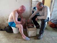
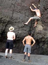
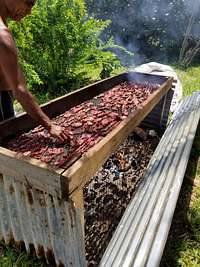
Meanwhile back at the village, Life Is Good! A chance to rest, relax, read, chat, play backgammon, wander the beach/village, go bouldering, search for benchmarks, ... A dwindling number of climbers went swimming in the ocean as the shark activity increased. The locals go spear-fishing quite often which attracts the sharks. Wading off the beach should be fine. The local villagers and cutters shared their food with the team. Such delicacies as fried bananas, freshly grilled fish and smoked pork. All washed down with celebratory beer/wine/Scotch/water ;)
Unfortunately, the expedition was not accident free. On the descent, not 5 minutes from Base Camp, GingeF slipped and cut his fingers/tendons with his machete ;( Fortunately ChuckB has wilderness first-aid experience and GregJ is a medical doctor. They were able to clean the wounds and suture them close by headlight. GingeF had successful surgery back home a few days later. You will likely end up with some sword grass cuts on your arms/legs and perhaps a few gouges due to the punji sticks from cut sword grass. These should be kept clean or you may encounter serious infections which last for weeks.
It's coming, it's coming ... sometime ... hopefully. Even though we summitted early, June 6th was the earliest the Super Emerald could come to pick us up. Based on past transit times, we were expecting the boat around noon. The hope was we could leave early enough that we could stop at Pagan for awhile. Meet the villagers and see some of the WWII artefacts. By late afternoon we were taking bets on when the boat would arrive. GingeF won at 17:00PM. The team rushed down to the beach as the dinghy was lowered. Several trips were needed to transport all the gear/people. Fortunately we had far less gear - leaving some 70+ gallons of water at the village. The seas were rough which slowed the unloading and loading times. One rogue wave almost capsized the fully-loaded dinghy at the shore.
We bid farewell to Agrihan around 18:00PM. On the upper deck we held a meeting and paid the local cutters for their hard work. Some of us tried eating, but it didn't go well. A few members got seasick. The seas were heavy (10-15 foot waves), but not body-slamming hard as in 2015. Still, far more people slept on the interior floor than on bunks. About 4 hours from Saipan we were ordered to go around a convoy of ships which added another hour to the journey. At least the seas were calming and you could enjoy the ride again. All hands were on deck as we approached the dock around 19:00PM. The boat owner met us with pizza and beer - and our spare luggage. Truck shuttles were arranged back to the hotel where people dived for the showers. There was also a mad scramble to re-book flights. We came back 4 days early and many wanted to fly to Guam and climb Mount Lamlam - the highpoint of Guam (another US territory).
June 8-10, 2018 - Agrihan to Saipan
The media started swarming after we returned. KSPN2 did two TV interviews on Friday and KKMP did a radio interview with us on Saturday. Some of the local cutters hosted the remaining team members with a Chamorro-style lunch feast at a local park. It was nice to sit, chat, meet family members, and the food - INCREDIBLE. A very enjoyable party. Even though we were stuffed, we managed to have a farewell team dinner that night.
While waiting for planes to leave, team members went sight-seeing, scuba diving and visted Tinian.
Essential Gear
Sufficient food and water (especially important due to the heat and humidity) is needed for all team members. You may consider bringing supplemental food and water for any locals you hire since they tend to underestimate their needs.
You may want to secure the Class 4 crater rim traverse using:
full-length climbing ropes
snow pickets or lightweight angle iron to drive 1.5-2 feet into the soil/pumice-gravel as anchors
lightweight (3-4 pounds/2 kg) sledge hammer
caving ladder or jumars/ascenders
The ropes are also useful as hand lines through the D1 ravine complex - especially when carrying heavy packs/supplies.
Dangers
The lower slopes have been taken over by feral pigs which were abandoned in 1990 when the local villagers were evacuated due to increased volcanic activity. There are a few feral dogs as well. Monitor lizards can also be seen on the lower slopes.
Your sanity is in danger due to the millions of gnats which infest the entire island, even the upper slopes near the summit. They are non-biting but a great nuisance until sundown when they disappear.
Using a machete to cut the sword grass leaves many punji sticks which can be painful You may want to wear tight-weave socks (for the punji sticks) and leather gloves (for the leaves) to protect yourself.
Open wounds can quickly become infected (any combination of bacterial, viral or fungal) which may lead to extensive treatment and recovery times when you return home.
External Links
KSPN2 TV interview with team after meeting the governor (May 25, 2018) - https://vimeo.com/271823719 [14:36 - 19:55]
KSPN2 TV interview with several team members after returning (June 8, 2018) - https://vimeo.com/274039834 [12:08 - 14:25]
KSPN2 TV interview with co-leaders JohnM and ClintK after returning (June 12, 2018) - https://vimeo.com/274639308 [14:49 - 19:03]
Clint and Tony (two members from the 2018 team) are planning a return trip in the mid-May to end-June, 2019 time frame. Most likely a 2 week trip (1 week on Agrihan). If interested, PM me or send email to clintkaul at gmail dot com.
A truly great trip report. Very well written and detailed. Most importantly, a great adventure born of the true spirit of exploration (forgoing far too common altitude and famous destination goals). I wish I had been part of the team. Keep up the inspirational work. I'm rooting for you all.
Parents refers to a larger category under which an object falls. For example, theAconcagua mountain page has the 'Aconcagua Group' and the 'Seven Summits' asparents and is a parent itself to many routes, photos, and Trip Reports.


 high down low")


 to Camp 1")


 has been hauling gear/water to Camp 1")


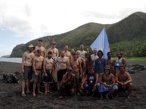
![P960: [back] GaryR, ReidL, GingeF, ClintK, JohnM, [next] JoeM, JoshG, [next] ChuckB, GregJ, PeterF, ConnorH, [front] TonyC](https://images-sp.summitpost.org/tr:e-sharpen,e-contrast-1,fit-max,q-60,w-500/1022341.png "P960: [back] GaryR, ReidL, GingeF, ClintK, JohnM, [next] JoeM, JoshG, [next] ChuckB, GregJ, PeterF, ConnorH, [front] TonyC")


Comments
Post a Comment