

![[tl] Looking toward Camp 2 [rest] At least we have good views when resting under the occasional tree](https://images-sp.summitpost.org/tr:e-sharpen,e-contrast-1,fit-max,q-60,w-500/1043067.jpg)

Comments
No comments posted yet.
|
|
Trip Report |
|---|---|
|
|
18.76812°N / 145.67323°E |
|
|
Download GPX » View Route on Map |
|
|
Jun 17, 2019 |
|
|
Summer |
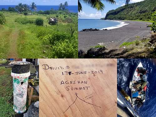
After the successful first ascent of Agrihan (trip report here), I (ClintK) wanted to mount a return expedition so my uncle (RogerK) and others could summit as well. It was believed that recent press (Outside Magazine, Backpacker Magazine, UCMC presentations) would generate lots of interest. Not to be. After sending out lots of emails and posting to several groups we ended up with a small team - mostly due to costs or time constraints. The team consisted of: DavidB, DavidD, JeremyD [2015], ClintK [2015, 2018], RogerK [2015], RobS. We hired 4 locals to cut the trail and help porter supplies: InosG, JoeO, RayS and LawrenceT. Many other locals supported the team including the northern islands mayor's office, the villagers living on Agrihan and the Super Emerald's owners/crew.
[Photos: while I haven't given individual photo credits, I want to thank all team members who have shared their photos.]
Early on it was decided to follow the SouthSouthEast Ridge route - the one used in 2018. It's a known route which allows us to leverage the village infrastructure/residents. We know what equipment is needed - so we don't have to bring "the kitchen sink" of gear. We also have a rough GPX track to aid us through the ravine complexes. These combined factors allowed us to schedule a trip with 7 days on Agrihan and feel confident we would succeed.
ClintK handled most of the logistics. He worked with the northern islands mayor's office (NIMO) to get permits and hire locals. He worked with the owners of the Super Emerald to charter the boat. We were fortunate to get a good rate for the "anchor" option. This year the boat would anchor off-shore from Agrihan and wait for the team. This was done for safety reasons since no team member had medical expertise as in 2018. If we summited early we could also return to Saipan early.
ClintK pared down the 2018 gear list to something more manageable. Team members identified which gear they could bring through a shareable spreadsheet. By end-May gear assignments were made and everyone managed to reach Saipan without excess baggage fees.
Those looking to mount future trips should read the 2015 trip report for logistical help and the 2018 trip report for a detailed route description. Note: camp locations mentioned below are those identified in 2018 - not the reality of 2019. The GPX track shows the reality camps of 2019.
All team members arrived in Saipan by June 10th. Some had come from Guam where they had climbed Mount Lamlam (highpoint of Guam). The two "newbies" to Saipan went off sight-seeing and climbing Mount Tapochau (highpoint of Saipan). Others went shopping for last minute food for Agrihan.
ClintK and RogerK did all the "team gear" shopping for items which the team didn't bring from home. Namely tarps and stoves. Although "heavy" we used the butane canister stoves which are common to the islands. We didn't find any white gas and locals confirmed you can't find the isobutane canisters most backpackers use. We also pre-ordered water and left instructions for it to be delivered to the dock.
In the evening of June 10th we had our team dinner. We had invited the NIMO mayor, the boat owner/captain and JoeO (lead cutter) to join us. It gave everyone a chance to meet-n-greet.
At 1PM on June 11th the team hauled gear and supplies to the Super Emerald. Surprisingly this only involved 2 loads. It was quickly loaded onto the ship and bunks were "tagged" for tomorrows voyage. We had pre-ordered water and left instructions for it to be delivered to the dock. Unfortunately there was mis-communication and the delivery didn't occur until 3:30pm.
At 3PM on June 11th the team visited NIMO where we met the rest of the mayor's team. We confirmed final logistics involving the Agrihan villagers. The team signed the MAE and we were set! Everyone headed to bed early.
The team wakes early in anticipation of an 8AM departure. Except there's a problem. JeremyD is not feeling well; perhaps a combination of jetlag, adjusting to the heat/humidity and motion sickness. After considering options we decide to delay the departure to 10AM. The boat owner is not happy but accepts the change. Two hours later JeremyD feels even worse and makes the call - he's staying back. [In hindsight a great call. He stays in Saipan for 3-4 days before recovering well enough to return home]. We borrow his ice axe, crampons and harness which will be needed to lead the crater rim traverse.
During the 2 hour postponement the team sets up a fixed line and shows the local cutters how to gear up and travel safely along a fixed line. This will be needed for the final pitch to the summit. The rest of the climb can be done "jungle gym" style.
We leave the dock around 10:15AM with everyone on the top deck watching Saipan disappear. Two hours later Saipan is still present and some still get cell service. It's a long journey north to Agrihan. Team members nap, talk and generally the sun/sea. Excitement increases as we pass each island but then settles down. The captain's house is a favorite "hang out" due to its air conditioning. The seas are "medium" with 6-10 feet swells which most people handle well.
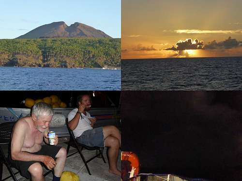
People start waking around 5:30AM - just in time to catch sunrise over the waters just north of Pagan. Although we started late yesterday we drop anchor off-shore near the southwest village of Agrihan at 8:00AM. The Agrihan flies have already sent out a welcoming party; subsequent days the boat anchored further off-shore to avoid the flies. We offload everyone and our gear/water for a week in 3-4 trips in the ship's skiff.
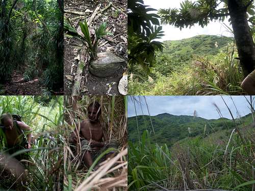
Around 9:30AM the four cutters head off to clear the forest trail and start into the swordgrass. DavidD and RobS (using head nets) armed with a hand saw, flagging and their day's food/water join them. The plan is that they will spend most of the day cutting trail while the rest of the team establishes a base camp.
DavidB, ClintK and RogerK hang back and establish a base camp around the old dispensary building. The villagers are very helpful - they have an ATV which carries most of our gear/water up from the beach. You can see slight changes since last year - mostly due to repairs from typhoon damage in 2018.
Once gear is organized and camp sites identified, DavidB and ClintK load their packs with water and head into the forest around 10:30AM. The going is slow due to the heat/humidity but they eventually reach the rest of the team around 1:00PM. For ClintK a lot of the forest trail is deja vu from 2018. There are a few re-routes but the flagging and trail is in remarkable shape - DavidD and RobS have done an excellent job cleaning up the trail while DavidB and ClintK kick coconuts out of the way to ease transport of water/gear.
When everyone meets at 1:00PM we are well into the swordgrass headed toward Camp 1 from 2018. There is a small "tunnel" down low which can be followed through the swordgrass. This is the trail tread from 2018. Swordgrass has completely grown into the path - enough that it's difficult to bash your way through. Still, this "tunnel" makes it easy to cut the swordgrass back and re-open the path. Credit needs to be given to the 2018 team which really cleaned the trail tread and aided this "tunnel". ClintK's experience from 2014/2015 was contrary to this where limited tread clearing in 2014 meant the tread was mostly non-existent in 2015.
The team continues up and reaches the ridge line around 2:00PM. By this time the cutters are starting to complain about the work. They want to quit while we would like them to continue working until we reach Camp 1. With the aid of GPS, DavidD and ClintK eventually find the Camp 1 tree and 6 gallons of cached water around 3:00PM. It also shows that not all "tunnels" are the real tread from 2018. For example, we approached Camp 1 from the 7:30 position while in 2018 was approached from the 4:00 position.
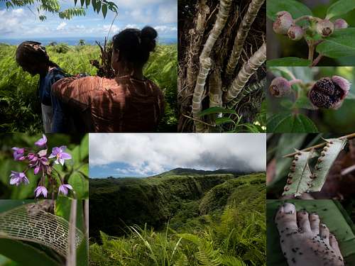
The entire team heads down to the beach and base camp. It feels great to swim in the ocean and have a bucket shower to clean up. Note: the locals avoid swimming because of the frequent (tiger) sharks attracted to the area due to spear fishing. It's strongly advised you only wade in. There are hundreds of mangoes to eat with our dinner. We prioritize gear hauls for tomorrow and head to our tents early. We have made phenomenal progress today!
DavidB, ClintK and RobS head out early (5:30AM - 6:00AM) with our first load of gear/water. The plan is to haul it to Camp 1 and drop it. Return to base camp and bring up a second load of water. It's nice to see that we are already acclimatizing to the heat/humidity with decreased hiking times to Camp 1. As we descend we pass JoeO and LawrenceT headed up to Camp 1 to start cutting trail to Camp 2.
Unfortunately, there was mis-communicated between ClintK and DavidD - no wake-up check. Thus DavidD heads out with his first load around 9:00AM. We see RayS and InosG heading up with fully loaded packs around 9:30AM. They are going to be challenged to reach Camp 2 by this evening with all that weight. DavidD hauls their heavy pack up to Camp 1 instead of doing a second haul of water. DavidD, ClintK and RobS spend the afternoon shuttling gear/water from Camp 1 toward Camp 2 (or wherever the cutters have reached at that time). We return to base camp between 4-5PM and enjoy a swim/shower and "real" food.
DavidD and RobS discover a "secret" about the building. One of the rooms is mostly enclosed and thus dark enough the flies don't enter - even during daylight hours. The downside is it's hotter than heck, but it's the lesser of two evils. We end up holding many team discussions in this room to get relief from the flies.
RogerK, being the elder of the team, packs his sleep gear and a day's food/water and departs base camp early. His plan is to slowly hike up and stay with the cutters from now on. He will not descend each day but stay on the mountain for the rest of the trip.
This evening two problems are highlighted which nag the team for the rest of the expedition. First, there is a lack of radio communication between the various groups of people. For example, we find out the cutters and RogerK reached Camp 2 around 3:15PM by a message relayed from the boat to the villagers. Another example is ClintK was slow returning to base camp which caused DavidD/RobS to be worried. Due to line-of-sight issues, not all of these examples can be handled, but far more FRS radios should have been available.
The second problem is that certain team gear doesn't make it to "lead" camp each night. For example, the stove never reaches RogerK and the cutters so they have to revert to camp fires. Or the rain catchment system never reaches Camp 2 in time so it could be setup. The original plan was to have one of the climbers (on a rotating basis) stay overnight at "lead" camp. They could ensure team gear was hauled to that camp each evening, as well as start hauling gear/water upward in the morning. Unfortunately, this didn't happen. The problem is the climber would have to haul his sleep gear back down to base camp when he was rotated out.
Being the fastest on the team, DavidD heads out around 5:30AM and reaches Camp 2 around 8:00AM. There he meets JoeO and LawrenceT as they are just starting to cut trail today. DavidD has a GPS track to help them find the path through the D1 ravine complex. They are fairly accurate although the big/steep descent is off and quite challenging this year. The final 10 feet is a vertical drop which requires a tight grip on a static line. A few of us slip and fall on our back. [50+ft of static line is needed].
There are two advantages for leaving so early. One, the flies come out at sunrise (5:15AM - 5:30AM). They're already pestering you at breakfast, but they dislike the darker forest so you have a respite until you enter the swordgrass. The primary reason is so you can reach Camp 1 and possibly Camp 2 before the sun comes over the ridge and turns on the swordgrass furnace.
Yesterday DavidB had hauled gear with the intention of camping up high at lead camp. The heat/humidity and weight wore him down so he returned to base camp and rethought his strategy. Today, with a lighter load, he heads up with the goal of reaching Camp 3 and staying with RogerK and the cutters as they progress. He'll also help haul gear/water between Camp 2 and Camp 3.
The heat and sun are oppressive today. DavidD and ClintK make another haul from Camp 1 to beyond the D1 ravine. Meanwhile RobS moves most of the water from Camp 1 towards Camp 2 getting it all cached around the steep fern climb. By 1:30PM it's clear we are all wasted. From RogerK's notes its noted the cutters were also feeling the heat. They stop around 1:45PM and establish Camp 3. Given our lack of energy we make the fateful decision to start hauling unused gear back down to base camp. That way we'll have less work to do after summitting. For example, we bring the rain catchment system back down since it hasn't rained enough in the last 3 days to collect any water.
The three of us start heading down to base camp. It's a slow descent as we stay together as a group yet ClintK is exhausted. A typical stop is 15-20 minutes - rest to cool down, choke down some food/water, rest to digest - then proceed. We reach the forest around 3:30PM. Feeling "safe" we split up. DavidD heads out first, followed by RobS and finally ClintK. Around 4:30PM ClintK finds RobS's trekking pole. A few yells yield no response so it's figured the pole was left/dropped by accident. At base camp around 5PM DavidD and ClintK realize RobS is missing. We ask the villagers to help us search for RobS in the forest. DavidD finds RobS in a ravine about 75 feet below the trail - roughly where the trekking pole was found. RobS is in bad shape; no massive bruising from the fall but he's unresponsive. It appears to be heat exhaustion bordering on heat stroke.
The villagers bring up a cot which is used as a stretcher to carry RobS down the last 1/4 - 1/3 mile of rough trail. Without the help of villagers ChrisK, AJS, CJT and JeremyT this would have been an impossible task. EddieS brings the ATV as close as possible and aided getting RobS to the beach by 7PM. Fortunately, Agrihan now has a skiff with a working motor. We load RobS into the skiff and reach the Super Emerald around 7:20PM. A rescue basket is lowered and RobS is brought aboard and put into the air conditioning. A bag of ice is found and used to quickly cool RobS.
Over the next 2-3 hours satellite phone calls are made while RobS rests and cools down. Since the accident didn't occur on water, the Coast Guard will not respond. We have to self-rescue. A big problem is that most of the team is on the mountain and we don't have radio communication with them. DavidD calls relatives who are doctors and confirms our treatment route. By 10PM RobS is recovering. He can respond to questions and operate his iPhone. The decision is made to stay overnight at Agrihan and re-assess in the morning.
The morning brings good news. RobS was able to get up and use the toilet by himself during the night. He's fully responsive, feeling much better and has an appetite. RobS decides to stay on the Super Emerald while the team continues to the summit.
DavidD and ClintK return to shore around 8AM - completely worn out from yesterday's activities. It was debated whether to call it a rest day to try recovering. Or maybe wait until 4PM and head up to Camp 2. But how do we find cool/shaded areas to rest (swimming all day would either turn us into shark food or sunburned prunes. and how to communicate our decision to Camp 3 (not in line-of-sight)? We ultimately decided to pack light (so much for a summit beer) and "suck it up". We pack assuming tomorrow will be summit day and we'll descend to base camp.
We are encouraged when we pass the D1 ravine. All of the water is gone which is good news - the rest of the team has it. We pare down the climbing gear and start on the long, slow, gentle grind up toward Camp 4. While we got roasted by the sun down below, as we climb higher more clouds are present. This part of the trail is not "deja vu". It seems to be to the west of the 2018 trail with higher ferns and more patches of sword grass. ClintK forces a long rest maybe 15 minutes below Camp 4.
It turns out the trail bypasses Camp 4 and avoids the D5 ravine complex completely. Once we drop into the D6 ravine things look familiar again. DavidD and ClintK are all smiles when they reach Helicopter Ridge and can see the tarps flapping. The team is finally together at 5:30PM. With cooler temps (72F) appetites return and Chef Boyardee never tasted so good. RogerK uses the satellite phone to communicate with the Super Emerald and let them know we are all safe and together with the plan of summiting tomorrow.
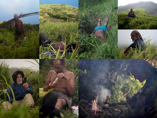
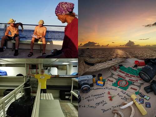
5:30AM sure comes around quickly. It rained last night and the wind driven tarp beat up people sleeping near the edge - but it was a good sleep. We have breakfast and pass out climbing gear. We depart around 6:30AM with RayS, ClintK and DavidD taking turns leading the way along Stegosaurus Ridge to P960 (false HP). The team arrives at P960 around 7:30AM. No celebrations this time. It's been thick fog/clouds which means no views ;( The good news is that even though flies are present they aren't such a nuisance this high.
DavidD and ClintK soon head off to start securing the crater rim traverse. The first drop-off is quickly set by DavidD with fixed line. The ladder section is reached around 8:00AM. DavidD and ClintK establish an anchor and ClintK is belayed out along the base of the ridge. An ice axe (portable anchor) is perfect for this task along with front-point crampons. Two aluminum stakes are hammered in as protection but the final climb into the ridge notch is fairly straight-forward. ClintK finds the 2018 anchors and after hauling up his backpack quickly sets the caving ladder. After down-climbing and cleaning the route the team ascends the climbing ladder and continues towards P952.
DavidD and ClintK repeat the process for the final pitch to the true highpoint of P952. ClintK hammers in two stakes along the pitch and reaches P952 at 9:50AM. The lead rope is turned into a fixed line and the rest of the team reaches the summit by 10AM. Unfortunately we didn't practice fixed line travel with the cutters at High Camp. They felt safer straddling the fixed line and simply using their hands versus jumars.
The summit team consisted of DavidB, DavidD, ClintK, RogerK and two local Chamorros - JoeO and InosG. [ClintK: there was great satisfaction in seeing RogerK on the summit. Third time was the charm for him as well (2014/2015/2019)]. The team spends about 30-45 minutes savoring the summit. The summit register from 2018 was still present but RogerK replaced it with another more secure version. We signed the register and started breaking up. Most people wanted to start descending - enjoy the beach and relax. Fortunately the clouds break and they get excellent views of the crater and southern slopes of Agrihan before leaving. DavidD leads this group off the crater rim traverse. They descend, hauling almost all the gear off the mountain, and reach base camp in the late afternoon.
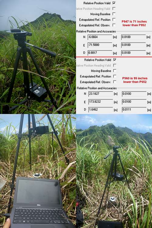
ClintK and RogerK stick around the summit area. They've brought a real-time kinematics GPS system from uBlox with them. They want to confirm that P952 is the highest point of Agrihan. This base/rover GPS system will allow them to measure the relative heights of the candidate peaks. The base unit is set on the summit of P952 while the rover will be carried to P947 and P960. After a short survey period the base unit has the altitude as 967.853m +/- 0.924m MSL or 3175ft. This runs counter to two phones which measure the altitude at 3198ft.
Regardless, we are interested in the relative heights which are accurate to +/- 0.01m. The general setup is to use a tripod and mount the GPS antenna on top for a clear sky to the satellites. The radio link is strapped to the support legs to keep the antenna above the surrounding vegetation which degrades the signal-to-noise ratio.
ClintK first carries the rover to P947 which is about 240ft to the west. Once a fixed solution is found, P947 measures 71 inches lower than P952. ClintK then traverses to P960 which is about 575ft to the east of P952. It takes longer to achieve a fixed solution, but confirms that P960 is 99 inches lower than P952. The relative measurements GaryR performed in 2018 with a Sokkia B24 survey-grade level are surprisingly close (although with a larger error tolerance) to these GPS measurements. I think this conclusively proves that P952 is the true highpoint of Agrihan. Without a long survey period I'm hesitant to specify the absolute height, but 3175ft +/- 3ft is probably good. This is relatively close to the official USGS height of 3166ft, although much lower than the 3198-3204ft measured with various smartphones in 2018/2019.
Taking the rover back-n-forth takes time. RogerK and ClintK don't depart P952 until 2PM. Fortunately, it's been mostly cloud-free which means lots of distractions looking into the crater and surrounding area. RogerK belays ClintK as they clean the route and return to P960. From there it's a slow descent (bad knees and why hurry) to High Camp. We pack our gear and continue the descent until 7PM - fortunately at Camp 3. By the time we reached Camp 3 the cooking fire JoeO and InosG started for us had gone out. Not to worry, we've got lots of food and just enough water. It's a relief that we can contact the Super Emerald and let everyone know we are safe. We ask that two locals start up the trail tomorrow morning to meet us and help us carry our gear down to base camp.
Finally, it really rains. Unfortunately RogerK and ClintK are tucked under small tarps and both get wet. Still, first fly is at 5:15AM and we are up and descending by 6:30AM. We pick up the last cache of gear at the base of the D1 ravine. It takes multiple hauls to get the gear and people up D1, but RogerK does remarkably well. We meet JoeO and LawrenceT shortly below Camp 2 around 9AM. We give them a bunch of gear and continue down, reaching Base Camp by 10:30AM.
No rest for the weary. It's time to sort gear, pack it (wet, dirty and stinky) and get it hauled down to the beach. Again, the villagers help haul the gear on their ATV. We have final group photos on the beach and start loading the Super Emerald. We are all aboard by 1:30PM. Most climbers take a quick shower before the boat weighs anchor; the challenge is finding clean clothes to put on afterwards.
We asked the boat owner to cruise around the south of Agrihan and visit the southeast beach. This was the alternative landing and route options in 2018. With calms seas the trip is easy. There is a rocky landing (similar to Alamagan) almost directly inline with route R3 and a nice beach landing where the satellite photo shows it. There appears to be a slight headwall from the landing but then the route up R3 looks easy with JoeO observing ferns along the way. This could potentially save you a day of machete work and skip the D1 ravine complex entirely. Something for future expeditions to consider. The downside is sea conditions could prevent a drop-off/pick-up (most storms come from the southeast) and there is no village infrastructure to support the team.
Once we've done the recon work, the ship turns south and heads to Pagan. We arrive in the sheltered cove of Pagan around 7PM. We anchor but don't go ashore. Instead the crew cooks an amazing dinner which we dive into by 8PM. We finish dinner under a moonbow! Most people are in their bunks by 10PM. The Super Emerald departs Pagan around 11PM and it's a slow cruise home to Saipan. Fortunately the seas are reasonable.
Patience is a virtue. It's surely tested today - as with all the return trips from the northern islands. All we want to do is get back to Saipan, take a shower and eat real food. We pass Anatahan shortly before lunch, but that means we'll arrive in Saipan around 7PM. It's a relief to see the dock and off-load.
Unfortunately, there was confusion about the waiting rental car. The keys weren't left with the hotel staff. We eventually make alternate arrangements and get car shuttles going. Once checked in we shower and get laundry bags ready. Then it's off to Godfathers Bar for the "Welcome Back" pizza and beer accompanied by good music. The beds never felt better.
Sufficient food and water (especially important due to the heat and humidity) is needed for all team members. You may consider bringing supplemental food and water for any locals you hire since they tend to underestimate their needs.
You may want to secure the Class 4 crater rim traverse using:
The ropes are also useful as hand lines through the D1 ravine complex - especially when carrying heavy packs/supplies.
KSPN2 TV interview with several team members after returning (June 20, 2019) - https://youtu.be/S_H8gsmr754?t=886 [14:45 - 18:15]
Marianas Variety newspaper article written by team member DavidB - http://www.mvariety.com/special-features/my-marianas/113643-the-7th-summit
DavidD's GoPro Fusion videos - https://www.youtube.com/playlist?list=PLIwMe5OjcX0MYd5zgrXY714hy_a97LjwO&app=desktop
ClintK's photo colage album - https://photos.app.goo.gl/kz83BaLABX65u9tu6