
-
 50703 Hits
-
 92.55% Score
-
 41 Votes
|
|
Mountain/Rock |
|---|---|
|
|
52.30000°N / 117.4666°W |
|
|
11884 ft / 3622 m |
|
|
Overview
Mount Alberta is the highest point in the Winston Churchill Range. For years, this unclimbed peak was the cover photo on the Guide to the Canadian Rockies.
It took a team of climbers from Japan to respond to this not-so-subtle taunt: Alberta was first climbed 1925 by S. Hashimoto, H. Hatano, T. Hayakawa, Y. Maki, Y.Mita, N. Okabe, guided by Hans Fuhrer, H. Kohler, and J. Weber in 1925.
Mount Alberta, one of the last major summits of the Canadian Rockies to be reached, isn't visible from any road, even today.
Even by its easiest route, this peak remains a major undertaking for the modern climber. It has a long and strenuous approach over Wooley Shoulder, devious routefinding to get to the base of the technical climbing, and many pitches of challenging rock on the notoriously unstable Rockies shale.
The log book at the Lloyd MacKay Hut correctly notes: "The approach to Alberta from here makes Wooley Shoulder feel like a maintained Parks trail!"
Many parties are turned back before ever coming to grips with the long, usually corniced summit ridge. And reaching the summit of this mountain is only half the adventure. The Japanese Route must be reversed in its entirety before arriving safely back in camp.
It takes good conditions and a very efficient party to climb even the easiest route in a day. Mount Alberta is rarely climbed compared to most peaks in the Canadian Rockies. Many years the mountain never sees a successful attempt due to hazardous corniced conditions and weather along the summit ridge.
This mountain was the last attempted climb of Tobin Sorenson, who fell while attempting to climb the North Face, solo. Rest in Peace, Tobin. You are missed.
"50 Classic Climbs of North America" by Steve Roper and Allen Steck, and "Climbing in North America" by Chris Jones, offer very complete accounts of the first ascent of this peak, and give a feeling for historical significance of this feat.
At "only 5.6", the Japanese Route is one of the most challenging I have ever encountered. Good luck!
 |
Getting There
Drive north on Icefields Parkway from the Information Center. Ford the Sunwapta River at the gravel flats opposite Wooley Creek. Many parties use hip waders to make their crossing of the deep, fast, braided channels more comfortable, storing the waders on the far bank for the return trip.
If you use this strategy, hang your rubbers in a tree, out of reach of the rodents who have been known to destroy footwear left here.
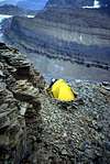
After reaching the far bank to the left of the mouth of Wooley Creek, follow the creek to its headwaters (generally along the left bank), climb endless talus, and cross escalator scree over Wooley Shoulder, then across the glacier to the Lloyd MacKay (Mt. Alberta) Hut. The peak is obvious from there.
 |
When To Climb
Mt. Alberta is usually climbed in August. The optimum time to attempt the peak is during the driest, hottest summer you can find. However, in these conditions you can expect to encounter more hazardous swift deep water when fording the Sunwapta River and Wooley Creek tributaries.
The fording of the Sunwapta is one of the greatest objective hazards of the ascent of the Japanese Route.
External Links
- Gary Clark's N.A. Classics
Japanese Route on Mt. Alberta - Japanese Route (2003)
- Lloyd MacKay (Mt. Alberta) Hut
Alpine Club of Canada backcountry huts. Link to Alberta Hut page. - Peakfinder page
An excellent information source for anyone considering attempting this peak. - Accident History