
-
 5203 Hits
-
 87.76% Score
-
 25 Votes
|
|
Mountain/Rock |
|---|---|
|
|
44.33290°N / 10.19545°E |
|
|
Emilia - Romagna |
|
|
Hiking, Mountaineering, Ice Climbing, Mixed, Scrambling, Skiing |
|
|
Spring, Summer, Fall, Winter |
|
|
6617 ft / 2017 m |
|
|
Overview
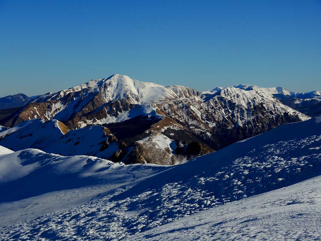
Alpe di Succiso 2017 m
The group of Succiso is located in the Northern Apennines along the Tuscany - Emilia Romagna watershed between the Lagastrello Pass to the North-West and the Cerreto Pass to the South-East. The highest mountain is Alpe di Succiso, or simply Succiso, one of the seven peaks in the Northern Apennines exceeding 2000 meters. Alpe di Succiso isn't situated on the main watershed, but it's slightly protruding out to the North and it's separated from Monte Alto, lying on the main boundary ridge, by the Passo di Pietratagliata.

|

|
The mountain is wild and isolated and has a pyramidal shape, engraved on the North side by several gullies. Three main valleys go forward the mountain: the valley of Liocca, the valley of Rio Pascolo and the valley of Secchia. Alpe di Succiso is joined to the adjacent Monte Casarola by a ridge along which it runs the Normal route from Rio Pascolo.
Getting There
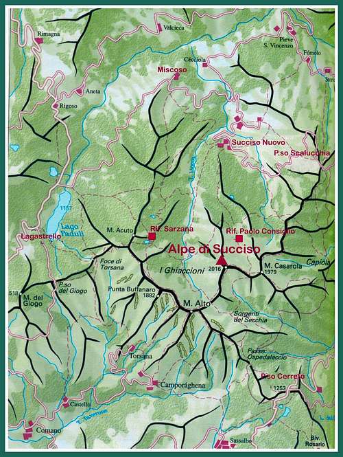
Alpe di Succiso is a complex mountain, which can be approached from various starting points: Passo del Lagastrello and the villages of Succiso Nuovo and Miscoso to the North, Passo della Scalucchia to the North-East, Passo del Cerreto to the South and Cerreto Alpi to the South-East.
Alpe di Succiso Normal Routes
Normal Route from Succiso Nuovo
Difficulty: easy scramble in summertime, Alpine F+ in winter (ice axe and crampons are essential)
Vertical gain: m. 1050
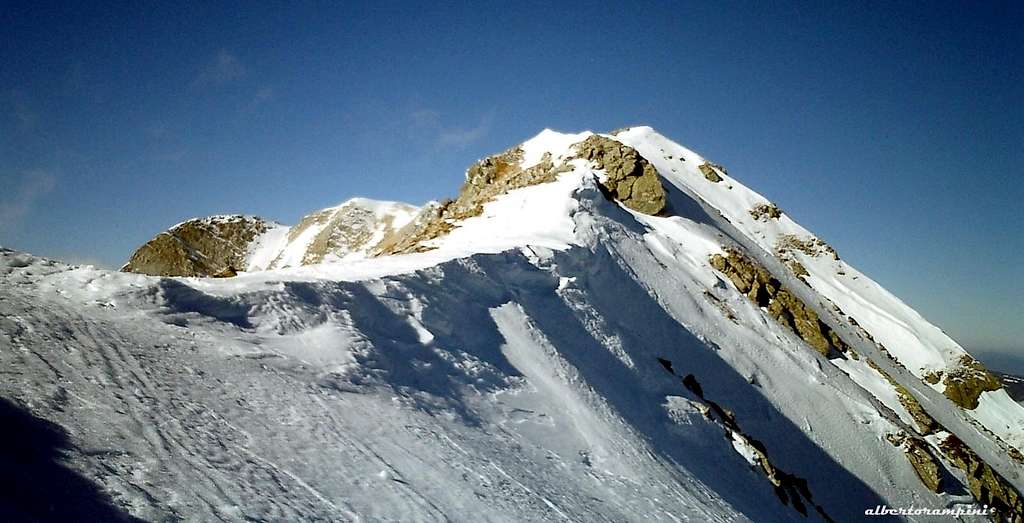
It’s the most popular route amongst the normal ones to climb Alpe di Succiso, even if not the shorter, facilitated by the presence of Rifugio Paolo Consiglio. From Succiso Nuovo m. 975, take the path 655 getting to the shelter m. 1570. The ascent route continues along the path n. 675 rising along a wide valley towards SE and steeply getting the Sella Casarola m. 1946, a slightly marked saddle on the watershed ridge between Monte Casarola on the left and Alpe di Succiso on the right. From the saddle proceed to the right towards West following the long summit ridge East oriented to the summit signal.

|

|
Normal Route from Passo della Scalucchia
Difficulty: easy scramble in summertime, Alpine F+ in winter (ice axe and crampons are essential)
Vertical gain: 650 m
Park your car on a hairpin m. 1364 just before reaching Passo della Scalucchia. Take the path n. 667. After reached Buca del Moro m. 1483 at a crossroads - junction with path n. 669 - continue always along the path n. 667, out of the beech forest and along wide hairpins up the Northeast slopes of Monte Casarola, reaching the summit of this latter at m. 1979. Descend briefly in the opposite direction to the Sella Casarola - signposts - and from here follow the long ridge to the West as the previous point to reach the summit of Alpe di Succiso.

|

|

|
Route across Monte Alto SE ridge from Passo del Cerreto
Across Monte Alto SE ridge from Passo del Cerreto
Difficulty: in summer this route requires some easy climbing on the ridge to Monte Alto, while in winter on mixed ground (rock, ice and snow) the route becomes more challenging (Alpine AD) and requires climbing gear, in addition to ice axe and crampons
Vertical gain: 800 m, but greater development
Road access - Starting from Castelnovo ne Monti take the road to Passo del Cerreto
Route report - Starting from the Passo del Cerreto, this itinerary runs along the southernmost section of the Groppi di Camporaghena chain, a rough ridge with NW-SE orientation located between Passo del Lagastrello to the NW and Passo del Cerreto to the SE, alternating trails and short easy climbing. From Passo del Cerreto m. 1261 follow the path 00 signposted Sorgenti del Secchia and Passo di Pietra Tagliata starting on the right of the shelter. After about half an hour on a flat path you reach a signposted Junction with a forest road on Passo dello Ospedalaccio m. 1281. Follow briefly the forest road to the right, then turn to left on the path that rises rather steeply up to a crossroads: ignore the right trail n. 671 heading to Sorgenti del Secchia an take the path 00 rising straight towards Monte Alto, to reach its ridges.

|

|
After a steep and direct ascent, the routes reachs the rocky ridge of Monte Alto, more thin in the second section, getting a rocky outcrop. Bypass the spur on the left and after a short downclimb go up to a junction (signpost Camporaghena). Ignore it and continue along the 00 path, reaching soon the summit of Monte Alto m. 1904. From the top of Monte Alto descent to the North side taking the path 673 scrambling down to Passo di Pietra Tagliata. This col cut amongst the rocks is a crossroads of different paths; follow the n. 671 towards Alpe Succiso which after a few meters reach the bottom of a rocky outcrop, equipped with metal cables. You can climb this short "Via ferrata" or bypass it on the right side. The trail climbs up steeply the following ridge reaching the summit of Alpe di Succiso m. 2017 after about 45 min. from the Passo di Pietra Tagliata.
Descent - reverse the same route to Passo di Pietra Tagliata, here take the path to the Sorgenti del Secchia and the beautiful meadows called "Il Prataccio", where at a junction the right path comes back to Passo dell'Ospedalaccio and P.sso del Cerreto.
Route across Sella di Monte Acuto-Buffanaro ridge (Groppi di Camporaghena)
Route across Sella di Monte Acuto - Buffanaro ridge (Groppi di Camporaghena)
Difficulty: in summer this route requires some easy climbing equipped with fixed ropes on the ridge between Sella di M. Acuto and Monte Alto, while in winter on mixed ground it becomes more challenging (Alpine PD) and requires climbing gear, in addition to ice axe and crampons
Vertical gain: 800 m, but greater development
Road access - Starting from Parma we follow the SP 665 Massese to Passo del Lagastrello passing through Langhirano, Pastorello, Palanzano and Monchio dei Corti. We continue in the direction of the great artificial dam of Lago Paduli at a short distance from Passo del Lagastrello. A few meters before the dam we ignore the road to Aulla and turn to left (signpost Miscoso). Shortly after the bridge, park the car (info panel).
Route report - The route starts skirting the lake's fence to a meadow where it's located an ancient stone dating back to 1863. At the fork leave the path n. 659 (towards Rifugio Sarzana) on the left and take the 659A, starting on the right. After a clearing where the path crosses a stream, there's a second fork, where we always keep the right (659A), getting to another junction where this time we take the left, always on the path 659A in the direction of the Sella di Monte Acuto. The route follows the meadows of the Costaccia and gets the Sella di M. Acuto m. 1721. From here with a brief digression we can climb to the nearby summit of Monte Acuto m 1785 in about 10 min., or ignore this peak and continue straight along the ridge, getting the start of the Sentiero Attrezzato Groppi di Camporaghena (signpost), equipped with some iron ropes. The route descends to a saddle, then climb up on a wide ridge at first wide, then becoming thin and exposed, reaching the Sella di Punta Buffanaro 1752 m., where there's a junction (signpost) with the path to Rifugio Città di Sarzana. Continue along the ridge keeping mainly on its right side, in view of Punta Buffanaro, reaching the summit at 1879 m. From Punta Buffanaro the route descends along the sloping ridge, it follows a narrow rocky ledge, then a small saddle 1822 m. with a signpost to Foce di Torsana.

|

|
We keep the main ridge, starting again to climb up and overcoming some rocky outcrop in view of the summit of Monte Alto and to the left our final destination, the summit of Alpe di Succiso, still far away. After a steep stretch equipped with metal cables, the route reachs the summit of Monte Alto 1904 m. From here continue as described in the previous route.
Descent - from the top of Alpe di Succiso reverse the same route to Passo di Pietra Tagliata, here take the path to I Ghiaccioni and Rifugio Città di Sarzana.
North-East face ice gullies
The North East wall of the Alpe di Succiso in winter version offers a wide range of ice climbing with low technical difficulties. However, a good knowledge of the various snow and ice conditions is required in order to safely ascend. Necessary rope, harness, ice axe and crampons.

|

|
Access: once you have reached the Rifugio Rio Pascolo as described in the previous chapter "via Normale da Succiso Nuovo", you will soon reach the large basin above to get the base of the wall (0,15 hours from the shelter)
Red Tape
There are not particular restrictions in hiking, climbing and mountaineering. Anyhow, Alpe di Succiso is located entirely within Parco Nazionale Appennino Tosco-Emiliano: wood fires are prohibited as well as free camping and other harmful activity. The whole fauna and flora are protected. Don’t disturb fauna and other mountaineering and hikers’ peacefulness.
Huts
- Rifugio “Paolo Consiglio” m 1570 - unguarded , 24 places, 3,30 from Succiso Nuovo m. 980 along the path n. 655, winter shelter (2 places)
Situation: built in 1977 by C.T.G. Reggio Emilia the shelter is located on a moraine terrace in the valley of Rio Pascolo, at the foot of the North-East of the Alpe di Succiso. Dedicated to Paolo Consiglio, member of Club Alpino Accademico Italiano, who died in the Himalaya in 1973.

|

|
- Rifugio Sarzana m. 1581 - C.A.I. Sarzana – Open in summer and week-ends, 24 places, 1 hour and 45 minutes from Passo del Lagastrello m. 1159 along the path n. 659 GEA, winter shelter (6 places)
Situation: a nice wooden shelter located nearby the Lago di Monte Acuto m. 1577
When to Climb
It’s possible to climb all round year. Winter ascents require the essential gear as rope, helmet, crampons, ice-axe, ice-anchors.
Climate

Climate is subcontinental, with cold and snowing winters and pleasant summers, dry but not too hot, because of the mitigating influence of the Tyrrenian Sea and the action of the winds.
Meteo
Guidebooks and maps
 |
 |
“Appennino Ligure e Tosco-Emiliano” by M. Salvo and D. Canossini - Collana Guide dei Monti d'Italia CAI-TCI
"Appennino di neve e di ghiaccio" by Andrea Greci - Ed. Idea Montagna 2014
Maps
Appennino Tosco-Emiliano sheet 14 - 16 Multigraphic - Firenze
External Links
Parco Nazionale Appennino Tosco-Emiliano