|
|
Route |
|---|---|
|
|
34.27027°N / 117.67937°W |
|
|
Hiking |
|
|
Spring, Fall |
|
|
A long day |
|
|
Overview
From The San Gabriels Vol II by John W. Robinson, 1983, pp 167-168:
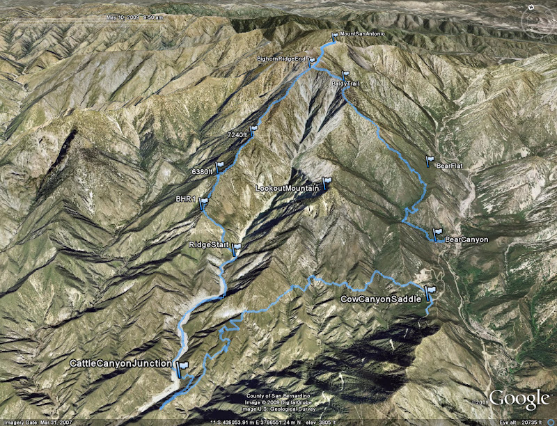
Although most parties ascending Old Baldy started from San Antonio Canyon and used either the Bear Flat or Devil's Backbone route, there were also other ways to climb the mountain. Some hikers took the northeast approach from Glenn Ranch, following the old miners' road up Lytle Creek to Baldy Notch, then up the Devil's Backbone to the top. From San Gabriel Canyon, Henry Roberts led parties up the peak via the East Fork and Prairie Fork as early as 1889. In the early years of the present century, a rough trail was built up the long southwest ridge of Baldy from Weber's Camp in Coldwater Canyon. With the demise of Weber's Camp in the late 1920s, the trail fell into disuse and disappeared.
The long southwest ridge is the Big Horn Ridge (BHR), and from what we've read there hasn't been any reports of anyone climbing this path other than the fact about 100 years ago there used to be a path. The idea of trying to ascend Mt Baldy this way was brought up in this forum thread. In it some potential routes were considered, but in the end no one had checked it out.
Extensive detail can be found on my trip report on here as well as the Original Trip Report Here.
Getting There
You'll want to park at Cow Canyon saddle, on Glendora Ridge Rd just mile from the junction with Mt. Baldy Rd. You can check other pages for more information on getting to Mt Baldy village.Route Description
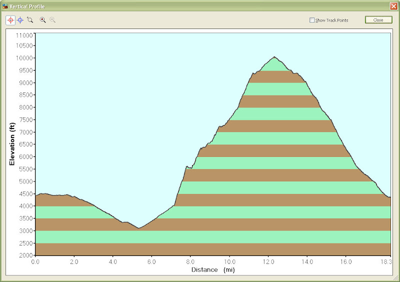
This route involves a wide variety of terrain conditions. First you'll descend the Coldwater Canyon truck trail to Cattle Canyon, about 5 miles. You'll then ascend up the canyon another 1.5 miles. Here, you'll begin to ascend up the east side along a small ridge that heads up to BHR. There will be lots of brush, although your time can turn out much better if you follows the paths of least resistance.This may be hard to do the first time, so please consider doing a recon, or use the gps coordinates from my trip report (should be quite accurate).
Once you reach BHR, you'll take the ridge all the way up to the junction with the Bear Canyon trail. Along the way, you'll try to stay on the ridge but will have to come down the western side a bit to avoid some spots where the brush is impenetrable.
Generally, as you get higher, the terrain gets nicer looking and nicer to you. However, there will be some sections of class 2-3 rock although if you pick the perfect path you may be able to avoid it.
You'll ascend over 6000 ft in 4.7 miles along the ridge portion.
Mt. Baldy via the Bighorn Ridge at EveryTrail