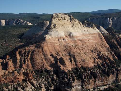
![North Guardian Angel from Cave Knoll]() NGA
NGA![South Guardian Angel from Lambs Knoll]() SGA
SGA![South Guardian Angel and Left Fork]() SGA
SGAIntro
When I first saw the South Guardian Angel in 2008, I was transfixed. What a spectacular peak...how far off...how imposing...
After reading
this trip report and learning that SGA is attainable for mortals, though not easily, I knew I had to climb this desert classic.
But why go after SGA if you're not going to go after its higher sibling North Guardian Angel as well? Good question. And NGA is no slouch. Also considered a desert classic, it is technically harder to climb than SGA is but is easier to get to.
Some go for both on the same day. Me, I couldn't do that when opportunity called. The time didn't exist. But I had to get at least a taste.
In April 2011, my wife and I hiked from the Wildcat Trailhead to the overlook of the Northgate Peaks. From there, I went on to climb each peak while she went on to get back to the car. How I ached to add NGA that day! How she gave me a "Don't; I'm being patient enough as it is about the Northgate Peaks"!
So I behaved and exercised some painful self-restraint. Knowing I'd be back the same time the next year helped. Knowing that snow might block the road to the trailhead the next year didn't. Now picture my wicked grin upon reading about the dry winter and the warm temperatures of 2012...
Okay, that's about all the NGA story I've really got. I went out, climbed the peak, loved it, and at the summit stared like a hopeless romantic lost in love at the South Guardian Angel so close, yet so far away. No, the Hall & Oates song wasn't playing on the wind, nor was it playing in my mind at the time, but when I think of that view now, I think of that refrain.
At last summer came and I had my chance to go for SGA. Some had warned me against it and suggested I try in cooler weather, but there were two reasons I had to make a summer attempt:
* I'd be by myself this time (my wife would never bother with something like SGA).
* Despite being a strong swimmer and a great lover of the ocean, I despise getting wet when I don't want to, and the standard approach route for SGA usually requires some wades and swims. Thus, if I had to get wet in the cold water of a dark canyon, it damn well was going to be during the summer. Ironically, in the end I did not use the standard approach but rather used one that I now regret. That lament follows.
Gripes
Have you ever climbed a peak and felt both pride and shame at the same time?
Although I'm no list-chaser, I felt proud to climb South Guardian Angel, a peak that many who pursue the Sierra Club's
Desert Peaks Section Peaks List save for last because the route can be long and complicated. Also, it's a peak that, based on the summit register, sees maybe five ascents per year (measured by parties, not total numbers).
On the other hand, I somewhat feel that an asterisk should be beside my entry. Bowing to convenience and concerns about the summer heat, I used a route that made it too easy and which, I now think, should be more obscure.
That route is what I refer to on the SGA page as "the cairned route." It avoids the 5.4 pitch and the swims. Another SP member had referred me to it with a link to a trip report.
Why did I not go what is today's standard route? Three reasons:
* First, that route involves downclimbing a short 5.4 pitch and then climbing it on the return;
no, 5.4 is not a deal-killer for me, but the pitch involves a smooth boulder, and I am much better with cracks and corners than I am with faces, so I was going to fix a rope to help on the return if needed. But I was concerned that some yahoo Subway hikers might steal or remove the rope, and after I learned of the cairned route, it just made more sense to go that way.
* Second, as stated above, I hate getting wet when I don't want to get wet, and I hate it to the point of being a baby about it. When I learned of a swim-free alternative approach, I was happy.
* Third, it was July, not exactly the recommended time to be going off-trail for several miles in southern Utah's sandstone backcountry. Actually, it's a recipe for death, but it was really my only option (see "Second" reason in the previous section for why I didn't want to go in any other season). The cairned route, being shorter and more certain, sounded safer.
But when I saw
how many cairns there really were out there, I felt that it was a real shame that a peak like SGA had been compromised that way. The cairns make it so that just about anyone in decent physical shape who is properly equipped and provisioned can climb the peak. And that's a shame. Although the cairns largely disappear during the second half of the route, where it's almost impossible to get lost, they are so prevalent that on the first half, "route-finding" consists of little more than looking for the next cairn; sometimes you can't help but see that next cairn before you even look for it.
Now, I have no real problem with cairns marking dangerous, confusing, or key spots, but a profusion of them, especially for a prize like SGA, is, I think, an abomination. A good diagram on a topo map would be a fair compromise.
I want to go back and climb the peak the traditional way.
I also want to go back and kick apart just about every cairn, even if it earns me condemnation. The cairns hold your hands, and I didn't like that. Due to the cairns, an elusive peak like SGA is too easy.
Okay, I won't do that, and the main reason is this: If someone goes out there to follow the cairned route, doesn't find it because I dismantled it in my zealotry, and then gets lost or dies from exposure or a fall, that person's blood will partially be on my hands, and I don't want to live with that.
But I can hope the Park Service will do it and then announce it and post a sign at the trailhead; in fact, I may write to the Park Service to request exactly that.
So I ask myself this question: Had I not known about the cairned route, would I and could I have used the traditional route? With full confidence, I can say "Yes." It takes a little of the shame off.
But I still need to go back and do it more honorably.
Goodness, I must sound like a whiner! Try to bear with me; for years, SGA had been built up in my mind as some kind of desert scrambler's Holy Grail, so imagine my disappointment with what turned out to be an overly marked way.
One might ask,
"So will these cairns lead to the degradation of the peak and its special status?"
In truth, they probably won't. It is still a long route for a desert peak. It is still mostly off-trail. There is still significant brush that most people will dislike. There are still a few scrambling moves that most casual hikers and list-checkers won't appreciate.
But it will still attract a few, maybe only a very few, who wouldn't have gone the traditional way otherwise. And that's a shame.
The Heat Is On
2-L bladder filled with water-- check. Bottle of Gatorade-- check. 32-oz Nalgene filled with water-- check. (After reading Aron Ralston's
Between a Rock and a Hard Place and realizing that the virtually unbreakable Nalgene bottle is probably what saved his life-- in addition to the sheer guts he employed to do what he did-- I resolved never again to go on any substantial outing into the desert without a Nalgene).
Food, including salty foods to guard against "water drunkenness"-- check. Various other items only there in case of having to spend an unplanned night out there-- check.
Ability to handle the heat-- Well, as it is with altitude, you never really know.
That day, it was forecast to be over 100 F in Springdale, meaning it would be around the low 90's in the vicinity of SGA.
I know enough of the desert to know that while 90-95 doesn't sound
that bad, it
can be
that bad come noon and several miles on one's legs in terrain that has no shade and which makes things worse by reflecting the heat off the rocks and directly onto you.
In short, it's heat that can kill, even if at the beach it's easily handled by adjusting an umbrella and pulling another cold drink from the cooler.
Nor am I a stranger to the summer desert; I've been out in it several times, including a time in Death Valley when I walked around in 130-degree heat while wearing just jeans, cowboy boots, and a cowboy hat. I thought I was being cool but probably just looked like a jackass. Still, it was one of several times that I have been in and dealt with the heat of the desert in summer.
So an hour before dawn, I watered the parking lot, threw on my pack, and set off. By the time I had fought through the nasty brush between the Northgate Peaks and North Guardian Angel, day's first light was making NGA's eastern face glow. In short order, I located the cairned route and had reached a Subway-like section of the Left Fork ahead of schedule. After a brief rest and taking some pictures following my locating the arch called the Jug Handle, a key route landmark, I set off for the climb back out of the canyon and onto the plateau above.
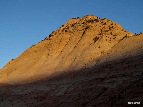
![Sunrise on North Guardian Angel]() Sunrise on NGA
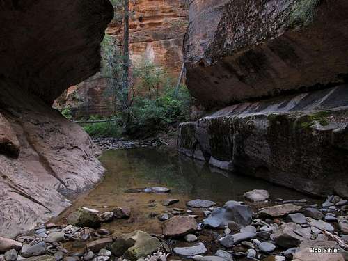
Sunrise on NGA![The Subway Tunnel]() Left Fork
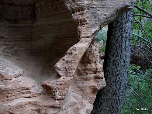
Left Fork![Jug Handle Arch]() Jug Handle
Jug Handle
Shortly after reaching the canyon rim, I found that the cairns disappeared for good, not that they were necessary anymore for anyone with a good map and any sense of the route.
The going was tedious for a bit because of all the brush in the wash twisting its way from the vicinity of Guardian Angel Pass, but I at last broke out onto the open sandstone and then the great slickrock bowl that accesses the NE ridge of SGA.
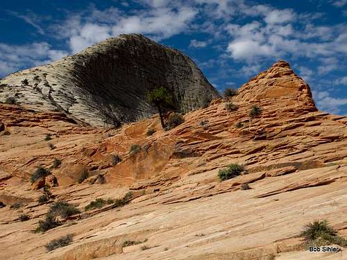
At last, a scene I'd obsessed over for more than four years was before my very eyes:
![South Guardian Angel and the NE Ridge]() SGA and the NE Ridge
SGA and the NE Ridge
Not much later, I was at last atop the peak. My goal had been to reach the top by 10; I made it shortly before 9:30.
At last-- a four-year obsession indulged! And the views!
I took some pictures and, although I'm not a big fan of summit cairns and registers, flipped through and signed the register. Many registers are worthless. Some are not. A very few are precious, being pieces of mountaineering history. The SGA register is somewhere in between the second and the third.
Then I desecrated the summit by pulling out my cell phone and texting first my wife and then a friend who knew and appreciated my SGA obsession. With withering scorn, the warming sandstone glared at me as I did so.
Return journey-- somehow, after descending the bowl, I got a bit off-route and wound up making dropping back into the wash a lot harder than it needed to be. But it's all in good fun as long as no one dies, right?
I took a long break once back in the shaded coolness of the Left Fork and then began the climb up, out, and back.
Somewhere on the way back up, the midday heat seemed to get to me. Even though I was in good shape, I felt tired. Despite short rests, keeping myself hydrated, and continuing to eat salty, high-energy foods as well, that feeling of weakness and wishing the end were near persisted. Small spots of shade became rediscovered Edens. Long slogs up the baking sandstone became not-so-subtle intimations of Hell.
Finally, I was back to flatter ground beside North Guardian Angel, but one of the worst parts of the route-- the trackless bushwhack to the wash below the Northgate Peaks-- still lay ahead. And it was in there that I first ran into what truly could have been serious trouble.
As I stepped through the brush, my legs cramped up to the point that continuing to walk was agonizing and nearly impossible. The first couple of times, some good stretches and massaging got me going again, but then came a time that the stretches did no good; it took several minutes for my leg to recover sufficiently for me to go again, and always I felt the next cramp just a step away.
Eventually, I reached the rock scramble back up to the overlook of the Northgate Peaks and the end of the maintained trail to there from the Wildcat TH. Carefully, always aware of my legs' seeming wish to cramp up again, I scrambled up.
The hike back from there was without event, but I was still accompanied by a feeling of being completely wasted.
And I was not right for the rest of the day. Back at the car, I packed up and then headed north on Kolob Terrace Road to the Lava Point area, where I'd never been before. While driving, I still had that completely wasted feeling. After a brief walk around at the overlook there, followed by lunch, I napped in the car, but even that did not restore me.
By late afternoon, I was at Cedar Breaks National Monument, where I would spend the night. Even then, I did not feel up to more than a short walk to the overlook behind the visitor center.
Around dark, I started feeling normal again, and after a solid night's sleep, all was well and I was off up I-15, bound for Montana and the next great part of a great summer.
But I won't forget how the heat got to me that day. Always follow the advice about how to be prepared for the summer desert heat. And be ready to deal with trouble no matter how prepared you think you are.
Thank you, my Guardian Angels.


Comments
Post a Comment