
-
 8923 Hits
-
 79.78% Score
-
 11 Votes
|
|
Mountain/Rock |
|---|---|
|
|
46.21004°N / 8.79052°E |
|
|
Hiking |
|
|
Spring, Summer, Fall, Winter |
|
|
6132 ft / 1869 m |
|
|
Overview
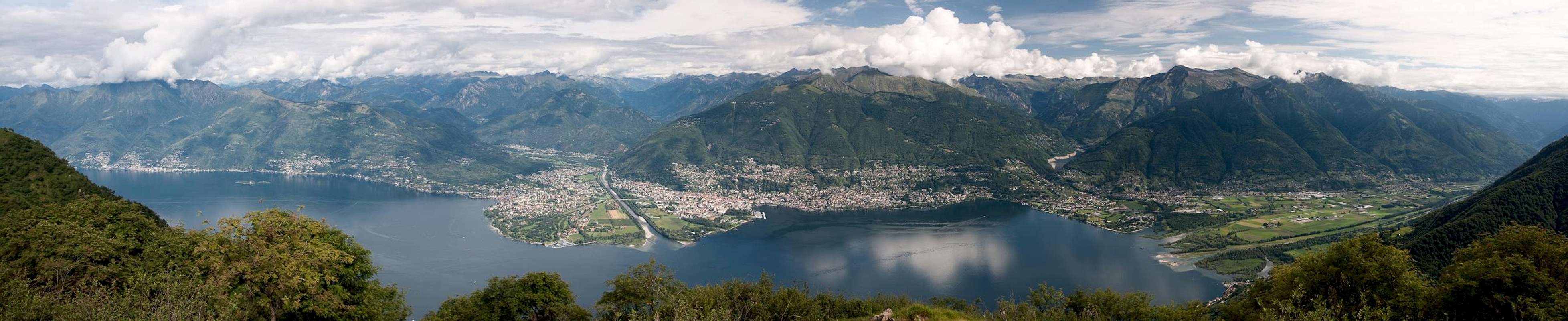

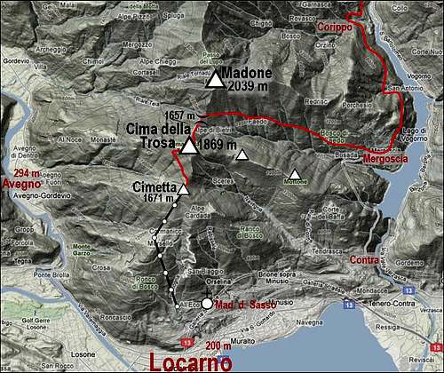
North of Locarno, starts a long crest of mountains which divide Val Verzasca and Valle Maggia. Rising almost out of a big lake their strongest point is a really nice panorama. That is why from Locarno a cable car was built on the first panoramic summit, Cimetta, 1671 m. From there, to Cima della Trosa you have less than 30 minutes of walk up. And the next summit towards the north, Madone, already exceeds 2000 meters. From Cima della Trosa one gentle side ridge goes down towards the SE, another one towards the SW (again branching on Cimetta) and the third one towards the W. The southern slopes of Cima della Trosa are covered with high alpine meadows which are connected with a dense network of marked paths. All of them very picturesque and panoramic. Lower on the side ridges, but still above 1000 m of altitude, the highest villages are nested. Cardada is connected with Locarno with a mountain road and cable car. Mountain roads are also very suitable for moutain biking tours. From the summit of Cima della Trosa the most attractive part of panaroma is towards Lago Maggiore and the mountains above it.
Getting There
 The bridge below Corippo
 Madonna di Sasso
There are many hiking trails on Cima della Trosa. Even if a big majority of visitors comes up from Locarno (by cable car), other, longer routes are also very attractive. So, here are the main trailheads:
1. Avegno, 294 m, in Valle Maggia. It can be reached from Locarno or Ascona, driving towards the NW into the valley (cca 7 km). There the western approach starts.
2. Locarno, 200 m. Many marked paths go up to Cardada village and further to the summits of Cimetta and Cima della Trosa. Above the town, there is the lower station of the cable car (a bit west of the famous pilgrim church of Madonna di Sasso).
3. Contra, 478 m. This village NE of Locarno is a trailhead for the hikes on Cima della Trosa over Monti di Lego (the SE ridge).
4. Mergoscia, 731 m. A village north of Contra, where the road ends. Its slopes are falling down into the artificial Lago di Vogorno, towards the west a very nice ascent path goes on Cima della Trosa.
5. Even further to the north is the beautiful village of Corippo, 563 m, above the northern shore of Vogorno lake. From there the marked path goes to Mergoscia (2 h 30 min).
Crossing Cima della Trosa
 Above Locarno
The proposed route is a wonderful one day hike, even if it can be also done as a part (start) of a multi day Ticino trekking (as we did it). We best drive first into Corippo and leave bikes there. So we don't have to care about how to return back to Locarno. The other options are busses which run through Val Verzasca regularly. Then we take the cable car up to Cardada and go first on Cimetta, then on Cima della Trosa and finally by a long descent to Megoscia and Corippo. Gear: Good shoes and poles. 1. Endurance: cca 250 m of ascent and ca 1350 m of descent. The paths are easy, T2 on the Swiss Hiking scale.
 On Cimetta
Route description. From Cardada, 1329 m, you can either take a chair lift, or walk up on Cimetta, 1671 m. Nice parorama there, supported by table descriptions. From Cimetta you just continue towards the north. First you descend a little (60 meters), from the saddle you then go up again by a good marked path. The summit of Cima della Trosa is directly above you, but you will most likely follow the path, which goes a bit more gently around (towards the W and then on top).
 Descending to Mergoscia
 Descending to Mergoscia
After reaching the highest point of your hike (of course you can later also add the summit of Madone, 2039 m, which can be reached by a marked path in another 1 h ascent), you continue descending towards the north. At first the marked path follows the E ridge, then it crosses the slopes and reaches the saddle (1657 m) between Cima della Trosa and Madone. If you have enough ascents, you turn there down towards the east. A nice path crosses the slopes of Madone, all the times going high above the valley of Mergoscia. After losing some 300 meters you hit the first nice huts, nested on sunny slopes. Nice scenes follow one after another, while you are descending through Motta, Bresciadiga and finally into Mergoscia. In Mergoscia, close to the village center, you must find a marked path further towards the NE and later N, in the direction of Corippo. Of course, if you decided in the morning to prepare bikes in Mergoscia, or if you don't have them at all, you can also immediately return from there to Locarno. If you go towards Corippo, a nice marked path leads you above the Vogorno lake. You go through forrests, ascending and descending a little, and after good 2 hours you reach the deep creek before the picturesque Corippo. An ancient bridge brings you over the gorge and a nice path then up into the village. There, or below it (on the N side) your bikes are waiting. If not, you may catch a bus in Corippo or in the main Verzasca valley.
Mountain Huts
- On the summit of Cimetta there is a mountain hut, opened all year long, except in November.
- Much towards the north, there is the Nimi hut, 2048 m. The ridge crossing from Cimetta hut to Nimi hut will take you some 4 hours, visiting the summits of: Cima della Trosa, Madone, 2039 m, Pizzo di Corbella, 2066 m.
- There are also many huts on the alpine meadows below Cimetta, for example on Monte do Lego (opened in summer on weekends).
Red Tape
No limitations.
When To Ascend?
Cima della Trosa can be best ascended in dry seasons, when the cable car operates. In winter the ascent over the summit slopes can be exposed to avalanches, if there's a lot of snow.