
-
 5429 Hits
-
 87.76% Score
-
 25 Votes
|
|
Mountain/Rock |
|---|---|
|
|
46.22243°N / 10.71162°E |
|
|
Trentino Alto Adige |
|
|
Trad Climbing |
|
|
Summer |
|
|
8753 ft / 2668 m |
|
|
Overview
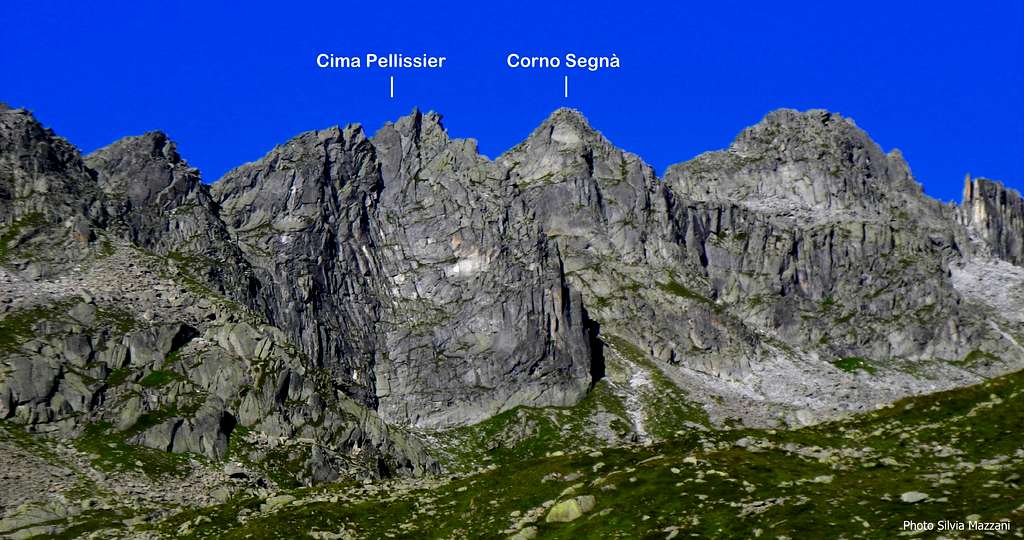
Corno Segnà 2668 m
Corno Segnà 2668 m is a minor peak, anyhow interesting and very well identified, belonging to the South-Eastern sector of the Presanella Group, and culminating in a tiny summit surrounded by beautiful granite peaks, amongst those the same Presanella main summit. Corno Segnà is lying immediately to the right of Cima Pellissier, which is just unmistakable in reason of its East wall, fully engraved by a wide dihedral. This mountain is therefore useful as a reference to locate Corno Segnà, equally attractive but less flashy. Both the peaks overlook the basin of the magnificent Laghi di Cornisello. Also Corno Segnà is engraved in the upper part of its length by an obvious dihedral, giving the line of one of the most frequented climbing route, Diedro dell'Ideale.

Il Corno Segnà 2668 m è cima minore ma molto ben identificata, appartenente al settore sud-orientale del Gruppo della Presanella. Culmina con una minuscola vetta circondata da splendide montagne di granito, tra cui la stessa vetta principale della Presanella. Il Corno Segnà è situato immediatamente a destra di Cima Pellissier, inconfondibile in quanto la sua parete Est è interamente incisa da un ampio diedro, che è quindi utile come riferimento per localizzare il Corno Segnà, ugualmente attraente ma meno appariscente.
Entrambe le cime si affacciano sul bacino dei magnifici Laghi di Cornisello. Anche la parete Est del Corno Segnà è incisa nella parte superiore da un evidente diedro, che costituisce la linea di una delle vie di arrampicata più frequentate, il Diedro dell'Ideale.
Getting There
Road access
The road access is from Val Rendena, where a turn-off road allows to reach by car up to more than 2000 m of altitude.
Getting to Val Rendena
Coming from Autobrennero exit Trento and take the road to Riva del Garda, reaching the village Le Sarche. Here continue straight toward Tione di Trento. In Tione turn to right and take the SS 239 Val Rendena route to Pinzolo. Pass Pinzolo and drive a few kilometers towards Madonna di Campiglio. After the village of Carisolo, leave the main road and turn to left, taking a narrow road rising along the Val Nambrone towards Laghi di Cornisello. After driving about 9 km on this road with several hairpins we reach a fork. The left road leads to Val d’Amola, we instead keep the main road (Laghi di Cornisello) side and continue driving for about 4 km, reaching a parking lot near Rifugio Cornisello (5 minutes above the parking) and Laghi di Cornisello, situated beyond the bridge along a gravel road (cars not allowed).


Accesso stradale
L'accesso stradale avviene dalla Val Rendena, dove la strada della Val Nambrone permette di salire fino a oltre 2000 m di quota.
Come raggiungere la Val Rendena
Provenendo dall'Autobrennero uscire a Trento e prendere la strada per Riva del Garda, raggiungendo la località Le Sarche. Qui proseguire dritto verso Tione di Trento. A Tione girare a destra e prendere la SS 239 Val Rendena fino a Pinzolo. Passare Pinzolo e percorrere qualche chilometro in direzione Madonna di Campiglio. Dopo l'abitato di Carisolo si lascia la strada principale e si svolta a sinistra, imboccando una stradina che sale lungo la Val Nambrone in direzione dei Laghi di Cornisello. Dopo aver percorso circa 9 km su questa strada con diversi tornanti raggiungiamo un bivio. La strada a sinistra conduce in Val d'Amola, noi invece continuiamo sulla strada principale (Laghi di Cornisello) e proseguiamo per circa 4 km, raggiungendo un parcheggio nei pressi del Rifugio Cornisello (situato 5 minuti sopra il parcheggio) e dei Laghi di Cornisello, situati oltre il ponte lungo una strada sterrata (non sono ammesse auto).
Diedro dell'Ideale report
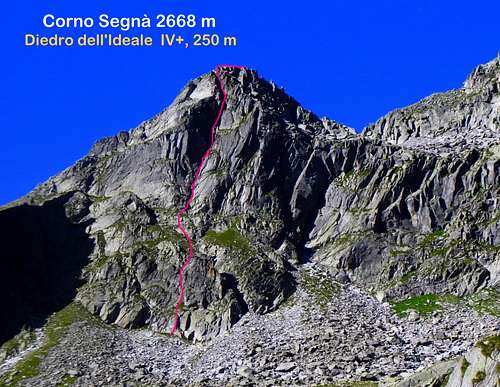
Diedro dell’Ideale report - UIAA scale
Summit altitude: 2668 m
Difficulty: IV+ max - UIAA scale
Climbing length: 250 m
Equipment: equipped belays, 1 peg each length, good possibility to integrate with mobile protections
Exposure: East
Starting point: Cornisello lakes parking lot
First ascent: G. Bestetti, T. Beltrami, A. Beltrami 7-7-2015
Pleasant trad route not too demanding, which follows an obvious corner cutting the East face of the peak. The rock is the characteristic kind of granite named "tonalite", of good quality, and the route is advisable and located in an alpine setting of great beauty.Approach - From the car park cross the bridge and walk along the gravel road skirting the Cornisello lakes; arrived near the Malga Cornisello leave the road and take to the right the path SAT 239 towards Lago della Vedretta (signpost). After about 15 minutes of ascent leave this path and go left, rising without a trace the grassy slopes on the left. After reaching the summit of the hill traverse slightly downhill to the left, heading for the wall cut from the large open dihedral now well in sight. Cross towards the left a slightly ascending slope of big blocks, heading to the left one of two parallel dihedral at the base of the wall. Attack on a nice well carved wall to the left of the dihedral (hole with rope lanyard). Cairn.


Report
L1 - Climb the nice wall and belay below a dihedral-chimney, III, 30 m.
L2 - Climb the dihedral chimney or, better, the beautiful wall on the left of the chimney - most difficult but most attractive - and belay at the beginning of a grass and rock slope, IV+ or III inside the chimney, 30 m.
L3 - Up the slope for about 30 meters and reach a terrace at the base of a little wall (transfer pitch) .


L4 - Climb the wall above the stance, then follow a gully to reach the stance at the base of the wide regular dihedral, which provides the directive of the second half of the route, III, 30 m.
L5 - From the stance move to the left to take the dihedral (1 peg) and climb it, IV, 30 m.
L6 - Continue along the beautiful dihedral, IV+, 28 m.
L7 - Again along the dihedral, IV+, 30 m.
L8 - Climb up a groove, then turn to right and follow the ridge getting the double summit, III, then I, 30 m.


Descent: from the summit reach the last anchor and from here abseil down along the same route (the abseils max 30 meters long).
Relazione Diedro dell’Ideale – scala UIAA
Quota sommitale: 2668 m
Difficoltà: IV+ max - scala UIAA
Lunghezza arrampicata: 250 m
Attrezzatura: soste attrezzate, 1 chiodo per tiro, buone possibilità di integrazione con protezioni mobili
Esposizione: Est
Punto di partenza: parcheggio dei laghi di Cornisello
Prima salita: G. Bestetti, T. Beltrami, A. Beltrami 7-7-2015
Piacevole itinerario trad non troppo impegnativo, segue un evidente diedro che incide la parete Est di Cima Segnà. La roccia è il caratteristico tipo di granito del gruppo della Presanella, denominato "tonalite", di buona qualità. La via è consigliabile e situata in un contesto alpino di grande bellezza.
Avvicinamento - Dal parcheggio oltrepassare il ponte e percorrere la strada sterrata che costeggia i Laghi di Cornisello. Arrivati nei pressi della Malga Cornisello abbandonare la strada e prendere a destra il sentiero SAT 239 in direzione Lago della Vedretta (segnavia). Dopo circa 15 minuti di salita abbandonare questo sentiero e proseguire a sinistra, risalendo senza traccia (ometti) i pendii erbosi sulla sinistra. Raggiunta la sommità del pendio di erbe e rocce si traversa in leggera discesa verso sinistra, dirigendosi verso la parete incisa dal grande diedro aperto ormai ben in vista. Traversare verso sinistra in leggera salita un pendio di grossi blocchi, dirigendosi verso sinistra uno dei due diedri paralleli alla base della parete. Attacco su bella parete ben intagliata a sinistra del diedro (foro con cordino di corda). Ometto.
Rapporto
L1 - Salire la bella parete e sostare sotto un diedro-camino, III, 30 m.
L2 - Salire il camino diedro o meglio la bella parete a sinistra del camino - più difficile ma più attraente - e sostare all'inizio di un pendio di erba e roccia, IV+ o III all'interno del camino, 30 m.
L3 - Risalire il pendio per circa 30 metri e raggiungere un terrazzino alla base di un muretto (tiro di trasferimento).
L4 - Risalire la parete sopra la sosta, quindi seguire un canalino per raggiungere la sosta alla base dell'ampio e regolare diedro, che costituisce la direttiva della seconda metà della via, III, 30 m.
L5 - Dalla postazione spostarsi a sinistra per prendere il diedro (1 chiodo) e salirlo, IV, 30 m.
L6 - Proseguire lungo il bel diedro, IV+, 28 m.
L7 - Sempre lungo il diedro, IV+, 30 m.
L8 - Risalire un canalino, poi andarea verso destra e seguire la cresta raggiungendo la doppia vetta, III, poi I, 30 m.
Discesa: dalla vetta ritornare all'ultima sosta e da qui scendere lungo lo stesso itinerario (lunghezza massima delle doppie 30 metri).
Essential gear
A single 60 m rope is enough for abseiling, alternatively 2x50 ropes, helmet, a full set of friends is essential along the pitches (only the belays are equipped).
Per la discesa è sufficiente una sola corda da 60 m, in alternativa corde 2x50, casco, indispensabile il set completo di friends lungo i tiri (sono attrezzate solo le soste). Qualche chiodo lungo i tiri.
Red Tape

There are no particular restriction in climbing and hiking. Corno Segnà is located within Parco Naturale Adamello-Brenta, the largest protected area in Trentino, established in the year 1967. It's located in Western Trentino and with its 620.51 square kilometers includes the mountain groups of Adamello, Presanella and Brenta Dolomites, separated by Val Rendena.
Non ci sono restrizioni particolari per l'arrampicata e l'escursionismo. Il Corno Segnà si trova all'interno del Parco Naturale Adamello-Brenta, la più vasta area protetta del Trentino, istituito nel 1967. Si trova nel Trentino occidentale e con i suoi 620,51 chilometri quadrati comprende i gruppi montuosi dell'Adamello e della Presanella, separati dalle Dolomiti di Brenta per mezzo della Val Rendena.
When to Climb
The best period to climb goes from middle June to middle September
Il periodo migliore per arrampicare va da metà giugno a metà settembre
Where to stay
Several possibilities of accomodation in Val Rendena.
Numerose possibilità di soggiorno in Val Rendena.
Huts: Rifugio Nambrone - Rifugio Cornisello
Meteo
METEO TRENTINO
DOLOMITI METEO - TRENTINO
Guidebooks and maps
-Guidebooks
"Presanella" - Guida dei Monti d'Italia CAI-TCI - Dante Ongari, 1978
- Maps
"Adamello - Presanella" - Tabacco scala 1:25000