We've been keen on a return to the Grand Canyon for a while now. It’s on my list of Five best dayhikes of a lifetime and is a place my wife and I both love to visit as often as we can.
As 2010 rolled around, the tea leaves made promising patterns, the entrails fell encouragingly, the oracle pronounced favourably and the stars finally aligned for the middle of May. Flights were booked, accommodation arranged and we would even be accompanied by Vancouver Islander junior and Mrs VIJ for three days of Rim-to-Rim-to-Rim hiking.
The Pueblo Massif from Whitehorse Butte. Desert peakbagging at its finest
Perhaps oddly for a resident of an island in the verdant, rain-soaked Pacific Northwest (or Southwest from our perspective), I’ve been interested for some time in the mountains of the Alvord Desert area of southeastern Oregon and the adjacent area of Nevada. May is iffy weather time on the Island, so it made sense for me to drive down, get some lovely warm early season spring hiking in and tick off a few of my southern objectives en route.
So off I went on my solitary but merry way on May 3rd with the family due to arrive in Las Vegas on the 12th.
May 5th, Pueblo Mountain, OR
Warm weather spring hiking did I say? I’d barely managed to get over the Government Camp Pass in a snowstorm on the way down and there was a nice layer of ice over everything in Denio (or “Dead n’ Alive” as I soon began to call it) at 7 am on the morning of May 5th. Cold weather gear went into the pack and I was at the top of the infamous approach road at the top of the Arizona Creek Valley and the bottom of the North Ridge Route by about 9.
Pueblo and West Pueblo Mountains from Long Hollow Pass
I thought the road was quite OK. Narrow certainly and I wouldn’t have fancied meeting another vehicle along the way but evenly surfaced and with nothing much in the way of obstacles. Beyond the top of the approach valley, however, it soon got boggy and traction became an issue. So, since I was alone and it didn’t seem likely that anyone else would be coming this way, I gave up on plans for the West Face Route and returned to the North Ridge and the guarantee of being able to drive out of there later.
Gear up and off I went at 9.20 in cloudy, cold weather.
Following Dennis Poulin’s excellent North Ridge description, I flogged 300 metres up the initial grass and sagebrush slopes, bypassed the 7,500 foot highpoint on the ridge to the west (bit of unpleasant-ish sidehilling on talus here) and dropped into the broad saddle below the continuation of the ridge all in about an hour from the start. Out of the shelter of the ridge a stiff wind cooled things off even more and I began to put layers on rather than take them off. The occasional snow squall subtracted even more from the less than spring-like conditions.
Approach road
Bottom of north ridge
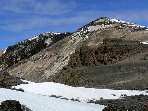
False summit from N ridge saddle
North slopes/ridge
From the saddle I picked a line to the west of the ridge crest mostly on snow and intersected the ridge once more just below the first false summit, finally arriving there at about 11.30 in a full-on snow storm/gale.
From the false summit it’s reportedly a pleasant walk up the remainder of the ridge to the summit plateau and to the true summit beyond. Today it was a head down trudge in the teeth of the wind. Certainly not the conditions in which to saunter along and I hit the summit only 15 minutes past the first false summit in an effort to keep warm. With the wind chill, I estimated the temperature on the summit at -15C (5F). At least it stopped snowing and I got some spectacular all-round views of what I could still appreciate as a truly lovely area.
Spring (?!) conditions on the summit of Pueblo Mountain in SE Oregon. High winds and freezing temperatures.
A quick search for summit register, survey monument etc proved futile before I settled into the best shelter I could find just south of the summit cairn for lunch and photos.
Even wearing every stitch of clothing I’d brought with me – which included 3 fleeces and a shell – I still couldn’t stave off net heat loss and, with teeth chattering, I got moving again at about 12.20.
Summit ridge
Summit plateau
Summit view east
West Pueblo Mountain
Keen to get as low as possible as quickly as possible in conditions that were deteriorating by the minute, I dropped off the first summit northwest in order to intersect some roads I could see down there. The map told me they led to the continuation of the road to Ten Cent Meadows and this, indeed, proved to be the case. Running down friendly snow and then grass slopes I hit the first road 25 minutes from the false summit and the Ten Cent Meadows road shortly after. I then simply walked around the foot of the north ridge and back to the truck well before 2 pm.
“That” road proved a bit more of a handful going down. Debris or simply the angle of the road tipped the truck over towards the drop off on a number of occasions. Probably wasn't that bad but it felt alarming at the time.
May 6th, Whitehorse Butte, OR
Off at about 8 am on another frigid morning but at least sunny and with no wind.
calebEOC’s immaculate SP instructions got me to the Willow Creek Basin off Whitehorse Ranch Road in next to no time.
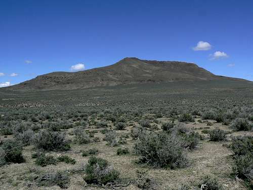
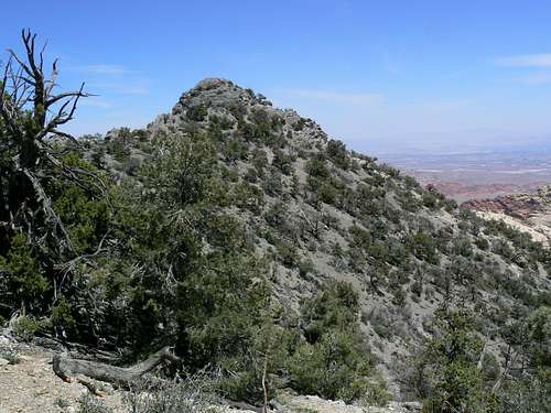
Whitehorse Butte
As caleb says “Whitehorse Butte does not have a trailhead let alone a trail so find a line up the mountain you like”. I found such a line and parked after driving about 9 km south from Whitehorse Ranch Road at N42 14.206 W118 13.752.
Heading across lovely open desert, I aimed initially for the west side of the summit escarpment hitting it about N42 15.059 W118 13.076. From there I was able to choose any entertaining scrambling option I liked as I made my way around the ridge northeast to the large summit cairn at about 11.30 am. By this time the day had turned balmy and I was able to enjoy the views at leisure.
Whitehorse Butte summit escarpment
And what views. Except for Whitehorse Ranch, nothing but empty desert all around. The Trout Mountains, Pueblo, Steens and more framed the view from south through west to north whilst to the east Whitehorse Canyon provided a nice counterpoint to all that snowy high ground.
Whitehorse Butte start
Desert floor below Whitehorse Butte
Southwest ridge
Whitehorse Butte USGS Monument
Perhaps the most spectacular aspect of the view, however, was what I couldn’t see. I estimated the radius of my field of view from the summit of Whitehorse Butte at about 60 km. I had driven 40 km on gravel from pavement to the west just to reach the turnoff for Willow Creek Road, leaving a long dust trail behind me all the way. Similar gravel roads radiate off in all directions across the desert. And yet in the ~ 11,000 sq kilometers of desert I was looking at from the summit of Whitehorse Butte I saw not one sign of another vehicle’s passage!
The hour was early and the route quick so I spent a long hour wandering up and down the length of the summit escarpment (finding a lower summit with survey tripod and monument along the way), taking photos and enjoying a leisurely and sun-warmed lunch.
Steens Mountain
Pueblo Mountain
Whitehorse Canyon
Heading down finally I picked a line through the escarpment “cliffs” starting from just east of the large cairn on the true summit and then made a beeline SSW towards the tiny dot in the distance that, happily, turned out to be my truck, arriving at about 2 pm.
May 7th, Buckskin Mountain, NV
I have to be honest here. At the outset of the day, I’d never even heard of Buckskin, let alone intended to climb it. My objective for the day was Granite Peak. The weather conditions to this point should have warned me that this was an unlikely objective in terms of access at this time of year, but I went anyway.
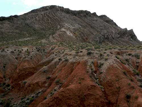
Buckskin Mountain
To no-one’s real surprise, I’m sure, I found the “Buckskin Canyon Road” impassable well below Windy Gap and prepared to turn back disappointed. I did, however, not want to write off the day and an attractive ridgeline directly above the road to the east offered exercise and potential views. The map revealed that the snow capped summit due north of the ridge was “Buckskin Mountain”. “I wonder if they connect,” I thought. If I couldn’t find a way through the cliffs to the ridge crest, it appeared that I could simply traverse north to where they petered out and investigate further from there.
So, armed with such stunningly detailed preparation as the sum total of foreknowledge of the route, I found a convenient spot to park at the bottom of the switchbacks on FR084 (aka Buckskin Canyon Road), geared up and set off in sunny weather at 10.30 am.
Initially I walked the road for ~ 2 km/~ 1.2 miles before finding a shallow grassy gully at N41 46.259 W117 33.474 which led due north up the hillside to the sub ridge above.
Buckskin from start point on FR084
Start point below west face
Buckskin west face
South slopes
I climbed the gully north for 100-200 metres before gradually swinging round to the west. The ridge wasn’t that well defined so it was a question of making my best choice of a route up grass, sagebrush and talus aiming directly for the foot of the distinctive “cockscomb” green lichen stained rhyolite buttress that I could see above. It was about 500 metres of map distance and 300 metres/1,000 feet vertical from the road right to the foot of the buttress.
Once at the base of the cliffs I turned left/northeast up a ramp at the base of the cliffs. Seeing no obvious weakness in the cliff line above, I made a rising traverse 500 metres map distance across steep slopes to the point where the cliffs tapered into the ridge crest. There was some exposure, lots of loose rock and some Class 3 here and there.
Once on the crest I discovered a gentle east side of the mountain complete with snow covered roads! I checked the map to find that these originate at Windy Gap and, as I discovered later, have a lot to do with the extensive mining history of the area.
At this point, however, my main interest was if the point I was on would connect with the summit of Buckskin and I was delighted to discover that it did.
Main summit from south summit
Buckskin Mountain summit
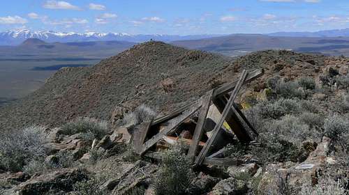
Mining claim on summit
Buckskin from near Windy Gap
From the point at which I had intersected the ridge crest, I continued north and then northwest on the snow covered old roads towards the summit and eventually simply climbed snow slopes directly over the south summit to the main summit just beyond at 2 pm.
Granite Peak and the Santa Rosa Range from Buckskin Mountain
By now the day had turned cloudy and cool but views were still spectacular and included my erstwhile objective, Granite Peak, and the rest of the Santa Rosa Range to the south. A mineral claim was evident just below what appeared be a predominantly limestone summit. All in all, not too shabby for a day based entirely on happenstance.
Bilk Creek Mountains, Trout Creek Mountains and the Pueblo Mountain massif
Summit View East from Buckskin Mountain
The old roads down to Windy Gap served to avoid what might have been a nasty and loose side-hill descent and from there it was 5 km down FR084 to the truck at 4.30 pm.
May 10th, North Peak, NV
After Buckskin Mountain it was time to head further south. Armed with Courtney Purcell’s Rambles and Scrambles Around Las Vegas and redsplashman23’s SP pages, I figured I’d sample some hot weather hiking around Vegas while waiting for the family to arrive.
North Peak from Red Rocks summit road sounded like a nice half day objective and I duly headed that way on a pleasantly warm morning.
North Peak
Directions from Courtney/rsm23 were right on and I soon found myself bumping up the dirt road from Willow Springs towards the pass at Red Rocks Summit.
About half way up I encountered a rather deep washout. Not knowing how often folk drive up here and without a “spotter” on board, I figured I’d better leave the truck at this point rather than get stuck. In fact, it was a very pleasant stroll up to the pass with opportunities to look around that I wouldn’t have had if driving.
In any event, I got to the pass in about an hour and took to the trail up North Peak at the very civilized hour of noon.
The trail to the summit was well marked, including the junction with the route to Bridge Peak, and I was on top less than an hour later to stunning views over this very special area.
It turned cold and windy on top but with the change came improved air quality and not only the whole northern segment of Red Rocks - with Bridge Mountain and Mt Wilson particularly prominent - but also downtown Vegas and Lake Mead were in clear and uninterrupted view.
Red Rocks Summit road
N Peak sandstone summit
Bridge Mountain
Mount Wilson
The summit was equipped with a register in a, some might say quintessentially Nevadan, receptacle – an ammunition box. The register confirmed that North is a frequently visited and popular destination.
Half an hour on top sufficed for photos and lunch and, with that cold wind blowing ever stronger, I set off down at 1.30 and reached my truck at 3.15.
Reading the guidebook later that day I discovered that most people regard the sandstone promontory 500 metres to the northeast of the limestone summit I was on as the “true” summit of North Peak. First time I’ve ever encountered a lower “true summit”. Oh well, I’ll just have to go back and bag that one too.
May 11th, Charleston Peak, NV
Charleston Peak. Echo Canyon
Every trip has one component that turns out to be a bust and, unfortunately, Charleston turned out to be it in this case.
I should have expected little else. The high winds that blew in while I was on top of North Peak yesterday were well established by the time I got to the South Loop trailhead at about 6.45 am to find it fenced off and not yet open for the season. So I drove round to the alternate “Echo” trailhead and walked 20-30 minutes back over the hill from there.
Heading up finally from the Cathedral Rock campground I ran into snow almost immediately and soon lost the trail following the boot tracks of equally misinformed folk.
The GPS got me back on track and enough path appeared now and again to assure me that I was going the right way. However, on bullet hard snow and without axe and crampons, matters got hairy on the climb up to the ridgeline. With the wind literally howling by this time and considering what it would be like several thousand feet higher up, out on the open ridge, I had the good sense to turn round and (largely) write off the day.
May 12th, Northshore Peak, NV
Lake Mead was next on my “sampler” Las Vegas area list and friendly Northshore Peak my chosen objective.
Redsplashman23 was spot on, as usual, with the directions and I was parked and ready for an alpine start of 11 am.
Northshore Peak
There’s no trail up Northshore, nor is one needed. You can see the whole thing in front of you across the road from the car. Unless it’s foggy, leave the GPS at home.
From the start point, I just walked across the desert, invented a scrambly line up to the east ridge at a convenient spot and simply followed it up to the summit in about an hour, conjuring up options as I went.
NE ridge cactus flower
NE ridge Class 3 gap
Northshore Peak summit
A knife edge provided entertainment at one point and led almost to the documented Class 3 downclimb. There were newly blooming cactus and other brief lived desert flora to admire and views all the way up. A quick route but entirely enjoyable.
The summit had a cairn, a register and, for the moment, a little puppet to keep it company.
Northshore Peak view south
Northshore Peak view north
Northshore Peak view SW
The all round views were tremendous, the weather benign and the company (me) unanimous in declaring Northshore a great little mountain with which to finish off the solo portion of my trip.
After a lovely lunch, I hiked happily down the mountain looking forward eagerly to my family’s arrival in a few hours and already anticipating a great time in the Grand Canyon. But that, as they say, is another story…………
Parents refers to a larger category under which an object falls. For example, theAconcagua mountain page has the 'Aconcagua Group' and the 'Seven Summits' asparents and is a parent itself to many routes, photos, and Trip Reports.

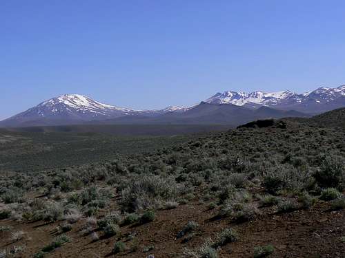
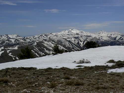

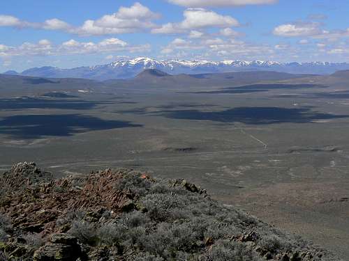 The Pueblo Massif from Whitehorse Butte. Desert peakbagging at its finest
 Approach road
 Bottom of north ridge
 False summit from N ridge saddle
 North slopes/ridge
 Summit ridge
 Summit plateau
 Summit view east
 West Pueblo Mountain
 Whitehorse Butte start
 Desert floor below Whitehorse Butte
 Southwest ridge
 Whitehorse Butte USGS Monument
 Steens Mountain
 Pueblo Mountain
 Whitehorse Canyon
 Buckskin from start point on FR084
 Start point below west face
 Buckskin west face
 South slopes
 Main summit from south summit
 Buckskin Mountain summit
 Mining claim on summit
 Buckskin from near Windy Gap
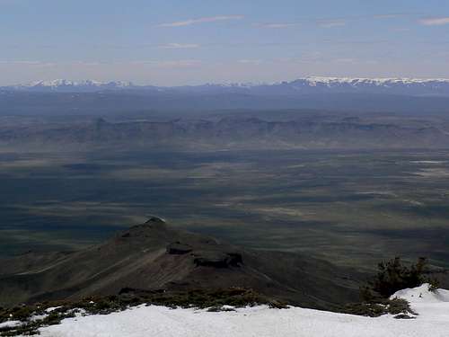 Bilk Creek Mountains, Trout Creek Mountains and the Pueblo Mountain massif
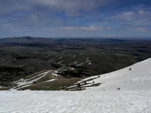 Summit View East from Buckskin Mountain
 Red Rocks Summit road
 N Peak sandstone summit
 Bridge Mountain
 Mount Wilson
 NE ridge cactus flower
 NE ridge Class 3 gap
 Northshore Peak summit
 Northshore Peak view south
 Northshore Peak view north
 Northshore Peak view SW