
-
 2602 Hits
-
 79.04% Score
-
 10 Votes
|
|
Route |
|---|---|
|
|
34.34500°N / 117.839°W |
|
|
Hiking |
|
|
Summer |
|
|
Less than two hours |
|
|
Trail |
|
|
Overview
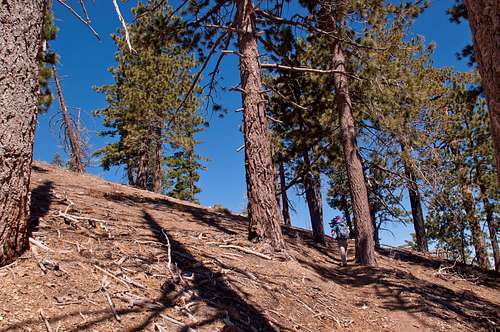
Mount Islip is located high above the Crystal Lake Recreation area in the San Gabriel Mountains and commands fine views to the Mojave Desert to the north, the San Gabriel Mountain Front Range to the west, the canyon of then North Fork of the San Gabriel River to the south, and the High Country to the east. The most common approach is via Windy Gap and the East Ridge on a well-maintained trail. Due to the newly re-opened SR39 to Crystal Lake and the open SR2, this area once again becomes very popular among outdoor enthusiasts. There are several approaches to Windy Gap, the shortest of which is via a steep gully to the north. This route description illustrates the route from SR2 to Windy Gap and further to the summit of Mount Islip via the trail along its east ridge.
Overall, this route totals to about 1.2 miles to the summit with an elevation gain of about 1,000 feet.

|
|---|
Getting There
If you are coming from the west on the Angeles Crest Highway (SR2) the trailhead is 41.6 miles from the intersection of the 210 freeway and the SR2. There is a small parking area on the north side of SR2 at mileage marker 66.37.
Description
Across the parking on the north side of SR2 at mileage marker 66.37 you will see a steep gully with a defined use trail on its east side (~7,250'). Cross the street carefully and head up the steep use trail. A vertical metal pipe at the bottom of the gully will assure you to be at the right spot. You will ascend steeply in about 0.25 miles to Windy Gap at around 7,580'. From there you have fabulous views to the south over the Crystal Lake area. To the right (northwest) you will see Mount Islip. A multitude of trail leads from Windy Gap in several direction. Take the one that says "Mount Islip". Be sure not to take the Pacific Crest Trail that leads in the same direction (but below the Islip trail) to Little Jimmy Campground and further to Islip saddle. The Islip trail roughly leads up the east ridge of Mount Islip. The trail switchbacks a few times until it reaches an intersection with a trail after about 0,4 miles that leads down to Little Jimmy Campground (~7,725). Turn left and continue uphill. Be sure to turn right at this spot on your way down. From there the trail ascends at a moderate angle and eventually crosses the east ridge to the south side. You will hike past the summit of Mount Islip before the trail turns sharply right at around 1 mile, ascends the south side of Mount Islip, passes an old stone ruin, and reaches the summit at around 1.2 miles. Enjoy the 360 degree views and ponder your options for the return.
Instead of taking the trail (with some switchbacks), one can also hike directly on the east ridge to the summit. Although certainly scenic and easy I would encourage and ask everybody to stay on the (short) trail to protect the hillsides.
| Approach Canyon | Islip Trail |
|---|---|
 |
 |
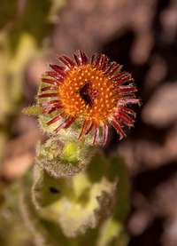
Wildflowers
Some wildflowers seen along the hike…
| Red-Rayed Hulsea | Grinnell's Beardtongue | Fremont's Monkeyflower |
|---|---|---|
 |
 |
 |
Red Tape
Don’t forget to display your Adventure Pass on your parked vehicle.