Introduction
![La Maroma]() La Maroma seen from the east La Maroma seen from the east |
So we really are in Andalucía now and the skies of southern Spain are shining brightly blue. It’s 8 a.m. on a Monday morning in early May and we are wondering what we will do today. Yesterday was one of those horrible travel days. The flight from Frankfurt to Malaga had been postponed from reasonable 10 a.m. to 6 p.m. and thanks to the usual delays at Frankfurt we had arrived only at 9:30 p.m. To claim our baggage took another 45 minutes, renting a car was quick but then we got lost in the underground parking garage. There is second rental car office on the lowest deck and getting down there turned out to be quite a journey in itself. But finally we got the keys, found the car (in a completely different place than indicated) and took on the 65km journey to Nerja in the east.
There the office of our apartment complex was closed, but our directions told us to pick up the keys in a hotel down the street. Down the street was no hotel but a Moroccan restaurant. The waiter, however, knew the hotel, directed us there and finally we received our keys. Another half hour later the baggage was unpacked and we sank into our beds. The clock struck 2 a.m.
So now we are planning the day. We need to pick ups some groceries first but then we want to get out and climb something. Something close to Nerja, something with a reasonable elevation gain. We don’t want to start with the most serious climb. And it shouldn’t take too long.
Judith surprises me with “let’s climb La Maroma”. It’s close by and the elevation gain is 800m. But it’s also a black tour in our guidebook. Black usually means difficult, long or exposed. Maybe all three together. But since I’m the unreasonable one of us I agree easily and the destination is settled. La Maroma is Spain’s westernmost 2000er and since only on Iceland you can find a higher mountain further west La Maroma is the last 2000er of continental Europe.
Andalucia
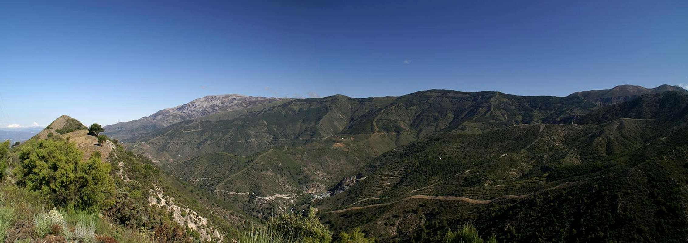
Sierra de Tejeda with La Maroma to the left |
After an hour in the closest grocery store, after storing everything in cupboards and fridge, after packing the backpack we finally start the car and head out of town. We are astonished how green everything is. There are the obvious concrete blocks in the towns along the coast but the backcountry is completely different. Little villages are nested among the slopes of rocky limestone mountains and everything is covered with trees and bushes. There are millions of flowers blooming on those slopes – very beautiful.
The mountains don’t seem to be high but they form a huge barrier between the coast and the high plains further inland. This is the Sierra de Almijara as Judith reads from the guidebook, a limestone range reaching little over 1800m. To its west there is a smaller range, the Sierra de Tejeda, and this is where we are headed. La Maroma is its highest peak and our roadmap tells us that there is not much more to the range than this one big mountain.
We have to drive all around one half of this mountain barrier. Our trailhead is on the other side near Alhama de Granada. Roads are crowded and we wonder if our climb is really that close to our vacation home as we thought. Heading up into the mountains we look in wonder at a huge, broad backed mountain, which rises out of the coastal plain steeply to its wide summit. It takes quite a while until we realize that this is our destination. From down here it looks very far away. We circle the mountain and when we finally reach the inland plains traffic subsides. We quickly reach the outskirts of Alhama where a dirt road leads us to our trailhead. Rushing across it our car quickly attains a thick layer of dust and nobody would realize that this car looked brand new half a day ago.
A Long Start
We park the car in the shade and don’t waste time and quickly head out of the parking lot. The first stretch of the climb follows a dirt road which winds through the pine forest. There are wild peonies everywhere and I take a break or two to shoot some photos. Apart from the flora the hike is boring. A wide road, lots of trees, no views but hundreds of flies trying to fly into mouth, nose or ears. We try to move quickly through the clouds of insects.
An intersection takes us on a narrower path, getting narrower still and finally starting to climb more steeply into the vicinity of a ridge. Every now and then we head out of the forest and while the first views are far from breathtaking we finally see something, for instance our destination! A sharp peak rises above the valley which we have been following so far and we gather that this must be a side summit of La Maroma. The flies also seem to get bored and leave us alone. In a turn of the path we suddenly find ourselves on the ridge. A few steps and we head back under the trees. Some 500m later finally they retreat and we find ourselves on a small platform above our ridge. Though we have been hiking for only one hour yet it’s 1 p.m. already and time for lunch. Yet another delay on our way to La Maroma!
![Sierra de Jatar]() Sierra de Jatar Sierra de Jatar | ![First views]() Alhama Plain Alhama Plain | ![Karst landscape]() Karst landscape Karst landscape |
After the break we head on and upwards. The path leaves the ridge again and follows a valley which ends beneath the east face of the mountain. If that’s our route it’s going to be a serious scramble. However, we hike along on the higher slopes and there is still hope for an easier alternative. Indeed, we climb higher on the slope and suddenly head across a sloped plateau towards a notch beneath the mountain. The ridge, which our path accompanies, has built up into massive faces, the Salto del Caballo, around which big clouds of large ravens fly.
![On the traverse]() Traverse Traverse | ![Rock formation]() Rock formation Rock formation | ![El Salto del Caballo]() Salto del Caballo Salto del Caballo |
A steep section brings us to the notch and suddenly we can see the whole summit plateau of La Maroma, a huge sloped karst plain, complete with crevices and dolines. Right beneath the summit a big patch of dwarf pines seems to bar the way – it looks like we will be in for some bush-whacking fun.
A Matter of Equilibrium
![La Maroma]() The karst summit
The karst summit
For a moment we are at a loss – any signs of the path have vanished and out here on the plateau it is difficult to spot them again. Instead of heading for the summit directly we turn southwards, following the indication of a path towards a saddle directly above the south face of the mountain. There a beautiful view of the face awaits us – eastwards a rocky side summit, westwards a number of formations which hover vertically above the face. Moreover, a trodden path leads across these rocky formations – the route to the summit.
![South face rocks]() South face rocks South face rocks | ![Monkey faced overhang]() Monkey face profile Monkey face profile | ![Keeping the balance]() Keeping balance Keeping balance |
Naturally I take the usual time shooting photos of the formations and almost lose Judith from my sight. But then she turns and picks up her camera – a rare occasion – usually it needs my prodding to make her take photos. I follow her and turn around, immediately understanding the reason for her photo. I had been stand right beside a face-like overhang, which towers above the face. I take my shot in turn – not the last of the day.
![Lizard with heavy plating]() Lizard Lizard | ![Ibex kids]() Ibex kids Ibex kids |
The path winds through the rocks like through a labyrinth – a real maze. Every now and then we seem to get lost but spot the next marker just in time. Lizards with a plate-like amour scuttle away – and then we meet our first ibexes. Iberian Ibexes have different horns than the alpine ones but otherwise look quite alike their northern brethren. As usual we run across a mother with her kids, half-growns. The path heads up the La Maroma slope directly and though it is barely distinguishable the destination is right in sight. There is a large pillar on the summit which is the only way mark in an otherwise featureless landscape.
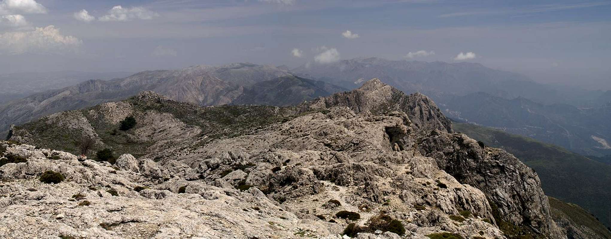
Sierra de Tejeda as seen from La Maroma's summit |
Closing in on it we pass a couple of stone circles against the wind, which can be quite fierce on this exposed plateau. Today it isn’t. In fact there is barely a breeze and millions of little bugs are dancing around us, most of them deciding to visit Judith’s white shirt. I with my striped one seem to be safe from them. I climb the summit pillar and only now I have a view of more than the La Maroma plateau. Up close, to the east, we look across the Sierra de Almijara and in the background the snow-covered peaks of the Sierra Nevada loom. Unfortunately it’s hazy and the views are far from perfect.
![Famous last steps]() Last steps Last steps | ![Summit shot]() Summit hero Summit hero |
The Return Ticket
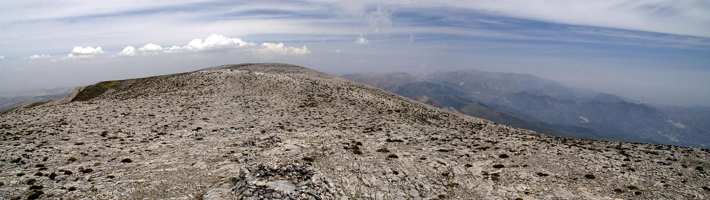
Looking across the La Maroma summit plateau from the pillar |
In the guidebook the route heads on and descends the mountain in south-westerly direction. Since it is already late we turn around and retrace our steps. After a few steps we lose the path on the featureless plateau and are happy to carry a GPS system with a map. After several hundred meters we are back on track and head for the south face rock formations. From up here they look even more impressive and I stop to take picture after picture. One more Ibex crosses our path – a young male – and later across a chasm we see a couple of kids. Again lizards hurry on by and finally we’re back at the overhanging face. From up close it looks a bit like a monkey face – seen in profile.
![Male Ibex]() Male Ibex Male Ibex | ![Back at the monkey face]() Back at the monkey face Back at the monkey face | ![Posing Lizard]() Posing lizard Posing lizard |
Then we’re back at the saddle and take one last look across the plateau towards La Maroma. A descent underneath El Salto del Caballo, then a long traverse across the sloped plateau – one last look from the east ridge and we plunge into the forest. Of course the flies are back – and since we have become quite smelly they are more obnoxious than ever. Somehow they decide to go for our body openings and keeping them away from mouth, nose and ears takes quite a windmill-like effort from our part. I only stop twice for some pictures of peonies and then we’re back on the dirt road. A couple strolls in front of us and when we overtake them they turn out to be fellow Germans. “How long does it take to the summit?” – “2 ½ hours for us – but you will take twice the time” – I suppress the second part of the sentence. Two more kilometers and we are back at our car, which by now is parked in the open sun. Boots off, air condition on – in a minute we are on our way back to the apartment. Sixty minutes later we are back with Europe’s westernmost 2000er under our belt. And if you ask me – I think it is Europe’s southernmost one as well…
![Above the south face]() South face South face | ![Last glimpse of La Maroma]() Last glimpse Last glimpse | ![Eastern south face]() South face South face |


Comments
Post a Comment