
-
 17667 Hits
-
 74.92% Score
-
 5 Votes
|
|
Route |
|---|---|
|
|
39.63390°N / 105.8169°W |
|
|
Hike |
|
|
Half a day |
|
|
Class 1 |
|
|
Overview
This is the standard route on Grays Peak, and is recommended by Colorado Fourteeners Initiative as the peak's most environmentally-sound route.
Distance, Round-trip: 8.0 miles
Elevation Gain: 3,040 feet
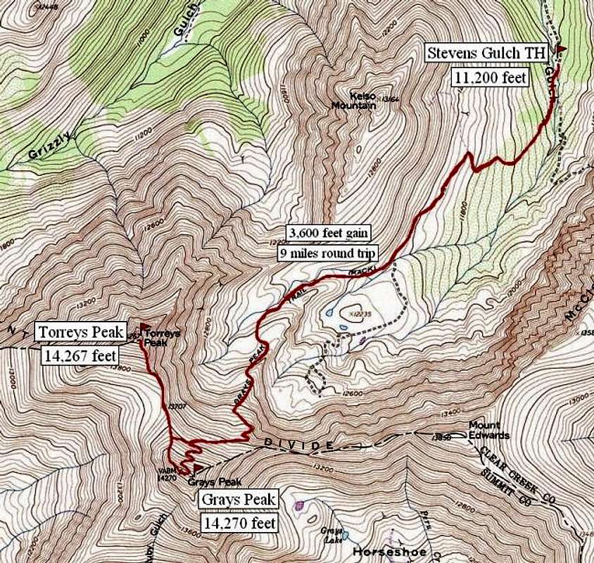
The topo above, submitted by odysseus, shows another popular option, which is combining a hike of Grays Peak with its neighbor fourteener, Torreys Peak.
Approach
Start at the Stevens Gulch Trailhead, which can be accessed from I-70 at the Bakerville exit (Exit 221). The drive up the dirt road can be a bumpy one, and I would recommend a 4-wheel drive or at least a high-clearance vehicle. In winter, this road is closed, so you can plan on adding an extra six miles to your trip. The road splits at the Grizzly Gulch Trailhead. Be sure to stay left as you continue uphill to get to the Stevens Gulch Trailhead. You will reach the trailhead after three miles. The hike begins at 11,230 feet, about at timberline in a very scenic valley. Follow a wooden foot-bridge across the creek, and begin your trek up Stevens Gulch.
 |
Route Description
The Grays Peak Trail is easy to follow upward through Stevens Gulch. In summer this is a crowded route, and it is best to start early to avoid crowds (and thunderstorms!). There is often a beautiful array of wildflowers, and do not be surprised to encounter some mountain goats along the way!
This trail is obvious the whole way. There are a couple forks in the trail, however, as you near the Grays-Torreys saddle. Stay to the left, and continue switch-backing your way to the highest point on the Continental Divide. The view is worth the effort!
 |  |  |  |
Essential Gear
Water, camera, good hiking shoes.
In winter, snowshoes and crampons are recommended, as you will encounter large snow drifts and icy patches.