
-
 3239 Hits
-
 81.84% Score
-
 14 Votes
|
|
Mountain/Rock |
|---|---|
|
|
46.45459°N / 15.21482°E |
|
|
Hiking |
|
|
Spring, Summer, Fall, Winter |
|
|
3294 ft / 1004 m |
|
|
Topographic isolation: 0.4 km
Nearest higher peak: Vavkanov vrh, 1271 m
Prominence: 35 m
![The steep southern hillside of Križevski vrh]()
View from southKriževski vrh is a summit in Pohorje. It’s not really significant. Actually it’s only a minor summit on southwest ridge of Črni vrh, 3.8 km far from the main summit, and 1.8 km far from the village Mislinja where the ridge has its end.
There are two reasons why I created a page for this summit: because of the the nice flowers on the hill and because there is a peculiar geographical/geological spot at the foot of the hill that I try to describe.
‘Križ’ in the root of the word ‘Križevski’ means ‘Cross’, but more likely it is in connection with a crucifix.
The hill is built of the common gneiss. It doesn’t have sharp shapes. Its summit is rounded and covered with dense spruce forest, so from the very top there is no panoramic view. Nevertheless many of its hillsides are meadows with good views. The hillsides are steep - Križevski vrh is surrounded with deep valleys from east, from south and from west.
![The St Leonard church in Mislinja]()
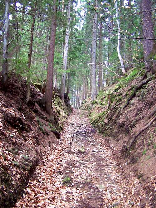
The St Leonard church in Mislinja![Trail leading from Mislinja to Križevski vrh]()
The trailFrom Mislinja (620 m)
2.5 km, 1 hour. Altitude difference: 385 m
Access to the trailhead:
From Ljubljana: Take the A1 highway to the direction of Maribor. At Žalec you maust leave the highway and drive 23 km to north to Velenje. From Velenje it’s a further 13 km driving and you reach Mislinja. You will see a beautiful church after entering the city. 100 meter after the church take the first street to the right, and then cross the river. A fewhundreds meter further you reach the foot of the mountain.
Route description:
This route goes north-northeast from Mislinja. The route is sometimes only a tourist path, while sometimes it is along local macadam roads. In the first 2 kilometres the route crosses a spruce forest, then some meadows. Don’t be surprised: it crosses also the courts of 3 farmhouses. After 2 km of walk – at the 3rd farmhouse - you reach Križevski vrh (1004 m). The marked path don’t go up to its peak but go around it (west to it), following the macadam road. You can ascend the summit either from south, from the 3rd farmhouse, or from north, from the 4th farmhouse. In both cases first you have to cross a small meadow, and then finding the non-marked path leading to the summit.
From Križevski vrh you can continue your way to Črni vrh:
At the saddle north to Križevski vrh you must leave the road to the right direction and walk 2400 m first on a path, then on a forestry roads, and finally again on a macadam road. You will have to leave the macadam road to the left where the tourist sign indicates it. Soon you will arrive to a junction of tourist paths: the one to the right would take you to Ribniška Koča while the one to the left takes you to Črni vrh. Not much later there will be another junction of tourist paths: the left one would take you to Grmovškov dom (hut) – but you have to take the right one going up to the summit of Črni vrh. Not far from here the dense forest is not so dense eny more and soon you reach the open summit of Črni vrh with the monument on it.![The geo-history of Lavanttal fault]()
The Lavanttal fault
The church of St Leonard of Mislinja is a beautiful building that was erected in the 17th century. It is a baroque building with some late-renaissance style elements.
This church is in a special position. It is at the point where the watershed of the Drava and Save valleys crosses the Lavanttal/Labot fault. On Figure 1 you can see the mainline and the borders of the Lavanttal/Labot fault with purple lines, while the red line indicated the watershed between the Drava and Save valleys.
And there is another “issue” here. The Pohorje mountain range is a very young formation: it elevated east to the older Lavanttal/Labot fault only in the last 15 million years. It’s likely that the elevation of the Pohorje mass changed the way of some rivers. Now the river Paka having its first kilometres in the Lavanttal/Labot fault turns to south at the village Gornji Dolič, cutting over a mountain with a canyon-like valley (see Figure 3). But it’s likely that more than 7-8 million years ago – when the elevation of the Pohorje mass was not so advanced yet – the same river followed the way of Lavanttal/Labot fault, and instead of turning to south at “Gornji Dolič”, it continued its way further along the fault. Please see Figure 2 for the details (please note that the hills and valleys were not exactly the same 7-8 million years ago – the illustration gives only the logic and not the exact topography). Of course at that time the watershed didn’t cross the fault at the location of the present day St Leonard church, but 6 km south-east to it, near the present-day source of Paka river.
.
.
.
.
.
.
![Welcome board of the Mencinger-Stopernik farm]()
Welcome board of the Mencinger-Stopernik farmMajority of the population is Slowenian here – and it was Slowenian in the past 1500 years, too. But until 1918 the area belonged to Austria, to the Duchy of Styria. It also meant that some German speaking population was present, too. Please see attached a photo about a board indicating the entrance to a farmhouse – with a German-origin and a Slowene family name on it. And also see a few geographical names in German language around Križevski vrh:
Črni vrh / Schwarzkogel
Mislinja / Missling
Mala Mislinja / Klein Missling
Gornji Dolič / Ober Dollitsch
Šentilj pod Turjakom / Sankt Ilgen![Golden Saxifrage]()
Golden SaxifrageCampings:
Camping Center Kekec, Maribor
Campsite Menina, Rečica ob Savinji
Campsite Park, Prebold
Mountain Huts:
Ribniška Koča
On 1507 m. Opened in whole year. Phone: 0602/68246 (from 1996)
Photos: here.
Grmovškov dom
On 1377 m. Phone: 02 8839860 and 031 680547; e-mail: lenka.jeromel@kope.si
Web page in Slovenian here
Nearest higher peak: Vavkanov vrh, 1271 m
Prominence: 35 m
Overview
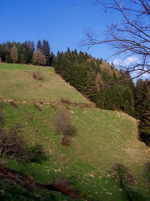
View from south
There are two reasons why I created a page for this summit: because of the the nice flowers on the hill and because there is a peculiar geographical/geological spot at the foot of the hill that I try to describe.
‘Križ’ in the root of the word ‘Križevski’ means ‘Cross’, but more likely it is in connection with a crucifix.
The hill is built of the common gneiss. It doesn’t have sharp shapes. Its summit is rounded and covered with dense spruce forest, so from the very top there is no panoramic view. Nevertheless many of its hillsides are meadows with good views. The hillsides are steep - Križevski vrh is surrounded with deep valleys from east, from south and from west.
Vegetation
Approximately half of the area of the hillsides of Križevski vrh is covered by spruce forests, and the other half is covered with meadows, with some farm houses on them. There are many species of beautiful flowers here, mainly at the borders of forests and meadows. See some examples inserted into this page as illustration.  |  |  |  |  |
Route
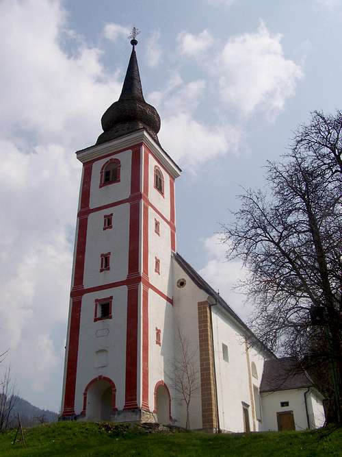
The St Leonard church in Mislinja
The trail
2.5 km, 1 hour. Altitude difference: 385 m
Access to the trailhead:
From Ljubljana: Take the A1 highway to the direction of Maribor. At Žalec you maust leave the highway and drive 23 km to north to Velenje. From Velenje it’s a further 13 km driving and you reach Mislinja. You will see a beautiful church after entering the city. 100 meter after the church take the first street to the right, and then cross the river. A fewhundreds meter further you reach the foot of the mountain.
Route description:
This route goes north-northeast from Mislinja. The route is sometimes only a tourist path, while sometimes it is along local macadam roads. In the first 2 kilometres the route crosses a spruce forest, then some meadows. Don’t be surprised: it crosses also the courts of 3 farmhouses. After 2 km of walk – at the 3rd farmhouse - you reach Križevski vrh (1004 m). The marked path don’t go up to its peak but go around it (west to it), following the macadam road. You can ascend the summit either from south, from the 3rd farmhouse, or from north, from the 4th farmhouse. In both cases first you have to cross a small meadow, and then finding the non-marked path leading to the summit.
From Križevski vrh you can continue your way to Črni vrh:
At the saddle north to Križevski vrh you must leave the road to the right direction and walk 2400 m first on a path, then on a forestry roads, and finally again on a macadam road. You will have to leave the macadam road to the left where the tourist sign indicates it. Soon you will arrive to a junction of tourist paths: the one to the right would take you to Ribniška Koča while the one to the left takes you to Črni vrh. Not much later there will be another junction of tourist paths: the left one would take you to Grmovškov dom (hut) – but you have to take the right one going up to the summit of Črni vrh. Not far from here the dense forest is not so dense eny more and soon you reach the open summit of Črni vrh with the monument on it.
Where is the church St Leonard?
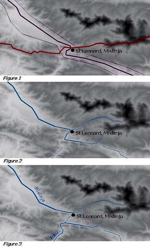
The Lavanttal fault
The church of St Leonard of Mislinja is a beautiful building that was erected in the 17th century. It is a baroque building with some late-renaissance style elements.
This church is in a special position. It is at the point where the watershed of the Drava and Save valleys crosses the Lavanttal/Labot fault. On Figure 1 you can see the mainline and the borders of the Lavanttal/Labot fault with purple lines, while the red line indicated the watershed between the Drava and Save valleys.
And there is another “issue” here. The Pohorje mountain range is a very young formation: it elevated east to the older Lavanttal/Labot fault only in the last 15 million years. It’s likely that the elevation of the Pohorje mass changed the way of some rivers. Now the river Paka having its first kilometres in the Lavanttal/Labot fault turns to south at the village Gornji Dolič, cutting over a mountain with a canyon-like valley (see Figure 3). But it’s likely that more than 7-8 million years ago – when the elevation of the Pohorje mass was not so advanced yet – the same river followed the way of Lavanttal/Labot fault, and instead of turning to south at “Gornji Dolič”, it continued its way further along the fault. Please see Figure 2 for the details (please note that the hills and valleys were not exactly the same 7-8 million years ago – the illustration gives only the logic and not the exact topography). Of course at that time the watershed didn’t cross the fault at the location of the present day St Leonard church, but 6 km south-east to it, near the present-day source of Paka river.
.
.
.
.
.
.
Population of the area
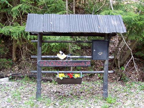
Welcome board of the Mencinger-Stopernik farm
Črni vrh / Schwarzkogel
Mislinja / Missling
Mala Mislinja / Klein Missling
Gornji Dolič / Ober Dollitsch
Šentilj pod Turjakom / Sankt Ilgen
Accomodation
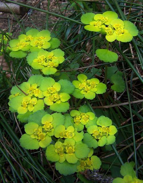
Golden Saxifrage
Camping Center Kekec, Maribor
Campsite Menina, Rečica ob Savinji
Campsite Park, Prebold
Mountain Huts:
Ribniška Koča
On 1507 m. Opened in whole year. Phone: 0602/68246 (from 1996)
Photos: here.
Grmovškov dom
On 1377 m. Phone: 02 8839860 and 031 680547; e-mail: lenka.jeromel@kope.si
Web page in Slovenian here