
-
 3795 Hits
-
 80.49% Score
-
 12 Votes
|
|
Mountain/Rock |
|---|---|
|
|
46.47136°N / 15.31298°E |
|
|
Hiking |
|
|
Spring, Summer, Fall, Winter |
|
|
5030 ft / 1533 m |
|
|
Topographic isolation: 4.5 km
Nearest higher peak: Jezerski vrh, 1537 m
Prominence: 233 m![Large Ringlets (Erebia euryale)]()
Large Ringlets (Erebia euryale)Mulejev vrh is the 4th highest summit of Pohorje.
The name Mulejev vrh means Mulej's Hill in Slovenian language.
Mulejev vrh is in the central part of Pohorje mountain range. Though the nearby Rogla is the best known mountain of the central part of Pohorje, Mulejev vrh is the highest summit here. Its altitude is 1533 m - only 4 meter lower than the nearest higher summit – Jezerski vrh – that can be found already in the western part of pohorje. The saddle between Mulejev vrh and Jezerski vrh is called Preval Šiklarica (with 1300 m altitude).
This summit doesn’t have a shape of a sharp peak. Like the other summits of Pohorje, its shape is more like a dome: deep valleys around the mountain, steep slopes emerging from the valleys, and an almost flat hilltop.
The mountain is built of volcanic-origin rock. It doesn’t absorbs water, so there are many creeks on the mountain. The streams on the east side go directly into Drava. The streams on the west side flow into the small river Mislinja. This small river confluences with Drava 25 km further, at the end of its valley. The precipitation is around 1000 mm/year, though it also depends on the altitude where it is measured.
![View from the outlook tower of Mulejev vrh]()
Mulejev vrh summitMulejev vrh has an almost flat hilltop. It doesn’t provide the usual Alpine peak feeling. Despite Mulejev vrh has a central position within the Pohorje, you can't see good panoramic views. The forest is too dense for the panoramic views. Beside a transmission station there is a minor outlook tower – but it is not higher than the trees around, so finally tourists climbing the tower can look only to western direction among the trees. In clear weather there they can see the beautiful Kamnik-Savinja Alps.
The very summit - where the outlook tower is – can be found only with some efforts. No marked path leads there. West to the summit there is a marked route with southern-northern lead. Where this route reaches its highest point, there you have to leave the path into eastern direction. Hardly visible paths with no signs lead to the highpoint of Mulejev vrh. It is approximatley 150 m far from the marked route. The very summit can be identified with the small transmission station. The summit is mainly covered with forest of spruce trees, but there are also some grassy areas and blueberry fields.![The largest lake of Lovrenška jezera]()
The largest pond![Water / Grass]()
Water / GrassThe real attraction of Mulejev vrh is not the summit itself but the nearby area called Lovrenška Jezera. There are a few peculiarities with this lake:
1) It’s “almost” on the summit of Mulejev vrh. Only in 13 meter lower position. It’s not usual to have a lake almost on the top of hills. This is possible here because of the character of Pohorje: relatively flat summits and flat mountain ridge. And the rock of Jezerski vrh doesn’t absorbs water. The result is a marshy area nearby the summit with several lakes. 19 lakes, but their number can be higher or lower depending on the precipitation os the season.
2) There is Mugo (dwarf) pine here around the lake. Mugo pine is not usual in Pohorje, the only other place where it grows is around the Jezerski lake (please correct me if there are more such places in Pohorje). Mugo pine normally doesn’t grow in the Alps below 1650 m. This is an exception with the altitude of 1520 m.
The lakes are north to the summit of Mulejev vrh, in 1.3 km distance. Well marked tourist paths lead to the lakes.
These 19 lakes that are considered a natural phenomenon. The ombrogenic-biogenic origin of these lakes lies in the post glacial period (about 8000 years ago). Typical vegetation: Mugo (dwarf) pines, turf moss, round-leaved sundew, marsh tea, moss rose and Alpine rust rose (Rhododendron ferrugineum) - protected species. The most interesting water animal that can be found in this region is the Alpine water newt. The wood grouse and blackcock also nest in the vicinity of the lakes.
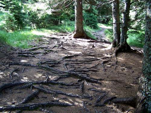
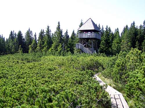
In order to protect the lakes, tourists can access it only on wooden boards. Leaving this artificial path is forbidden. If anybody wants to see such parts of the marshy land that can1t be seen from this path, he can go up to the outlook tower that is constructed here for the tourists.![Tourist path on Mulejev vrh]()
A marked route![The outlook tower at Lovrenska Jezera]()
On marshy land...Recently new signs have been erected along the tourist paths, so orientation is easy for the toursits
From Ribniška Koča mountain hut (1507 m)
6.2 km, 2 hours. Total altitude gain (one way): 270 m
Access to the trailhead:
We drive to Maribor and then keep on driving upwards the Drava valley towards Radlje ob Dravi. We must pay attention when we arrive to village Ožbolt. 5 kilometres after Ožbolt a road towards Ribnica na Pohorju goes left (across a bridge). When we arrive to the center of Ribnica, a signpost for Ribniška koča directs us left upwards. We follow this road which soon becomes a macadam. In winter time the road is driveable only till the ski slope on Ribniško Pohorje. This extends our walk with 20 minutes.
Route description:
We start at the hut and follow the road in eastern direction to a little grassy saddle. Here we leave the road and direct straight (slightly right if we are coming from the hut) on a path over a meadow upwards. The path through the meadow takes us to Jezerski vrh after 10 minutes of walking. The summit is crowned with a huge monument. Leaving the summit in eastern direction, nearby the route there is the famous Jezerski lake where you can have a rest. 1.5 east to the lake you reach the lowpoint of the route: the saddle called Preval Šiklarica (1300 m). 2 km further to east there is a junction of paths: turn here right (into southern direction). Soon you arrive to another junction: take here the right path, too, still keeping the southern direction. In 25 minutes you reach the highpoint of the route – you are on Mulejev vrh.
From Koča na Pesku (mountain hut near Rogla, 1386 m)
3,3 km, 1 hour. Total altitude gain (one way): 200 m
Access to the trailhead:
From Ljubljana: Take the A1 highway to the direction of Maribor. Exit at Slovenske Konjice and then towards Zreče. Follow the road towards Rogla Ski Centre. Don’t park at the ski slope keep on driving till Koča na Pesku mountain hut, and park there. Koča na Pesku is a bit further down the saddle of Rogla.
Route description:
From the mountain hut go 1 km west, slightly downwards along the road. Turn left to a footpath at a point where the road takes a right curve. On the path you will get to a small artificial lake. Only a few dozen meters from the lake you cross a small bridge over a stream. Cross the bridge, and on the other hand a signpost indicates that you are on track. The way forward is an ascend on a footpath for about 20 minutes up to the crossroads. Here take the left path. After 300-400 m you get to another junction of paths: here turn right. In 25 minutes you reach the highpoint of the route – you are on Mulejev vrh.
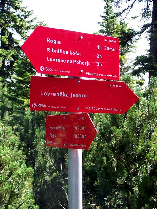
![Information]()
Tourist information
From Hotel Planja (on Rogla, 1474 m)
3.5 km, 1 hour. Total altitude gain (one way): 117 m
Access to the trailhead:
From Ljubljana: Take the A1 highway to the direction of Maribor. Exit at Slovenske Konjice and then towards Zreče. Follow the road towards Rogla Ski Centre. Park your car at the ski slope.
Route description:
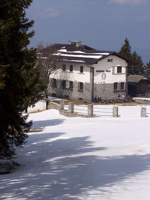
From the parking lots go the the direction of a house where the winter ski season tickets are sold. Cut across the ski route and continued your way on broad medows slightly downwards. At the lowest point you can notice the signpost indicating the way to Lovrenška Lakes. Soon you get the the broad summit of Ostruščice (1498 m). Walking further you arrive to the saddle Komisija (1446 m). There is also a junction of paths. Proceed on the left path, and in 25 minutes you reach the highpoint of the route – you are on Mulejev vrh.![RibniÅ¡ka koÄa mountain hut]()
Ribniška KočaCampings:
Camping Center Kekec, Maribor
Campsite Menina, Rečica ob Savinji
Campsite Park, Prebold
Mountain Huts:
Ribniška Koča
On 1507 m. Opened in whole year. Phone: 0602/68246 (from 1996)
Photos: here.
Koča na Pesku (mountain hut near Rogla)
On 1385 m. Phone: 03 757 71 67
This house on Pesek is situated only 3 km from the Planja hotel, in a pleasant sunny place.
In the house there are 47 beds, suitable for climbers, trekking enthusiasts, school trips. All rooms have multiple beds and bunks, one bathroom per floor with toilets, and a common room. In addition, the Cabin also has a restaurant. The horse-riding centre on Pesek offers field or paddock riding, horse pair or draught dog drives, and fishing on lake Masin zaga in the immediate area of Pesek.
![White Waterlily (Nymphaea alba)]()
White waterlily
Nearest higher peak: Jezerski vrh, 1537 m
Prominence: 233 m
Overview
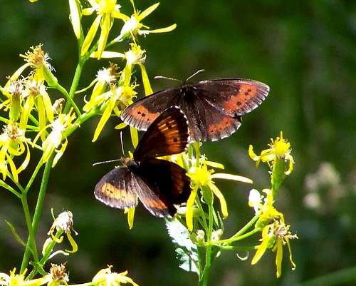
Large Ringlets (Erebia euryale)
The name Mulejev vrh means Mulej's Hill in Slovenian language.
Mulejev vrh is in the central part of Pohorje mountain range. Though the nearby Rogla is the best known mountain of the central part of Pohorje, Mulejev vrh is the highest summit here. Its altitude is 1533 m - only 4 meter lower than the nearest higher summit – Jezerski vrh – that can be found already in the western part of pohorje. The saddle between Mulejev vrh and Jezerski vrh is called Preval Šiklarica (with 1300 m altitude).
This summit doesn’t have a shape of a sharp peak. Like the other summits of Pohorje, its shape is more like a dome: deep valleys around the mountain, steep slopes emerging from the valleys, and an almost flat hilltop.
The mountain is built of volcanic-origin rock. It doesn’t absorbs water, so there are many creeks on the mountain. The streams on the east side go directly into Drava. The streams on the west side flow into the small river Mislinja. This small river confluences with Drava 25 km further, at the end of its valley. The precipitation is around 1000 mm/year, though it also depends on the altitude where it is measured.
On the Summit

Mulejev vrh summit
The very summit - where the outlook tower is – can be found only with some efforts. No marked path leads there. West to the summit there is a marked route with southern-northern lead. Where this route reaches its highest point, there you have to leave the path into eastern direction. Hardly visible paths with no signs lead to the highpoint of Mulejev vrh. It is approximatley 150 m far from the marked route. The very summit can be identified with the small transmission station. The summit is mainly covered with forest of spruce trees, but there are also some grassy areas and blueberry fields.
Lovrenška Jezera – the Lakes

The largest pond

Water / Grass
1) It’s “almost” on the summit of Mulejev vrh. Only in 13 meter lower position. It’s not usual to have a lake almost on the top of hills. This is possible here because of the character of Pohorje: relatively flat summits and flat mountain ridge. And the rock of Jezerski vrh doesn’t absorbs water. The result is a marshy area nearby the summit with several lakes. 19 lakes, but their number can be higher or lower depending on the precipitation os the season.
2) There is Mugo (dwarf) pine here around the lake. Mugo pine is not usual in Pohorje, the only other place where it grows is around the Jezerski lake (please correct me if there are more such places in Pohorje). Mugo pine normally doesn’t grow in the Alps below 1650 m. This is an exception with the altitude of 1520 m.
The lakes are north to the summit of Mulejev vrh, in 1.3 km distance. Well marked tourist paths lead to the lakes.
These 19 lakes that are considered a natural phenomenon. The ombrogenic-biogenic origin of these lakes lies in the post glacial period (about 8000 years ago). Typical vegetation: Mugo (dwarf) pines, turf moss, round-leaved sundew, marsh tea, moss rose and Alpine rust rose (Rhododendron ferrugineum) - protected species. The most interesting water animal that can be found in this region is the Alpine water newt. The wood grouse and blackcock also nest in the vicinity of the lakes.
In order to protect the lakes, tourists can access it only on wooden boards. Leaving this artificial path is forbidden. If anybody wants to see such parts of the marshy land that can1t be seen from this path, he can go up to the outlook tower that is constructed here for the tourists.
Routes
A marked route
On marshy land...
From Ribniška Koča mountain hut (1507 m)
6.2 km, 2 hours. Total altitude gain (one way): 270 m
Access to the trailhead:
We drive to Maribor and then keep on driving upwards the Drava valley towards Radlje ob Dravi. We must pay attention when we arrive to village Ožbolt. 5 kilometres after Ožbolt a road towards Ribnica na Pohorju goes left (across a bridge). When we arrive to the center of Ribnica, a signpost for Ribniška koča directs us left upwards. We follow this road which soon becomes a macadam. In winter time the road is driveable only till the ski slope on Ribniško Pohorje. This extends our walk with 20 minutes.
Route description:
We start at the hut and follow the road in eastern direction to a little grassy saddle. Here we leave the road and direct straight (slightly right if we are coming from the hut) on a path over a meadow upwards. The path through the meadow takes us to Jezerski vrh after 10 minutes of walking. The summit is crowned with a huge monument. Leaving the summit in eastern direction, nearby the route there is the famous Jezerski lake where you can have a rest. 1.5 east to the lake you reach the lowpoint of the route: the saddle called Preval Šiklarica (1300 m). 2 km further to east there is a junction of paths: turn here right (into southern direction). Soon you arrive to another junction: take here the right path, too, still keeping the southern direction. In 25 minutes you reach the highpoint of the route – you are on Mulejev vrh.
From Koča na Pesku (mountain hut near Rogla, 1386 m)
3,3 km, 1 hour. Total altitude gain (one way): 200 m
Access to the trailhead:
From Ljubljana: Take the A1 highway to the direction of Maribor. Exit at Slovenske Konjice and then towards Zreče. Follow the road towards Rogla Ski Centre. Don’t park at the ski slope keep on driving till Koča na Pesku mountain hut, and park there. Koča na Pesku is a bit further down the saddle of Rogla.
Route description:
From the mountain hut go 1 km west, slightly downwards along the road. Turn left to a footpath at a point where the road takes a right curve. On the path you will get to a small artificial lake. Only a few dozen meters from the lake you cross a small bridge over a stream. Cross the bridge, and on the other hand a signpost indicates that you are on track. The way forward is an ascend on a footpath for about 20 minutes up to the crossroads. Here take the left path. After 300-400 m you get to another junction of paths: here turn right. In 25 minutes you reach the highpoint of the route – you are on Mulejev vrh.
Tourist information
From Hotel Planja (on Rogla, 1474 m)
3.5 km, 1 hour. Total altitude gain (one way): 117 m
Access to the trailhead:
From Ljubljana: Take the A1 highway to the direction of Maribor. Exit at Slovenske Konjice and then towards Zreče. Follow the road towards Rogla Ski Centre. Park your car at the ski slope.
Route description:
From the parking lots go the the direction of a house where the winter ski season tickets are sold. Cut across the ski route and continued your way on broad medows slightly downwards. At the lowest point you can notice the signpost indicating the way to Lovrenška Lakes. Soon you get the the broad summit of Ostruščice (1498 m). Walking further you arrive to the saddle Komisija (1446 m). There is also a junction of paths. Proceed on the left path, and in 25 minutes you reach the highpoint of the route – you are on Mulejev vrh.
Accomodation
Ribniška Koča
Camping Center Kekec, Maribor
Campsite Menina, Rečica ob Savinji
Campsite Park, Prebold
Mountain Huts:
Ribniška Koča
On 1507 m. Opened in whole year. Phone: 0602/68246 (from 1996)
Photos: here.
Koča na Pesku (mountain hut near Rogla)
On 1385 m. Phone: 03 757 71 67
This house on Pesek is situated only 3 km from the Planja hotel, in a pleasant sunny place.
In the house there are 47 beds, suitable for climbers, trekking enthusiasts, school trips. All rooms have multiple beds and bunks, one bathroom per floor with toilets, and a common room. In addition, the Cabin also has a restaurant. The horse-riding centre on Pesek offers field or paddock riding, horse pair or draught dog drives, and fishing on lake Masin zaga in the immediate area of Pesek.
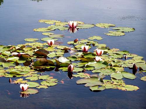
White waterlily
SzaniUherkovich - Jul 31, 2012 5:14 pm - Hasn't voted
Re: Vegetation chapterYou are right. I fixed the issue now. Thanks for the careful reading!
yatsek - Aug 1, 2012 4:36 am - Voted 10/10
Re: Vegetation chapterThanks for providing an interesting thing to read. I'm looking forward to seeing your first page on a Transylvanian mountain. Has the land beyond the forest been forgotten?:)