
|
|
Mountain/Rock |
|---|---|
|
|
48.77300°N / 116.769°W |
|
|
Hiking |
|
|
Spring, Summer, Fall, Winter |
|
|
6727 ft / 2050 m |
|
|
Overview

The lookouts on the summit
The views are great!
Lookout Mountain stands above the north end of Priest Lake, Idaho, directly west of The Lionshead and north of Chimney Rock and Harrison Peak. It sports 2 lookouts on its summit: the original lookout built in 1929, which is on the national historical lookout register, and a newer one built in 1977, which is still used. Although its summit is reached by hiking a trail, this peak, as most of the others in the Selkirks, has an imposing, vertical north face. Neither climbing guide I have mentions any routes on this face, which is odd, as access to this area is one of the shorter, easier ones around.
I mainly added this page because this is a great trip for families. The views are some of the best in the area.
Getting There
Travel to Priest River via Highway 2 that runs between Sandpoint, Idaho, and Newport, Washington. At the light in Priest River, turn north onto state highway 57. After about 22.5 miles turn right onto the Dickensheet – East Shore Road for Coolin (well signed). Continue through Coolin along the east side of Priest Lake until you reach Lionshead Campground, about 19 miles.
Main Approach
WARNING The last 6 miles of road to the trail head are rough, but have been improved. A vehicle with good clearance is recommended and depending on conditions, 4WD would help.

Lookout Lake and the north face of Lookout Mountain
Continue on the East Shore road another 4.5 miles (1/2 mile after milepsot 23) and turn right onto road Id State Forest Rd #44. After 2.4 miles, turn right onto road #43, which turns sharply left and becomes #432 in about ½ mile. Continue on #432 (total 3.2 miles from #44). There will be a gate (open) and a wide area with ample parking. A single piece of ribbon on the east road bank marks the beginning of the trail to Lookout Lake.

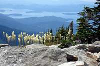
Beargrass along the way
You can continue on the road until it dead ends. The trail coming from Lookout Lake intersects here and continues on up to Lookout Mountain summit. You would eliminate about 45 minutes walking but also miss the nice lake and the very alpine views of the north side of the mountain. This is the way the lookout staff accesses the peak.
Alternate Approach
If your car cannot make it up the usual way, there is another possible route, but it is very long with at least 1000 feet more of elevation to gain.
Before reaching Lionhead Campground, turn east onto Lion Creek Road (State Forest Road #42) just after crossing the Lion Creek Bridge. There are several low angle forks - always take the left one, but ignore any sharp lefts. About 1½ miles before the end of the road and 3 miles from the main road turnoff, the old road to the lookout takes off to the north. It is listed as trail #423. Hike up this road/trail to the summit (or even mountain bike it). Apparently some ride their ATV's up it and it appears to be popular with snowmobilers.
Camping
Lookout Lake offers good and scenic camping spots and there is enough room to camp at the trailheads. Otherwise there are several campgrounds near Priest Lake but reservations may be needed during the main summer season.
Red Tape and Other Considerations
No permits are needed.
This is black bear, moose and cougar country, so be aware and use appropriate camping precautions. I have had no critter problems myself in over 30 years of working and playing in this area and I hope it stays that way!
There are few streams along the trail - the only reliable water is at Lookout Lake.