
-
 5232 Hits
-
 76.47% Score
-
 7 Votes
|
|
Mountain/Rock |
|---|---|
|
|
47.00790°N / 22.91003°E |
|
|
Sălaj |
|
|
Hiking |
|
|
Spring, Summer, Fall, Winter |
|
|
3268 ft / 996 m |
|
|
Topographic isolation: 8 km
Nearest higher peak: Vf. Scoruşeţului (1158 m)
Prominence: approximately 465 m
Overview
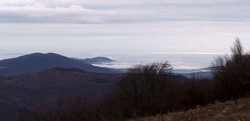
View of Mountain Meses from Magura Priei
Hungarian name: Perjei-Magura, Perje-tető or simply Perje.
Name of the mountain derives from the name of the nearby village called Pria/Perje.
In the following text I give both Romanian and Hungarian versions of the geographical names.
Munții Meseș/Meszes-hegység is a northern mountain group of Munții Apuseni/Erdélyi-középhegység. Munții Meseș/Meszes-hegység is approximately 50 km long. Its highest peak is Măgura Priei/Perjei-Magura. Various sources define its height between 989 and 998 m.
The main ridge of the mountain has southwest–northeast direction. Southwest to the peak there is the saddle called Pasul Plopiş/Plopis-hágó, with altitude of 646 m. Road nr. 108G goes over this pass, connecting Vânători/Börvény with Vârșolț/Varsolc. There is another mountain range west to the pass: Munții Plopiș/Réz-hegység. The next peak 5 km northeast to Măgura Priei/Perjei-Magura is Citera Ponița (858 m).
Măgura Priei/Perjei-Magura is a relatively important watershed. Waters of the eastern slope of the montain feed Someș/Szamos. Waters of the southwest slope of feed Criș/Körös. Waters of the northern slope feed Crasna/Kraszna. These streams are Cizer/Csizér, Valea Boului, Pria/Perje and Ponița. These 4 small streams are considered as the sources of the 193 km long river Crasna/Kraszna.
The mountain is built of Schist.
Flora and Fauna
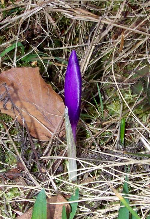
Spring is here! Crocus vernus
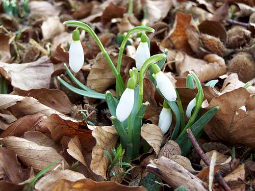
Snowdrops on the summit
See here the some listed species of the local flora and fauna:
Flora
European beech (Fagus sylvatica), Sessile oak (Quercus petraea), European hornbeam (Carpinus betulus), Turkey oak (Quercus cerris), European ash (Fraxinus excelsior), Field elm (Ulmus foliaceae), English oak (Quercus robur), Scots pine (Pinus sylvestris), Silver birch (Betula pendula), European crab apple (Malus sylvestris), European wild pear (Pyrus pyraster), European alder (Alnus glutinosa), Crack willow (Salix fragilis), Red elderberry (Sambucus racemosa), Black elderberry (Sambucus nigra), Common hazel (Corylus avellana), Wild privet (Ligustrum vulgare), Common dogwood (Cornus sanguinea), European cornel (Cornus mas), European bladdernut (Staphylea pinnata), Mezereon (Daphne mezereum), Common hawthorn (Crataegus monogyna), Blackthorn (Prunus spinosa), Blackberry (Rubus fruticosus), Dog rose (Rosa canina), European blueberry (Vaccinium myrtillus), Raspberry (Rubus idaeus), Wood spurge (Euphorbia amygdaloides), Spiny restharrow (Ononis spinosa), Broadleaf plantain (Plantago major), Campanula serrata (Campanula serrata), Lungwort (Pulmonaria officinalis), Woodruff (Galium odoratum), Sanicle (Sanicula europaea), Wood anemone (Anemone nemorosa), Wild strawberry (Fragaria vesca), Isopyrum thalictroides (Isopyrum thalictroides), Corydalis solida (Corydalis solida), Alpine cyclamen (Cyclamen purpurascens), Greater celandine (Chelidonium majus), Motherwort (Leonurus cardiaca), Common comfrey (Symphytum officinale), Shepherd’s purse (Capsella bursa-pastoris), Common centaury (Centaurium umbellatum), Alpine squill (Scilla bifolia), Wood sorrel (Oxalis acetosella), Glechoma hirsuta (Glechoma hirsuta), Ramsons (Allium ursinum), Autumn crocus (Colchicum autumnale), Crocus banaticus (Crocus banaticus) – endemic specie in Romania, Crocus vernus (Crocus heuffelianus), Yellow bedstraw (Galium verum), Oxeye daisy (Leucanthemum vulgare), St John’s wort (Hypericum perforatum), Snowdrop (Galanthus nivalis), Spring snowflake (Leucojum vernum), Yellow sweet clover (Melilotus officinalis), Red clover (Trifolium pratense), Coltsfoot (Tussilago farfara), Flat sea holly (Eryngium planum), Field horsetail (Equisetum arvense), Common cowslip (Primula veris), Yarrow (Achillea millefolium), Great yellow gentian (Gentiana lutea) – protected specie, Peppermint (Mentha piperita), Common dandelion (Taraxacum officinale), Common heather (Calluna vulgaris), Lesser pond sedge (Carex acutiformis), Kentucky bluegrass (Poa pratensis), Rough bluegrass (Poa trivalis), Roadside fescue (Festuca drymeja), Field wood-rush (Luzula campestris), Greater wood-rush (Luzula sylvatica)
Mushrooms
Penny bun (Boletus edulis), Boletus aereus (Boletus aereus), Horse mushroom (Agaricus arvensis), Green-cracking russula (Russula virescens), Saffron milk-cap (Lactarius deliciosus), Peppery milk-cap (Lactarius piperatus), Clustered coral (Ramaria botrytis), Chanterelle (Cantharellus cibarius), Parasol mushroom (Macrolepiota procera)
Mammals
Gray wolf (Canis lupus), Wild boar (Sus scrofa), Red fox (Vulpes vulpes crucigera), Roe deer (Capreolus capreolus), European badger (Meles meles), Eastern gray squirrel (Sciurus carolinensis), European polecat (Mustela putorius), European hare (Lepus europaeus)
Birds
Eurasian jay (Garrulus glandarius), Golden oriole (Oriolus oriolus), Common pheasant (Phasianus colchicus), Great spotted woodpecker (Dendrocopus major), Black woodpecker (Drycopus martius), Nightingale (Luscinia megarhynchos), Common blackbird (Turdus merula), Rook (Corvus frugilegus), Tree swallow (Tachycineta bicolor),House sparrow (Passer domesticus), Common cuckoo (Cuculus canorus), Common chaffinch (Fringilla coelebs), Eurasian sparrowhawk (Accipiter nisus)
Reptiles and amphibians
Sand lizard (Lacerta agilis agilis), European green wizard (Lacerta viridis viridis), Slow worm (Anguis fragilis), Common frog (Rana temporaria), European fire-bellied toad (Bombina bombina), Yellow-bellied toad (Bombina variegata), Europen green toad (Bufo viridis), Fire salamander (Salamandra salamandra)
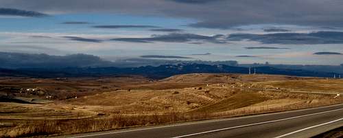
Highpoint of County Szilágy
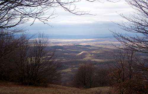
View of Szilágy County
County Szilágy is a young county: it was established as part of the administrative reform of the Hungarian Kingdom in 1876. In 1920 its area has been attached to Romania. Between 1940-1944 it belonged again to Hungary, and from 1944 (de jure from 1947) it is again part of Romania.
The county has mixed population. The villages at the foot of the mountain (Pria/Perje, Hurez/Bagolyfalu, Huta/Csákyújfalu, Vânători/Börvény) have Romanian population, while north to the mountain there are several villages with Hungarian population (like Crasna/Kraszna and Vârșolț/Varsolc).
State Borders and Wars
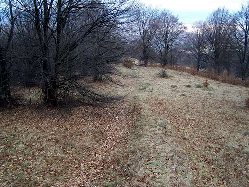
WWII trench - 12th October 1944?
Roman Empire
Dacia was annexed to the Roman empire in 107 a.d. and it existed as a Roman province until 274 a.d. Limes Porolissensis was a defensive line on the northwest border of the province, organized in the 2nd century AD after the conquest of Dacia, having observations towers, short cut-off walls and fortifications. Still there are visible and restored parts of the defensive walls. Archeologists found the traces of this vallum on the ridge of Munții Meseș/Meszes-hegység, from Poieni/Kissebes to Tihău/Tihó. 10 km east to the peak of Măgura Priei/Perjei-Magura a restored Roman fort can be visited in village Buciumi/Vármező.
WWII
From 1940 the state border between Hungary and Romania was only 15 km south from Măgura Priei/Perjei-Magura. In the Second World War in October 1944 the unified Sowiet and Romanian forces attacked this border. On the 11th October the Hungarian army withdrew its forces from the border into Mountain Meseș/Meszes. But they could keep their positions here only for a week. At Pass Plopiş/Plopis there is a small memorial written in Romanian language, reminding people about the recapture of the area by the Romanian forces in 1944.
I suspect that the trench that can be seen on my photo is from this time.
Architectural Heritage
Visitors of Măgura Priei/Perjei-Magura can admire some beautiful old wooden churches here:• Fildu de Sus/Felsőfüld – church built in 1727
• Tusa/Tuszatelke – church built in the 18th century
• Sârbi/Krasznatótfalu – church built in 1760
How to Get There
Route E60
• Cluj/Kolozsvár: 83 km distance. Take route E60 to Ciucea/Csucsa. Here turn right to the direction of Vârșolț/Varsolc. Stop at Pass Plopiş/Plopis after 10 km driving
• Budapest: 355 km distance. Take route E60 to Ciucea/Csucsa. Here turn left to the direction of Vârșolț/Varsolc. Stop at Pass Plopiş/Plopis after 10 km driving.
Route
Easiest approach from Pass Plopiş/Plopis. From here walk 1.5 km in eastern direction on the dirt road. There you can decide to take a shortcut on the steep hillside (no trail) in the direction of the peak, or to follow a longer forest road. From here it’s another 2-2.5 km to get to the peak.Camping
Bungalows Refugiu Osteana (505 m) near Vânători/Börvényt.Website: http://www.infopensiuni.ro/cazare-ciucea/pensiuni-ciucea/pensiunea-refugiul-osteana1
Camping Eldorado (320 m) near Gilău/Gyalu. Unfortunately this camping is in more than 40 km distance from our mountain.
Website: http://www.eurocampings.co.uk/en/europe/romania/campsite-eldorado-117108/
Maps
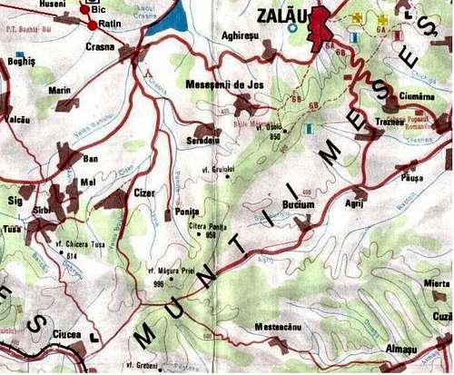
Map of Magura Priei
Link to a recent map: http://www.profudegeogra.eu/wp-includes/imagine_marita.php?locLinkB=http://www.profudegeogra.eu/wp-content/uploads/2011/06/apuseni.jpg