
-
 10799 Hits
-
 89.01% Score
-
 28 Votes
|
|
Mountain/Rock |
|---|---|
|
|
48.51500°N / 120.6568°W |
|
|
7040 ft / 2146 m |
|
|
Overview
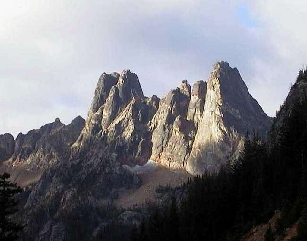
| The Liberty Bell group dominates the North Cascades Highway (SR 20) at Washington pass. The view of it from the tourist overlook (drive the short spur from a quarter-mile W of the pass) is so spectacular that having climbed the peak, you'll be compelled to drag your girlfriend, your mom, the hitchhiker you just picked up – anybody – to the overlook to say, “Yeah, I climbed it. No sweat. It's a mile and a half above sea level, you know.” She gazes in awe at the 1,000-foot E face that holds such routes as Liberty Crack and Thin Red Line, and you neglect to mention that you climbed up the other side, via the 3-pitch 5.6 Beckey route. [No, I'm not denigrating the Beckey route. One of my favorites in the Cascades, I've done it about a dozen times and would love to do it a dozen more. As for those Big Wall routes on the E face, I'm entirely unworthy.]
In this photo from cluck [Thanks!], Liberty Bell is on the right. Concord Tower is immediately left of it, mostly hidden. Halfway up the side of Concord is little Minuteman. Contrasting nicely in the morning sun, it's nearly invisible in the afternoon. Climbing Minuteman is about as fine a way to spend a day as you could want. It involves about a half-dozen pitches of Class 5 rock, some on excellent granite, at least one stretch on dangerously rotten crap. No sneaking around back to a gully here; the route is entirely on the visible sunlit face, with one exception: Where the face goes dead vertical 2/3 of the way up, the route takes a chimney right in the shadow line facing us. Beckey's guidebook calls the standard route a Grade III, 5.8 A1. It goes free at 5.9. The exposure is impressive for such a little guy. Pity it won't get you laid. |
 |  |  |  |  |
Getting There
Drive SR 20 to a few hundred yards E of Washington Pass. There's a little pond next to the road at about 5,400 feet; park near it and unload your stuff. Skirt the left side of the pond and head up through the forest, bearing SSW until you break out into the talus field (about 6,000 feet) under this face of Liberty Bell and Minuteman. Ascend and cross the talus to the left corner of Minuteman's base, 6,600 feet. If the talus is snow-covered, boulder the first few feet of the base to a dry ledge to change into rock shoes.
[Elevations and direction above are based on my memory and the 7.5-minute quad, which neglects to show the highway, the pond, or the peak. If you go there and find out I'm wrong, let us know, and I'll fix it.]
 |
Red Tape
Parking along the highway in Okanogan National Forest requires a Northwest Forest Pass ($5/day or $30/year) It's good in all the National Forest day-use areas in Washington and Oregon, and can be purchased at most ranger stations, or online right here.
When To Climb
Mid-May or June through mid-October. The gullies between the peaks of the Liberty Bell Group are so tight they can hold tremendous loads of snow, in spite of their steepness. Fred Beckey recommends descending across the gully to the N onto the lower apron of Liberty Bell. I'd rather not venture across that on a hot Spring afternoon when tons of snow and rock are melting loose above.
The North Cascades Highway is normally closed by the snow from mid-November to mid-April or May, with the single exception of 1976-77, the driest winter here since the road was completed. If you insist on a winter attempt, come up from the East.
Camping
I can't remember a flat space between SR 20 and the base of Minuteman, and it may not be legal to camp there. Climbers often bivy at the Blue Lake trailhead, ½ mile W of Washington Pass, especially since that's the starting point for all the W side approaches in the group. The closest official campgrounds are Early Winters and Klipchuck, both to the East. I'm partial to Klipchuck: it's far enough off the highway to be quiet, and it has sinks and flush toilets. It often has open sites when other campgrounds are full. There's a possibility of encountering rattlesnakes there – watch your step on trails, and consider snakes if you're contemplating just spreading your bags on the ground for the night.
Mountain Conditions
The Cascade Range separates the soggy marine climate of the Puget Sound basin from the semi-arid realm of the Columbia Plateau. Driving E across the northern part, the range is so broad you'll see the transition to drier forest begin miles before you reach the crest. The Liberty Bell Group, including Minuteman, is much drier than the mountains you'll pass on the drive from the West, a major factor in its popularity.
That doesn't mean you can leave your jacket at home. On various climbs in this group I've been hit by rain, thunderstorms, snow, and hail, all in Summer. Or you may be parched. Carry water. For weather reports, refer to the National Weather Service. They're running an experimental “point forecast” obtained by clicking your location on a map. It's a little hard to tell, but Minuteman looks to be about here. If they stop the point forecast system, use the City, State box at the top of the left sidebar on most Weather Service pages to enter Mazama, WA.
Check with the state Highway Department to avoid rude surprises. Sometimes rock avalanches or the danger of them have closed the road even in dry weather.
Books and Maps
Fred Beckey's Cascade Alpine Guide Vol 3: Rainy Pass to Fraser River is our most comprehensive source of climbing info for the region. Volume 3 (350 pages) covers just the N portion of the North Cascades. Still, Minuteman rates less than ¼ page in my 1981 edition.
My 1993 edition of Nelson and Potterfield's Selected Climbs in the Cascades does not feature Minuteman, but one of the photos of the E face of Lexington, Concord, and Liberty Bell shows Minuteman well enough to pick out the route.
Jeff Smoot's Rock Climbing Washington includes the E face of Minuteman, devoting about one more sentence to the description than Beckey's guide. Smoot rates the route Grade III, 5.10b. Whether some radical change has occurred in the last 20 years, or Smoot rates routes harder than I thought i could climb, or we were off route, I don't know. See the “I Could be Wrong...” section at the bottom of the East Face route page. Then climb the route and bring back details and photos for the rest of us.
The 1968 volumes of both the American Alpine Journal and the Mountaineers annual include Scott Davis and Bill Lingley's first ascent accounts of Minuteman, according to a note in Beckey's guide.
The USGS 7.5-minute quad Washington Pass gives you about as much detail as you can expect in a map, but Minuteman is so small, it shows as a barely-discernible ledge on Concord. Being one of Washington State's earlier 7.5-minute maps, it was printed before the existence of the North Cascades Highway; it shows only a trail passing to the north.
Acme Mapper gives full-page satellite photos and maps, including USGS topos. On this page, the summit is marked A, the pond where I parked is B. Much more parking space is available at the hairpin marked C.