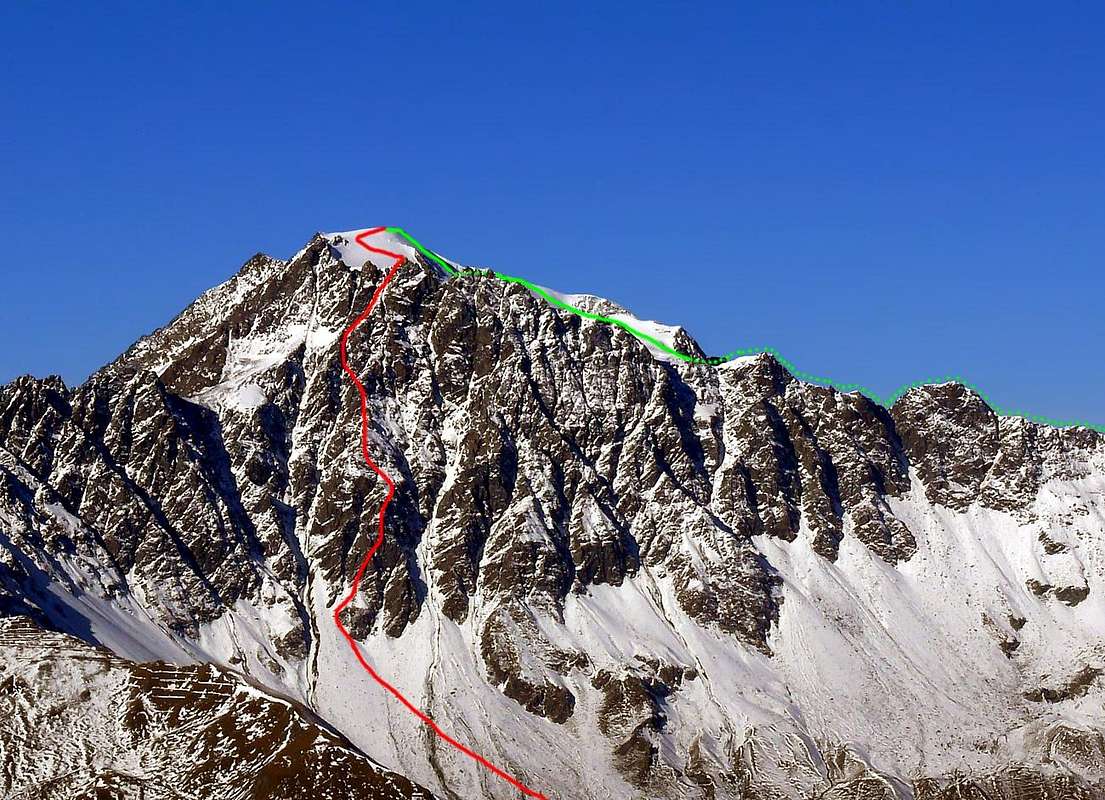
Appropriate Routes
MONT VELAN (3734 m) S-SE FACE from right or East by halfcircular ascent progressively to the left or West:
Starting, along the route from
Valsorey 's Pass (Normal Via; 3107m), from
Testa d'Ariondet also
Tête de Riondet (Ariondet Head)
(3485m), Ariondet 's "Carving" (3480 metres about),
Velan's Little Tooth (about 3530/35 meters),
Velan's five Dents ( or
Jags;
the major or highest and more Western 3595 metres),
Jags's Saddle (3557 metres about), Velan's three
Horns with the
(Eastern 3618 metres about, Mini Central 3615 around and barely noticeable, Western 3620m ), Horns Eastern Brèche
(3610/12 metres about), Horns Western Triple Brèches
(3605 metres about, 3608 metres about, 3628/30 metres about), Quota 3650 metres, Quota 3672 metres, Quota 3708 metres (towards Molline/Menouve Vallons) to the rounded
Ice Cup or true Mont Velan or Mont V'lan Summit
(Ice Cup; 3734m). To the left or Northwest:
Quota 3678 metres (towards Molline/Menouve Vallons) with the West Crest descending above the
Hannibal's Pass (2992m), just at the end of the same valley and between the Italian/Swiss border.
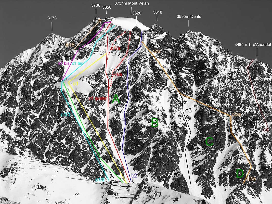
VELAN South PILLARS or Southern rocky RIBS, with the relative COULOIRS and GULLIES:
VELAN all Southern PILLARS on the East-southeast Face above the Conca ((Basin) de By
A = Velan 's Western Horn South Pillar or
"Hourglass Pillar" ;
B = Velan 's Eastern Horn South Pillar ;
0 = Velan 's Five Teeth to more
Western also I°
Dent or
Jag with the
Southern Pillar also
"Streched Pillar" (not marked, located between c3 and C);
00 = "Hanging Pillar" (unmarked in photo, situed always between c3 and C in picture, but in high more to the East and to II° and III° Teeth);
C = Southern Central Pillar towards the
V° Tooth ;
D = Velan 's Jags towards the
VI° Tooth or V'lan 's Little Tooth also more
Eastern Pillar, baptized by me as
"Broken Double Angular Southern Pillar", as soon as previous the wide East-southeast faces of
sixth Dent or Little Jag (just detached East-southeast; about 3530/35 metres) and the
Tête de Riondet also
Testa d'Ariondet (3485m)
.
![]() Quota 3678 metres, two Horns, two mini Horns & five Jags South-southeast Walls,
Quota 3678 metres, two Horns, two mini Horns & five Jags South-southeast Walls,
Picture by Antonio, traced by Osw
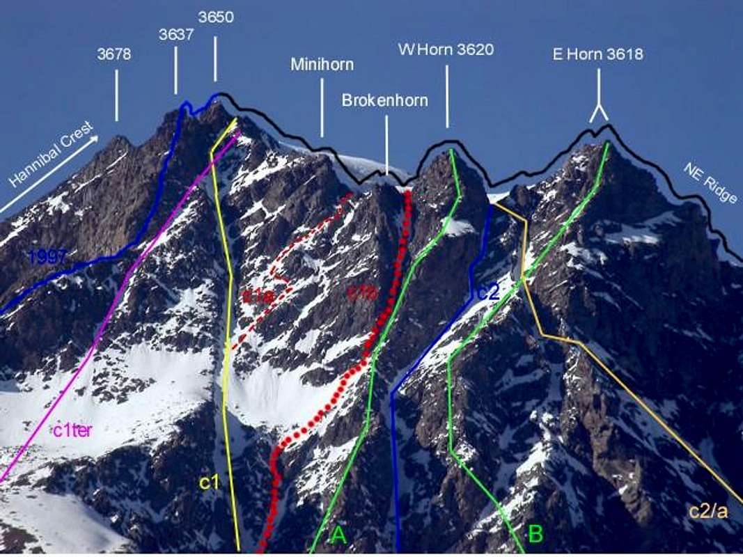
AOSTA VALLEY in SUMMITS MOUNT VELAN EKITS OUT to HORNS Mont Velan's HORNS EXITS OUT toward the HORNS ROUTES about 850/900 metres high From left (West):
*Just starting from the Hannibal 's Western Crest of the Quota 3678 meters: towards the
Ice Cup Mount Velan also the true
Top; on August 31th, 1779
(first absolute ascent); Summer 1826 (entirely in descent, after the third ascent absolute).
S-SW Ridge July 27th, 1997, in descent from
Quota 3650 meters. C1ter
Diagonal Route to West Triple Brèche July 15th, 1976, in ascent (3628/30m~).
(lemon yellow color) Western Great CouloirC1)- August 16th, 1890, in descent; June 14th, 1904 in ascent (partially), from
Faceballa Saddle. December 28th, 1904 (idem in First winter absolute of mountain and integral in descent).
** Routes from (in descent) also towards the (in ascent) Quota 3650 meters; even from or to West Triple Brèche (3628/30m~). Minihorn Central Triple Brèche (3608m~):
c1a)-, with the second part of descent through the
Southern Great Couloir C1, July 18th, 1997, in descent from East Triple Brèche
(3605m~) between
Minihorn and
Brokenhorn (with bifid top) into the
Great Couloir or
C1quater Via; c1b)- July 18th, 1997, in ascent and in day towards the rocky carving between the doubelr and smaller
Brokenhorn and
Western Horn, after the first part through the
Southern Great Couloir C1.
West Horn 3620 metres;
A)- July 25th, 1997, in ascent by
"Hourglass Pillar" always in day.
West Horn Western Brèche
(3610/2m~);
c2)- July 25th, 1997, in descent by
"Narrow Gully/Couloir".
Eastern Horn (3618 meters~);
B)- September 27th, 1998, in ascent by
Southern Pillar with integral descent in day by
(lemon yellow color) C1 into the great
Southern Couloir, as from the route of August 16th, 1890 by Ellis Carr, William Martin Conway, F.M. Davies with the swiss guides Ulrich Kaufmann and Joseph Marie Lochmatter.
West Horn Western Brèche
(3610/2m~) from base with progressive traverse to the left or West on
Central Pillar, Central great Couloir and,
(ocher yellow color),
c2/a)- June 28th, 1920. Climb combined with the following crossing always to the left or West briefly with traverse, before in almost horizontal route and after in diagonal to the Northwest, on
South Pillar of more
East Horn and below the next smaller
Central Horn reaching a carving just under and in right (East) of the most
Western Horn.
IMPORTANT NOTE: Complicated and complex way, also rather dangerous because it is very exposed to falling stones, that in practice begins at the base of
(see photo above) D = Velan 's Jags towards the VI ° Tooth or more
Eastern Pillar also
"Angular Broken Double Southern Pillar", as soon as previous the wide East-southeast face of
sixth Dent or Little Jag (just detached East-southeast; about 3530/35 meters). Therefore there are no other routes on the rocky Teeth between the great double gully of
c3; also the new route into the snowy and icy couloir towards the
Teeht 's "Carving" or
Jags's Saddle (3557 metres about). Ascent by Osvaldo Cardellina, on August 27th, 1995, lone, in day and through descent along the
Southern Great Couloir, route of August 1890 and labelled with
(lemon yellow color) C1) and the
"Halved Couloir", just preceding the traversal route
c2a of June 1920. Even the large sector of the gully between
c3 (of C = Southern Central Pillar towards the V ° Tooth; always see the picture above) ) and
c2a is quite dangerous due to the identical reasons and there is no type of ascension below the five plus one teeth. Farther East, under the
Testa d'Ariondet with
c4 route; there is the via of 25 July 1916 of Mario and Nunzia Borelli. It is also known of an attempt
(by a climber engaged on the difficult, wide and triangular wall of the Testa d'Ariondet) in the first decade of the 2000 with a mountaineer recovered however by helicopter.
*** East-northeast Ridge from Valsorey Pass (3107m): Monks of Gr. St. Bernard D'Allèves and Marquis on Summer 1826 (in occasion of third absolute of mountain ascent) with route in the highest final part.
East-northeast Ridge or Standard Via with variant integral from and towards the Valsorey Pass (3107m): August 17th, 1975, Osvaldo Cardellina, Marco Cossard, Camillo Roberto Ferronato, Giuseppe Lamazzi and Roberto Meneghini in ascent and in descent (with during the descent by Osvaldo Cardellina, lone, the second absolute ascent of Doigt du Velan
(Velan 's Finger);
3314m) and in day from the Pastures of By 's Conca; first entire and integral. Repeated by Osvaldo Cardellina, "Gigi" Gadin and Faustin Savoye, July 15th, 1976 second complete and integral, in descent, after the "Diagonal Gully" in ascent.
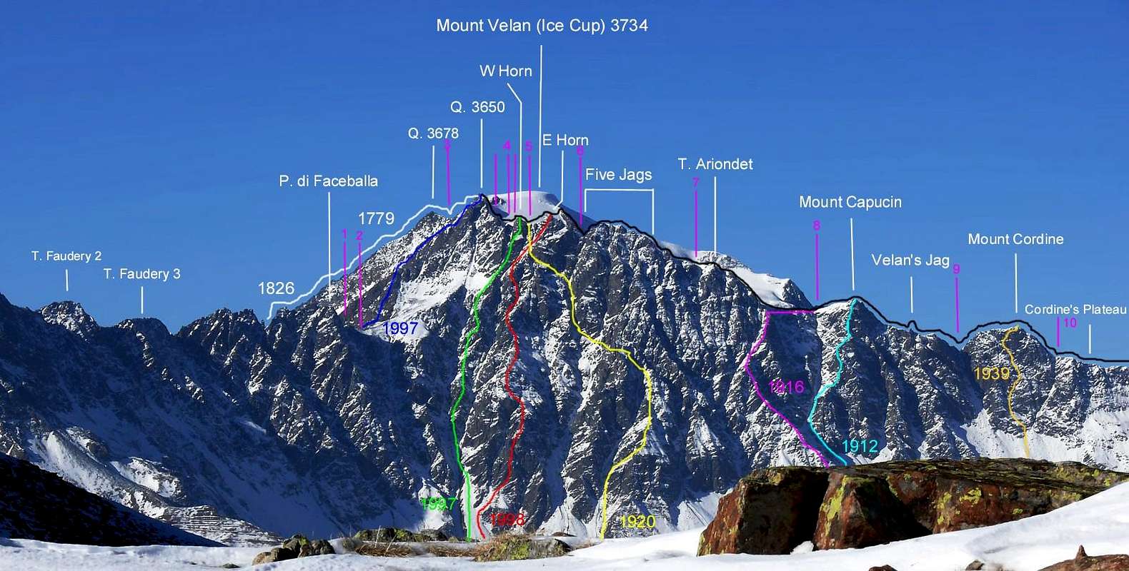
![]() Main Routes from Faceballa Saddle to the Valsorey Pass on South-southeast and East-southeast Faces ,
Main Routes from Faceballa Saddle to the Valsorey Pass on South-southeast and East-southeast Faces ,
Picture by Antonio, traced by Osw
MONT VELAN (3734m) S-SE and E-SE FACES of ALL SUMMITS ON the ROCKS * From left (West) ALL Rocky ROUTES:
* 1799, Aug. 31th: Westerner Ridge or Hannibal's Crest: Abbot Gr. St. Bernard and Naturalist Laurent-Joseph Murith and the Hunter Genoud in superior third of crest
(in left by B14)- ), after initial ascent on
W-NW Slope of crest in
FIRST ABSOLUTE ASCENT of MONT VELAN. 1826, on Summer; Abbots D'Allèves and Marquis in descent integral to
Hannibal Pass.
1997 Routes: , Jul. 27th, 1997
Souhwestern Ridge (amongst
1872/b15)- and of
1973/c1bis)- routes; Osvaldo Cardellina, lone, in descent and in day from Mont Velan 's
Quota 3650 metres to
Faceballa Pass. 1997, July 25th:
South-southeastern Face, by
Western Horn South Pillar also
"Hourglass Pillar"; Osvaldo Cardellina, lone and descent in day with integral, by
Western "Narrow Couloir" (c2)- ).
1998 Routes: Sep. 27th, 1998:
S-SE Face, by
Eastern Horn 's Southern Pillar; Osvaldo Cardellina, lone and descent integral in day, by
Western Great Couloir (c1quater)- ).
(lemon yellow color)
1920 Route: Jun. 28th, 1920:
S-SE Wall, by
Velan's Jags or Teet South Central Pillar c2/a;
partial in inferior part, crossing to the left or West towards Central Great Couloir (c3)- and
Eastern Horn South Pillar) to more
Eastern Horns Brèche; Antonio Frisoni, Cesare Negri, Luigi Vavassori and Carlo Virando.
1916 Route: Jul. 25th, 1916: of
Ariondet Head , by
c4 via and traverse to
Ariondet "Carving" on
E-NE Great Crest or
c5)- that is Italian Normal Route; Mario Borelli and Nunzia Borelli.
1912 Route: Oct. 17th, 1912:
Mont Capucin Southeast Face, between
c5)- , c6)- routes
(dated but not marked in pictures); Abbot Joseph Maria Henry and Mountain Guide Théodhule Forclaz.
1939 Route: Aug. 17th, 1939:
Mount Cordine SE Face, between
c6)- , c6bis)- routes
(dated but not labelled in pictures); Giovanni Soncelli and Paride Tagliabue.
** In high against the sky and on Italian/Swiss border, in year 1826, on Summer:
East-northeast Crest lomg ascent by the two Abbots of the Great Saint Bernard Pass D'Allèves and Marquis, in superior part from the more
Western Velan's Horns (3620m) towards the
Ice Cup Summit. 1976, Jul. 15th:
East-northeast Ridge Osvaldo Cardellina, Luigi Gadin and Faustin Savoye, in day and in integral descent from Ice Cup Summit to Valsorey Pass and, in the same day,
Velan's Finger or Jag second absolute ascent, by Osvaldo Cardellina, lone, after the first by the Abbot Joseph Maria Henry in August 11th, 1922.
*** In purple color, the various
Cols or Passes, Saddles, Brèches and snowy "Carvings" or rock "Notches": 1)- Faceballa Pass (3239m);
2)- Faceballa Saddle (3280m);
3)- Quota 3650 meters; 4)- Western Triple Brèche (3628/30, 3608, 3605 metres about);
5)- Eastern Brèche (3610/2 metres about);
6)- Jags's Notch (3557 metres about);
7)- Ariondet "Carving" (3480 metres about);
8)- Capucin Pass (3376m);
9)- Southwestern Chamois Pass (3259m);
10)- Southeastern Chamois Pass (3420 metres about) and just before the
"Plateau de Cordine" (about 3221 meters), preceding the
Col de Valsorey (3107m).
![]() "Modern Via on S-SE Face 1998" & Normal "September 1891" for descent towards Valsorey Pass,
"Modern Via on S-SE Face 1998" & Normal "September 1891" for descent towards Valsorey Pass,
Picture & traced by Antonio
![]() This is the homologous or Southwestern Face: various Western heights, Velan and to the right or East the V'lan's Horns, Teeth on South-southeast Walls,
This is the homologous or Southwestern Face: various Western heights, Velan and to the right or East the V'lan's Horns, Teeth on South-southeast Walls,
Picture by Antonio, traced by Osw
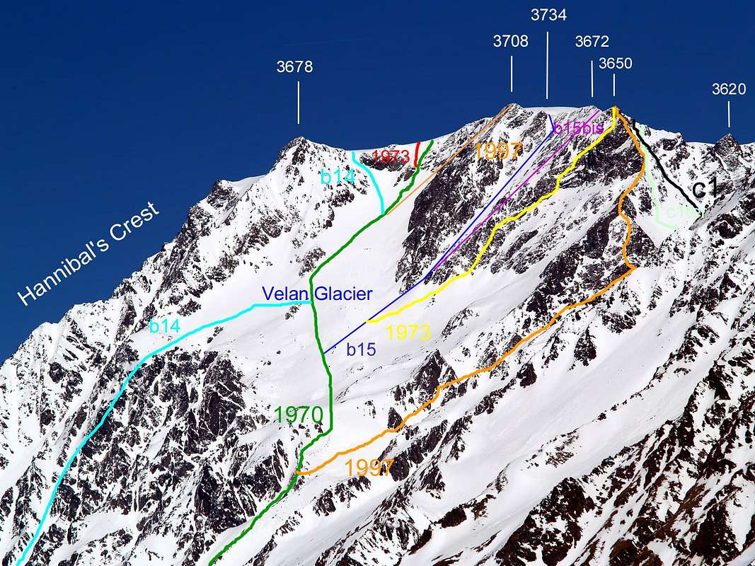
* The other and opposite to the West face of MONT VELAN or V'LAN (3734m) S-SW FACE (Molline/Menouve) Frontally from left:
Western Crest or Hannibal's Ridge at the end of double and deep
Menouve/Molline Valley and from the homonym Pass Aug. 31th, 1779, ( Laurent-Joseph Murith and Génoud), in ascent, by West Slope and in superior part from
Quota 3400 metres around; in descent and in integral 1826 (the two abbots of the Gran San Bernardo Col scilicet the swiss D'Allèves and Marquis).
** S-SW SLOPE (Menouve and the superior Molline Vallons):
starting from low or from the current Molline's Bivouac
(2415m; since 2005) into the superior Molline Vallon, towards the
Saddle about 3640 meters, in ascent
b14)- . Sep. 04th, 1901, (Guido Cibrario, Franco Viale and swiss Mountain Guides Daniel Balley and Omer Balley);
Southwest Face "Superdirect route" in ascent and crossing of all summit small dômes
(3678, 3670, 3734, 3708, 3672 metres), in day from Prailles small Hamlet (1500 metres about). Sep. 06th, 1973, (Osvaldo Cardellina and Renzo Botti);
SW Face "Direct Route", in descent. Oct. 31th, 1970 (Gino Buscaini and Silvia Metzeltin Buscaini);
NW Wall of Quota 3708 meters, in ascent and in day from Quaye Alp (1600 metres about). Jul. 27th, 1997 and in day (Osvaldo Cardellina, lone);
Western Wall of Quota 3708 meters, variant on a small pillar of the more Western Face of
Quota 3708 meters with ascent in day from
Quaye Alp (1600m~). Always by initial approach with the same routes of
ITALIAN SKI-MOUNTAINEERING ROUTE. Aug 31th, 1999 and in day (Osvaldo Cardellina, solo)
W-SW "Inclined Couloir" of the
Quota 3708 meters, at the
Double Northern Saddle 3650 meters about , in descent
b15)- . Sep. 03th, 1872 (H.J. Leaf, Walter Leaf ) with swiss Mountain Guide Hans Baumann and Valtournanche Mountain Guide Daniele Bich;
West Face of Quota 3672 metres towards the
Double South Saddle 3647/50 metres around, in ascent
b15bis)- . Jul. 15th, 1902 (Agostino Ferrari, Edoardo Garrone with Valtournanche Mountain Guide Cesare Meynet);
SW Wall of Quota 3650 meters, in descent. Sep. 06th, 1973 and in day, (Osvaldo Cardellina and Renzo Botti);
S-SW Ridge of Quota 3650 metres to the
Faceballa Saddle 3280 metres, in descent. Jul. 27th, 1997, in day (Osvaldo Cardellina, lone).
*** S-SE FACE (Comba Berruard/By Basin):
side on right (East): from Faceballa Saddle
3280 metres towards the
S-SE WALL, above Berruard Comba/By Conca or Basin, in right (East):
Little Saddle 3450 metres about, S-SW Ridge and S-SE Wall, in ascent (
c1bis)- ,
unmarked and no traced in photo). Oct. 31th, 1970 (Gino Buscaini and Silvia Metzeltin Buscaini);
S-SE diagonal Gully and S-SE Great Couloir, in ascent c1ter)- . Jul. 15th, 1976, in day (Osvaldo Cardellina, "Gigi" Gadin and Faustin Savoye)
S-SE Face, Western Great Couloir, in descent
c1)- . Aug. 16th, 1890 (Ellis Carr, William Martin Conway, F.M. Devies) with swiss Mountain Guides Hulrich Kaufmann and Joseph Marie Lochmatter.
In ascent, by
Faceballa Saddle with
C1, Jun. 14th, 1904 (Abbots Pantaléon Bovet and Maria Joseph Henry ). In winter and in ascent with
C1quater (see above the first photo) and in day from Champillon Alp!
(2050m), by
Faceballa Saddle, Dec. 28th, 1904 (Abbot Pantaléon Bovet, Evanzio Blanc and Maria Joseph Henry and Jaccod).In descent, by integral
S-SE Western Great icy Channel (C1) towards Doues
(1251 m).
Actually 2019
A very hot summer has upset not only the men but also the mountains that, having lost their glue or "PERMAFROST", have become disjointed and, trembling, unglued. Also the Mont Velan or V'lan was not less and, while its ice melted uninterrupted, even its walls began to quiver more than usual. Self-destructing themselves with continuous falls of stones, if not even small and large landslides. Especially on the South-southeast wall, which I climbed and descended on repeated occasions and on which I already risked being beheaded by a squared losa (tile) in July 1976: it passed, flying like as the Persian flying carpet by Ali Babà , half a meter above my head for then crashing itself with a dull thud just above the Sella (saddle) di Faceballa; all while we were climbing the left or west diagonal canal with Gigi Gadin and Faustin Savoye. A beautiful real scare. This just in mid-July, but three years earlier, to be precise, on 6 September 1973, descending from the Southwestern Wall with the very young Renzo Botti, having reached at almost 40 meters from the basal stone, we were invested in a small rocky canal by a large landslide, which almost destroyed us. A feline leap saved him, while I providentially took cover under a small roof. From an eighty-meter one small pillar had collapsed over our heads and, fortunately, looking up, I had not seen the blue cobalt sky of the day, but a gray cloud. In an instant I understood what was happening and shouting to him the danger we saved ourselves. Terrified, we saw the stones crashing lower, emitting sparks, while a stink of burned sulfur continued to rise from below and towards us for a good quarter of an hour ...
The walls of the V'lan have always been dangerous, especially the South-southeast face facing the city of Aosta and therefore well in sight. But also with regard to the homologous and opposite face Southwest which descends towards the Vallone di Molline / Menouve above the Municipality of Etroubles (1270m) on the road to the Gran San Bernardo. In this year, however, things have deteriorated somewhat due to the scorching heat that burned scree, stones, gravel, rocks and ice; because the same, but especially the Southern one, are completely inadvisable. Unless you try to meet unpleasant or almost unforeseen circumstances. Fortunately, you meet few people around here. At least as far as the highest parts are concerned, well beyond the limits of the pastures. Indeed, as far as I know, none at all ... Therefore, and finally, these walls are more dangerous than not difficult and such as to require a great deal of attention and appropriate choice of situations and conditions. Factors that are often not enough ...
S-SE Face from Conca dell'Acqua Bianca with before and after the vertiginous landslide
Un'estate molto calda ha sconvolto non solo gli uomini ma anche le montagne che, perduto il loro collante o "PERMAFROST", si sono disunite e, tremando, scollate. Anche il Mont Velan o V'lan non é stato da meno e, mentre i suoi ghiacci scioglievano ininterrottamente, pure le sue pareti hanno incominciato a fremere più del solito. Autodistruggendo se stesse con cadute continue di pietre, se non addirittura piccole e grandi frane. Soprattutto sulla Parete Sud-sudest, che ho salito e disceso in ripetute occasioni e sulla quale già nel luglio del 1976 ho rischiato di essere decapitato da una losa squadrata: mi é passata, volando come il persiano tappeto volante di Ali Babà, a mezzo metro sopra la testa per poi schiantare se stessa con un sordo tonfo appena sopra la Sella di Faceballa; il tutto mentre salivamo con Gigi Gadin e Faustin Savoye il canale diagonale di sinistra od Ovest. Un vero e proprio bel spavento. Questo giusto a metà di luglio, ma tre anni prima, per l'esattezza il 6 di settembre 1973, scendendo dalla Parete Sudoccidentale con il giovanissimo Renzo Botti, giunti a quasi 40 metri dalla pietraia basale, fummo investiti in un canalino roccioso da una grande frana, che per poco non ci annientò. Un balzo felino salvò lui, mentre io mi riparai provvidenzialmente al di sotto di un piccolo tetto, per vera fortuna giusto a lato sulla mia sinistra. Un pilastrino roccioso di un ottantina di metri era crollato sopra le nostre teste frantumandosi in mille pezzi e, per improvviso intuito alzando lo sguardo, non avevo più visto il cielo color blù cobalto dell'intera giornata d'ascensione; bensì una grigia nube. In un attimo compresi ciò che stava accadendo ed urlando a lui il pericolo ci salvammo. Atterriti vedemmo le pietre schiantarsi più in basso emettendo scintille, mentre una puzza di zolfo bruciato continuò a salire dal basso e verso di noi per un buon quarto d'ora ...
Le pareti del V'lan sono sempre state pericolose, soprattutto la faccia Sud-sudest rivolta verso la Città di Aosta e quindi bene in vista. Ma anche per quanto concerne l'omologa ed opposta faccia Sudovest che scende verso il Vallone di Molline/Menouve al di sopra del Comune di Etroubles (1270 m) verso il Colle del Gran San Bernardo. In questo anno però le cose sono alquanto peggiorate a causa del caldo torrido che ha bruciato sassi, ghiaie, pietraie, rocce e ghiacci; per la qualcosa le medesime, ma soprattutto quella Meridionale, sono del tutto sconsigliabili. A meno che non si cerchi di andare incontro a spiacevoli imprevisti o quasi. Per fortuna incontri poca gente da queste parti. Almeno per quanto riguarda le parti maggiormente elevate, ben oltre il limite dei pascoli. Anzi, per quel che ne sò, proprio nessuno ...
Quindi, e per concludere, sono queste pareti più pericolose che non difficili e tali da richiedere molta attenzione e scelta opportuna di situazioni e condizioni. Fattori che, spesso, non bastano ...