
-
 5052 Hits
-
 78.27% Score
-
 9 Votes
|
|
Mountain/Rock |
|---|---|
|
|
27.86364°N / 15.61904°W |
|
|
Hiking |
|
|
Spring, Summer, Fall, Winter |
|
|
3474 ft / 1059 m |
|
|
Overview
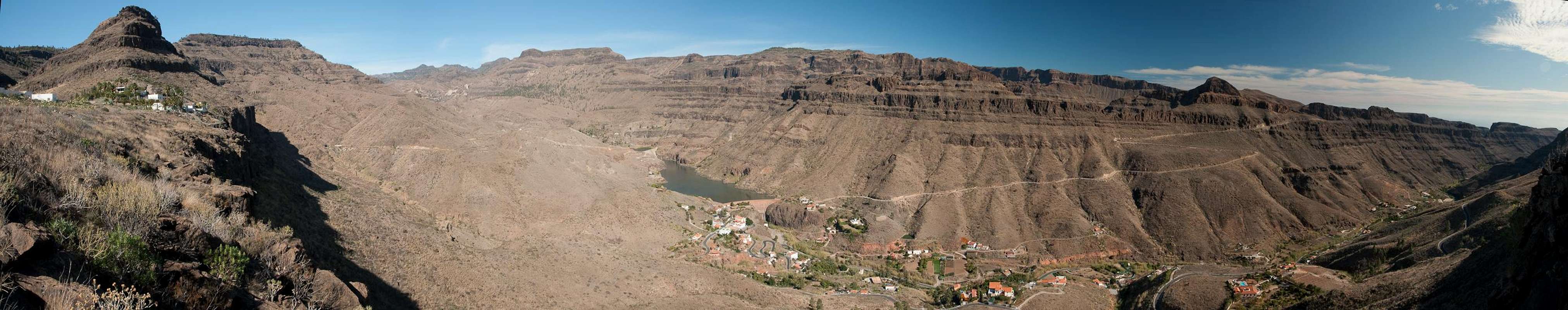
 Montaña Alta above Embalse de Ayagaures Montaña Alta above Embalse de Ayagaures |
Gran Canariais an island with very different aspects. While the main settlements can be found on the east and south coasts, all the way from the island capital Las Palmas de Gran Canaria to Maspalomas in the south, the central part hosts mainly small hamlets and villages. Apart from tourism on the beaches along the coast this disparity ic caused by the regular weather patterns, in which trade wind clouds bring humidity to the north-east of the island while the mountain ranges in the centre stop the clouds and leave the remainder of the island arid and desert-like.
 |  |  |
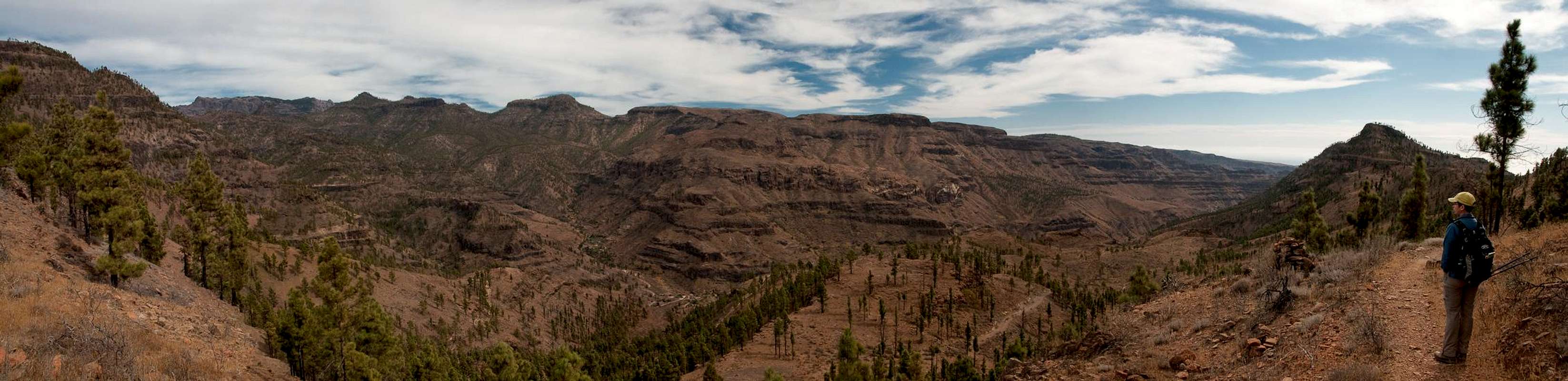
Still, there are large forests of Canary Pines, especially in the south of the island, a huge part of which has been set aside as Pilancones Natural Park. The park was created to protect the pine forests, yet at more or less regular intervals it gets devastated by big fires. They feed on the fallen needles of Canary Pines but rarely hurt the trees themselves, thanks to their thick bark. However, over time most of the pines have fallen victim to the fires and nwoadays the park looks reddish brown wherever you look. Geographically the park is formed by a set of deep barrancos, which are bounded by ridges, which run up to 1500m from the lowest part of the barrancos.
 |  |  |
On the western boandary of the park, one of these ridges culminates in three summits, Montaña de Pino de Eugenio, Montaña Alta and Morro de las Hierbas de Huerto. Despite their longnames the mountains themselves are rather low set flat topped Mesas, which, however, drop with impressive walls into the barrancos below. A long hiking route between Cruz Grande in the centre of the island to Los Palmitos in the south connects the mountains, without actually climbing to their tops. Reaching the summits requires a bit of pathless scrambling in all of the cases. The hiking route is considered to be one of the attractions of the island.
 |  |  |
Montaña Alta is made up from a basalt backbone, which has been covered by volcanic debris over the millenia. on its western side, some of the basalt has been uncovered by erosion and now shows very colorful pillars. The mountain itself is covered with a sparse pine forest which leaves enough room for views across Pilancones Park and the barrancos within. Gran Canaria's Cumbre Central can be seen across the northen boundary of the park, which hides the big walls around Ayacarta.
Getting There
  |
Gran Canaria can be reached from any major European airport. Usually charter carriers fly there but the spanish airline Iberia has also regular flights. The airport is on the eastern coast of the island, far away from the tourist centres in the south.
Most reasonable trailhead for Montaña Blanca is on GC 503 near Ayagaures, a village in the south. Much longer and complicated is the hike from Cruz Grande
- Ayagaures
- Take motorway GC1 to Maspalomas.
- From the exit Maspalomas / Fataga take GC500 / Avenida Alejandro del Castilo through residential areas to the west.
- From the roundabout at the end take GC503 or GC504 to Ayagaures. The trailhead is on GC503 above the village.
- Cruz Grande
- Take motorway GC1 to Maspalomas.
- From the exit Maspalomas / Fataga take GC60 through Fataga and San Bartolome de Tirajana to the road crossing Cruz Grande
Routes
 Morro de la Hierba de Huerto, Montaña Alta, Montaña del Pino de Eugenio
From Ayagaures:
From the trailhead on GC503 head for the mouth of Barranco de los Palmitos, a small canyon, which leads to a mesa-like ridge between the much larger Barranco de Ayagaures in the east and Barranco de Chamoriscan in the west. On the ridge you'll find a path which heads for Montaña Alta but which bypasses it to the west. Head for the summit through the sparsely populated pine forest to its south-west.
From Cruz Grande:
Follow the ridge route towards Morro de la Hierba Huerto. Before you reach it, at Degollada del Sordo turn southward, passing the Morro to its east. A very long ledge traverse leads you to Degollada de los Helechos, from where a broad path takes you down to Los Palmitos. It passes Montaña Alta to its west but there is a path, leading across the north ridge towards the summit of the mountain.
Red Tape
 |
Pilancones is a natural park. The usual restictions apply. Be extremely careful with fire. The black bark of the Canary Pines will tell you why.
Accommodation
Gran Canaria has a lot of options for accommodation. Most visitors book hotel rooms from their travel offices or over the internet. However, you will most certainly end up in the ugly tourist centres along the south coast. Therefore a much better solution is to rent a holiday home, most often a rural finca. This can also be done by travel office or internet.Camping is a bit of an issue on all the Canary Island. There are designated camping zones but getting a place often involves some bureaucracy. The closest campground is at Embalse de las Cuevas de las Niñas some 4km to the east of Cruz Grande. Quite a long way from Montaña Alta, actually.
Camping
The following table gives a rough general overview over the weather on Gran Canaria, at sea level.| Month | Jan | Feb | Mar | Apr | May | Jun | Jul | Aug | Sep | Oct | Nov | Dec |
| Avg. day temp.[°C / °F] | 21 / 70 | 21 / 70 | 22 / 72 | 22 / 72 | 22 / 72 | 23 / 73 | 24 / 75 | 25 / 77 | 25 / 77 | 25 / 77 | 24 / 75 | 22 / 72 |
| Avg. night temp.[°C / °F] | 16 / 61 | 16 / 61 | 16 / 61 | 17 / 63 | 16 / 61 | 17 / 63 | 18 / 64 | 20 / 68 | 20 / 68 | 18 / 64 | 18 / 64 | 17 / 63 |
| Water temp.[°C / °F] | 19 / 66 | 18 / 64 | 19 / 66 | 19 / 66 | 19 / 66 | 20 / 68 | 22 / 72 | 23 / 73 | 23 / 73 | 23 / 73 | 21 / 70 | 20 / 68 |
| Rainy days | 4 | 3 | 2 | 2 | 1 | 1 | 1 | 1 | 1 | 3 | 3 | 3 |
The Canary Islands (as well as Madeira) are located in the trade wind zone. You almost always encounter northeastern winds which carry a lot of humid air. Being forced to climb to higher altitudes this moisture condenses into clouds. This in return means that most of the time the northeastern part of the islands is covered in clouds from altitudes of 1000m through 1500m.
The mountainous region in the centre of the island is of the same alltitude and higher and thus stops the clouds. While the northern parts of the islands can be foggy and rainy the southern parts most often are sunny and hot. On Gran Canaria the north-eastern part of the island collects almost all moisture. However, unlike on the other Canary Islands no cloud forest remains. The laurisilva fell victim to the agricultural development of the island.
Maps & Books
Regular Maps
- Gran Canaria
Kompass Map WK237
Kompass Verlag
1:50000
ISBN 3-85491-114-9
- Gran Canaria North
Public Press Map 442
1:50000
ISBN: 978-3-89920-442-1
- Gran Canaria South
Public Press Map 443
1:50000
ISBN: 978-3-89920-443-8
Digital Maps
Kompass is the only company known to me which offers GPS digital Maps. In addition for those of you with Garmin GPS receivers there is a map source map set of all Canary islands out there.
- Gran Canaria
Kompass GPS4237
Kompass Verlag
ISBN 978-3-85491-219-4
- Inselkartes
OSM Topo Map of European Islands
Garmin Maps
Books
My recommendation is a guidebook by Rother Verlag, available in English and German. The book is an excellent hiking guide covering all the interesting areas of the island. Since it comes with small maps for each excursion it might even be used without a map to support them.
- Gran Canaria
Izabella Gawin
Rother Verlag
ISBN 978-3-7633-4816-9 (English)
ISBN 978-3-7633-4000-2 (German)