
-
 3712 Hits
-
 75.81% Score
-
 6 Votes
|
|
Mountain/Rock |
|---|---|
|
|
27.95358°N / 15.63861°W |
|
|
Hiking |
|
|
Spring, Summer, Fall, Winter |
|
|
4833 ft / 1473 m |
|
|
Overview
 Montaña de los Jarones in front of Morro Pajonales and Montaña de Sandara Montaña de los Jarones in front of Morro Pajonales and Montaña de Sandara |
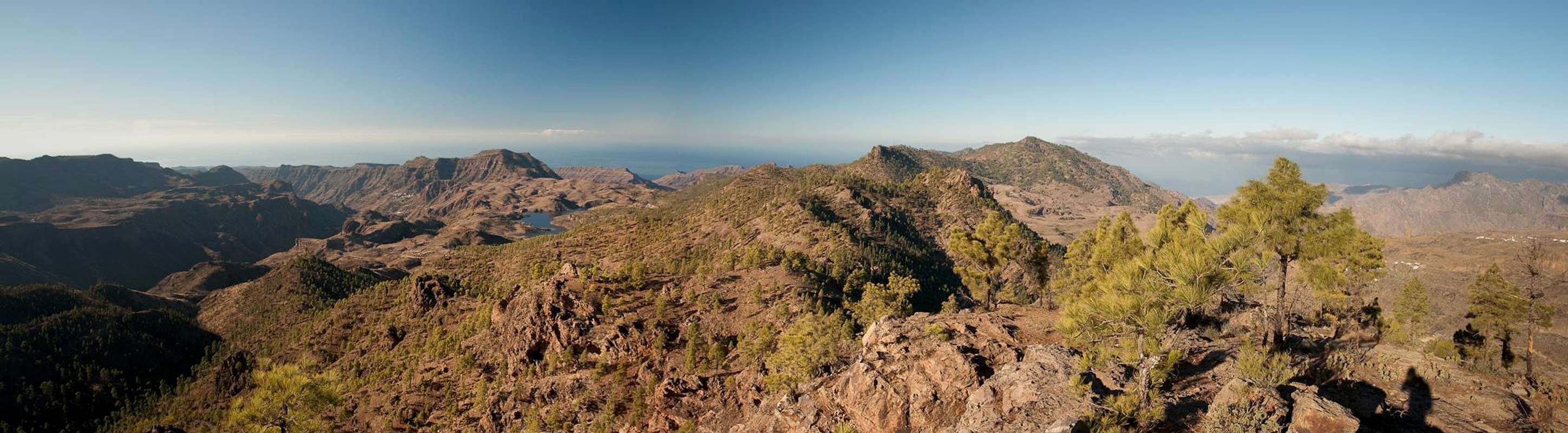
Gran Canaria's largest geographical feature is the giant Caldera de Tejeda, a crater, formed when the islands original stratovolcano collapsed. Millenia of erosion washed the soft volcanic debris away through what is now Barranco de La Aldea de San Nicolas, leaving the giant cauldron. Its northern and eastern sides form the weather divide of Gran Canaria, leaving the interior and the south and east sides desert dry. In the south-east of the crater you find the island's highpoint, Pico de la Nieve, from where the two crater ridges gradually drop towards the sea at San Nicolas in the west. The southern of these branches runs almost directly westward across the northern part of the Cumbre Central as well as the long bend of the Pajonales Crest. it is here, where Montaña de los Jarones is located.
The Pajonales Ridge is a long series of Morros, pine covered hills with rocky basalt tops, often offering good backcountry climbing when the big walls of the Cumbre Central are overcrowded. The area has been set aside as a natural preserve, to protect the fragile Canary Pine forest as well as its inhabitant, the endemic blue Gran Canaria pigeon. Park rules (mainly to stay on trails and don't stay overnight) will be rigidly enforced, mainly to avoid forest fires like the big 2007 one, which devastated huge areas in the south of the island, including Pajonales.
 |  |  |
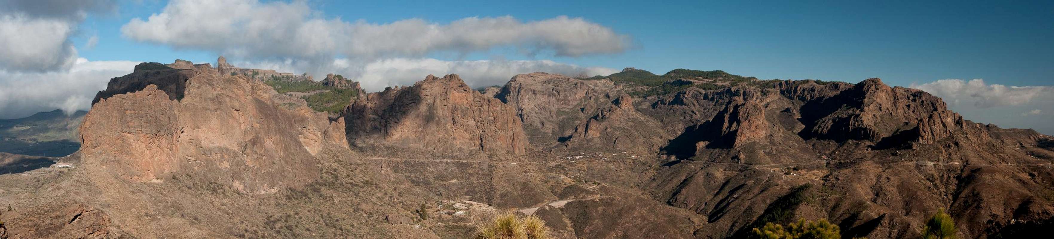
While the road saddle Degollada del Asserador appears like a logical separation between Cumbre Central and Pajonales Ridge the actual separating saddle is Degollada Chimirique. Between the two saddles you find the twin peaked basalt formation Los Canadores, one of the main climbing spots on Gran Canaria. Montaña de los Jarones is the first mountain beyond Degollada Chimirique and thus offers (among) the best views onto the Cumbre big walls and the cut of Ayacata Valley between the two Cumbre branches.
 |  |  |
Montaña de los Jarones is a typical mountain for the Pajonales Ridge. Formed like a hill, rather than a mountain, only its topmost rocky part stands out from the canary pine forest below. The mountain has two summits, which are separated by a small saddle and across both of which the scenic Pajonales Ridge Path leads. To the south, a massive but brittle face drops down to the central plateau of the island. Access to Montaña de los Jarones is rather short: starting to the north of Degollada del Asserador you barely take an hour to reach the summit. The roundaboutish tours from El Juncal and Embalse de las cuevas de las Niñas, however, take half a day and cover more than 500m of elevation gain.
Panoramic View
  |
Getting There
 Montaña de los Jarones
Gran Canaria can be reached from any major European airport. Usually charter carriers fly there but the spanish airline Iberia has also regular flights. The airport is on the eastern coast of the island, far away from the tourist centres in the south.
Trailheads for Montaña de los Jarones are at Degollada del Asserador and El Juncal. You can also start at Presa de las Cuevas de las Niñas though this route is a bit roundaboutish.
- From the south
- From Maspalomas take GC60 through Fataga and San Bartolome to the saddle Cruz Grande.
- From the saddle stay on GC60 until you get to Ayacata.
- For Embalse de las Cuevas de las Niñas turn left onto GC605 which passes the reservoir.
- For Degollada del Asserador and El Juncal stay on GC60. The road to El Juncal turns off left about 500m after the degollada.
- From the north
- From Telde take GC131 which turns into GC130, direction Pico de la Nieve. The road will hit GC150 right at Gran Canaria's highpoint.
- Stay on GC150 for a few metres, then turn onto GC600 to Ayacata.
- For Embalse de las Cuevas de las Niñas turn left onto GC605 which passes the reservoir.
- For Degollada del Asserador and El Juncal stay on GC60. The road to El Juncal turns off left about 500m after the degollada.
Red Tape
Montaña de los Jarones is part of the Reserva Natural de Pajonales. Rules require you to stay on the trails even though some of the most interesting mountains, like Morro de Pajonales are a bit off route. Reason for those restrictions are forest fires, which infrequently but rather regularly devastate this part of the island.Accommodation
Gran Canaria has a lot of options for accommodation. Most visitors book hotel rooms from their travel offices or over the internet. However, you will most certainly end up in the ugly tourist centres along the south coast. Therefore a much better solution is to rent a holiday home, most often a rural finca. This can also be done by travel office or internet.Camping is a bit of an issue on all the Canary Island. There are designated camping zones but getting a place often involves some bureaucracy. The closest campground is at Embalse de las Cuevas de las Niñas some 4km to the north-east of the mountain. Wild camping is not permitted anywhere on the island.
Weather Conditions
 |
The following table gives a rough general overview over the weather on Gran Canaria, at sea level.
| Month | Jan | Feb | Mar | Apr | May | Jun | Jul | Aug | Sep | Oct | Nov | Dec |
| Avg. day temp.[°C / °F] | 21 / 70 | 21 / 70 | 22 / 72 | 22 / 72 | 22 / 72 | 23 / 73 | 24 / 75 | 25 / 77 | 25 / 77 | 25 / 77 | 24 / 75 | 22 / 72 |
| Avg. night temp.[°C / °F] | 16 / 61 | 16 / 61 | 16 / 61 | 17 / 63 | 16 / 61 | 17 / 63 | 18 / 64 | 20 / 68 | 20 / 68 | 18 / 64 | 18 / 64 | 17 / 63 |
| Water temp.[°C / °F] | 19 / 66 | 18 / 64 | 19 / 66 | 19 / 66 | 19 / 66 | 20 / 68 | 22 / 72 | 23 / 73 | 23 / 73 | 23 / 73 | 21 / 70 | 20 / 68 |
| Rainy days | 4 | 3 | 2 | 2 | 1 | 1 | 1 | 1 | 1 | 3 | 3 | 3 |
The Canarian Islands (as well as Madeira) are located in the trade wind zone. You almost always encounter northeastern winds which carry a lot of humid air. Being forced to climb to higher altitudes this moisture condenses into clouds. This in return means that most of the time the northeastern part of the islands is covered in clouds from altitudes of 1000m through 1500m.
The mountainous region in the centre of the island is of the same alltitude and higher and thus stops the clouds. While the northern parts of the islands can be foggy and rainy the southern parts most often are sunny and hot. On Gran Canaria the north-eastern part of the island collects almost all moisture. However, unlike on the other Canary Islands no cloud forest remains. The laurisilva fell victim to the agricultural development of the island.
Maps & Books
Regular Maps
- Gran Canaria
Kompass Map WK237
Kompass Verlag
1:50000
ISBN 3-85491-114-9
- Gran Canaria North
Public Press Map 442
1:50000
ISBN: 978-3-89920-442-1
- Gran Canaria South
Public Press Map 443
1:50000
ISBN: 978-3-89920-443-8
Digital Maps
Kompass is the only company known to me which offers GPS digital Maps. In addition for those of you with Garmin GPS receivers there is a map source map set of all Canary islands out there.
- Gran Canaria
Kompass GPS4237
Kompass Verlag
ISBN 978-3-85491-219-4
- Islas Canarias
Map Source custom map
By Manfred Pepper
downloadable zip-file
Books
My recommendation is a guidebook by Rother Verlag, available in English and German. The book is an excellent hiking guide covering all the interesting areas of the island. Since it comes with small maps for each excursion it might even be used without a map to support them.
- Gran Canaria
Izabella Gawin
Rother Verlag
ISBN 978-3-7633-4816-9 (English)
ISBN 978-3-7633-4000-2 (German)