
-
 8226 Hits
-
 77.48% Score
-
 8 Votes
|
|
Mountain/Rock |
|---|---|
|
|
28.69563°N / 13.92466°W |
|
|
Hiking |
|
|
Spring, Summer, Fall, Winter |
|
|
787 ft / 240 m |
|
|
Overview
 Montaña Colorada and Calderon Hondo Montaña Colorada and Calderon Hondo |
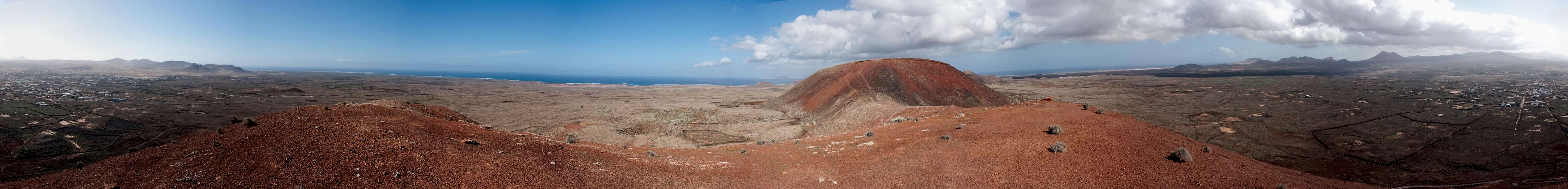
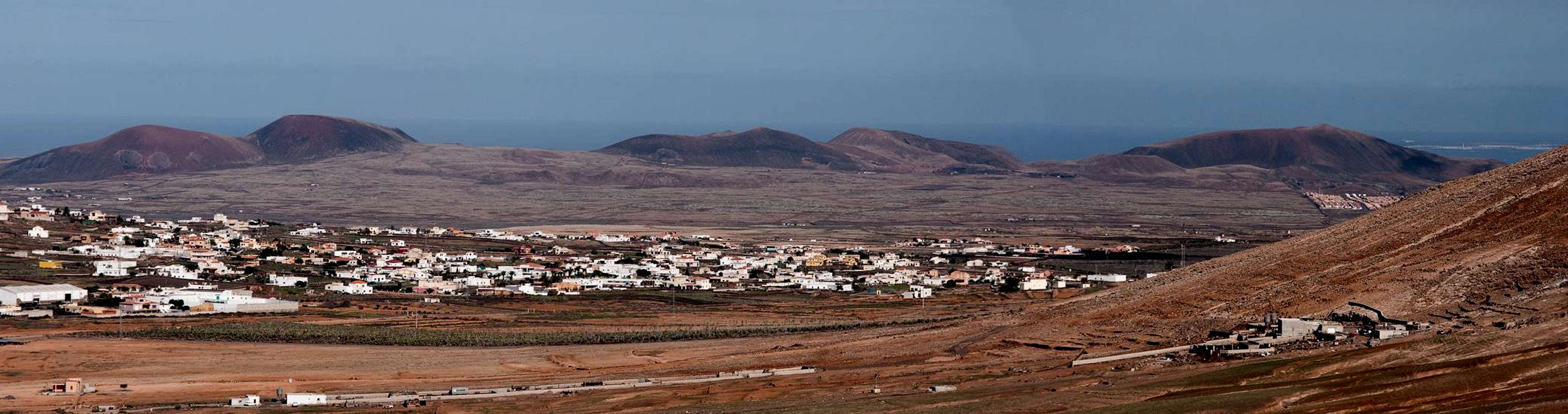
Montaña Colorada, the name says it all. The red mountain is one of the volcanoes, which were created during eruptions about 10000 years ago, which mark the last volcanic activity on the island of Fuerteventura among the Canary Islands. These eruptions extended the island by about 100 square kilometres to the north and formed a large plain of badlands: the Malpais de Bayuyo (named after the northernmost of the volcanoes. During the eruptions six craters were formed, which all lie on a single volcanic rift, which stretches from Corralejo in the north-east to Lajares in the south-west. The south-westernmost of the volcanoes is Montaña Colorada.
Brightly red, the mountain almost fell victim to its colour: on its western slopes the locals of Lajares started to dig for red Lapilli, the lava gravel which is popular on the canaries as it sucks up and keeps humidity and thus is very valuable for local farmers. The red variation is often used in parks to make the "flower beds" more attractive. Here on Montaña Colorada it turned out, however, that the colourful lava forms only a cover of a few centimetres while the bulk of the volcano is formed by the usual black lapilli.
 |  |  |
Today, Montaña Colorada is the westernmost outpost of a regional park, which encompasses the Malpais de Bayuyo with the six craters which created it. Together with the slightly higher Calderon Hondo it forms a twin volcano. The Calderon, a circularly shaped crater, is connected to Montaña Colorada by its west shoulder, on which the lava is most brightly red. There are no official routes onto the summit but tracks show that it can be reached from four sides. The best route, also the least destructive one, follows a dirt road which passes the volcano towards its north. The road ends in the old crater of Montaña Colorada from where a path leads towards the saddle which separates Calderon Hondo from Montaña Colorada. The same spot can be reached from the southern side (very steep) or from the summit of the Calderon (which officially is out of bounds). A fourth route climbs the wet ridge directly.
 |  |  |
Though everything but high, Montaña Colorada still offers good views across the plains of the north of Fuerteventura. Most impressive is the view towards a second chain of volcanoes along the east coast, which culminates in the perfect cone of Montaña de Escanfraga. To the west a third but less important chain can be found and with a bit of luck and clear weather you will be able to see the southern tip of neighbouring Lanzarote across the shoulder of Calderon Hondo.
360° Summit Panorama
  |
Getting There
 |
Though there are ferries from the Spanish mainland to the Canary Islands, they take more than 24h for the trip. Therefore almost all visitors go by plane. Every travel agency in Europe offers flights, hotel rooms, apartments, rental cars etc. so that reaching the Canaries is rather a matter of money than opportunity. During the summer season flight fares can be reasonable but during the Easter and Christmas holidays you have to be prepared for additional fees of 500€ per person.
Fuerteventura has its own airport south of the capital Puerto del Rosario close to the center of the island. There are public bus lines but – like on all the islands – they don't run too regularly. If you plan to stay on your own, better take a rental car right at the airport.
The shortest ascent to Montaña Colorada starts at Lajares, a village to the north-west of La Oliva, administrative seat in the north of Fuerteventura. It can be reached as follows:
- From the airport near Puerto del Rosario take FV-2 north (direction Corralejo)
- Use FV-3, the ring road around the capital Puerto del Rosario.
- North of the capital the ring road joins FV-1 to Corralejo.
- At Casas de las Llanadas switch to FV-102 to La Oliva.
- In La Oliva switch to FV-10 to Lajares.
- Park at the local sports field (you'll have to hike out along a side road to Montaña Colorada, where the Camino Real starts.
Red Tape
 Raven posing on a lava rock in the Malpais de Bayuyo
Strictly speaking, I'm not sure whether this mountain may be climbed at all. tracks indicate that it sees visits and we met one person on the summit. However, the volcano belongs to the Malpais de Bayuyo, one of Fuerteventura's youngest and largest lava fields which may be explored by the paved cobblestone paths only. The lava is brittle and easily breaks apart when you step on it, resulting in a severe danger of injuries. Moreover, orientation in the lava fields can be difficult.
As for the tuff formations (hoodoos) all around the volcano, please stay clear of them. They are erosion structures which easily dissolve at a mere touch. In order not to destroy too much, use the north-eastern ascent (see above).
Accommodation
For holiday homes, hotels or apartments either consult your nearest travel office, or – search for lodgings on Google. There are several sites on the web, dedicated to rent privately owned houses or apartments. Prices are generally a bit less expensive than for tour operators but you don't have as much security.Corralejo is the nearest tourist centre and there are several "urbanisations" on the road between Villaverde and Corralejo. In Villaverde and La Oliva quite a number of central and north European expatriates have built their summer homes which often are for rent privately.
Weather Conditions
Fuerteventura is usually swept by fierce north-western trade winds. Though they deposit their humidity on almost all of the other Canary Islands, Fuerteventura (as well as Lanzarote is simply too low to form a decent obstacle. Therefore the climate is very arid. However, winds regularly are pretty strong, especially on the mountaintops. It pays to take warm wind-stopping clothes with you.For some time of the year, eastern winds prevail, which almost always carry clouds of Sahara dust with them. Usually this means reduced visibility but in some occasions "Kalima" occurs. Fierce storms take up the dust from the Sahara and sweep it across the islands. In these times visibility is nil and sometimes even airplanes have to be grounded.
Maps & Books
Maps
Regular Maps
- Fuerteventura
Kompass Map WK240
Kompass Verlag
1:50000
ISBN: 978-3-85491-174-6
Digital Maps
Kompass is the only company known to me which offers GPS digital Maps. In addition for those of you with Garmin GPS receivers there is a map source map set of all Canary islands out there.
- Fuerteventura
Kompass GPS4240
Kompass Verlag
ISBN: 978-3-85491-222-4
- Islas Canarias
Map Source custom map
By Manfred Pepper
downloadable zip-file
Books
My recommendation is a guidebook by Rother Verlag, available in German. The book is an excellent hiking guide covering all the interesting areas of the island. Since it comes with small maps for each excursion it might even be used without a map to support them.
- Fuerteventura
Rolf Goetz
Rother Verlag
ISBN 978-3-7633-4303-2